Loading...

🎉 Claim your Free 7-Day Supporter Trial to Unlock Exclusive Perks. Learn more.

Pine Creek Pinnacles

Welcome to the official home of the Pine Creek Pinnacles. 20 pinnacles and 81 miles of hiking all within Pennsylvania's Grand Canyon, Pine Creek Gorge.

81 Miles of Hiking

20 Pinnacles

23,000 Feet of Elevation Gain

Hiking the Pine Creek Pinnacles

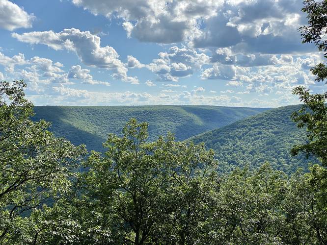
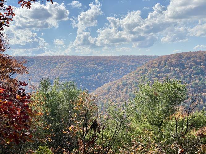
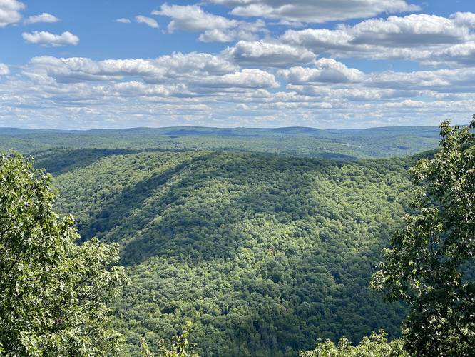
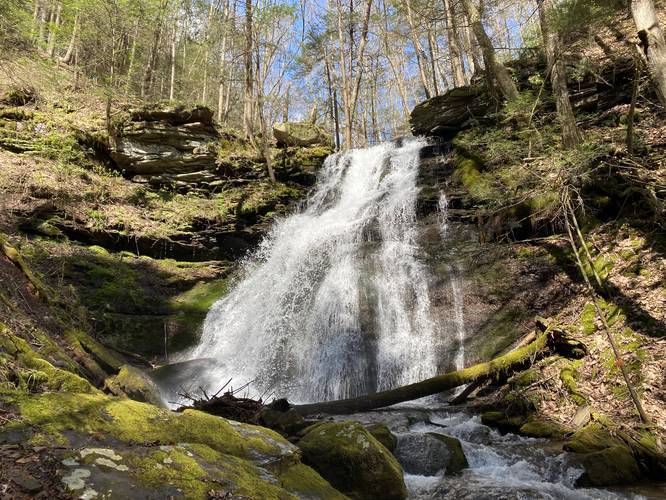
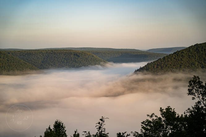
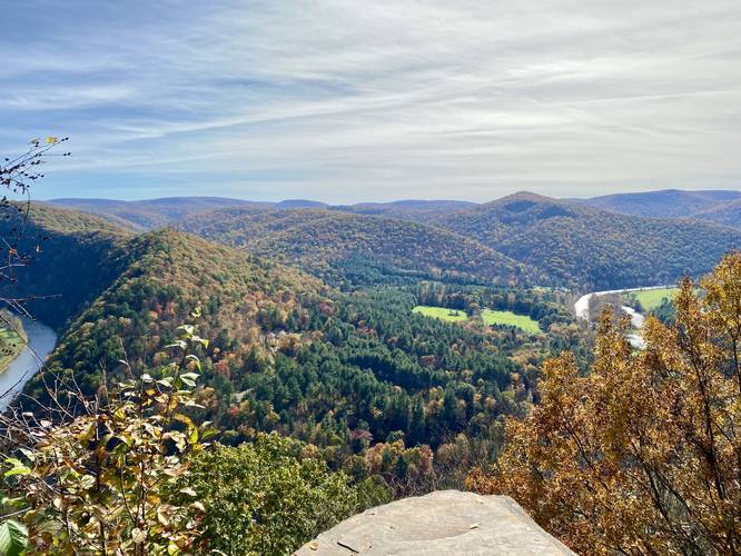
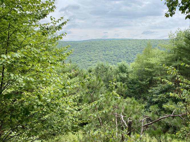
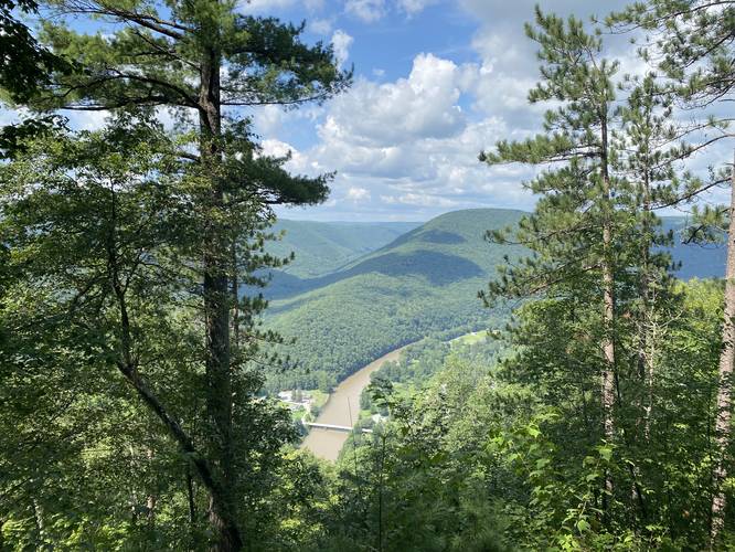
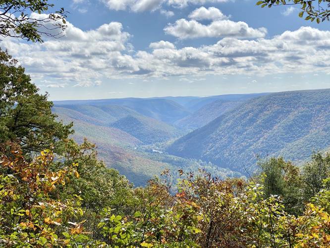
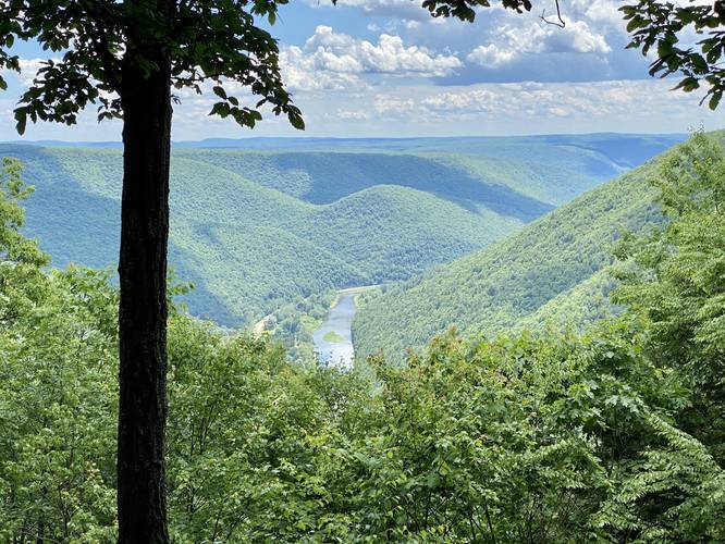
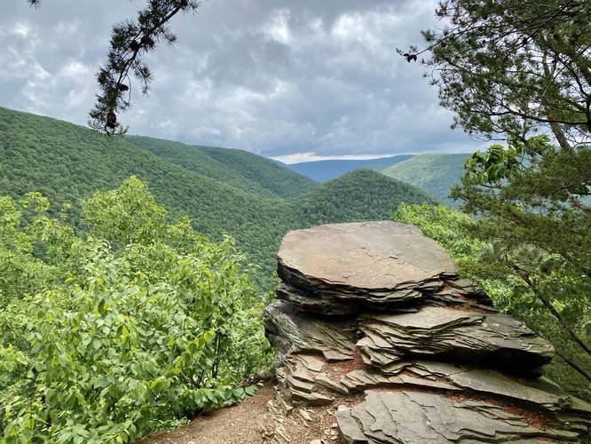
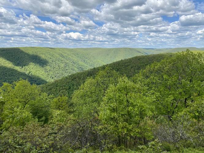
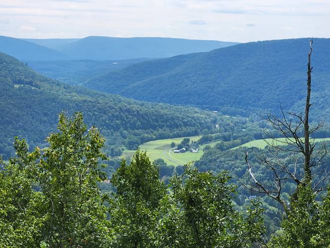
The Pine Creek Pinnacles (PCP20) hiking challenge was created in 2022 by Dave Miller (MyHikes Founder and Admin) as a way to promote the beautiful and often rugged terrain that Pine Creek Gorge has to offer to outdoor enthusiasts. Through this challenge, hikers will explore most of the official USGS Summits/Peaks that can be found throughout Pine Creek Gorge in addition to non-official Summits that either include a stunning vista, waterfall, some history, or are simply a difficult hike. Some hikes listed will not include views, but will instead force the adventurer to explore a new area away from popular routes.

Hikers who complete the challenge get their name added to the official PCP20 Members List on this page and are eligible to purchase stickers to show-off their accomplishment. Participation is 100% free!

Know Before You Go

  • The Pine Creek Pinnacles (PCP20) is a hiking challenge created by Dave Miller that involves completing 20 specific hikes, covering a total of 81 miles with over 23,000 feet of elevation gain within Pennsylvania's Grand Canyon.
  • The challenge is designed to showcase the diverse and rugged terrain of the Pine Creek Gorge by including both official USGS summits and other "pinnacles" chosen for their stunning vistas, waterfalls, historical significance, or challenging nature.
  • Participation in the challenge is free and self-paced, but hikers must track their progress and submit it for verification, either through a MyHikes account or a personal journal, to be added to the official members list.

How to Participate

  1. Sign up to create a user account. Your account is used to track progress and for verification.
  2. Download the MyHikes App below to easily upload your track data to your account for easier verfication.
  3. Find the Pine Creek Pinnacles List below to plan your hikes. Each trail must be hiked in full to count for this challenge.
  4. Before heading to each hike, you should actually read the trail notes before heading out to understand what you're getting yourself into. Trail notes include mileage, difficulty rating, warnings, points-of-interest and what to expect on each hke.
  5. Add a Trip Report to each trail after every hike to track your progress.
Please read our FAQs below for answers to common questions.

Pine Creek Pinnacles List


Default image for Big Rocks Loop, a 2.3-mile trail in Westfield, Pennsylvania (US)
  • 2.3 mi
  • Easy
  • Loop
0
Default image for South Hill Loop, a 2.8-mile trail in Middlebury Township, Pennsylvania (US)
  • 2.8 mi
  • Moderate
  • Loop
0
Default image for Mt. Nessmuk, a 6.3-mile trail in Wellsboro, Pennsylvania (US)
  • 6.3 mi
  • Moderate
  • Out-and-Back
0
Default image for Oak Point Mountain Trail, a 4.3-mile trail in Wellsboro, Pennsylvania (US)
  • 4.3 mi
  • Moderate
  • Out-and-Back
0
Default image for Mt. Tom Loop, a 3.6-mile trail in Wellsboro, Pennsylvania (US)
  • 3.6 mi
  • Strenuous
  • Loop
4.0
Default image for Barbour Rock Trail, a 1.0-mile trail in Wellsboro, Pennsylvania (US)
  • 1.0 mi
  • Moderate
  • Loop
5.0
Default image for Turkey Path, a 2.2-mile trail in Wellsboro, Pennsylvania (US)
  • 2.2 mi
  • Hard
  • Out-and-Back
5.0
Default image for Fork Hill Loop, a 6.4-mile trail in Morris, Pennsylvania (US)
  • 6.4 mi
  • Moderate
  • Loop
4.0
Default image for Johnson Cliff Vista via Mid State Trail, a 2.3-mile trail in Blackwell, Pennsylvania (US)
  • 2.3 mi
  • Hard
  • Out-and-Back
5.0
Default image for Bohen Trail, a 8.5-mile trail in Blackwell, Pennsylvania (US)
  • 8.5 mi
  • Strenuous
  • Out-and-Back
5.0
Default image for Gillespie Point via Mid State Trail, a 2.0-mile trail in Blackwell, Pennsylvania (US)
  • 2.0 mi
  • Hard
  • Out-and-Back
5.0
Default image for Chimney Rock Vista Hike, a 5.0-mile trail in Cedar Run, Pennsylvania (US)
  • 5.0 mi
  • Strenuous
  • Out-and-Back
5.0
Default image for Quarry Mountain Trail, a 2.4-mile trail in Slate Run, Pennsylvania (US)
  • 2.4 mi
  • Strenuous
  • Out-and-Back
3.0
Default image for Dragon's Back Trail, a 3.8-mile trail in Slate Run, Pennsylvania (US)
  • 3.8 mi
  • Moderate
  • Out-and-Back
5.0
Default image for Hemlock Mountain Loop, a 5.4-mile trail in Slate Run, Pennsylvania (US)
  • 5.4 mi
  • Strenuous
  • Loop
5.0
Default image for PA Half Dome, a 4.3-mile trail in Slate Run, Pennsylvania (US)
  • 4.3 mi
  • Strenuous
  • Out-and-Back
4.5
Default image for Golden Eagle Trail, a 9.9-mile trail in Cammal, Pennsylvania (US)
  • 9.9 mi
  • Strenuous
  • Loop
5.0
Default image for Bob Webber Trail, a 3.6-mile trail in Cammal, Pennsylvania (US)
  • 3.6 mi
  • Strenuous
  • Out-and-Back
5.0
Default image for Stone Cutter Vista Loop, a 3.7-mile trail in Ramsey, Pennsylvania (US)
  • 3.7 mi
  • Hard
  • Loop
5.0
Default image for Houselander Mountain, a 3.8-mile trail in Ramsey, Pennsylvania (US)
  • 3.8 mi
  • Strenuous
  • Out-and-Back
4.0

Clone the Trailmix!

Planning to hike the Pine Creek Pinnacles? Get yourself started by cloning the official trailmix into your list, just click the button below!

PCP20 Trail Map

Loading...

Official vs. Unofficial Peaks

Please note that some hikes listed do not lead to official USGS Peaks/Summits, like the Stone Cutter Vista, Half Dome Mountain, or the Turkey Path. These hikes were included to showcase unique or difficult hikes within the PA Grand Canyon.

On-Trail Exploration

This challenge is meant to promote on-trail hiking despite some of these official USGS Peaks being located off-trail - sometimes in dense forests. The main reason for the on-trail experience is because of the high population of the venomous Timber Rattlesnake in and around the PA Grand Canyon. If you wish to bushwhack directly to the summits you can, but hike at your own risk.

Warnings

Hikers should be aware that some of these hikes follow steep or treacherous terrain, pass near rattlesnake habitats, or guide the hiker through areas where there's no cell phone reception. All of the trails pass through areas where ticks are potentially present, which means increased chances for catching Lyme Disease or Powassan Virus. With all of these things in mind, this challenge is not meant for the beginner hiker, but rather more experienced outdoor enthusiasts who understand these cautions and can plan accordingly. Remember that you're hiking at your own risk at all times.

PCP20 Members List

Hikers that have completed the Pine Creek Pinnacles (PCP20).
Name
From
Date Completed
Dave Miller (Admin)
Wellsboro, PA
March 19, 2022
Rebekah VanDergrift (BeccaV)
Wellsboro, PA
April 15, 2023
David Oliver (DO)
Hackettstown, NJ
April 21, 2023
Devin Howe (DLH570)
Wellsboro, PA
March 15, 2024
Bruce Dieffenbach (Bdief)
Troy, PA
May 24, 2025
Laura Taylor (LT23)
Troy, PA
May 24, 2025

Winter PCP20 Members List

Hikers that have completed the Winter Pine Creek Pinnacles (PCP20) between December 21 and March 20.
Name
From
Date Completed
Devin Howe (DLH570)
Wellsboro, PA
March 15, 2024
David Oliver (DO)
Hackettstown, NJ
March 20, 2024

Buy PCP20 Stickers

FAQs

How do I track each hike?

One of two ways:

  1. (Preferred) Sign up to create a MyHikes account. On each hike listed on the site, simply leave a Trip Report or upload photos from the trail. Each Trip Report has the option to upload a GPX file, if you wish, in addition to a Completed Date. This Completed Date field is used to track the exact day you did the hike and/or to retroactively submit your hike. Leaving notes about your hike within the Trip Report is optional, but recommended to help other hikers.
  2. Keep your own personal hiking journal in whatever manner you see fit - notepad, Notes app, whatever.

How do I submit my data for the challenge?

With a MyHikes account: Once you've completed the challenge, use the form on the contact us page requesting Dave to verify your data and use the subject of Pine Creek Pinnacles Submission. You can also email myhikes.org@gmail.com with the subject of Pine Creek Pinnacles Submission. Include your MyHikes username in the email so I can find your Trip Reports and photos.

Without a MyHikes account: Please email myhikes.org@gmail.com with the subject of Pine Creek Pinnacles Submission. Include a list of the hikes, when they were completed, and supply photos from each one if you can - otherwise, pictures of your hiking journal are accepted. Unique and timestamped GPX files are also accepted.

I hiked these in the past, can I enter the challenge retroactively?

Yes, this challenge is retroactive. If you've hiked these routes before the challenge was created, you can still submit your data. Please either create a MyHikes account to add Trip Reports to each hike or email myhikes.org@gmail.com with pictures of journal entries from your hikes. We'll also accept any GPX file or pictures from your past trips.

Do I really need to hike each location to complete the challenge?

Yes, each trail must be hiked in full. If you decide to hike from a different location, we'll accept a greater-than-or-equal mileage and elevation gain along a different route that reaches the same destination. Please include a map drawing or GPX file for us to validate the different route when submitting your challenge data.

How long can I take to complete the challenge?

This hiking challenge is self-paced, so take as long as you need. It took Dave a couple of years to slowly explore around Pine Creek Gorge enough to first conceptualize a challenge before picking these 20 hikes as the main challenge for himself.

I hiked these trails before and my data was validated by a different organization for a different challenge - do I still need to submit my data?

Yes, you still need to submit your data to myhikes.org@gmail.com to have your name added to the official Pine Creek Pinnacles Members List.

What do I get if I complete the challenge?

Every hiker that completes this challenge will receive:

  • Their first name, last name, MyHikes username (if applicable), and location (if they choose) added to the PCP20 Members List on this page.
  • The ability to purchase Member Stickers, which cost $15 for (3) stickers.
The idea is to showcase hikers that have completed the challenge over the course of many years, while also highlighting where folks have traveled from.

What do the Member Stickers look like?

Pine Creek Pinnacles Member sticker
Member
Pine Creek Pinnacles Winter Member sticker
Winter Member

Why do I need to pay for a Member Sticker?

While participating and even completing the challenge is free, it costs $15 for (3) Member Stickers. The money is put back into MyHikes to keep the lights on and thus keep the Pine Creek Pinnacles going.

Note that there are no club fees or annual dues to participte or complete this challenge. Non-members may also purchase cheaper PCP20 stickers to show-off your work-in-progress or support.

Who runs this challenge?

MyHikes, by Dave Miller. Dave lives in to Wellsboro, PA and has mapped and written about 400+ miles of trails in and around Pine Creek Gorge on MyHikes between June, 2019 and March 2022.

Where does the money go for sticker payments?

The money is put back into MyHikes to continue sharing public trail information. The platform is mostly all free to use and is run by one person. Operating, however, is not free. We map public trails and provide detailed notes and points-of-interest for everyone to explore - not to mention the countless hours coding, adding new features, maintaining, upgrading, and administration.

Why are there some easier hikes on here like Big Rocks and South Hill?

The Pine Creek Pinnacles is a challenge, so if you want to complete it, you also really have to want it. The North Canyon (Marsh Creek area) of the PA Grand Canyon is overlooked by most hikers, but there's still plenty to explore in that area. By including shorter and easier hikes like Big Rocks and South Hill, hikers get to explore an area that they may have otherwise skipped over. Most of the hikes in the North Canyon that are on this list are easier and flatter, but generally pass through the USGS Summits/Peaks. Additionally, if you want to create more of a challenge, you can even hike those spots from a further distance to increase elevation gain or mileage; that's up to you!

Is there a Winter version of the Pine Creek Pinnacles?

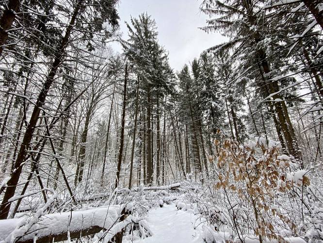
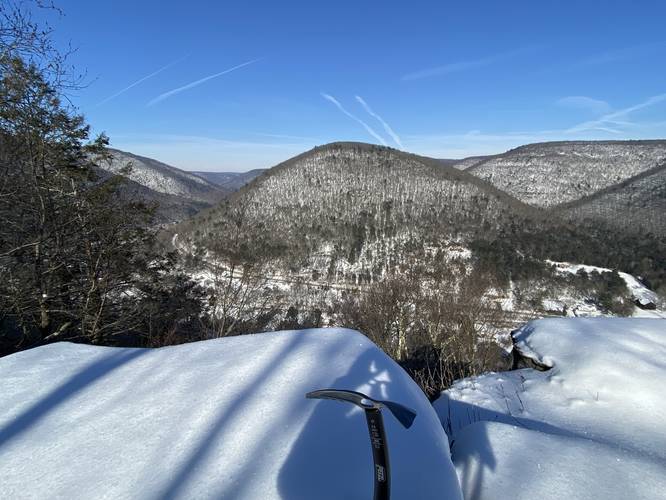
Yes! Please note that the Turkey Path is closed during the winter, so that hike is excluded from the winter challenge. By default, there are two ways to complete the Pine Creek Pinnacles:

  1. Traditional: Hike all 20 locations any time of the year over any number of years.
  2. Winter: Hike all 19 locations (exlcudes the Turkey Path) between December 21 and March 20, combined over any number of years. If you hike one of the Pine Creek Pinnacles in the Winter, it counts for both Winter and Traditional so you do not need to revisit that hike.
The Winter version is more challenging because most of these locations are harder to reach during the winter. For example, Barbour Rock in the winter is 8-miles out-and-back starting at the West Rim Trail's northern terminous instead of the 1-mile loop during warmer months. Half Dome Mountain (PA Half Dome), for example, may be treacherous during the winter as well due to its insanely steep elevation grade. Remember you're hiking at your own risk and it's always best to over-evaluate dangerous situations. If you do not feel totally comfortable, turning around ensures you can go home at the end of the day. Nature doesn't care either way.

To plan for winter hiking, please check out our How to Hike in the Winter guide for safety tips, tricks, and gear lists.

Why isn't the West Rim Trail on the list?

While the West Rim Trail is one of Pennsylvania's most popular backpacking and day hike trails in Pine Creek Gorge, it's not on the list because of its length. The Pine Creek Pinnacles is meant to breakup the canyon into smaller bite-sized chunks and while the West Rim Trail is a beautiful part of Pine Creek Gorge, it felt a bit brutal to add that to the official list.

Why isn't my favorite spot on the list?

There are plenty of places within the PA Grand Canyon that were not included; however, to create a challenge that includes every single unique or interesting place would not only take a lifetime to explore first, but it would be unrealistic to expect hikers to participate. The Pine Creek Pinnacles is meant to be an achieveable challenge, especially for those who have to drive long distances to reach the canyon in the first place.

Who created this challenge and why?

The Pine Creek Pinnacles hiking challenge was created in 2022 by Dave Miller (MyHikes Founder and Admin) as a way to promote the beautiful and often rugged terrain that Pine Creek Gorge has to offer to outdoor enthusiasts. Miller, a transplant to Wellsboro, PA, has mapped and written over 400-miles of trails from the area on MyHikes between 2019 and 2022. After several years of exploring, he wanted to showcase Pine Creek Gorge by creating a challenge like the "ADK 46ers" or "NH 48". Despite Pennsylvania's lack of rocky peaks/summits, Dave figured that a challenge that combined the USGS peaks/summits with other "pinnacles" of Pine Creek could make for a really interesting way for hikers to explore the canyon. Additionally, the challenge is meant to drum up extra tourism for the area to help some of these tiny communities in/around Pine Creek Gorge.

🍪 We use cookies to learn about site usage and to serve map tiles. You may block cookies manually in the browser. By continuing you agree. Learn more