The Quarry Mountain Trail at Tiadaghton State Forest near Slate Run, Pennsylvania is a strenuous 2.4-mile out-and-back trail that features a vista point and an old quarry site atop the mountain, and also connects to the popular Dragon's Back Trail which has a stunning vista of Slate Run and Pine Creek.
Hike Description
This hike begins at the trailhead along PA Route 414 in Slate Run and follows the yellow blazes of the Quarry Mountain Trail all the way up to the summit of Quarry Mountain. The trail follows several switchbacks as it makes it way up the mountain at around 1,024-feet elevation gain from the trailhead to the summit.
In the first 0.5-miles of the trail, it leads along a rocky narrow pathway with steep but shallow mossy slopes along the side. Mushroom hunters will find this trail, especially in late Summer, ripe with more than a handful of different fungi species, especially along the mossy sections.
Eventually the trail hits a wider switchback as it ascends the mountain - this switchback (speculating) looks like it has old ruts along both sides, potentially indicating that this used to be an old wagon road that served the quarry.
Finally, the trail reaches a false summit around mile 0.92, which is technically the end of the "official" trail on the park map. This false summit is also where the Dragon's Back Trail begins (there was no signage for the Dragon's Back Trail at either trail terminus / trailhead as of August 2021).
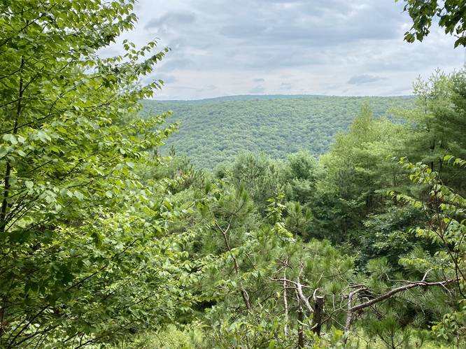
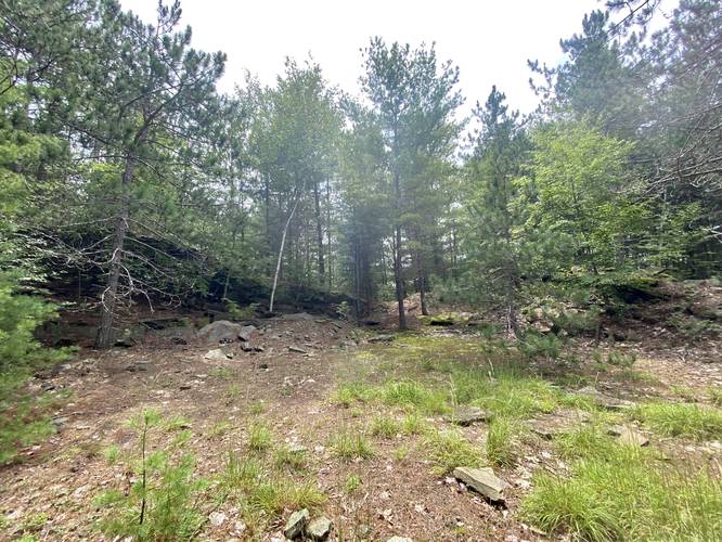
Quarry Mountain Vista and Abandoned Quarry Site
At the false summit junction, I ended up continuing up Quarry Mountain along the last unofficial switchback, which lead to an unexpected vista around mile 1. This vista gives hikers a view of the Wolf Run Wild Area, and a mountain range that's encompassed by the Golden Eagle Trail - another popular day hike. Continuing on from the vista this track leads out to the old quarry site that sits near the summit of Quarry Mountain around mile 1.15. There's not much left at the quarry site other than several large piles of rock, some of which look like they could be nice dens for foxes or other woodland animals.
From the summit and the quarry site, the hike back is identical to the hike up. I ended up exploring the Dragon's Back Trail on this hike as well, which has a stunning vista of Slate Run and Pine Creek, so it's worth taking that detour while climbing Quarry Mountain. These two trails can also be used to connect to the Golden Eagle Trail, which has several more vistas along a similar elevation ridge line,
Parking
Hikers can find parking near the coordinates provided - both at the parking turnout along PA 414 next to the trailhead and at the Tomb Flats parking area just across the street.
Pets
Dogs are allowed if leashed.
Backpacking and Camping
Backpacking is technically allowed along this trail, but only within the state forest section - as this trail does pass through some state game lands. Please follow all rules when dispersed / primitive / backcountry camping. Also note that as of August 2021, there were no predefined campsites; however, there was a tiny fire ring at the vista - this did not indicate an actual campsite.
Warning
Rattlesnakes: This area is known for the Timber Rattlesnake. If you see one, give it as much space as you can and continue hiking. With regard to dogs, it's smart to keep them leashed at all times to reduce the chance of them getting a snake bite as well.
Pine Creek Pinnacles (PCP20)
This hike is part of the Pine Creek Pinnacles hiking challenge. For more information, details, and FAQs, please visit our Pine Creek Pinnacles (PCP20) page.
Hike Description
This hike begins at the trailhead along PA Route 414 in Slate Run and follows the yellow blazes of the Quarry Mountain Trail all the way up to the summit of Quarry Mountain. The trail follows several switchbacks as it makes it way up the mountain at around 1,024-feet elevation gain from the trailhead to the summit.
In the first 0.5-miles of the trail, it leads along a rocky narrow pathway with steep but shallow mossy slopes along the side. Mushroom hunters will find this trail, especially in late Summer, ripe with more than a handful of different fungi species, especially along the mossy sections.
Eventually the trail hits a wider switchback as it ascends the mountain - this switchback (speculating) looks like it has old ruts along both sides, potentially indicating that this used to be an old wagon road that served the quarry.
Finally, the trail reaches a false summit around mile 0.92, which is technically the end of the "official" trail on the park map. This false summit is also where the Dragon's Back Trail begins (there was no signage for the Dragon's Back Trail at either trail terminus / trailhead as of August 2021).
Quarry Mountain Vista and Abandoned Quarry Site
At the false summit junction, I ended up continuing up Quarry Mountain along the last unofficial switchback, which lead to an unexpected vista around mile 1. This vista gives hikers a view of the Wolf Run Wild Area, and a mountain range that's encompassed by the Golden Eagle Trail - another popular day hike. Continuing on from the vista this track leads out to the old quarry site that sits near the summit of Quarry Mountain around mile 1.15. There's not much left at the quarry site other than several large piles of rock, some of which look like they could be nice dens for foxes or other woodland animals.
From the summit and the quarry site, the hike back is identical to the hike up. I ended up exploring the Dragon's Back Trail on this hike as well, which has a stunning vista of Slate Run and Pine Creek, so it's worth taking that detour while climbing Quarry Mountain. These two trails can also be used to connect to the Golden Eagle Trail, which has several more vistas along a similar elevation ridge line,
Parking
Hikers can find parking near the coordinates provided - both at the parking turnout along PA 414 next to the trailhead and at the Tomb Flats parking area just across the street.
Pets
Dogs are allowed if leashed.
Backpacking and Camping
Backpacking is technically allowed along this trail, but only within the state forest section - as this trail does pass through some state game lands. Please follow all rules when dispersed / primitive / backcountry camping. Also note that as of August 2021, there were no predefined campsites; however, there was a tiny fire ring at the vista - this did not indicate an actual campsite.
Warning
Rattlesnakes: This area is known for the Timber Rattlesnake. If you see one, give it as much space as you can and continue hiking. With regard to dogs, it's smart to keep them leashed at all times to reduce the chance of them getting a snake bite as well.
Pine Creek Pinnacles (PCP20)
This hike is part of the Pine Creek Pinnacles hiking challenge. For more information, details, and FAQs, please visit our Pine Creek Pinnacles (PCP20) page.