Houselander Mountain at Tiadaghton State Forest near Ramsey, Pennsylvania is a strenuous 3.8-mile out-and-back hike that leads to the summit of Houselander Mountain and features stunning views of the southern end of Pennsylvania's Grand Canyon, Pine Creek Gorge.
Trails
This hike follows one named trail, Houselander Trail. The trail follows yellow blazes as it ascents Houselander Mountain up to the first "bench" in the mountain, then begins to follow red blazes to the summit.
Hike Description
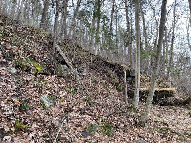
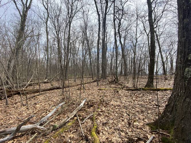
This trail starts off extremely steep along rocky terrain as it slowly makes its way to a switchback, located approximately 0.2-miles from the trailhead. Along the way - especially during colder months - hikers will notice the Stone Cutter Vista located across Pine Creek. Hikers should take this section slow and watch their footing to ensure they don't accidentally tumble down the steep mountainside here. Right at the first switchback, hikers will notice a large rock outcropping along the mountain. Just beyond here is an old quarry site - note the straight-cut rock. The trail then makes its way up the southern end of this small quarry. After passing the quarry section, hikers will pass about 6 switchbacks as they ascend Houselander Mountain.
Perched Rock - Mile 1
Around mile 1, hikers will find another rock perched on the side of the mountain. There's an obstructed view here during the colder months.
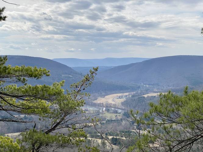
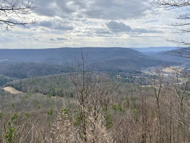
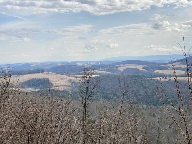
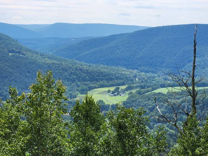
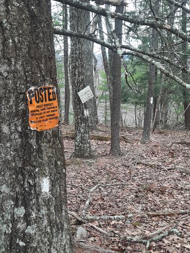
Canyon Vistas - Mile 1.25 to 1.55
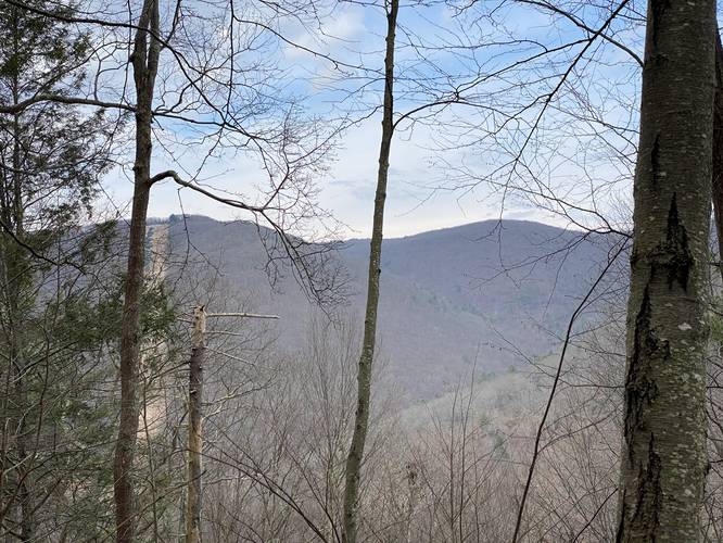
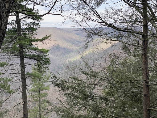
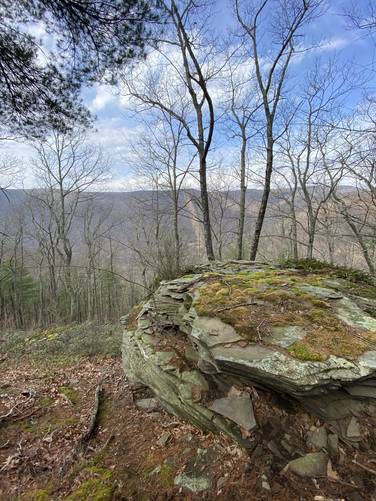
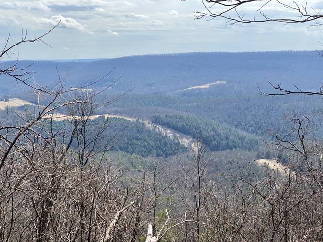
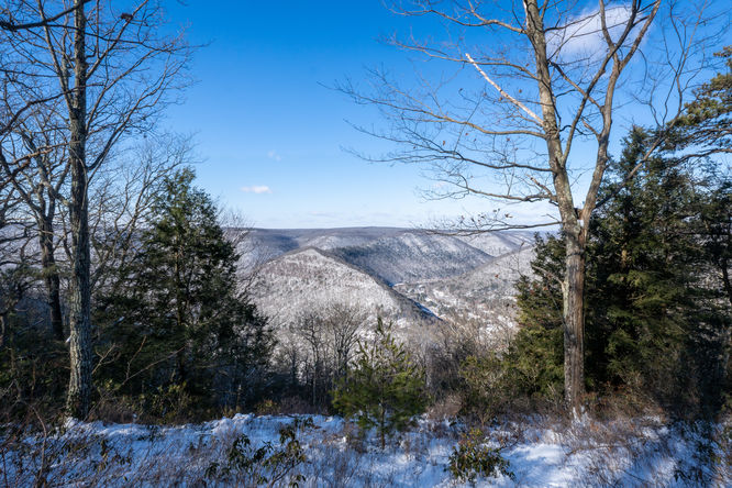
After passing the 6 or 7 switchbacks that lead up the mountain, including several rocky outcroppings where Timber Rattlesnakes might live, hikers will reach a bench in the mountain where stunning south-facing views of the PA Grand Canyon can be found, around mile 1.25. Please note that as the trail makes its way up to this mountain bench, there's also private property posted - please stay off of the private property. It's recommended to bring an offline mapping tool to help identify which land is public and which is private. Hikers can walk down the slope of Houselander Mountain for about 20-feet, near one of these posted signs, to find a nice view next to a rock. The private property line is just behind the posted sign (facing due south) so one can stand on the rock and take a photo, but do not venture any further to avoid trespassing. The trail will then start to follow red blazes as it heads east along this flatter bench in the mountain, passing several vistas along the way. These vistas give hikers stunning views of the southern end of Pine Creek Gorge.
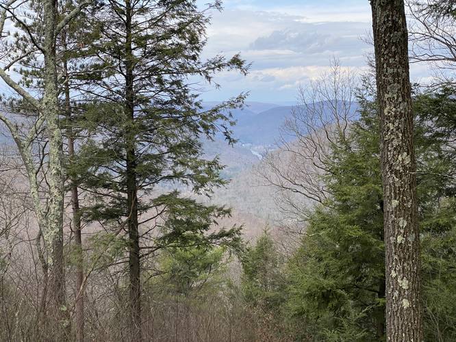
Summiting Houselander Mountain and Summit Vista
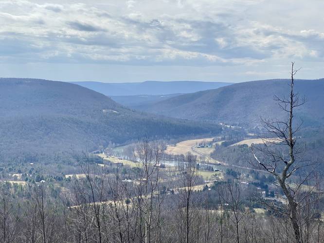
After hikers explore the vistas along the flat bench in the mountain, the red blazes of the Houselander Trail will head back up the mountain. As the trail ascends the mountain, it provides at least two false summits. Once near the USGS labelled summit, hikers will find a vista cut-out in the trees that faces north into Waterville, PA with views of Pine Creek and parts of the PA Grand Canyon. Just beyond this summit vista lies the true "summit" to Houselander Mountain, as labelled on the USGS maps. While out exploring, the labeled summit actually appeared lower than the land near the vista; however, this recording stops just next to the USGS-labelled summit of Houselander Mountain.
Hiking Out
While the descent of Houselander Mountain is significantly easier than climbing up, the terrain can be steep, slippery with leaves, and rocky. Take your time in steeper sections and use your hands where applicable. Note that this took me - an avid hiker - approximately 1 hour 20 minutes to summit along with stopping for photos, while descending took 52 minutes for a total of 2 hours and 12 minutes.
Parking
Hikers will find almost no parking for this trailhead and thus parking at the coordinates provided can be extremely dangerous - park at your own risk. There's enough room for at least 1, but maybe 2 cars only if your vehicle can fit over the white line (do not attempt to park a large truck here - smaller and more compact vehicles can fit including CRVs). Be careful getting in or out of your vehicle since PA-414 is a state highway. If you feel uncomfortable parking here, you can also park at the Stone Cutter Vista Loop parking area (41.284489, -77.324675) and walk down the highway, but that's also risky.
Warnings
Rattlesnakes: The Timber Rattlesnake calls this area home amongst the rocky outcroppings in the mountain. This trail passes plenty of rocky sections and outcrops where these rattlesnakes might be living. They're usually out on the trails and roaming between the end of April and early October.
No cell service: There's almost no cell service on this mountain, until you get near the top - as of March 2022 with Verizon.
Steep terrain: This trail follows very steep, dangerous, and rocky terrain. Watch your steps, hike at your own risk and bring the proper footwear, water, and trekking poles to aid in climbing the mountain.
Pets
Dog are allowed if leashed and their waste should be carried out by the hiker. Note that the steep terrain of this hike may be difficult for some dogs.
Biking
Note that biking is only permitted along the red blazes of Houselander Trail - located from the bench in the mountain up through the service road (not mapped in this GPS data).
Camping and Backpacking
Backpackers and campers can setup camp off-trail here, but must follow all state forest rules and regulations when backcountry / primitive / dispersed camping. Note that there are no pre-defined campsites, but plenty of space to setup camp along the bench in the mountain.
Pine Creek Pinnacles (PCP20)
This hike is part of the Pine Creek Pinnacles hiking challenge. For more information, details, and FAQs, please visit our Pine Creek Pinnacles (PCP20) page.
Trails
This hike follows one named trail, Houselander Trail. The trail follows yellow blazes as it ascents Houselander Mountain up to the first "bench" in the mountain, then begins to follow red blazes to the summit.
Hike Description
This trail starts off extremely steep along rocky terrain as it slowly makes its way to a switchback, located approximately 0.2-miles from the trailhead. Along the way - especially during colder months - hikers will notice the Stone Cutter Vista located across Pine Creek. Hikers should take this section slow and watch their footing to ensure they don't accidentally tumble down the steep mountainside here. Right at the first switchback, hikers will notice a large rock outcropping along the mountain. Just beyond here is an old quarry site - note the straight-cut rock. The trail then makes its way up the southern end of this small quarry. After passing the quarry section, hikers will pass about 6 switchbacks as they ascend Houselander Mountain.
Perched Rock - Mile 1
Around mile 1, hikers will find another rock perched on the side of the mountain. There's an obstructed view here during the colder months.
Canyon Vistas - Mile 1.25 to 1.55
After passing the 6 or 7 switchbacks that lead up the mountain, including several rocky outcroppings where Timber Rattlesnakes might live, hikers will reach a bench in the mountain where stunning south-facing views of the PA Grand Canyon can be found, around mile 1.25. Please note that as the trail makes its way up to this mountain bench, there's also private property posted - please stay off of the private property. It's recommended to bring an offline mapping tool to help identify which land is public and which is private. Hikers can walk down the slope of Houselander Mountain for about 20-feet, near one of these posted signs, to find a nice view next to a rock. The private property line is just behind the posted sign (facing due south) so one can stand on the rock and take a photo, but do not venture any further to avoid trespassing. The trail will then start to follow red blazes as it heads east along this flatter bench in the mountain, passing several vistas along the way. These vistas give hikers stunning views of the southern end of Pine Creek Gorge.
Summiting Houselander Mountain and Summit Vista
After hikers explore the vistas along the flat bench in the mountain, the red blazes of the Houselander Trail will head back up the mountain. As the trail ascends the mountain, it provides at least two false summits. Once near the USGS labelled summit, hikers will find a vista cut-out in the trees that faces north into Waterville, PA with views of Pine Creek and parts of the PA Grand Canyon. Just beyond this summit vista lies the true "summit" to Houselander Mountain, as labelled on the USGS maps. While out exploring, the labeled summit actually appeared lower than the land near the vista; however, this recording stops just next to the USGS-labelled summit of Houselander Mountain.
Hiking Out
While the descent of Houselander Mountain is significantly easier than climbing up, the terrain can be steep, slippery with leaves, and rocky. Take your time in steeper sections and use your hands where applicable. Note that this took me - an avid hiker - approximately 1 hour 20 minutes to summit along with stopping for photos, while descending took 52 minutes for a total of 2 hours and 12 minutes.
Parking
Hikers will find almost no parking for this trailhead and thus parking at the coordinates provided can be extremely dangerous - park at your own risk. There's enough room for at least 1, but maybe 2 cars only if your vehicle can fit over the white line (do not attempt to park a large truck here - smaller and more compact vehicles can fit including CRVs). Be careful getting in or out of your vehicle since PA-414 is a state highway. If you feel uncomfortable parking here, you can also park at the Stone Cutter Vista Loop parking area (41.284489, -77.324675) and walk down the highway, but that's also risky.
Warnings
Rattlesnakes: The Timber Rattlesnake calls this area home amongst the rocky outcroppings in the mountain. This trail passes plenty of rocky sections and outcrops where these rattlesnakes might be living. They're usually out on the trails and roaming between the end of April and early October.
No cell service: There's almost no cell service on this mountain, until you get near the top - as of March 2022 with Verizon.
Steep terrain: This trail follows very steep, dangerous, and rocky terrain. Watch your steps, hike at your own risk and bring the proper footwear, water, and trekking poles to aid in climbing the mountain.
Pets
Dog are allowed if leashed and their waste should be carried out by the hiker. Note that the steep terrain of this hike may be difficult for some dogs.
Biking
Note that biking is only permitted along the red blazes of Houselander Trail - located from the bench in the mountain up through the service road (not mapped in this GPS data).
Camping and Backpacking
Backpackers and campers can setup camp off-trail here, but must follow all state forest rules and regulations when backcountry / primitive / dispersed camping. Note that there are no pre-defined campsites, but plenty of space to setup camp along the bench in the mountain.
Pine Creek Pinnacles (PCP20)
This hike is part of the Pine Creek Pinnacles hiking challenge. For more information, details, and FAQs, please visit our Pine Creek Pinnacles (PCP20) page.