Gillespie Point via Mid State Trail (MST) at Tioga State Forest in Blackwell, Pennsylvania is a difficult 2-mile out-and-back trail that leads to a stunning vista point - Gillespie Point. Gillespie Point sits at the top of a mountain high above Blackwell, Pennsylvania near the southern end of the West Rim Trail within the Grand Canyon of Pennsylvania.
The trailhead can be found along Big Run Road directly where the road makes a right-hand turn heading up the mountain - just a couple hundred feet from PA-414.
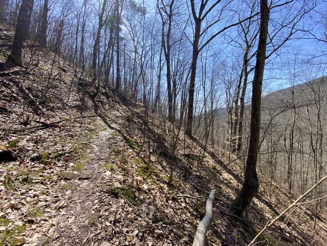
The trail follows orange blazes, the main blaze color for the Mid State Trail, and heads up the mountain at a moderate to steep grade. The trail has several sections where the mountain's hillside slopes through the terrain of the trail, making it difficult to hike on flat ground. This is especially annoying and dangerous during the winter when the snow on the trail makes it slippery.
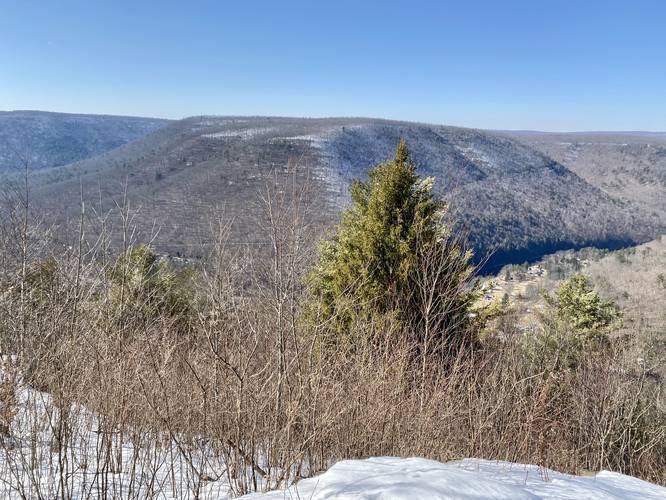
As the trail ascends the mountain, during the colder months, there are obstructed views through the trees of Blackwell, Pine Creek, the Grand Canyon of Pennsylvania, and the southern section of the West Rim Trail.
Around a half-mile into the hike, or about half-way, the trail will turn away from the mountain's edge and head up toward the summit. This section of the trail is easier to hike because of the flat ground, but the elevation grade changes several times from easy to steep. There are a few false summits along the way up, so plan on a half-mile hike from the turn up to Gillespie Point.
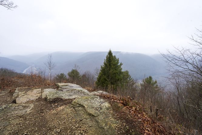
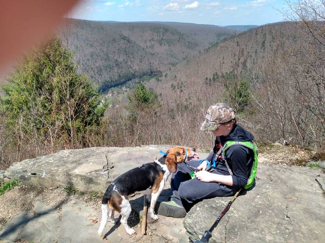
Right before reaching Gillespie Point, hikers will find a small rock outcropping. Follow the orange blazes atop the rock outcropping to reach Gillespie Point and the stunning vista. The vista point has several rocks that hikers can use as seats. Note that the wind is fairly strong at the top of the mountain.
The hike down is the same way up and is often a bit quicker.
Parking
Hikers can find one or two very small turnout spots along the road next to the trailhead - at the coordinates provided. You can find more parking at the Pine Creek Rail Trail parking lot (41.5562, -77.3817), about 0.3-miles one-way from the trailhead - located just before the bridge crossing of Pine Creek along PA-414. Please do not block the road or overflow the parking area if this small turnout is full and park at 41.5562, -77.3817 instead.
Pets
Dogs are allowed if leashed.
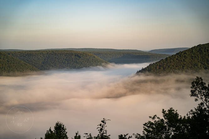
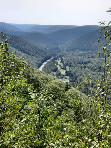
Vista
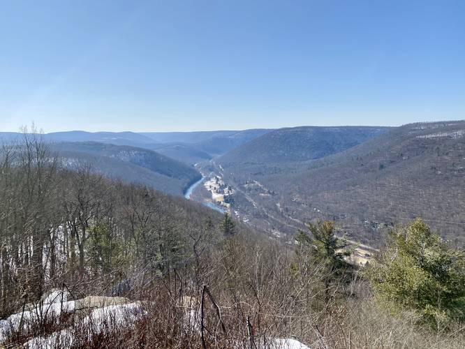
The vista at Gillespie Point is not easy to reach as the trail ascends the mountain for the entire length of this hike. Hikers should come prepared with proper footwear, trekking poles, and ice spikes during the winter. From the vista, you'll get an amazing view of the Grand Canyon of Pennsylvania high above Blackwell, Pennsylvania. Across the creek is the West Rim Road and the West Rim Trail.
Warning
This trail can be a bit dangerous during the winter when the trail is full of snow and ice. There are section of the trail that run along a steep mountain slope with minimal footing. Trekking poles and ice spikes are recommended. Hike at your own risk.
Time to Hike
The average hiker should expect to take about 1.5 to 2 hours hiking this trail out-and-back.
Mid State Trail Section Hike
This hike follows a small section of the much larger Mid State Trail.
PA Pyramid
This mountain is also known as the "PA Pyramid" / "Pennsylvania Pyramid" - as seen from the cliffs along PA Route 414, south of this mountain. See the photo album "PA Pyramid" for a picture showing Gillespie Point from this vantage point along PA Route 414.
Pine Creek Pinnacles (PCP20)
This hike is part of the Pine Creek Pinnacles hiking challenge. For more information, details, and FAQs, please visit our Pine Creek Pinnacles (PCP20) page.
The trailhead can be found along Big Run Road directly where the road makes a right-hand turn heading up the mountain - just a couple hundred feet from PA-414.
The trail follows orange blazes, the main blaze color for the Mid State Trail, and heads up the mountain at a moderate to steep grade. The trail has several sections where the mountain's hillside slopes through the terrain of the trail, making it difficult to hike on flat ground. This is especially annoying and dangerous during the winter when the snow on the trail makes it slippery.
As the trail ascends the mountain, during the colder months, there are obstructed views through the trees of Blackwell, Pine Creek, the Grand Canyon of Pennsylvania, and the southern section of the West Rim Trail.
Around a half-mile into the hike, or about half-way, the trail will turn away from the mountain's edge and head up toward the summit. This section of the trail is easier to hike because of the flat ground, but the elevation grade changes several times from easy to steep. There are a few false summits along the way up, so plan on a half-mile hike from the turn up to Gillespie Point.
Right before reaching Gillespie Point, hikers will find a small rock outcropping. Follow the orange blazes atop the rock outcropping to reach Gillespie Point and the stunning vista. The vista point has several rocks that hikers can use as seats. Note that the wind is fairly strong at the top of the mountain.
The hike down is the same way up and is often a bit quicker.
Parking
Hikers can find one or two very small turnout spots along the road next to the trailhead - at the coordinates provided. You can find more parking at the Pine Creek Rail Trail parking lot (41.5562, -77.3817), about 0.3-miles one-way from the trailhead - located just before the bridge crossing of Pine Creek along PA-414. Please do not block the road or overflow the parking area if this small turnout is full and park at 41.5562, -77.3817 instead.
Pets
Dogs are allowed if leashed.
Vista
The vista at Gillespie Point is not easy to reach as the trail ascends the mountain for the entire length of this hike. Hikers should come prepared with proper footwear, trekking poles, and ice spikes during the winter. From the vista, you'll get an amazing view of the Grand Canyon of Pennsylvania high above Blackwell, Pennsylvania. Across the creek is the West Rim Road and the West Rim Trail.
Warning
This trail can be a bit dangerous during the winter when the trail is full of snow and ice. There are section of the trail that run along a steep mountain slope with minimal footing. Trekking poles and ice spikes are recommended. Hike at your own risk.
Time to Hike
The average hiker should expect to take about 1.5 to 2 hours hiking this trail out-and-back.
Mid State Trail Section Hike
This hike follows a small section of the much larger Mid State Trail.
PA Pyramid
This mountain is also known as the "PA Pyramid" / "Pennsylvania Pyramid" - as seen from the cliffs along PA Route 414, south of this mountain. See the photo album "PA Pyramid" for a picture showing Gillespie Point from this vantage point along PA Route 414.
Pine Creek Pinnacles (PCP20)
This hike is part of the Pine Creek Pinnacles hiking challenge. For more information, details, and FAQs, please visit our Pine Creek Pinnacles (PCP20) page.