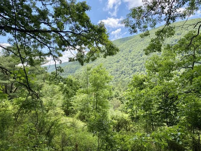
The Golden Eagle Trail at Tiadaghton State Forest and within the Wolf Run Wild Area near Cammal, Pennsylvania is a strenuous 9.9-mile loop hike that features breathtaking views of the Wolf Run Wild Area and Pine Creek, with the main attraction of this hike being the Raven's Horn vista point.
Trail Description
The hike begins across the street from the Utceter Station / Clark Farm parking area for the Pine Creek Trail - also where hikers can find parking. Hikers will begin by following a spur trail that leads to the Golden Eagle Trail (loop), which is a moderate uphill climb among hemlocks and moss. Hikers will find a trail registry box with a sign-in sheet within about 0.1-miles from the road - it is suggested to sign-in in case something happens to you on the trail.
At 0.4 miles the spur trail reaches a junction with the Golden Eagle Trail loop. At the junction hikers can take a right-hand turn to head towards the vistas for a shorter hike; however, reaching Raven's Horn vista is still a strenuous climb if you plan to take a right-hand turn here. This recording goes straight at the junction, following the Golden Eagle Trail in a clockwise direction, which is by far the more difficult direction to hike this trail in.
From here, the hike follows Bonnell Run creek where along the route hikers will find old growth hemlocks along the side of the trail. At 0.8 miles the trail finally heads downhill and runs directly adjacent to the creek. The first actual creek Crossing is at mile 1.6. When hiking this trail in mid June 2020, the creek bed was virtually dried up in most places. Just after the first creek crossing along Bonnell Run, hikers will enter State Game Lands number 68.
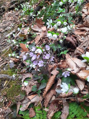
The trail will end up crossing Bonnell Run approximately twenty times in total. Around mile 3.1 the trail begins heading uphill along a very steep grade to reach the top of the mountain and northern vista points - this mountain climb is named "The Saddle". The climb up the this hill is very steep and the terrain is made up of loose rocks, which makes this section of the trail very strenuous. Once at the top, the trail will level out slightly and pass Mountain Laurel which can be found blooming in mid-June. Eventually the trail will continue heading uphill at a more gradual grade before reaching another trail junction.
At the top of the hill above Bonnell Run, hikers will reach a junction with a sign that labels the Hilborn Trail. There will be yellow blazes to your left (Dragon's Back Trail), yellow blazes straight (Hilborn Trail) and orange blazes to your right. Take a right-hand turn here to continue following the orange blazes of the Golden Eagle Trail along this wide and grassy section of trail, which looks more like a service road.
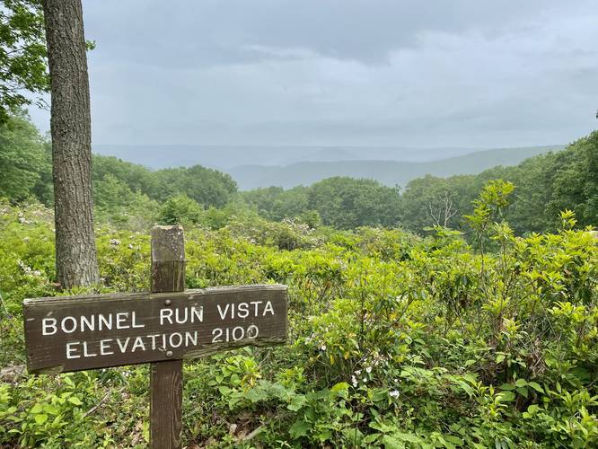
Bonnell Run Vista - Mile 3.8
At approximately mile 3.8 or slightly less, hikers will reach the Bonnell Run Vista along the mountain ridge. Just after Bonnell Run Vista the Golden Eagle Trail will take a right-hand turn once again, following a very wide trail.
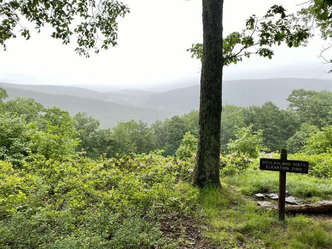
Beulahland Vista - Mile 4
Not long after stopping at Bonnell Run Vista, hikers will reach the Beulahland Vista point facing north east, at approximately mile 4. The vista here has views of the Beulah Land, Oregon Hill, and southern Tioga County. Take in the views here and rest up before continuing onward.
After visiting the Beulahland Vista the trail will continue following the wide grassy mountain ridge of the Golden Eagle Trail. Off of the trail hikers will find mountain laurel, blueberries, black raspberries, and other native plants. Follow this grassy section of trail for about 0.2-miles before the Golden Eagle Trail heads back into more dense forest.
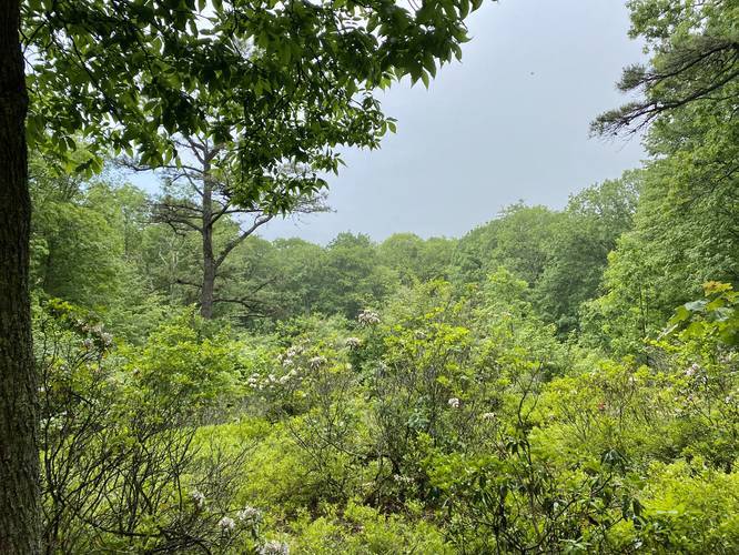
Unnamed Vista - Mile 4.68
Just before the trail really starts going downhill, and not long after leaving the grassy mountain top section, there will be a small unnamed Vista Point right off of the trail. During our visit it was raining and thus there was nothing to see at this vista except for blooming mountain laurel. When skies are clear, hikers should have views of the Wolf Run Wild Area, Bonnell Run drainage and drainages west of Pine Creek.
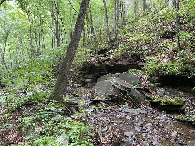
Near the bottom of this downhill section, the trail enters Wolf Run Hollow and begins running alongside Wolf Run creek. This section of the trail is by far my favorite, aside from the vistas, since you get to hike through beautiful old-growth Hemlocks and White Pines, ferns, and moss.
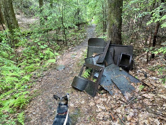
Old Stove Remains - Mile 5.54
Around mile 5.54 hikers will find the remains of an old stove, likely used by a logging camp. Please do not disturb or move these old stove pieces as this is a piece of logging history within these woods.
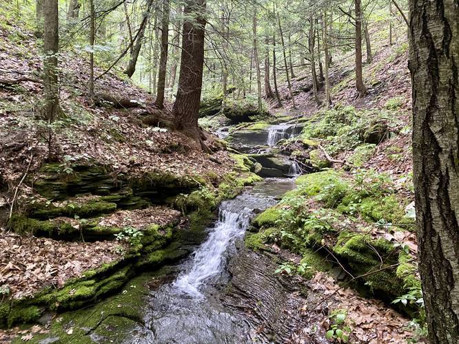
The trail will cross Wolf Run Creek about seven or eight times before the trail heads up hill runs along a hillside that has a steep grade drop-off to the to the side. Hikers will see a few small waterfall cascades within Wolf Run creek.
Old Quarry Site with Flagstone Piled - Mile 6.95
In between both waterfalls (continue reading below) lies the remains of an old quarry site. Hikers will notice the flagstone was left piled up - this was not a natural rockfall.
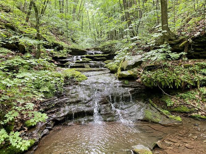
Waterfalls (Wolf Run Falls) - Mile 6.85 to 7
Around mile 6.85 hikers will cross Wolf Run creek one more time and will find a large rock grotto with boulders jutting up over the creek. Just after this rock grotto is a small two-tiered waterfall. Each tier of this waterfall is about 3-feet tall at best. After hikers visit this waterfall continue down the trail for no more than 0.2 miles and you’ll find yet another waterfall, this one is about 10 feet tall in total but has about four different tiered cascades each about 2 to 2 1/2 feet tall. Both waterfalls are unnamed, so each can be unofficially named "Wolf Run Falls", independently.
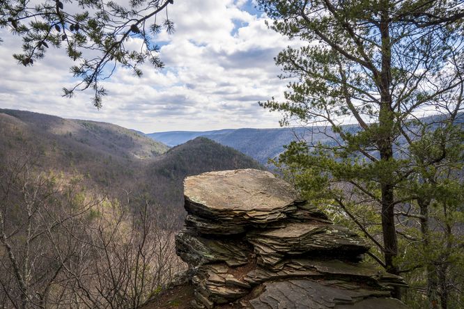
After visiting both waterfalls the trail will undulate alongside Wolf Run and then eventually level out. Not too long after the trail levels out, the Golden Eagle Trail will hit a junction with the Wolf Run Trail. Here, hikers will begin their uphill climb up the mountain towards the last two Vista Points - including Raven's Horn Vista. The uphill climb begins at approximately 7.8 miles from the trailhead and is very strenuous - following switchbacks. While hiking up the mountainside toward Raven's Horn Vista, hikers will pass several large sandstone ledges which makeup the backbone of this mountain ridge.
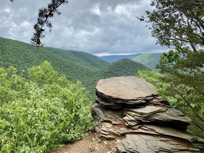
Raven's Horn Vista - Mile 8.2
Hikers will finally reach Raven's Horn Vista around mile 8.2 with breathtaking views of the Wolf Run Wild Area, Pine Creek, and the Bob Weber Trail. Hikers should be aware that the timber rattlesnake (poisonous) lives in these rocks and often can be found sunbathing on Raven's Horn Vista.
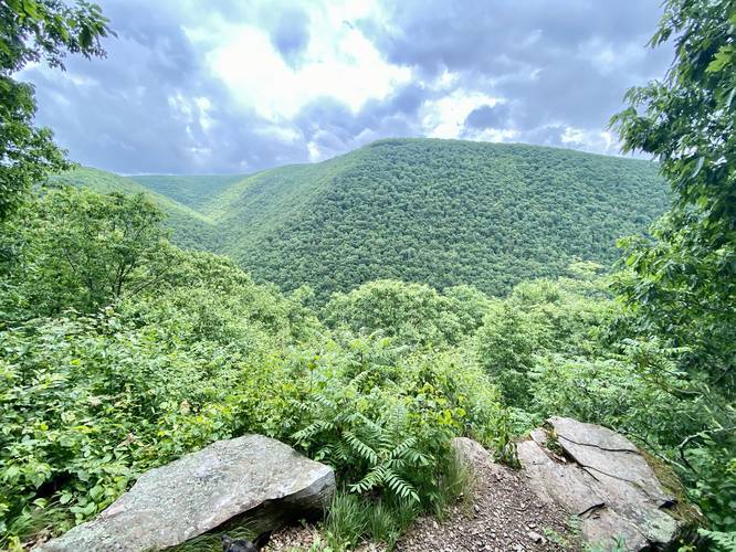
Unnamed Vista of Bob Webber Trail - Mile 8.3
After hiking uphill from Raven's Horn Vista, hikers will walk for no more than 300 feet to find a very small trail heading downhill and out to the last rocky Vista point along the Golden Eagle Trail. Directly across from this vista, on the other mountain is a view of the Wolf Run Bald Vista along the Bob Webber Trail.
After leaving the last vista, the trail will continue heading uphill for about 0.2-miles. Hikers will reach an orange blaze with a split in the trail. Take a left-hand turn at this junction to head back down to the initial spur trail and out to parking. From this left-hand turn, the entire hike back to the parking lot is downhill but a lot of it is very steep, making this downhill section difficult to hike. Along the way down, the trail will essentially perform a large switchback instead of heading directly west toward the spur trail -- this switchback includes a connection and hike along the old quarry road.
Just before leaving this section of the trail and reaching the spur trail once again, hikers will find a small view of the mountains around Pine Creek - this is named Clark's Pasture. Not long after, the Golden Eagle Trail (loop) portion will be completed and the hike out along the spur is another 0.4-miles to wrap up the 10-mile trek.
Parking
Hikers will find parking at the coordinates provided located at the Utceter Station / Clark Farm parking area for the Pine Creek Trail.
Pets
Dogs are allowed if leashed.
Camping
While this trail passes through the Wolf Run Wild Area and camping is allowed in this wild area, the terrain of the trail is so strenuous and steep in most places that camping isn't recommended. In fact the state forest asks backpackers to not camp along this trail.
Warnings (including Timber Rattlesnakes)
While the difficulty of this hike is strenuous, and "hard" at the very least, there are other warnings to note before heading out. First, Timber Rattlesnakes live near the rock ledges of Raven's Horn Vista. Between April and October, they may be found sunbathing along the rocks - keep your dogs, children, and yourself away from these poisonous snakes! You are hiking through their home. Second, poison ivy can be found alongside the trail in several places. Last, there are plenty of rock ledges near the trail that can giveaway at any time, hike at your own risk.
Trail Location
The Golden Eagle Trail technically exists within three separate 'parks': Tiadaghton State Forest, Wolf Run Wild Area (part of Tiadaghton), and finally State Game Lands 68. The northwest section, including Bonnell and Beulahland Vistas, are in State Game Lands.
What To Bring?
Trekking poles, proper footwear, plenty of water (several liters per person), physical map, and expect to get your feet wet in the creeks only if you plan to hike this trail during the early Spring when the water is flowing heavily. An offline GPS tracker (even without map tiles) is suggested for this hike to ensure you do not get lost.
Time to Hike
For an average fit individual, plan for a 6 hour hike. I (Admin) was able to complete the 10 miles in 4 hours and 17 minutes, with a ~20 minute break to wait for the rain to die down, but this was a very fast hike.
Pine Creek Pinnacles (PCP20)
This hike is part of the Pine Creek Pinnacles hiking challenge. For more information, details, and FAQs, please visit our Pine Creek Pinnacles (PCP20) page.
Trail Description
The hike begins across the street from the Utceter Station / Clark Farm parking area for the Pine Creek Trail - also where hikers can find parking. Hikers will begin by following a spur trail that leads to the Golden Eagle Trail (loop), which is a moderate uphill climb among hemlocks and moss. Hikers will find a trail registry box with a sign-in sheet within about 0.1-miles from the road - it is suggested to sign-in in case something happens to you on the trail.
At 0.4 miles the spur trail reaches a junction with the Golden Eagle Trail loop. At the junction hikers can take a right-hand turn to head towards the vistas for a shorter hike; however, reaching Raven's Horn vista is still a strenuous climb if you plan to take a right-hand turn here. This recording goes straight at the junction, following the Golden Eagle Trail in a clockwise direction, which is by far the more difficult direction to hike this trail in.
From here, the hike follows Bonnell Run creek where along the route hikers will find old growth hemlocks along the side of the trail. At 0.8 miles the trail finally heads downhill and runs directly adjacent to the creek. The first actual creek Crossing is at mile 1.6. When hiking this trail in mid June 2020, the creek bed was virtually dried up in most places. Just after the first creek crossing along Bonnell Run, hikers will enter State Game Lands number 68.
The trail will end up crossing Bonnell Run approximately twenty times in total. Around mile 3.1 the trail begins heading uphill along a very steep grade to reach the top of the mountain and northern vista points - this mountain climb is named "The Saddle". The climb up the this hill is very steep and the terrain is made up of loose rocks, which makes this section of the trail very strenuous. Once at the top, the trail will level out slightly and pass Mountain Laurel which can be found blooming in mid-June. Eventually the trail will continue heading uphill at a more gradual grade before reaching another trail junction.
At the top of the hill above Bonnell Run, hikers will reach a junction with a sign that labels the Hilborn Trail. There will be yellow blazes to your left (Dragon's Back Trail), yellow blazes straight (Hilborn Trail) and orange blazes to your right. Take a right-hand turn here to continue following the orange blazes of the Golden Eagle Trail along this wide and grassy section of trail, which looks more like a service road.
Bonnell Run Vista - Mile 3.8
At approximately mile 3.8 or slightly less, hikers will reach the Bonnell Run Vista along the mountain ridge. Just after Bonnell Run Vista the Golden Eagle Trail will take a right-hand turn once again, following a very wide trail.
Beulahland Vista - Mile 4
Not long after stopping at Bonnell Run Vista, hikers will reach the Beulahland Vista point facing north east, at approximately mile 4. The vista here has views of the Beulah Land, Oregon Hill, and southern Tioga County. Take in the views here and rest up before continuing onward.
After visiting the Beulahland Vista the trail will continue following the wide grassy mountain ridge of the Golden Eagle Trail. Off of the trail hikers will find mountain laurel, blueberries, black raspberries, and other native plants. Follow this grassy section of trail for about 0.2-miles before the Golden Eagle Trail heads back into more dense forest.
Unnamed Vista - Mile 4.68
Just before the trail really starts going downhill, and not long after leaving the grassy mountain top section, there will be a small unnamed Vista Point right off of the trail. During our visit it was raining and thus there was nothing to see at this vista except for blooming mountain laurel. When skies are clear, hikers should have views of the Wolf Run Wild Area, Bonnell Run drainage and drainages west of Pine Creek.
Near the bottom of this downhill section, the trail enters Wolf Run Hollow and begins running alongside Wolf Run creek. This section of the trail is by far my favorite, aside from the vistas, since you get to hike through beautiful old-growth Hemlocks and White Pines, ferns, and moss.
Old Stove Remains - Mile 5.54
Around mile 5.54 hikers will find the remains of an old stove, likely used by a logging camp. Please do not disturb or move these old stove pieces as this is a piece of logging history within these woods.
The trail will cross Wolf Run Creek about seven or eight times before the trail heads up hill runs along a hillside that has a steep grade drop-off to the to the side. Hikers will see a few small waterfall cascades within Wolf Run creek.
Old Quarry Site with Flagstone Piled - Mile 6.95
In between both waterfalls (continue reading below) lies the remains of an old quarry site. Hikers will notice the flagstone was left piled up - this was not a natural rockfall.
Waterfalls (Wolf Run Falls) - Mile 6.85 to 7
Around mile 6.85 hikers will cross Wolf Run creek one more time and will find a large rock grotto with boulders jutting up over the creek. Just after this rock grotto is a small two-tiered waterfall. Each tier of this waterfall is about 3-feet tall at best. After hikers visit this waterfall continue down the trail for no more than 0.2 miles and you’ll find yet another waterfall, this one is about 10 feet tall in total but has about four different tiered cascades each about 2 to 2 1/2 feet tall. Both waterfalls are unnamed, so each can be unofficially named "Wolf Run Falls", independently.
After visiting both waterfalls the trail will undulate alongside Wolf Run and then eventually level out. Not too long after the trail levels out, the Golden Eagle Trail will hit a junction with the Wolf Run Trail. Here, hikers will begin their uphill climb up the mountain towards the last two Vista Points - including Raven's Horn Vista. The uphill climb begins at approximately 7.8 miles from the trailhead and is very strenuous - following switchbacks. While hiking up the mountainside toward Raven's Horn Vista, hikers will pass several large sandstone ledges which makeup the backbone of this mountain ridge.
Raven's Horn Vista - Mile 8.2
Hikers will finally reach Raven's Horn Vista around mile 8.2 with breathtaking views of the Wolf Run Wild Area, Pine Creek, and the Bob Weber Trail. Hikers should be aware that the timber rattlesnake (poisonous) lives in these rocks and often can be found sunbathing on Raven's Horn Vista.
Unnamed Vista of Bob Webber Trail - Mile 8.3
After hiking uphill from Raven's Horn Vista, hikers will walk for no more than 300 feet to find a very small trail heading downhill and out to the last rocky Vista point along the Golden Eagle Trail. Directly across from this vista, on the other mountain is a view of the Wolf Run Bald Vista along the Bob Webber Trail.
After leaving the last vista, the trail will continue heading uphill for about 0.2-miles. Hikers will reach an orange blaze with a split in the trail. Take a left-hand turn at this junction to head back down to the initial spur trail and out to parking. From this left-hand turn, the entire hike back to the parking lot is downhill but a lot of it is very steep, making this downhill section difficult to hike. Along the way down, the trail will essentially perform a large switchback instead of heading directly west toward the spur trail -- this switchback includes a connection and hike along the old quarry road.
Just before leaving this section of the trail and reaching the spur trail once again, hikers will find a small view of the mountains around Pine Creek - this is named Clark's Pasture. Not long after, the Golden Eagle Trail (loop) portion will be completed and the hike out along the spur is another 0.4-miles to wrap up the 10-mile trek.
Parking
Hikers will find parking at the coordinates provided located at the Utceter Station / Clark Farm parking area for the Pine Creek Trail.
Pets
Dogs are allowed if leashed.
Camping
While this trail passes through the Wolf Run Wild Area and camping is allowed in this wild area, the terrain of the trail is so strenuous and steep in most places that camping isn't recommended. In fact the state forest asks backpackers to not camp along this trail.
Warnings (including Timber Rattlesnakes)
While the difficulty of this hike is strenuous, and "hard" at the very least, there are other warnings to note before heading out. First, Timber Rattlesnakes live near the rock ledges of Raven's Horn Vista. Between April and October, they may be found sunbathing along the rocks - keep your dogs, children, and yourself away from these poisonous snakes! You are hiking through their home. Second, poison ivy can be found alongside the trail in several places. Last, there are plenty of rock ledges near the trail that can giveaway at any time, hike at your own risk.
Trail Location
The Golden Eagle Trail technically exists within three separate 'parks': Tiadaghton State Forest, Wolf Run Wild Area (part of Tiadaghton), and finally State Game Lands 68. The northwest section, including Bonnell and Beulahland Vistas, are in State Game Lands.
What To Bring?
Trekking poles, proper footwear, plenty of water (several liters per person), physical map, and expect to get your feet wet in the creeks only if you plan to hike this trail during the early Spring when the water is flowing heavily. An offline GPS tracker (even without map tiles) is suggested for this hike to ensure you do not get lost.
Time to Hike
For an average fit individual, plan for a 6 hour hike. I (Admin) was able to complete the 10 miles in 4 hours and 17 minutes, with a ~20 minute break to wait for the rain to die down, but this was a very fast hike.
Pine Creek Pinnacles (PCP20)
This hike is part of the Pine Creek Pinnacles hiking challenge. For more information, details, and FAQs, please visit our Pine Creek Pinnacles (PCP20) page.