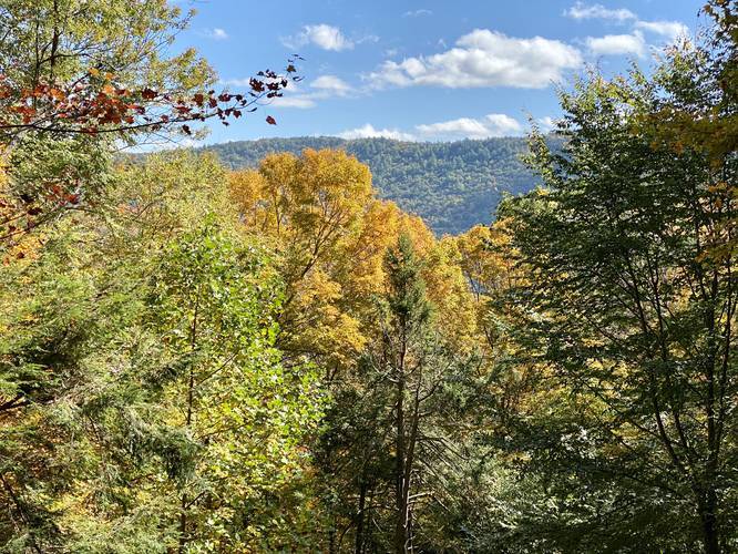
This Hemlock Mountain Loop hike at Tiadaghton State Forest near Slate Run, Pennsylvania is a strenuous 5.4-mile loop that brings hikers to the summit of Hemlock Mountain and features stunning views of Pine Creek, Wolf Run Wild Area, and Half Dome Mountain.
Trails
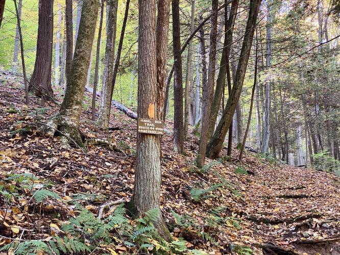
This hike follows several name trails: Naval Run Trail (yellow blaze), Black Forest Trail (orange blaze), and the Lance Raisch Trail (yellow blaze).
Trail Description
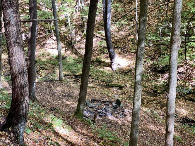
This hike begins at the small parking area at the end of Naval Run Road in Slate Run, PA. Hikers will follow a small trail that leads down and across Naval Run, where the loop begins. Here, the easiest route to follow (and the route in this GPX track) takes a right-hand turn just after the creek crossing to hike uphill adjacent to Naval Run creek and along the Naval Run Trail.
As hikers make their way up the Naval Run Trail, they may notice some seasonal waterfalls in Naval Run creek below. Most of these waterfalls are dried up by mid-June; however, some may still be trickling during the Summer and Autumn. Naval Run Falls, the largest of the waterfalls, can be found at the Black Forest Trail junction where the yellow blazes of the Naval Run Trail meet the Black Forest Trail.
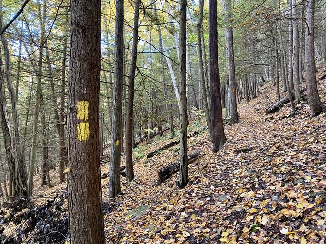
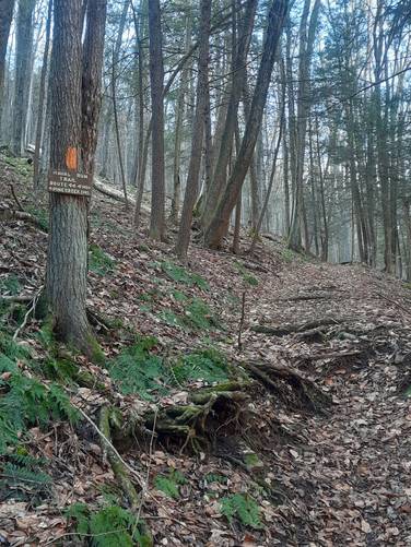
After hiking up along the Naval Run Trail for about 1-mile, the trail will finally take a left-hand turn, following the Black Forest Trail's orange blazes, up the steeper section of Hemlock Mountain. Here is where the real climb begins.
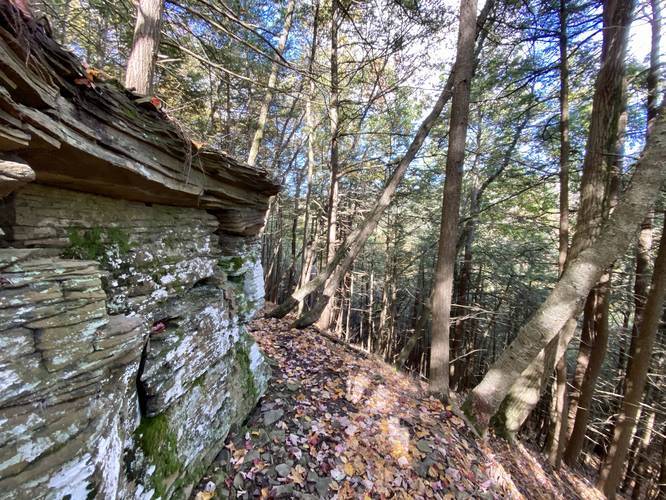
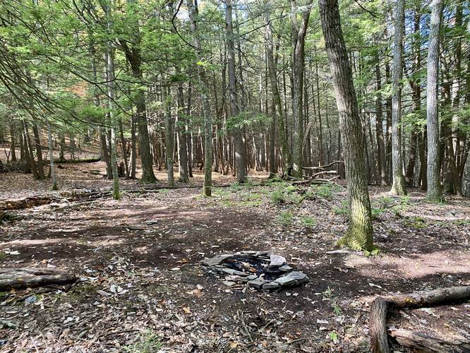
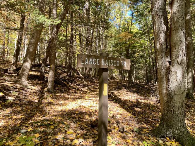
The trail will head up the steep Hemlock Mountain along several switchbacks to reach the summit. On the way, hikers will pass the yellow blaze trailhead for the Lance Raisch Trail (no trailhead sign as of Oct 6, 2020), a rocky outcropping, and a campsite. When you reach the rocky outcropping - requiring a bit more effort to climb up - you may think you're just below the summit, but this section of trail is perfect to note that you are at a false summit instead.
Just after the rocky outcropping, the trail will pass a campsite along flat ground. The trail will meander its way back uphill to reach the first vista point, just below the summit.
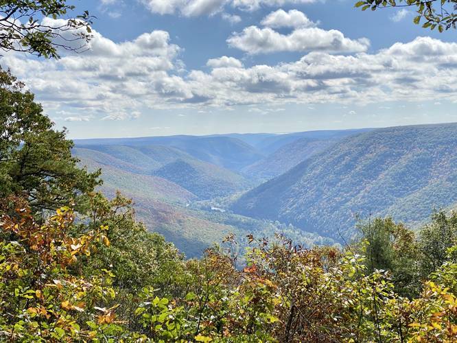
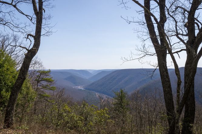
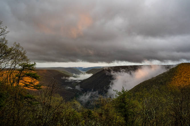
Below Summit Vista - Pine Creek (facing northeast)
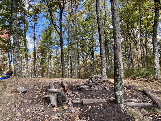
Hikers will reach the first vista around mile 2.5. Here, you can take in the views of Pine Creek and the surrounding mountains. As of October 6, 2020, there was a small firepit located at this overlook, but there is no campsite next to it. For a true campsite, hikers and backpackers will want to head to the 2nd vista, at the summit.
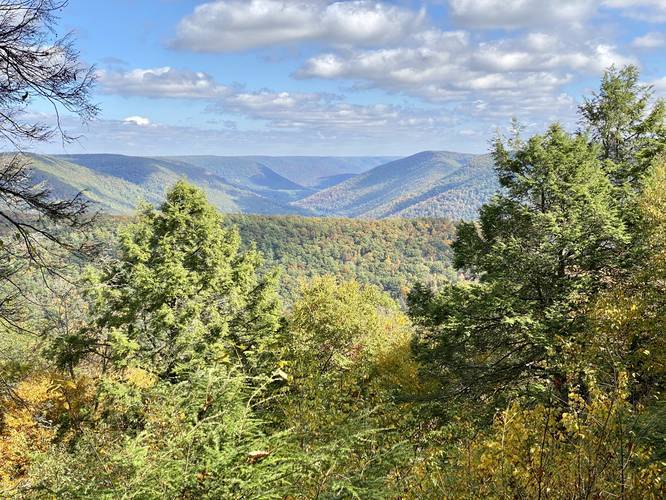
Hemlock Mountain Summit Vista / Overlook
Finally, at mile 2.6 hikers will reach the true summit of Hemlock Mountain. Here, the summit features a campsite and a beautiful overlook of Pine Creek. Hikers with some knowledge of the area will notice the Wolf Run Wild Area to the left-hand side of Pine Creek - where the Bob Webber Trail ascends the mountains. They may also notice Half Dome Mountain immediately next to Hemlock Mountain to the right-hand side too.
Finishing the Loop
After visiting the vistas (or camping out here), the hike back along this loop is fairly straight forward, with the exception that the Lance Raisch Trail has a semi-unmaintained section which is odd to follow. From the summit, head back down the Black Forest Trail the way you came up Hemlock Mountain and look for the Lance Raisch Trail's yellow blazes on your right-hand side.
Once on the Lance Raisch Trail (as of October 6, 2020), hikers will follow the very-skinny yellow blazed path that barely cuts through the woods. At times you may be searching for blazes, but your best bet is to look for a path that deer would follow, and hike it. Eventually the trail will reach a wider path along a clear yellow-blazed trail. This section appears to be an old log slide or potentially a service road. Either way, the western section of the Lance Raisch Trail is sketchy at best, but hike-able.
Lance Raisch Vista
Hikers will reach one more vista point before hiking out. This overlook is along the Lance Raisch Trail around mile 3.9. The view is not the best, but it's a great place to take a break along the slopes of Hemlock Mountain.
After taking in the small vista along the Lance Raisch Trail, the trail will slowly meander its way along the eastern slopes of Hemlock Mountain before reaching the Pine Trail. Here, hikers will take a left-hand turn along the Pine Trail to then reach the Naval Run creek crossing once again. Cross Naval Run creek to reach the parking area to wrap up the hike.
Blaze Colors
This hike follows yellow and orange blazes. The only orange-blazed trail is the Black Forest Trail.
Parking
Hikers will find a small parking turnout at the end of Naval Run Road. The parking area is only large enough for about 5 vehicles max.
Pets
Dogs are allowed if leashed.
Camping and Backpacking
Backpackers will find plenty of campsites along this section of the Black Forest Trail, mainly. Other campsites can be found in the area especially along the Pine Trail (see our PA Half Dome guide) for those campsite locations.
Pine Creek Pinnacles (PCP20)
This hike is part of the Pine Creek Pinnacles hiking challenge. For more information, details, and FAQs, please visit our Pine Creek Pinnacles (PCP20) page.
Trails
This hike follows several name trails: Naval Run Trail (yellow blaze), Black Forest Trail (orange blaze), and the Lance Raisch Trail (yellow blaze).
Trail Description
This hike begins at the small parking area at the end of Naval Run Road in Slate Run, PA. Hikers will follow a small trail that leads down and across Naval Run, where the loop begins. Here, the easiest route to follow (and the route in this GPX track) takes a right-hand turn just after the creek crossing to hike uphill adjacent to Naval Run creek and along the Naval Run Trail.
As hikers make their way up the Naval Run Trail, they may notice some seasonal waterfalls in Naval Run creek below. Most of these waterfalls are dried up by mid-June; however, some may still be trickling during the Summer and Autumn. Naval Run Falls, the largest of the waterfalls, can be found at the Black Forest Trail junction where the yellow blazes of the Naval Run Trail meet the Black Forest Trail.
After hiking up along the Naval Run Trail for about 1-mile, the trail will finally take a left-hand turn, following the Black Forest Trail's orange blazes, up the steeper section of Hemlock Mountain. Here is where the real climb begins.
The trail will head up the steep Hemlock Mountain along several switchbacks to reach the summit. On the way, hikers will pass the yellow blaze trailhead for the Lance Raisch Trail (no trailhead sign as of Oct 6, 2020), a rocky outcropping, and a campsite. When you reach the rocky outcropping - requiring a bit more effort to climb up - you may think you're just below the summit, but this section of trail is perfect to note that you are at a false summit instead.
Just after the rocky outcropping, the trail will pass a campsite along flat ground. The trail will meander its way back uphill to reach the first vista point, just below the summit.
Below Summit Vista - Pine Creek (facing northeast)
Hikers will reach the first vista around mile 2.5. Here, you can take in the views of Pine Creek and the surrounding mountains. As of October 6, 2020, there was a small firepit located at this overlook, but there is no campsite next to it. For a true campsite, hikers and backpackers will want to head to the 2nd vista, at the summit.
Hemlock Mountain Summit Vista / Overlook
Finally, at mile 2.6 hikers will reach the true summit of Hemlock Mountain. Here, the summit features a campsite and a beautiful overlook of Pine Creek. Hikers with some knowledge of the area will notice the Wolf Run Wild Area to the left-hand side of Pine Creek - where the Bob Webber Trail ascends the mountains. They may also notice Half Dome Mountain immediately next to Hemlock Mountain to the right-hand side too.
Finishing the Loop
After visiting the vistas (or camping out here), the hike back along this loop is fairly straight forward, with the exception that the Lance Raisch Trail has a semi-unmaintained section which is odd to follow. From the summit, head back down the Black Forest Trail the way you came up Hemlock Mountain and look for the Lance Raisch Trail's yellow blazes on your right-hand side.
Once on the Lance Raisch Trail (as of October 6, 2020), hikers will follow the very-skinny yellow blazed path that barely cuts through the woods. At times you may be searching for blazes, but your best bet is to look for a path that deer would follow, and hike it. Eventually the trail will reach a wider path along a clear yellow-blazed trail. This section appears to be an old log slide or potentially a service road. Either way, the western section of the Lance Raisch Trail is sketchy at best, but hike-able.
Lance Raisch Vista
Hikers will reach one more vista point before hiking out. This overlook is along the Lance Raisch Trail around mile 3.9. The view is not the best, but it's a great place to take a break along the slopes of Hemlock Mountain.
After taking in the small vista along the Lance Raisch Trail, the trail will slowly meander its way along the eastern slopes of Hemlock Mountain before reaching the Pine Trail. Here, hikers will take a left-hand turn along the Pine Trail to then reach the Naval Run creek crossing once again. Cross Naval Run creek to reach the parking area to wrap up the hike.
Blaze Colors
This hike follows yellow and orange blazes. The only orange-blazed trail is the Black Forest Trail.
Parking
Hikers will find a small parking turnout at the end of Naval Run Road. The parking area is only large enough for about 5 vehicles max.
Pets
Dogs are allowed if leashed.
Camping and Backpacking
Backpackers will find plenty of campsites along this section of the Black Forest Trail, mainly. Other campsites can be found in the area especially along the Pine Trail (see our PA Half Dome guide) for those campsite locations.
Pine Creek Pinnacles (PCP20)
This hike is part of the Pine Creek Pinnacles hiking challenge. For more information, details, and FAQs, please visit our Pine Creek Pinnacles (PCP20) page.