The PA Half Dome hike at Tiadaghton State Forest near Slate Run, Pennsylvania is a strenuous 4.3-mile out-and-back hike that leads to two stunning vista points atop Half Dome Mountain with views of Pine Creek and the Wolf Run Wild Area.
For a more challenging hike to Half Dome Mountain's summit, experienced hikers can also try the grueling 2,600-foot elevation gain, 3.4-mile out-and-back PA Half Dome - South Ascent for an alternative route.
Trails
This hike follows three named trails: Naval Run Trail, Pine Trail, Half Dome Mountain Trail (Half Dome Trail). All of these trails follow yellow blazes.
Trail Description
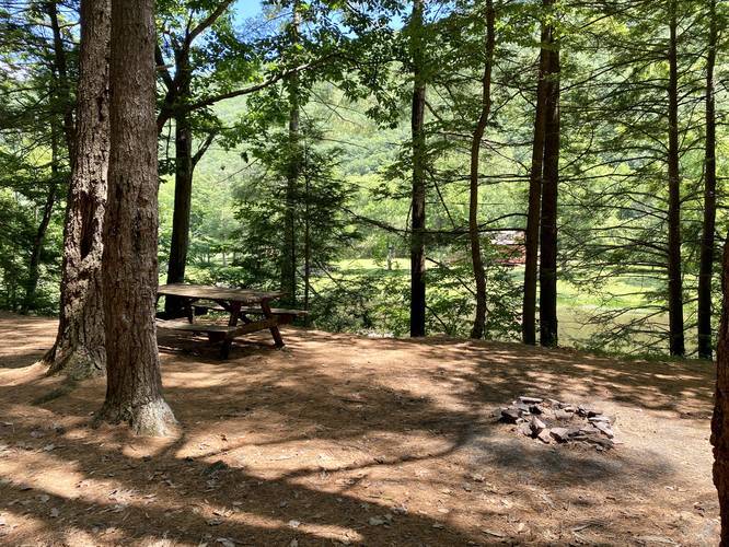
The hike starts at the Naval Run Trail trailhead, just behind the parking area and a small campsite with a picnic table. The Naval Run Trail follows a large ravine high above Naval Run creek for about 1/10 of a mile before reaching a creek crossing over Naval Run. After crossing Naval Run, take a left-hand turn to follow the Pine Trail.
The trail leads uphill along a high and steep ravine hillside above Naval Run as it heads east back towards Pine Creek. Right where the trail turns right - heading southward, the trail splits and heads to a nice campsite underneath a beautiful conifer grove. After the trail turns south heading along Pine Creek hikers will pass through coniferous groves of White Pines and Hemlocks - some of which are old growth trees.
At mile 0.5 hikers will reach the Lance Raisch Trail on your right-hand side – hike straight at this junction to continue along the Pine Trail. Not long after walking through the coniferous forest, the trail will cross one more creek around mile 0.85 - Callahan Run. Just after crossing Callahan Run creek, the trail will head uphill and there will be a campsite at the top of the small hill. About 150 feet after the campsite the trail head uphill again and eventually hit a left-hand turn - this turn is not easy to see, so be on the lookout for it. As long as you do not hike up the Callahan Run ravine too far, you have taken the proper turn headed towards the Pennsylvania Half Dome.
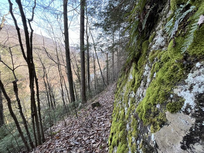
Eventually, the trail starts heading uphill more along a very steep hillside, however the trail's elevation grade is moderate. The Pine Trail will follow this very steep hillside for quite a long time while passing large cliff ledges. The trail in this section is very sketchy since the width of the trail itself is about 12-inches wide at best, with loose footing and plenty of places to fall and tumble down the steep hillside.
Reaching the Half Dome Trail
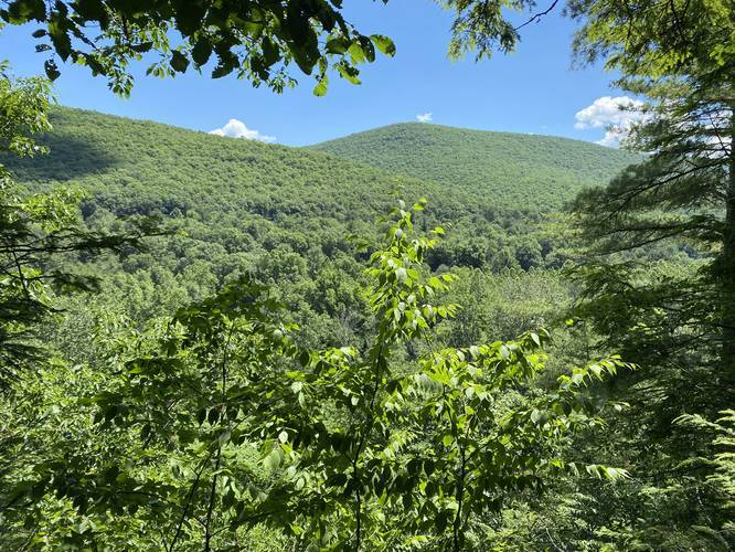
Finally around mile 1.53, hikers will reach the Half Dome Mountain climbing route. Right after beginning the ascent up Half Dome Mountain, hikers will find a vista point about 10 feet above the Half Dome trailhead. This vista looks directly into the Wolf Run Wild Area with a view of the Golden Eagle Trail the Bob Webber Trail's vista point -- Wolf Run Bald Vista.
From here, the climb to the top of Half Dome Mountain is extremely steep, dangerous, and difficult for approximately 1,300-feet in just 0.5 miles. Hikers must bring trekking poles and proper footwear on this hike to ensure your safety while ascending and descending the mountain. Along the way up, hikers will find the mountain is made up of plenty of sandstone ledges that makeup this mountain's backbone ridge. Some of these sandstone ledges make it easier or harder to hike up or down the mountain along this section of the trail.
Half Dome Vistas - North and South
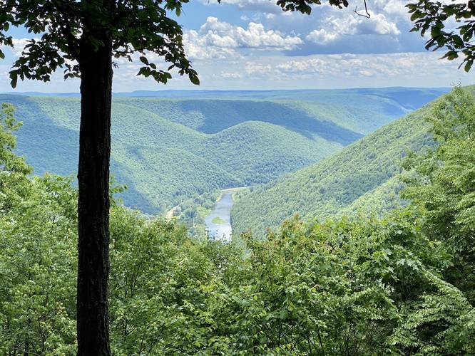
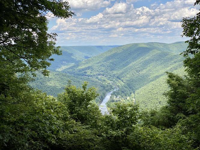
Eventually hikers will reach the top of Half Dome Mountain after battling the insane climb up. The first vista (Half Dome South Vista) can be found on the trail to the south side of Half Dome Mountain. This vista gives hikers a view of Pine Creek - looking south - and mountains in the distance. If you look to your left, you can find the Bob Webber Trail and Golden Eagle Trail locations with in the Wolf Run Wild Area. Next, continue hiking along the yellow blazes north for about 100-feet to find the Half Dome North Vista that has stunning views of Pine Creek, Slate Run, and the Wolf Run Wild Area looking North.
Descending Half Dome Mountain
After taking in the beautiful views from both of Half Dome Mountain's vistas, the hike downhill is noteworthy because of its difficulty and danger. The climb up took 50 minutes to hike about 0.5 miles one-way and while the downhill hike takes about 30 minutes, it's far more dangerous because of the fall factor. The trail is extremely steep in various places along this mountain climb and I personally (Admin) slipped twice - one time I lost friction and slid down the mountain for about 10-feet before stopping. Luckily I had been bracing for a fall and was already low to the ground, nearly sitting on my butt while making my way down the mountain. Hikers must not underestimate the sheer difficulty of hiking up or down Half Dome Mountain - please bring the proper footwear and trekking poles or else this hike is impossible.
Finally, after descending Half Dome Mountain, hikers have to brave the sketchy, steep, and narrow trail of the Pine Trail as it skirts its way around the eastern side of Half Dome Mountain. After the sketchy section of the Pine Trail is over, the hike becomes far less dangerous and much more easy on the way back to parking.
Parking
Hikers can find parking at the coordinates provided. The lot is very small and can hold about 5 cars total. Please note that the parking area is located next to two drive-in campsites.
Pets
Dogs are allowed if leashed. For this hike, it's probably best to leave your dog at home.
Camping and Backpacking
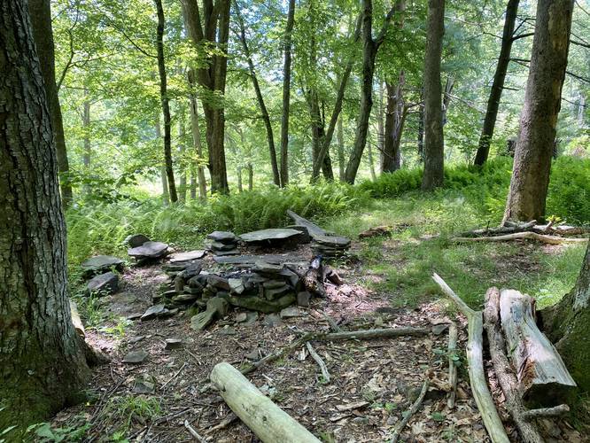
Please follow the Tiadaghton State Forest rules and regulations regarding primitive / backcountry / dispersed camping. Two designated campsites can be found along this trail near mile 0.25 and mile 0.85.
Warnings
Hikers should note the steep elevation grade of the Half Dome Mountain trail and the steep hillside and narrow trail along the Pine Trail near Half Dome Mountain. The climb up Half Dome Mountain is approximately 1,300-feet in just 0.5-miles, excluding the difficult hike down. Also note that the Timber Rattlesnake lives within the rocks of these mountains - watch your step as this is their home. You may find rattlesnakes sunbathing on rocks.
Extremely-steep Terrain: Once on Half Dome Mountain, hikers will be faced with extremely-steep terrain where the soil can become loose. When this happens, the mountain tends to send hikers down its slopes. This is no joke and should not be taken lightly, as on this hike, one person did get slightly injured. In fact, we both slid down the mountain for at least 10-feet. This is the same experience I had when initially hiking Half Dome Mountain - gravity will overtake the friction of your boots, thus, it's best to sit on your butt and anticipate the slides on the steepest sections while heading downhill.
Loose, Falling Rocks: Half Dome Mountain has several rock scrambles that are essentially made from slate or shale rock. This can be dangerous because you can accidentally send large chunks of rock down the mountain, potentially heading toward your hiking group. This could also cause you to fall down the mountain with the rock. For this reason, only experienced hikers with scrambling experience should attempt this hike.
Trekking Poles: Hikers should always bring trekking poles for this hike to aid in ascent and descent. Trekking poles may even save yourself from injury due to the insanely-steep terrain.
Avoid Group Hikes: Due to the extremely-steep terrain, it's best to avoid group hikes on this mountain. You never know when you might accidentally send a large chunk of rock down the mountain or accidentally lose your friction and slide into the group behind you. One false move could mean injuries for not just you, but your hiking group. If not hiking solo, it's best to spread your group out while ascending and descending the mountain.
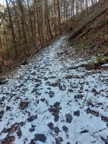
Winter Ascents: Only experienced hikers with proper with gear should attempt this hike when snow and ice are on the ground. Waterproof boots, pants, jacket, ice axe, crampons, layering, and emergency backup gear like a mylar blanket and air-activated hand-warmers are all recommended if attempting this hike in the winter.
Pine Creek Pinnacles (PCP20)
This hike is part of the Pine Creek Pinnacles hiking challenge. For more information, details, and FAQs, please visit our Pine Creek Pinnacles (PCP20) page.
For a more challenging hike to Half Dome Mountain's summit, experienced hikers can also try the grueling 2,600-foot elevation gain, 3.4-mile out-and-back PA Half Dome - South Ascent for an alternative route.
Trails
This hike follows three named trails: Naval Run Trail, Pine Trail, Half Dome Mountain Trail (Half Dome Trail). All of these trails follow yellow blazes.
Trail Description
The hike starts at the Naval Run Trail trailhead, just behind the parking area and a small campsite with a picnic table. The Naval Run Trail follows a large ravine high above Naval Run creek for about 1/10 of a mile before reaching a creek crossing over Naval Run. After crossing Naval Run, take a left-hand turn to follow the Pine Trail.
The trail leads uphill along a high and steep ravine hillside above Naval Run as it heads east back towards Pine Creek. Right where the trail turns right - heading southward, the trail splits and heads to a nice campsite underneath a beautiful conifer grove. After the trail turns south heading along Pine Creek hikers will pass through coniferous groves of White Pines and Hemlocks - some of which are old growth trees.
At mile 0.5 hikers will reach the Lance Raisch Trail on your right-hand side – hike straight at this junction to continue along the Pine Trail. Not long after walking through the coniferous forest, the trail will cross one more creek around mile 0.85 - Callahan Run. Just after crossing Callahan Run creek, the trail will head uphill and there will be a campsite at the top of the small hill. About 150 feet after the campsite the trail head uphill again and eventually hit a left-hand turn - this turn is not easy to see, so be on the lookout for it. As long as you do not hike up the Callahan Run ravine too far, you have taken the proper turn headed towards the Pennsylvania Half Dome.
Eventually, the trail starts heading uphill more along a very steep hillside, however the trail's elevation grade is moderate. The Pine Trail will follow this very steep hillside for quite a long time while passing large cliff ledges. The trail in this section is very sketchy since the width of the trail itself is about 12-inches wide at best, with loose footing and plenty of places to fall and tumble down the steep hillside.
Reaching the Half Dome Trail
Finally around mile 1.53, hikers will reach the Half Dome Mountain climbing route. Right after beginning the ascent up Half Dome Mountain, hikers will find a vista point about 10 feet above the Half Dome trailhead. This vista looks directly into the Wolf Run Wild Area with a view of the Golden Eagle Trail the Bob Webber Trail's vista point -- Wolf Run Bald Vista.
From here, the climb to the top of Half Dome Mountain is extremely steep, dangerous, and difficult for approximately 1,300-feet in just 0.5 miles. Hikers must bring trekking poles and proper footwear on this hike to ensure your safety while ascending and descending the mountain. Along the way up, hikers will find the mountain is made up of plenty of sandstone ledges that makeup this mountain's backbone ridge. Some of these sandstone ledges make it easier or harder to hike up or down the mountain along this section of the trail.
Half Dome Vistas - North and South
Eventually hikers will reach the top of Half Dome Mountain after battling the insane climb up. The first vista (Half Dome South Vista) can be found on the trail to the south side of Half Dome Mountain. This vista gives hikers a view of Pine Creek - looking south - and mountains in the distance. If you look to your left, you can find the Bob Webber Trail and Golden Eagle Trail locations with in the Wolf Run Wild Area. Next, continue hiking along the yellow blazes north for about 100-feet to find the Half Dome North Vista that has stunning views of Pine Creek, Slate Run, and the Wolf Run Wild Area looking North.
Descending Half Dome Mountain
After taking in the beautiful views from both of Half Dome Mountain's vistas, the hike downhill is noteworthy because of its difficulty and danger. The climb up took 50 minutes to hike about 0.5 miles one-way and while the downhill hike takes about 30 minutes, it's far more dangerous because of the fall factor. The trail is extremely steep in various places along this mountain climb and I personally (Admin) slipped twice - one time I lost friction and slid down the mountain for about 10-feet before stopping. Luckily I had been bracing for a fall and was already low to the ground, nearly sitting on my butt while making my way down the mountain. Hikers must not underestimate the sheer difficulty of hiking up or down Half Dome Mountain - please bring the proper footwear and trekking poles or else this hike is impossible.
Finally, after descending Half Dome Mountain, hikers have to brave the sketchy, steep, and narrow trail of the Pine Trail as it skirts its way around the eastern side of Half Dome Mountain. After the sketchy section of the Pine Trail is over, the hike becomes far less dangerous and much more easy on the way back to parking.
Parking
Hikers can find parking at the coordinates provided. The lot is very small and can hold about 5 cars total. Please note that the parking area is located next to two drive-in campsites.
Pets
Dogs are allowed if leashed. For this hike, it's probably best to leave your dog at home.
Camping and Backpacking
Please follow the Tiadaghton State Forest rules and regulations regarding primitive / backcountry / dispersed camping. Two designated campsites can be found along this trail near mile 0.25 and mile 0.85.
Warnings
Hikers should note the steep elevation grade of the Half Dome Mountain trail and the steep hillside and narrow trail along the Pine Trail near Half Dome Mountain. The climb up Half Dome Mountain is approximately 1,300-feet in just 0.5-miles, excluding the difficult hike down. Also note that the Timber Rattlesnake lives within the rocks of these mountains - watch your step as this is their home. You may find rattlesnakes sunbathing on rocks.
Extremely-steep Terrain: Once on Half Dome Mountain, hikers will be faced with extremely-steep terrain where the soil can become loose. When this happens, the mountain tends to send hikers down its slopes. This is no joke and should not be taken lightly, as on this hike, one person did get slightly injured. In fact, we both slid down the mountain for at least 10-feet. This is the same experience I had when initially hiking Half Dome Mountain - gravity will overtake the friction of your boots, thus, it's best to sit on your butt and anticipate the slides on the steepest sections while heading downhill.
Loose, Falling Rocks: Half Dome Mountain has several rock scrambles that are essentially made from slate or shale rock. This can be dangerous because you can accidentally send large chunks of rock down the mountain, potentially heading toward your hiking group. This could also cause you to fall down the mountain with the rock. For this reason, only experienced hikers with scrambling experience should attempt this hike.
Trekking Poles: Hikers should always bring trekking poles for this hike to aid in ascent and descent. Trekking poles may even save yourself from injury due to the insanely-steep terrain.
Avoid Group Hikes: Due to the extremely-steep terrain, it's best to avoid group hikes on this mountain. You never know when you might accidentally send a large chunk of rock down the mountain or accidentally lose your friction and slide into the group behind you. One false move could mean injuries for not just you, but your hiking group. If not hiking solo, it's best to spread your group out while ascending and descending the mountain.
Winter Ascents: Only experienced hikers with proper with gear should attempt this hike when snow and ice are on the ground. Waterproof boots, pants, jacket, ice axe, crampons, layering, and emergency backup gear like a mylar blanket and air-activated hand-warmers are all recommended if attempting this hike in the winter.
Pine Creek Pinnacles (PCP20)
This hike is part of the Pine Creek Pinnacles hiking challenge. For more information, details, and FAQs, please visit our Pine Creek Pinnacles (PCP20) page.