1.7 mi Easy Out-and-Back Add to Trailmix: Log in to create a Trailmix What are Trailmixes? Bears Den Overlook Hike Bluemont, Virginia 3.67
7.1 mi Moderate Out-and-Back Add to Trailmix: Log in to create a Trailmix What are Trailmixes? Annapolis Rock and Black Rock Cliff Hike Myersville, Maryland 3.46
10.0 mi Hard Loop Add to Trailmix: Log in to create a Trailmix What are Trailmixes? Old Rag Mountain Hike Sperryville, Virginia 4.66
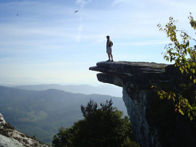
7.9 mi Moderate Loop Add to Trailmix: Log in to create a Trailmix What are Trailmixes? McAfee Knob Hike Salem, Virginia 4.48
19.6 mi Moderate Loop Add to Trailmix: Log in to create a Trailmix What are Trailmixes? Dolly Sods Lions Head Hike Dolly Sods Wilderness, West Virginia 4.5
10.0 mi Hard Loop Add to Trailmix: Log in to create a Trailmix What are Trailmixes? Signal Knob Hike Fort Valley, Virginia 3.82
13.2 mi Strenuous Loop Add to Trailmix: Log in to create a Trailmix What are Trailmixes? Three Ridges Hike White Rock, Virginia 4.3
15.0 mi Moderate Out-and-Back Add to Trailmix: Log in to create a Trailmix What are Trailmixes? Spruce Knob and Seneca Creek Hike Riverton, West Virginia 4.67
4.1 mi Hard Loop Add to Trailmix: Log in to create a Trailmix What are Trailmixes? Humpback Rocks Hike Afton, Virginia 3.91
6.8 mi Moderate Out-and-Back Add to Trailmix: Log in to create a Trailmix What are Trailmixes? Kennedy Peak Hike Luray, Virginia 3.82
1.7 mi Easy Out-and-Back Add to Trailmix: Log in to create a Trailmix What are Trailmixes? Huckleberry Knob Hike Lake Santeetlah, North Carolina 0
4.7 mi Hard Loop Add to Trailmix: Log in to create a Trailmix What are Trailmixes? Dragon's Tooth Hike Catawba, Virginia 4.39