Loading...

🔥 End of Summer sale! 50% off on Supporter Accounts — now through September 1st. Learn More.

Spruce Knob and Seneca Creek Hike

Directions
Map
Pictures
Send to App
Distance:
15.0 Miles / 24.1 km
Type:
Out-and-Back
Difficulty:
Moderate
Time to Hike:
7 hours, ~30 minutes
Features:
Surface Type:
Dirt
Park:
Monongahela National Forest
Town:
Riverton, West Virginia
Directions:
38.7023, -79.53105
Added:
March 16, 2025
Updated:
April 05, 2025
Guide by:
Copy Trail Link Hiking this trail? Send a friend or family member a link to this trail guide for your own safety. Hike at your own risk (disclaimer)
Loading...
Loading...
1,700'

Total Change
2,247'

Ascent
2,259'

Descent

Download the Trail Route for Offline Use

Supporters get exclusive access to download trail routes to the MyHikes app for offline use. Stay prepared on your adventure, even without an internet connection! Become a Supporter today to unlock this feature and hike with confidence.

Send to App

Spruce Knob and Seneca Creek Hike

Easily in the top 5 backpacking routes in the mid-Atlantic. The Spruce Knob/Seneca Creek circuit has beautiful meadows, mountain vistas, waterfalls, and the best camping to be found. Starting at Spruce Knob, the tallest peak in West Virginia, the hike also has a short 1/2 mile circuit at the summit with beautiful panoramic and views of the valley.

The best time of year to enjoy this hike is July-September when the temps are almost spring like at these 5K foot altitudes. If you hike this circuit in September, you'll also get to enjoy the fields of blackberries on the High Meadows Trail.

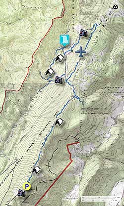
  • Mile 0.0 – Start at the Spruce Knob parking area heading down the Huckleberry Trail TR533. In the first 2.0 miles, the trail passes a number of nice campsites located under canopies of Spruce. The trail will then open up passing through several small meadows before descending to another campsite where the trail makes a sharp right. Follow the trail for another 0.2 miles and turn left, followed shortly by another left. At this point the Huckleberry Trail crosses through one more small meadow then begins a steep descent to the intersection of the four way intersection with the Lumberjack Trail.
  • Mile 4.7 - Turn right on the Lumberjack Trail TR534. The Lumberjack Trail is an old forestry road with poor drainage, very muddy, and can take some time to navigate depending on the conditions. At 1.0 miles on the Lumberjack Trail is the wreckage of a Piper PA-23 that crashed in 1973 with the loss of 2 souls. The wreck site (video) is located 75 yards below the trail at N38.76409 W79.49852. If you decide to visit the site please do not disturb any of the wreckage out of respect for the lives lost here. Continue on the trail for another mile reaching the intersection of the High Meadows Trail. The unmaintained portion of the Lumberjack Trail veers right uphill, and the High Meadows Trail veers left.
  • Mile 6.7 - Veer left onto the High Meadows Trail TR564. The trail will soon make a left and descend towards the meadows. Be careful as the High Meadows Trail is inundated with stinging nettles. After entering the first meadow look for the trail marker directly on the opposite side of the meadow. Here you will pass through the thickest blackberry section. Re-enter the forest before once again passing through the last of the mountain meadows on the trail. At the end of the second large meadow cross a small creek and arrive at the intersection of the Horton Trail and end of the High Meadows Trail.
  • Mile 8.6 - Turn right downhill on the Horton Trail TR530 for 0.5 miles where the Horton Trail joins the Seneca Creek Trail TR515.
  • Mile 9.1 - Turn right downstream on the Seneca Creek Trail for 75 yards to view Seneca Falls (video). Now return up up the Seneca Creek Trail passing the Horton Trail you just descended, then cross Seneca Creek for the first time. Pass the first of many wonderful campsites (video). Follow the Seneca Creek Trail crossing Seneca Creek two more times, pass the Bear Hunter Trail, and reach the meadow at Judy Springs. Note: 0.2 miles before reaching Judy Springs is the prettiest campsite in the Monongahela. This campsite is on the banks of Seneca Creek with a waterfall directly across from it. Don't worry if it's occupied, every campsite on Seneca Creek is excellent!
  • Mile 10.9 - At Judy Springs turn left crossing a wooden footbridge over Seneca Creek onto the Judy Springs Trail TR512, then begin the steepest section of the hike climbing back up Spruce Mountain. After 0.3 the Judy Springs Trail passes through the largest of the mountain meadows with a panoramic view back towards Seneca Creek. The trail will then renter the forest at the top of the meadow ending at the intersection of the Horton Trail.
  • Mile 11.6 - Turn right uphill on the Horton Trail TR530. Soon pass a vista through a gap in the trees, and continue for another 0.2 mile where the Horton Trail reaches the intersection of the Lumberjack Trail you took earlier.
  • Mile 11.8 - Continue uphill on the Huckleberry Trail retracing your steps the 4.7 miles back to the hike start point.
  • Mile 15.0 - Arrive back at the parking area on Spruce Knob.
Explore 63 trails near Riverton, WV
  1. Parking

    38.7023, -79.53105
  2. Main Trailhead

    38.702458, -79.531059
No community routes found. To add your own hike as a Community Route for this Trail guide, leave a Trip Report with an attached GPX file.

Hazards

Ticks - Lyme Disease More Info (CDC)
Snakes
Poison Ivy/Oak

Seasons

All

Trip Reports (Reviews)

Rated 4.66 out of 5 based on 41 ratings.
By: Wolly and friends
15.0 miles / 24.1 km
July 12, 2019
Awesome hike( my favorite now), it rained the previous two days making the trail difficult at times but manageable with a good pair of waterproof boots. We arrived in the valley later in the day and had difficulty finding a camping site as most were already filled. The Seneca Creek was beautiful, the mountain laurel was in full bloom, the entire hillside was covered in flowers almost making it look We didnt have any issues with bugs or mosquitoes.light lightening bugs. There were waterfalls everywhere you looked , including one cascading down a flat rock. We swam below the largest waterfall, the water was cold but very refreshing, the creek was running strong making the falls looks spectacular. You need to do this hike at least once in your lifetime.
Legacy Review
By: John
15.0 miles / 24.1 km
October 05, 2018
Great hike but it was quite muddy at some points (mostly on Lumberjack Trail).
Legacy Review
By: DB
15.0 miles / 24.1 km
September 29, 2018
Overall a great hike! I understand why people say it is one of the best in the area for the diversity. It starts with wide panoramas at the lookout by the parking lot, then goes to thick moss covered forests, mountain meadows, and then river hiking and water crossings. This could be made into a 2-3 day hike. Of note, the first 5-6 miles on the lumberjack trail do not have scenic views except for the lookout at the parking lot at Spruce knob. I didn't realize this before starting. If you wanted to make the hike shorter, it looks like there is a road that meets up with the huckleberry trail a few miles in. This would probably but out 3-4 miles each way (didn't get the exact distances). You would miss the panoramic views at the Spruce Knob parking lot though, but you would still get the mountain meadows on High Meadows Trail/Judy Springs Trail and the river views on Seneca River Trails.
Legacy Review

Weather Forecast

In Riverton, WV

Explore Hiking Trails

You May Also Like

Colorado's Million Dollar Highway - Plan a day's drive adventure along the iconic Million Dollar Highway in Colorado. Explore the best short trails, roadside stops, waterfalls, vistas, ghost towns, and hot springs within a ~6 hour road trip.
Explore

Colorado's Million Dollar Highway

Plan a day's drive adventure along the iconic Million Dollar Highway in Colorado. Explore the best short trails, roadside stops, waterfalls, vistas, ghost towns, and hot springs within a ~6 hour road trip.

Read
New York's Best Waterfalls - Whether you're planning a day hike, roadside stop, or a leisurely short walk, this guide provides hikers, travelers, and locals alike with 63 different locations to over 100 scenic waterfalls to help plan your next adventure!
Explore

New York's Best Waterfalls

Whether you're planning a day hike, roadside stop, or a leisurely short walk, this guide provides hikers, travelers, and locals alike with 63 different locations to over 100 scenic waterfalls to help plan your next adventure!

Read

Before you boogie...

Find our trail guides useful? Consider becoming a Supporter to unlock perks!

MyHikes is an indie platform that makes exploring public trails easier for everyone. The platform has no investors, no ads, and is owned and operated by one person, Dave Miller. Dave has personally mapped and written over 1,800 trail guides on MyHikes for the public to explore. MyHikes has helped millions outdoor enthusiasts plan their next adventure.

But it takes a lot of time 🕦, money 💰, work, and espresso shots ☕ to run MyHikes, including hiking , mapping , writing , and publishing new trails with high-quality (accurate) information... along with software engineering (coding) the platform like building new features, website and mobile app development (iOS and Android), site maintainance . and much much more.

Supporters unlock website and mobile app perks with an annual one-time payment of $25 (you renew) 😎👍. Or you can simply make a Donation of your choice. Otherwise, you can support us by telling your friends about MyHikes - both quick and free 🎉

Admin user profile picture

Dave Miller
MyHikes Founder