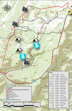
The name Dolly Sods derives from a combination of Dahles, a local 18th century family, and Sods, meaning an open mountain top or meadow. After WWII the area fell into neglect, and was threatened by multiple construction and mining project proposals. Then in the early 1970’s concerned environmentalists, along with The Nature Conservancy, began purchasing the land for preservation and recreational use. Today the Dolly Sods Wilderness Area comprises 17,371 acres.
With over 47 miles of hiking trails following old railroad grades and logging roads there are many hiking circuit options. We have 3 circuit hikes posted here: Dolly Sods North, at 10 miles this hike highlights the high meadows and mountain views. The Forks of Red Creek, in the central section crossing Red Creek and several streams. And this hike, Dolly Sods/Lions Head, that combines the best parts of the first 2, as well as the view from the Lions Head on Breathed Mountain.
This 21.1 mile circuit can be done as either a 2 or 3 day backpack. As a 3 day backpack camp along Big Stonecoal Run the first night, then the Forks of Red Creek the second. This makes for a leisurely 9.4, 5.2, and 6.5 miles each day. Finding camping along the Big Stonecoal Trail TR513 should not be a problem any time, but make sure to arrive in the early afternoon at the Forks of Red Creek on the second day to get a good camp spot. If you decide to do this as a 2 day backpack, still camp along the Big Stonecoal Trail TR513, however this makes for a challenging second day of 11.7 miles back to the parking area.
- Mile 0.0 – From the parking area on FR75 pass the trailhead sign and start down the Bear Rocks Trail TR522. Note that none of the trails in the Dolly Sods area are blazed, however they are well marked with signage. The Bear Rocks Trail is washed out for the first 0.5 miles until it crosses a small stream. Pass over a ridge, and then descend another washed out section to the intersection of the Dobbin Grade Trail TR526 on the left.
- Mile 1.0 – The Bear Rocks Trail becomes narrow passing through a boggy section and over a wooden walkway before arriving at the crossing for Red Creek. Cross Red Creek, then on the left is a nice campsite with slate chairs and fire ring. The trail continues on the left once crossing the creek and climbs steeply for 0.2 miles then makes a sharp turn right into a fern field. Walk over another wooden footpath entering a wooded area where the trail climbs towards the first meadow. Exit the woods and pass over the first open meadow. The Bear Rocks Trail will then descend through a hollow and climb over another rise then end at the intersection of the Raven Ridge Trail TR521.
- Mile 2.3 – Continue straight uphill on the Raven Ridge Trail TR521, then in 0.2 miles reach the intersection of the Beaver View Trail TR523.
- Mile 2.5 – Continue straight on the Raven Ridge Trail TR521 as the trail leaves the meadows, then makes a sharp left hand turn into a wooded area. Exit the wooded area and shortly arrive at the intersection of the Rocky Ridge Trail TR524.
- Mile 3.8 – Turn left on the Rocky Ridge Trail TR524 then in 0.3 miles reach one of the best overlooks of the hike into Canaan Valley. The next 1.4 miles on the Rocky Ridge Trail TR524 passes the area where most of the windswept boulders are located. This section of the trail can be a little tricky to navigate. Just look for small rock cairns.
- Mile 5.5 – Reach the intersection of the Dobbin Grade Trail TR526. Stay right on the Rocky Ridge Trail TR524 climbing over Harman Mountain then arrive at the intersection of the Harman Trail TR525 in 0.9 miles.
- Mile 6.4 – Continue on the Rocky Ridge Trail TR524 for another 0.5 miles to the intersection of the Blackbird Knob Trail TR511.
- Mile 6.9 – Continue downward for 0.2 miles to the 4 way intersection of the Breathed Mountain Trail TR 553, Big Stonecoal Trail TR513, and Forestry Road that leads down to Canaan Valley.
- Mile 7.1 - There are 2 information boards at this intersection with maps of the area. The trail you have been on the Rocky Ridge Trail TR524 ends then becomes the Forestry Road leading to Canaan Valley. Take the narrower Big Stonecoal Trail TR513 directly ahead as it descends into the woods. This section of Dolly Sods is more wooded with heath and sphagnum bogs. Pass several good campsites as you descend gradually along Stonecoal Run.
-
Mile 9.4 – Cross Stonecoal Run.
On the opposite bank is a small campsite in a sandy area. Pass around
the back of the campsite where there is a much nicer camp area 50 yards upstream.
Day 2:
- Mile 9.4 – Continue downstream on the Big Stonecoal Trail TR513 and in 0.2 miles pass the intersection of the Dunkenbarger Trail TR558.
- Mile 9.6 – Continue on the Big Stonecoal Trail TR513 for 0.6 miles crossing Stonecoal Run, then entering a section of dense Rhododendron, pass a waterfall, and arrive at the intersection of the Rocky Point Trail TR554.
- Mile 10.4 – Stay left on the Rocky Point Trail TR554 arriving at a vista to the south. At the point where the trail heads back to the north look closely for an unsigned trail with no blazes, and marked with occasional rock cairns that leads left uphill. This is a rock scramble uphill for the 0.1 miles. Bear right at a flatter area with a nice view of the Lions Head. After exploring the Lions Head return to the Rocky Point Trail TR554 and continue north towards Red Creek.
- Mile 13.2 – The Rocky Point Trail TR554 ends at the intersection with the Red Creek Trail TR514. Continue straight on the Red Creek Trail TR514 for 1.4 miles to the intersection with the Breathed Mountain Trail TR553. Continue on the Red Creek Trail TR514 and shortly arrive at the Forks of Red Creek.
-
Mile 14.6 – There are numerous campsites at ‘The Forks’ but note that this area is an extremely popular camping area, especially with the college set. Explore many small waterfalls and swimming holes.
Day 3 (Optional)
- Mile 14.6 – Cross the Left Fork of Red Creek and stay to your left as the Red Creek Trail TR514 passes through a camping area then re-enters the woods on the left. From this point the Red Creek Trail TR514 becomes steeper until it enters the first of two large meadows. After passing through the second meadow the trail re-enters the woods and ends at the intersection of the Blackbird Knob Trail TR511.
- Mile 15.5 – Turn right on the Blackbird Knob Trail TR511 passing through several boggy sections, then enter a small meadow and arrive at the intersection of the Upper Red Creek Trail TR509.
- Mile 15.9 – Turn left on the Upper Red Creek Trail TR509 passing through several large meadows and gently climb towards the north. The trail will cross another tributary of Red Creek then end at the intersection of the Dobbin Grade Trail TR526.
- Mile 17.2 – Turn right on the Dobbin Grade Trail TR526 for 0.1 miles to the intersection with the Raven Ridge Trail TR521.
- Mile 17.3 – Turn left uphill on the Raven Ridge Trail TR521. WARNING: People look at the map and notice that following the Dobbin Grade Trail back to the Bear Rocks Trail is a shorter route. Don’t do it! The Dobbin Grade Trail is a boggy mess anytime of the year, and offers little scenery. Taking the Raven Ridge Trail TR521 has much nicer views and is completely dry. So, after turning left uphill onto he Raven Ridge Trail TR521 pass through several nice meadows and wooded areas for 1.5 miles back to the intersection with the Bear Rocks Trail TR522 terminus you passed earlier in the hike.
- Mile 18.8 – Turn right on the Bear Rocks Trail TR522 retracing your earlier steps through the meadows, crossing Red Creek, passing the Dobbin Grade Trail terminus, and climbing back to the parking area.
- Mile 19.6 – Arrive back at the Bear Rocks Trailhead and parking area.