-
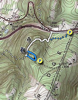
Mile 0.0 - From the large commuter parking area on Rt. 7 start down the west side of the ridge staying on the left side of the Rt. 7 guardrail. DO NOT be tempted to take the unmarked trail that starts up the mountain at the end of the parking area. This unblazed trail marked on our map as blue dotted is generally muddy most of the year and has a large amount of poison ivy on either side.
-
Mile 0.2 - Turn left at the white blazed Appalachian Trail off Rt. 7 heading into the woods uphill. This section has old growth forest, but beware of poison ivy in this area.
-
Mile 0.3 - Pass the intersection of the non-blazed connector trail (muddy) back to the parking area. The Appalachian Trail will make three main switchbacks climbing the ridge then levels off. There are large granite boulders in the trail with veins of quartz.
-
Mile 0.6 - Pass the Bears Den Trail Center connector Trail and arrive at the main Bears Den Overlook. Turn around and head uphill on the Bears Den Connector Trail and shortly arrive at the blue blazed Bears Den Loop Trail. Turn left and follow the loop trail through two clearings and pass around the Bears Den Trail Center. Start downhill on the blue blazed southern portion of the loop trail and soon arrive at the intersection of the Appalachian Trail.
-
Mile 1.1 - Turn right/north on the white blazed Appalachian Trail passing the main overlook and retrace your route back to Rt. 7 turning right back to he parking area.
- Mile 1.7 - Arrive back at the parking area on Rt. 7.
- Distance
- 1.7 mi
- Difficulty
- Easy
- Type
- Out-and-Back
- Est. Time
- 51 min
- Elev. Gain
- 359'
- Rating
- 3.7
- Added
- April 03, 2025
- Updated
- April 06, 2025
Weather Forecast
Don't let Google decide who you trust.


<strong>Trail map and elevation chart not rendering in print mode?</strong> Simply scroll to the trail map section, then try printing again!
90 m
109 m
109 m
Features
- Vista / Lookout Point
- Dogs
-
 Appalachian Trail hike
Points of interest
-
Parking
39.115276, -77.84719 -
Main Trailhead
39.115276, -77.84719
Safety information
For your own safety: plan ahead, let someone know where you'll be, and hike at your own risk.
Hazards
Markers
Blaze Color
WhiteAvailability
Surface type
Trip Reports (Reviews)
Ready to help fellow hikers? Add a trip report to share your experience!


You may also like

25 Best Day Hikes in Virginia
Explore the top hikes in Virginia, from iconic trails in Shenandoah National Park to hidden gems in the Blue Ridge Mountains. Find your next unforgettable outdoor adventure.

25 Best Day Hikes in West Virginia
Discover 25 of the best day hikes in West Virginia, from scenic overlooks to wilderness trails—perfect for every level of hiker.

25 Best Day Hikes in North Carolina
Discover the top 25 best day hikes in North Carolina, from breathtaking waterfalls to mountain peaks. Explore hidden gems, scenic views, and trails suitable for all skill levels, perfect for your next outdoor adventure.

Best of the Alps: Hiking, Adventure & Scenery
Plan your ultimate European Alps adventure! Discover the best hiking trails, epic scenery, and villages in the Swiss Alps, Dolomites, Chamonix, and Lake Como.

