The Annapolis Rock/Black Rock Cliff hike on the Appalachian Trail, is
one of the most popular in Maryland, and for good reason. The views
from both lookouts are spectacular on a clear day. From Annapolis Rock the vista is to the southeast and Greenbrier Lake, and from Black Rock Cliff a 180 degree panorama west.
Visitors should note that this hike should not be confused with the small village of Annapolis Rock, MD which is located ~40 minutes east of this hike.
Annapolis Rock is also a popular camping area, with a campground of 16 sites including 2 group sites. A campground caretaker is also on-site during the warmer months, and helps monitor the area and provide information to hikers. The Annapolis Rock Campground is a non-fee first come-first-serve location.
Annapolis Rock is not only a popular location for hikers, but also a favorite spot for rock climbers. Black Rock Cliff, 1.0 miles further north on the Appalachian Trail is the favorite of the two overlooks with many local hikers for its panoramic views and less traffic.
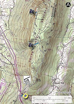
- Mile 0.0 – From the parking area on US40 start down the old paved section of the connector trail. Turn left at the blue blazes for the 75yard walk down to the intersection of the Appalachian Trail (A.T.) and pedestrian bridge over I70.
- Mile 0.1 – Turn right/north on the white blazed AT as it follow I70 and shortly passes beneath US40. This section of the hike is noisy with the traffic on I70, but shortly after passing beneath US40 the A.T. will turn right and start ascending the South Mountain ridge. At the ridge the trail turns back to the left and the noise of the traffic starts fading into the background.
- Mile 0.5 – Pass through a utility clear cut and arrive at the 1st connector trail for the Pine Knob Shelter. Along with the shelter there are 2 large campsites suitable for multiple tents. After passing the 1st Pine Knob Cabin connector trail, pass the second in another 200 yards. From this point the A.T. will become significantly steeper for the next 0.5 miles.
- Mile 1.1 – At the ridge the A.T. will pass through several fern areas and reach the intersection of the Annapolis Rock connector trail.
- Mile 2.5 – Turn left for the 0.2 mile decent to Annapolis Rock Cliff and camping area.
- Mile 2.7 – From the Annapolis Rock Cliff return to the A.T.
- Mile 2.9 – Turn left/north on the A.T. for 1.0 miles to the intersection of the Black Rock Cliff connector trail. The trail sign is not as evident when hiking from the south, but is located just before the A.T. begins a steeper descent.
- Mile 3.9 – Follow the the Black Rock Cliff connector trail for 75 yards to the overlook. To return head south retracing your route back to the US40 connector trail.
- Mile 7.1 – Arrive back at the US40 parking area.