Important: Visitors to Old Rag Mountain, including hikers
on the Saddle, Ridge, and Ridge Access trails, will need to obtain an
Old Rag day-use ticket in advance, in addition to a Park entrance pass. Find out more information on our Old Rag day-use ticket FAQ page. Purchase Old Rag Day-Use Ticket Online
The circuit hike listed here follows the popular clockwise loop, however many hikers prefer to do this loop counterclockwise, thereby tackling the rock scramble at the Ridge Trail on the downhill. Either way, the rock scramble can be challenging, being both steep, and requiring climbing through cracks in the rock. If hiking on the weekend, the best time to arrive is by 7 a.m. beating the crowds.
Note: As of 2020, there are now
three parking areas on SR600/Nethers Rd: Lot 1 - Upper Lot for horse
trailers and RV's, although cars can also park here, the entrance for
this one is about 100 yards beyond the entrance to the Lower Lot. Lot 2 -
Lower Lot, this is now the main parking lot for Old Rag. Lot 3 -
Overflow Lot, only used now when the new Lower Parking Lot is full.
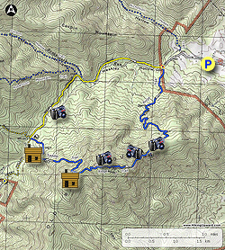
- Mile 0.0 - The hike begins on the Ridge Trail (blue blazed) to the left of Ranger Station at the new Lower Parking Lot. Pass an Information Kiosk and cross a small bridge to begin the climb (gaining 460') to the intersection of the Ridge Access Trail
- Mile 0.8 - At the intersection of the Ridge Access Trail, bear left staying on the Ridge Trail. The trail will gradually increase in grade and make nine switch backs before reaching the first of many view points. From this first vista to the west, the Ridge Trail will become more rocky.
- Mile 2.5 - Arrive at the main easterly vista on the ridge. From here the trail becomes a rock scramble with narrow passages and several spots requiring hand over hand climbing. From the easterly vista on the ridge start up the rock scramble, with the first obstacle a 12ft deep small crack in the rock. At the bottom of the crack continue out to the left. Follow the blue blazes passing around the easterly side of the ridge and through another crack where the trail meets a small cliff. From here, the trail will become increasingly steep going through a small cave, then arriving the minor summit where the trail turns left. Be careful to follow the blue blazes, as there are several false trails that lead to overlooks. After passing around the minor northerly summit, the trail is less steep but still requires rock-hopping for most of the remaining 0.3 miles to the true summit where there are several points with 360° views.
-
Mile 3.6 - Arrive at the Old Rag Summit, elevation 3291'.
-
Mile 4.2 - Descend south along the Ridge Trail for 0.6 miles to the intersection of the Saddle Trail and Byrd's Nest Shelter. Turn right descending on the blue blazed Saddle Trail. In 1.0 miles reach the Old Rag Shelter.
Byrd's Nest Area Scrambling:
For some additional rock scrambling, consider a side trip near the Byrd's Nest Shelter to see the Balance Rock that you can see from Old Rag and the Saddle Trail. About 20 yards from the shelter is a series of rocks worth climbing and to get a bearing (about 300 degrees with our compass pegged on North) to the Balance Rock, about 0.2 miles away. This will involve some bushwhacking, follow a visible path for about 50 yards or so beyond the first set of rocks and it will bear to the right near a campsite and take you below a cliff and the Balance Rock will be visible to the North West, mostly bushwhacking from this point to the Rock. We did not see an easy way to climb Balance Rock but with a little bit of effort we were able to get on the rock just below it for some great views. The coordinates for Balance Rock: N38.5505 W78.3236, the coordinates for the Byrd's Nest Shelter: N38.5501 W78.3211
- Mile 5.2 - Old Rag Shelter, both shelters are available for day use only. From the Old Rag Shelter the trail widens and follows a forestry road for the 0.4 miles to the intersection of the Berry Hollow Fire road (left), Old Rag Fire Road (straight), and Weakley Hollow Fire Road (right).
- Mile 5.6 - Turn right downhill on the yellow blazed Weakley Hollow Fire Road. In 1.2 miles pass the Robertson Mountain Trail, then in another 200 yards the Corbin Hollow Trail. Continue along the Weakley Hollow Fire Road back to the intersection of the Ridge Access Trail
- Mile 8.0 - Arrive at the Ridge Access Trail. This intersection has a small parking area that has been closed for many years. Turn right uphill on the Ridge Access Trail.
- Mile 8.4 - Turn left on the Ridge Trail back towards the Lower Parking Lot.
- Mile 10.1 - Arrive back at the new Lower Parking Lot on Nethers Road.