Please Note: During the last several years the McAfee Knob area has seen a significant increase in hiker traffic. Please follow the Leave-No-Trace hiking etiquette. There are unique rules regarding group size, and camping for this area. Please visit the Roanoke Appalachian Trail club page for full rules and regulations.
There is a new trailhead access at Catawba Sustainability that accesses the A.T. via a fire road and new Catawba Greenway trail. This makes the hike to McAfee Knob roughly 10 miles, however the parking is far less crowded. Detailed description of Catawba Greenway is available here.
This out/back hike is a steady climb of around 1700’ in about 3.9 miles to McAfee Knob from the VA311 parking area so you will get a good workout. On a clear day you will have some of the best views in the Roanoke Valley. Due to its popularity you will not be alone on this hike, but the overhang of McAfee Knob and its views make up for the lack of solitude.
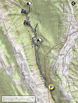
From the right side of the A.T. parking area, cross over VA311 where the Appalachian Trail crosses the road and pick up the white blazed A.T. north. In about 0.3 miles there will be an information kiosk on the left. Continue on the A.T. and pass the Johns Spring Shelter on the right.
In less than 0.1 miles before the Catawba Mountain Shelter on the left, you will notice a spring with a white pipe protruding from some rocks. The water has dried up where there is a plastic pipe near the AT except in early spring or after very heavy rains. The spring goes underground and emerges in pools below the shelter. Follow blue blazes to the the pools. Continue downstream if necessary (note: always treat water from unknown sources). Staying on the A.T. for another 0.1 miles arrive at two good camp sites, the A.T. bears to the left just before the camp sites.
Remain on the A.T., crossing an old fire road and going through a high voltage power line clearing. In 0.3 miles past the power line clearing there will be the first good overlook on the left looking down to the Catawba Valley. Go 0.5 miles further up the trail to the McAfee Knob Spur Trail. Turn left, and in about 30 yards you will reach the top of the Knob with some outstanding views and of course, McAfee Knob protruding out well beyond the rest of the cliffs. There are significant drop offs so be careful.
For your return trip; retrace your steps and head south on the A.T. back to the parking lot for a round trip total of 7.8 miles.
Alternate Route: This section of the A.T. is heavily traveled, and has over 50,000 hikers a year. To avoid the crowds, at the mile 0.3 and information kiosk on the A.T., stay left and take the fire road 2.5 miles to its second intersection with the AT. Turn left at the chain across the fire road and climb that stone steps on the A.T. to begin the last 1.1 mile of your hike to McAfee. On your return trip, turn right when you reach the fire road and walk about 2.5 miles on the fire road. Veer slightly left when you reach the chain across the fire road, climb briefly, and stay right at the top to rejoin the southbound A.T. and return to the parking lot in 0.3 mile.
Camping/Backpacking: If you are
doing McAfee Knob as an overnight backpack, from the McAfee Knob spur
trail turn left onto the A.T heading north for about another 6/10 of a
mile until you reach the Pig Farm Campsite with room for about 4 good
sized tents. In less than 1/10 of a mile after that you will reach the
Campbell Shelter with ample campsites
and a Privy. The water source is a creek about 1/10 of a mile behind
the shelter following a path under the power line and ending up on a
fire road. There are also some good campsites
in a grassy meadow on the way to the water source. A path from the Pig
Farm Campsite also leads to this water source. Staying near the
Campbell Shelter overnight made it possible to hike back up and see a beautiful sunset from McAfee Knob. No camping is allowed on the immediate area surrounding McAfee Knob.
Please review the rules and regulations regarding camping at the Roanoke Appalachian Trail club page.