Please Note: During the last several years the the Dragon’s Tooth area has seen a significant increase in hiker traffic. Please follow the Leave-No-Trace hiking etiquette. There are unique rules regarding group size, and camping. Please visit the Roanoke Appalachian Trail club page for full rules and regulations.
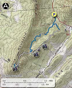
Parking is directly off VA311. From the Dragon’s Tooth parking area head towards the information kiosk located at the rear of the parking area (Note: non-flush toilets are available). The blue blazed Dragon’s Tooth Trail begins at the kiosk. Go about 0.25 miles, crossing two small bridges before arriving at the intersection of the yellow blazed Boy Scout Connector Trail. You will use the Boy Scout Connector Trail on the return trip. Bear to the right on the blue blazed Dragon’s Tooth Trail.
For the next 1.4 miles you will cross the creek/creek bed about 7-8 times on a steady but easy climb to the intersection of the white blazed Appalachian Trail (A.T.) Turn right onto the A.T., heading south towards the Dragon’s Tooth.
Now the fun begins!! The next 0.7 miles is one of the toughest parts of the A.T. that we have hiked. The trail becomes very rocky, climbing multiple series of rock steps, the trail seemingly clinging to the edge of the mountain at times, near the top at two different places you will use a series of u-shaped iron bar steps embedded in the rock due to the steepness of the trail, and a few overlooks to give you a breather prior to reaching the intersection of the blue blazed Dragon’s Tooth Spur Trail, bear left. Imagine doing this part of the trail as an A.T. thru-hiker with 25-35+ lbs on your back!
It is less than 0.3 miles to Dragon’s Tooth on an easy path. Keep your eyes open on the left for a paths leading to overlooks prior to reaching Dragon’s Tooth. Be sure to circle behind the Tooth, as there is a crevice that makes it possible to climb onto the Tooth. It is not the easiest climb, and if you don’t feel comfortable, don’t do it, be safe! There are plenty of good views without climbing the Tooth.
For your return trip; take the blue blazed Dragon’s Tooth Spur Trail back to the intersection of the A.T. taking a right and heading north. Stay on the A.T. reaching the intersection of the Dragon’s Tooth Trail in 0.7 miles. Instead of returning on the blue blazed Dragon’s Tooth Trail stay straight on the more scenic A.T. going north. There will be an overlook in less than 0.25 miles with a campsite (no water) about 0.5 miles beyond that. Take a left in 0.3 miles onto the yellow blazed Boy Scout Connector Trail, and in another 0.3 miles arrive at the blue blazed Dragon’s Tooth Trail passing the campsites mentioned near the beginning of the hike. Take a right on the Dragon’s Tooth Trail arriving at the Dragon’s Tooth Parking Lot in 0.25 miles.