Loading...

🎉 Enjoy a Free 7-Day Supporter Trial and Unlock Exclusive Perks — No Credit Card Required. Learn more.

Three Ridges Hike

Directions
Map
Pictures
Send to App
Distance:
13.2 Miles / 21.2 km
Type:
Loop
Difficulty:
Strenuous
Time to Hike:
6 hours, ~36 minutes
Features:
Appalachian Trail hike
Surface Type:
Dirt
Park:
George Washington National Forest
Town:
White Rock, Virginia
Directions:
37.901459, -78.985262
Added:
February 17, 2025
Updated:
April 05, 2025
Copy Trail Link Hiking this trail? Send a friend or family member a link to this trail guide for your own safety. Hike at your own risk (disclaimer)
Loading...
Loading...
2,181'

Total Change
4,083'

Ascent
4,082'

Descent

Download the Trail Route for Offline Use

Supporters get exclusive access to download trail routes to the MyHikes app for offline use. Stay prepared on your adventure, even without an internet connection! Become a Supporter today to unlock this feature and hike with confidence.

Send to App

Three Ridges Hike

Three Ridges is one of Virginia's most popular backpacking circuits. Situated in Central Virginia, just 30 miles southwest of Charlottesville, the hike has vista after vista along the Appalachian Trail, and many small waterfalls and pools on the Mau-Har Trail on Campbell Creek.

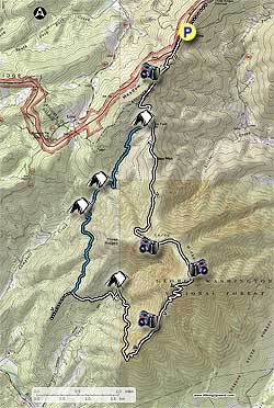
From the parking area at Reeds Gap, head south along the white blazed Appalachian Trail (AT) as it initially hugs the left side of a clearing. At the end of the clearing start climbing Meadow Mountain, and in 0.8 miles arrive at the top of the ridge and campsite/overlook.

Continue along the AT as it now heads downhill, and in 0.8 miles arrives at the Maupin Field Shelter, and intersection with the Mau-Har Trail that will be your return route. The shelter is not visible from this intersection, and is 100 yards downhill. Several small trails intertwine this large camping area.

At the intersection remain left, staying on the AT as it passes a small clearing. The AT will now climb and pass over Bee Mountain in 0.5 miles. Descend Bee Mountain, then climb the northern knoll of Three Ridges and arrive at the best vista of the hike.

Continue up the AT as the trail traverses the ridge before reaching the top of the second knoll in 0.8 miles, and view to the northeast. Look for an unblazed side trail on the left marking the overlook and campsite.

The AT now heads downhill from the hike highpoint, and in 0.1 miles stay right a the trail marker. Descend another 0.2 miles before making a switchback to the left. At the switchback there is another overlook. After making the switchback the AT will descend steeply for 0.8 miles, then pass around the left/north side of Chimney Rock. A faint unblazed trail ascends steeply for 25 yards, then passes around the left side of the summit to the Chimney Rock overlook.

Continue downhill on the AT for another 1.8 miles as the trail descends to the right/south of Three Ridges, then arrives at the main camping area and Harpers Creek Shelter.

Turn left downhill on the AT (opposite side of the creek from the shelter). In 0.1 miles the AT will turn right crossing Harpers Creek before heading uphill, and reaching the intersection of the blue blazed Mau-Har Trail in 0.7 miles at a small pass on the ridge.

Turn right on the blue blazed Mau-Har Trail, descend, switchback up the next ridge, then descend again and reach Campbell Creek and large camping area in 1.5 miles. There is a yellow blazed spur trail that leads downstream to a small pool and waterfall in 200 yards.

Continue upstream on the blue blazed Mau-Har Trail as it becomes steeper, crossing Campbell Creek, and making several switchbacks before arriving at Maupin Field Shelter in another 1.9 miles.

There are several trails at the shelter leading to different campsites. Continue straight past the shelter for 150 yards and reach the intersection of the AT you descended earlier.

Turn left on the AT, then in 20 yards stay right remaining on the white blazed AT. Continue uphill on the AT as it passes back over Meadow Mountain, before descending and arriving back at the parking area at Reeds Gap in 1.6 miles.

Explore 34 trails near White Rock, VA
  1. Parking

    37.901459, -78.985262
  2. Main Trailhead

    37.90138, -78.985176
No community routes found. To add your own hike as a Community Route for this Trail guide, leave a Trip Report with an attached GPX file.

Hazards

Ticks - Lyme Disease More Info (CDC)
Snakes
Poison Ivy/Oak

Seasons

All

Blaze Color

White

Trip Reports

Trail Guide By:
HikingUpward user profile picture
13.2 miles / 21.2 km

Weather Forecast

In White Rock, VA

Explore Hiking Trails

You May Also Like

New York's Best Waterfalls - Whether you're planning a day hike, roadside stop, or a leisurely short walk, this guide provides hikers, travelers, and locals alike with 63 different locations to over 100 scenic waterfalls to help plan your next adventure!
Explore

New York's Best Waterfalls

Whether you're planning a day hike, roadside stop, or a leisurely short walk, this guide provides hikers, travelers, and locals alike with 63 different locations to over 100 scenic waterfalls to help plan your next adventure!

Read
25 Best Day Hikes in North Carolina - Discover the top 25 best day hikes in North Carolina, from breathtaking waterfalls to mountain peaks. Explore hidden gems, scenic views, and trails suitable for all skill levels, perfect for your next outdoor adventure.
Explore

25 Best Day Hikes in North Carolina

Discover the top 25 best day hikes in North Carolina, from breathtaking waterfalls to mountain peaks. Explore hidden gems, scenic views, and trails suitable for all skill levels, perfect for your next outdoor adventure.

Read

Before you boogie...

Find our trail guides useful? Consider becoming a Supporter to unlock perks!

MyHikes is an indie platform that makes exploring public trails easier for everyone. The platform has no investors, no ads, and is owned and operated by one person, Dave Miller. Dave has personally mapped and written over 1,800 trail guides on MyHikes for the public to explore. MyHikes has helped millions outdoor enthusiasts plan their next adventure.

But it takes a lot of time 🕦, money 💰, work, and espresso shots ☕ to run MyHikes, including hiking , mapping , writing , and publishing new trails with high-quality (accurate) information... along with software engineering (coding) the platform like building new features, website and mobile app development (iOS and Android), site maintainance . and much much more.

Supporters unlock website and mobile app perks with an annual one-time payment of $25 (you renew) 😎👍. Or you can simply make a Donation of your choice. Otherwise, you can support us by telling your friends about MyHikes - both quick and free 🎉

Admin user profile picture

Dave Miller
MyHikes Founder