Loading...

WINTER SALE! 50% OFF Supporter Accounts — now through January 31st. Learn More.

Kennedy Peak Hike

Kennedy Peak has some of the best vistas in the region. The out and back hike ends with a spectacular 360° view from the fire tower viewing platform at the summit of Kennedy Peak. The hike itself is reasonably easy. It starts with a gentle incline along the ridge, then climbs more steeply around the western flank of the peak. If you're looking for more of a challenge, add the Stephens Trail to create a 9.2 mile 1,590 ft gain loop hike. Also before starting out take a moment to check out the paragliding launch area with easterly views of the Shenandoah River and Luray Valley.

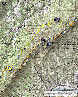
Important Parking Note: As of 2020 parking is no longer permitted on the VA 675 ridge. If you park there you may be towed or ticketed.

  • Mile 0.0 - Near the entrance to the Stephens trailhead parking area the orange blazed Massanutten Trail will start uphill towards the ridge. The trail will make several switchbacks as it climbs towards the ridge.
  • Mile 0.9 - Arrive at VA675 and ridgeline. Turn left-north staying on the orange blazed Massanutten Trail as it follows an old forestry road. The trail is wide and climbs gradually along the ridge for 1.3 miles.
  • Mile 2.2 - Descend through a saddle where the trail then climbs around the eastern side of Kennedy Peak before making a hairpin turn back towards the western side of the mountain.
  • Mile 3.1 - Arrive at a split in the trail. Follow the trail to the left for 25 yards to a campsite and semi-obstructed view of Fort Valley. Return to the Massanutten Trail and continue uphill for another 0.2 miles to the ridge and intersection with the white blazed Kennedy Peak Trail.
  • Mile 3.3 - Turn right and follow the Kennedy Peak trail as it climbs for the remaining 0.2 miles to the Kennedy Peak fire tower.
  • Mile 3.5 - From the fire tower lookout platform there are expansive 360° views of the Luray Valley and South Fork of the Shenandoah River to the east, and the Massanutten Range including Duncan Knob and Kerns Mountain to the southwest.
6.8 Mile Out/Back Hike: From the fire tower retrace your route back to VA675, then down the orange blazed trail back to the Stephens trailhead to complete the 7.0 mile out and back hike.

9.2 Mile Loop Hike: From the fire tower continue north on the orange blazed Massanutten Trail then descend and follow the yellow blazed Stephens Trail south to the lower parking area.
Explore 103 trails near Luray, VA

Know Before You Go

  • Kennedy Peak offers a relatively easy 6.8-mile out-and-back hike with rewarding 360° views from a fire tower at the summit.
  • Parking is no longer allowed on VA 675; utilize the Stephens Trailhead parking area.
  • The hike features varied terrain, including a gentle ridge walk and a steeper climb, with the option to extend the hike into a more challenging 9.2-mile loop via the Stephens Trail.
Interactive topographic map for Kennedy Peak Hike located in Luray, VA. Click the "View Map" button to load GPS coordinates and trail markers.
Get directions
Distance
6.8 mi
Difficulty
Moderate
Type
Out-and-Back
Est. Time
3.4 hrs
Elev. Gain
1,353'
Rating
3.8
Added
January 27, 2025
Updated
April 04, 2025

Weather Forecast

Today
High 39°F
Mostly Cloudy
Tonight
Low 5°F
Partly Cloudy
Saturday
High 17°F
Partly Sunny then Slight Chance Light Snow
Saturday Night
Low 10°F
Heavy Snow
Sunday
High 21°F
Heavy Snow
Sunday Night
Low 12°F
Light Snow
Monday
High 24°F
Chance Light Snow then Mostly Sunny
Monday Night
Low -2°F
Mostly Clear
Tuesday
High 27°F
Sunny
Tuesday Night
Low 5°F
Mostly Clear
Wednesday
High 27°F
Partly Sunny
Wednesday Night
Low 4°F
Mostly Cloudy then Slight Chance Light Snow
Thursday
High 21°F
Slight Chance Light Snow then Mostly Sunny
Thursday Night
Low 2°F
Partly Cloudy
Loading...
Total Change
1,157'
Ascent
1,353'
Descent
1,353'
Loading...

Download the GPX Data for Offline Use

Supporters get exclusive access to download trail routes to the MyHikes app for offline use. Stay prepared on your adventure, even without an internet connection! Become a Supporter today to unlock this feature and hike with confidence.

Download Kennedy Peak Hike GPX Data to the MyHikes Mobile App

Features

Vista / Lookout Point
Dogs
Mountain Summit
Camping

Points of interest

  1. Parking

    38.72795, -78.51536
  2. Main Trailhead

    38.72795, -78.51536

Safety information

For your own safety: plan ahead, let someone know where you'll be, and hike at your own risk.

Hazards

Snakes (Rattlesnakes, Copperheads, others)

Markers

Blaze Color

Orange

Availability

All seasons

Surface type

Dirt

Trip Reports (Reviews)

Rated 3.8 out of 5 based on 50 ratings.

Ready to help fellow hikers? Add a trip report to share your experience and provide valuable insights for other hikers!

By: Heathen VSOP
6.8 miles / 10.9 km
October 01, 2019
Nice short hike for a stretch and with a great view from the tower on Kennedy Peak. There is no water source(s) on the trail out or at Kennedy, so take along a couple of liters. Trail was in good condition but with some erosion at the trailhead. No litter in the back country or parking area, but some horse manure in spots and some almost to the tower. Trail blazes were in good condition and about what i'd expect from any trail in VA. Intersections had signs that were in good condition and even showed the obvious intersection between the Massanutten Trail (orange blaze) and Kennedy Peak trail (white blaze) The hairpin turn in the trail after the saddle is pretty obvious with a line of boulders and a tree trunk on top. Still, some people didn't seem to get the hint from the directions on this site or that this was obvious trail maintenance. Taking the time to understand trail markings makes for a better experience and less outrage that it's not Central Park. I was surprised at how many other hikers I encountered mid-week. It wasn't a crowd, but more that I'd expected for a weekday. Leaves are starting to change but are muted because of the drought conditions. Great views from the tower and worth the time.
Legacy Review
By: Kevin
6.8 miles / 10.9 km
June 23, 2019
Relatively easy hike early half (logging road), 2nd half up is full of rocky trail terrain. Not difficult if you have good ankles. I rate the difficulty between a 2 and 3 mostly due to rocky travel. Fantastic view of the Shenandoah valley and Luray VA looking east. Nice day hike
Legacy Review
By: Tale of two hikes
6.8 miles / 10.9 km
May 01, 2019
Kennedy Peak is a tale of two hikes. The section of Massanutten Trail up to the old fire tower, and the view from the fire tower are great - a definite 5. The continuation of the loop on the Stephens Trail, on the other hand, is rate "poor" in my opinion. It's a long boring slog through muddy lowland trail, full of horse manure, with nothing to show for it. Do an out-and-back and forget the loop (hence the rating)
Legacy Review
No community routes found. To add your own hike as a Community Route for this Trail guide, leave a Trip Report with an attached GPX file.

Popular categories

Scenic mountain view representing vista trails
Vista trails
Scenic gorge of cascades representing waterfall trails
Waterfall hikes
Rugged mountain terrain representing summit trails
Summit trails
Scenic mountain view representing dog-friendly trails
Dog-friendly
Scenic campsite with a view representing camping trails
Camping trails
Appalachian Trail logo representing A.T. hikes
A.T. hikes

You May Also Like

25 Best Day Hikes in North Carolina - Discover the top 25 best day hikes in North Carolina, from breathtaking waterfalls to mountain peaks. Explore hidden gems, scenic views, and trails suitable for all skill levels, perfect for your next outdoor adventure.
Explore

25 Best Day Hikes in North Carolina

Discover the top 25 best day hikes in North Carolina, from breathtaking waterfalls to mountain peaks. Explore hidden gems, scenic views, and trails suitable for all skill levels, perfect for your next outdoor adventure.

Read
🍪 We use cookies to learn about site usage and to serve map tiles. You may block cookies manually in the browser. By continuing you agree. Learn more