Loading...

🔥 End of Summer sale! 50% off on Supporter Accounts — now through September 1st. Learn More.

Humpback Rocks Hike

Directions
Map
Pictures
Send to App
Distance:
4.1 Miles / 6.6 km
Type:
Loop
Difficulty:
Hard
Time to Hike:
2 hours, ~5 minutes
Features:
Appalachian Trail hike
Surface Type:
Dirt
Park:
George Washington National Forest
Town:
Afton, Virginia
Directions:
37.968459, -78.89656
Added:
January 27, 2025
Updated:
April 04, 2025
Guide by:
Copy Trail Link Hiking this trail? Send a friend or family member a link to this trail guide for your own safety. Hike at your own risk (disclaimer)
Loading...
Loading...
1,135'

Total Change
1,170'

Ascent
1,162'

Descent

Download the Trail Route for Offline Use

Supporters get exclusive access to download trail routes to the MyHikes app for offline use. Stay prepared on your adventure, even without an internet connection! Become a Supporter today to unlock this feature and hike with confidence.

Send to App

Humpback Rocks Hike

Humpback Rocks is a very popular hike due to its proximity to the Blue Ridge Parkway and I-64 near Afton Mountain. Most people do it as a 1.0 mile up and back. We decided to add a few miles for the return trip by following the Appalachian Trail North and a couple of un-named blue-blazed trails.

The 1.0 miles to the Rocks is very tough, gaining about 800'. The views at the Rocks are great looking west onto the Shenandoah Valley and north to Shenandoah National Park.

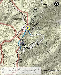
We parked at the Humpback Rocks parking area (MP6 on the Blue Ridge Parkway). The blue-blazed trail begins to the right of the kiosk . The trail wastes no time ascending with park benches scattered every so often if you need to take a break. Don't be fooled by the 1.0 mile to the top, if you are not used to hiking you will find muscles sore that you forgot you had!!

There will be an intersection on your left in 0.5 miles, ignore it and stay straight on the blue blazed trail. For the next 0.4 miles the trail is very rocky but there are both wooden steps and rock steps for some of the more difficult parts. If it has rained be prepared that the trail can be a little muddy and in some places becomes a temporary stream. At the next intersection bear left on the spur trail to the Rocks and some incredible views. There are multiple places to take photos, just be careful especially if wet. We were a little disappointed in the amount of graffiti at the Rocks but try to ignore it and concentrate on the views.

Return to the intersection with the 'Rocks' sign, ignore references to the A.T. as those are old signs when it ran close to the Rocks before it was re-routed years ago. At the 'Rocks' intersection, go straight on the blue blazed trail towards Humpback Picnic Area and reach the A.T. in less than 0.10 miles.

Turn left onto the white-blazed A.T. North (*for additional views see A.T. South Out and Back directions below). This begins a 2.7 mile gradual descent for most of the trail back to the Parking area. We saw lots of wildlife: eastern newt, deer and tons of chipmunks - they are too fast to get a decent photo. The mountain laurel and rhododendrons were blooming all over this section of the trail. Returning this way made for a very pleasant stroll and we ran in to only a couple of hikers. The next intersection is in 2.7 miles. Bear to the left, onto a blue-blazed trail to return to the Humpback Rocks Parking area.

*A.T. South Out and Back for Additional Views

If you prefer seeing more great views without the crowds take the A.T. South instead of North at the Intersection mentioned in the previous paragraph. If you take in all 3 additional views in this out and back you will add about 4 miles to your trip. In 0.4 miles from the intersection you will come to an unmarked spur trail to take you out to the first view. These rocks are very similar to Humpback Rocks but not as massive. You will see these rocks on your left as you are on the trail and at the top of the hill you will come to the spur trail. Continue south on the A.T. for 0.7 miles to reach the second view on your left looking out to Rockfish Valley on the east and Shenandoah Valley on the west. The last view will be 0.9 miles beyond the second view. About 30 yards before the last view you will pass a great campsite with room for about 6 tents. We actually did this as a short overnight backpack and spent the night at this campsite taking in one of the most beautiful sunsets we have ever seen in Virginia. You will have an almost 180 degree view of Rockfish Valley, Wintergreen Resort, and finally the Shenandoah Valley. This is your turn around point. Note: If you do camp here, bring plenty of water as there are no water sources on this section of the A.T.

Explore 36 trails near Afton, VA
  1. Parking

    37.968459, -78.89656
  2. Main Trailhead

    37.968628, -78.896599
No community routes found. To add your own hike as a Community Route for this Trail guide, leave a Trip Report with an attached GPX file.

Hazards

Ticks - Lyme Disease More Info (CDC)
Snakes

Seasons

All

Blaze Color

White

Trip Reports (Reviews)

Rated 3.91 out of 5 based on 54 ratings.
By: Davey James
4.1 miles / 6.6 km
August 25, 2019
For August, today was a beautiful day. Therefore, there were a great deal of people on the trail. I'm not sure if it's always this crowded but today it was highly populated. The trail is well maintained. It is challenging for the first couple of miles - as it goes pretty much straight up! I brought my dog with me (there were several dogs out today.) I didn't get to enjoy the views from Humpback rock because there were just too many people cluttered there and it's not ideal for dogs. So, I decided to hike towards the AT for some additional exercise and serenity. This was my favorite part of the hike because there is less traffic. Overall, a nice hike - but, I won't do this one again with my dog.
Legacy Review
By: AAP
4.1 miles / 6.6 km
August 05, 2019
Started my solo hike up Humpback Mountain around the Parking area after checking in with the Rangers at the Visitors Center at 9:30am on a Monday, and I was one of the first cars in the lot. Ranger report: Black bears and some rattlers have been seen on the local trails, but all I saw were a garter snake, a gray squirrel, and a chipmunk... and a ton of butterflies and centipedes. The first mile to the Rocks was very nice, though as advertised, very steep. Recent rain led to a few muddy spots, slick spots, and a hint of standing water. Great scents kicked up by the rain and humidity, though... really felt like I was outdoors. I'm slow, so I was passed by about 20 folks on my way up, and only a few passed me headed back down before I got to the top, so the Rocks were crowded. I didn't linger at the Rocks, but the photo op is not to be missed. The left turn off to the Rocks was clearly marked. I then continued up (following markers to the Appalachian Trail), and followed signs toward the Summit. Note that the tree blazes change from blue (Rocks trail) to white (Appalachian Trail). Continued up for about another mile. Still definitely upward, but I'd guess about half as steep as the trail to the Rocks. There was no clear indication that I saw that I'd come to the summit, so I just kept on for a bit. Some landmarks were (1) when I crossed through a stone wall, that was where I believe the first "summit" is. Then you go down into a gulley and back up to what I thought of as a second "summit." Finally, there was a second gulley and another upward motion which led to a beautiful viewpoint. I couldn't find any higher points that that, so I'm going to call that the Summit. All in all, I measured that to be about 1.8 - 2.0 miles past the Rocks. Trip back was easier, but I'm glad I had trekking poles to deal with the slippery rocks and muddy trail.
Legacy Review
By: Bob W
4.1 miles / 6.6 km
October 07, 2018
Excellent hike- my wife and I (both 48 years old) thoroughly enjoyed this outing. Took short breaks as needed- which was more often than I thought, but we never felt over matched by the incline. But it was steep and slippery in many spots. Starting out early was the key to making this so good, because it meant that we were able to enjoy the summit for about 20 minutes with very little crowd (only one or two other couples) - so plenty of space to hang out and enjoy the breeze in a very peaceful environment. Judging by the number of people coming up the trail as we were going down, and the crowded parking lot upon our return I don't imagine those people got the same serenity we did at the top. Saw more people than I thought I would carrying small children on their way up- they did not look to be enjoying it.
Legacy Review

Weather Forecast

In Afton, VA

Explore Hiking Trails

You May Also Like

New York's Best Waterfalls - Whether you're planning a day hike, roadside stop, or a leisurely short walk, this guide provides hikers, travelers, and locals alike with 63 different locations to over 100 scenic waterfalls to help plan your next adventure!
Explore

New York's Best Waterfalls

Whether you're planning a day hike, roadside stop, or a leisurely short walk, this guide provides hikers, travelers, and locals alike with 63 different locations to over 100 scenic waterfalls to help plan your next adventure!

Read
25 Best Day Hikes in North Carolina - Discover the top 25 best day hikes in North Carolina, from breathtaking waterfalls to mountain peaks. Explore hidden gems, scenic views, and trails suitable for all skill levels, perfect for your next outdoor adventure.
Explore

25 Best Day Hikes in North Carolina

Discover the top 25 best day hikes in North Carolina, from breathtaking waterfalls to mountain peaks. Explore hidden gems, scenic views, and trails suitable for all skill levels, perfect for your next outdoor adventure.

Read

Before you boogie...

Find our trail guides useful? Consider becoming a Supporter to unlock perks!

MyHikes is an indie platform that makes exploring public trails easier for everyone. The platform has no investors, no ads, and is owned and operated by one person, Dave Miller. Dave has personally mapped and written over 1,800 trail guides on MyHikes for the public to explore. MyHikes has helped millions outdoor enthusiasts plan their next adventure.

But it takes a lot of time 🕦, money 💰, work, and espresso shots ☕ to run MyHikes, including hiking , mapping , writing , and publishing new trails with high-quality (accurate) information... along with software engineering (coding) the platform like building new features, website and mobile app development (iOS and Android), site maintainance . and much much more.

Supporters unlock website and mobile app perks with an annual one-time payment of $25 (you renew) 😎👍. Or you can simply make a Donation of your choice. Otherwise, you can support us by telling your friends about MyHikes - both quick and free 🎉

Admin user profile picture

Dave Miller
MyHikes Founder