The Webber Homestead & Vistas Hike at Tiadaghton State Forest near Slate Run, Pennsylvania is a difficult 5.3-mile out-and-back hike that features 8 stunning views of the PA Grand Canyon, the Webber homestead site, and the 10-foot tall waterfall, Naval Run Falls.
Trails
This hike follows several named trails in the following order: Naval Run Trail (yellow blazes), Black Forest Trail (orange blazes), Gas Line Trail (red blazes), Black Forest Trail (orange blazes), Lance Raisch Trail (yellow blazes).
Hike Description
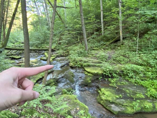
This hike begins at the end of Naval Run Road and heads to the Naval Run Trail located behind the permit-only campsite. Note that this hike is an out-and-back with two loops on each end, hence, the Lance Raisch Trail (yellow blazes) can be found to your right-hand side on the hike in, but you'll have the option to hike that on the way out. Hikers will follow the Naval Run Trail as it crosses Naval Run Creek, then will keep-right to head uphill toward the Black Forest Trail and Naval Run Falls.
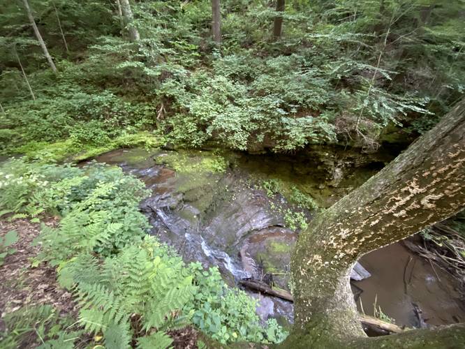
Naval Run Falls - Mile 0.35
At mile 0.35, hikers will reach the Black Forest Trail (BFT) and will take a right-hand turn. Immediately after hopping on the BFT, hikers will find the 10-foot tall waterfall, named Naval Run Falls, located below your feet. While the view of Naval Run Falls is from the top of the waterfall, this is a nice spot to take a quick break and enjoy the cascading water. From here, hikers will head across the creek to continue up the Black Forest Trail via switchbacks.
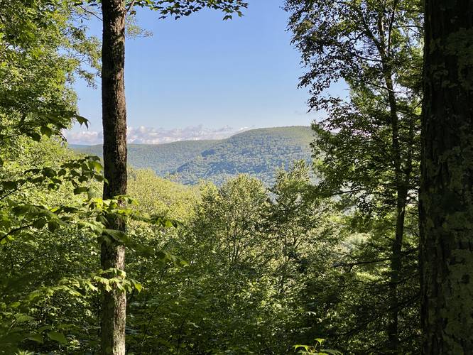
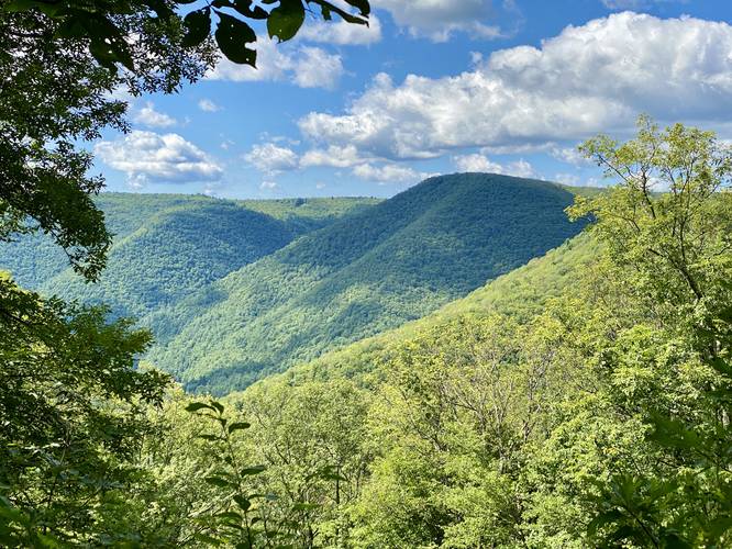
Climbing Up & PA Half Dome Vista - Mile 0.35 to 1.5
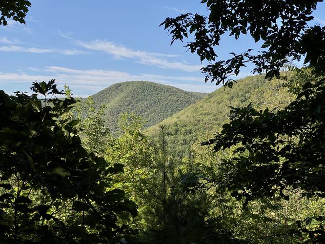
From miles 0.35 to 1.5, hikers will follow switchbacks up the mountain as you slowly ascend. Before reaching a bench in the mountain's slopes, hikers will find a nice south-facing vista of Half Dome Mountain (aka PA Half Dome).
PA Half Dome Vista - Mile 1.3
Around mile 1.3, hikers will reach a nicer view of Half Dome Mountain (aka PA Half Dome), where it includes signage about Half Dome Mountain as its the steepest rise from Pine Creek. Just after this 2nd view of PA Half Dome is where the trail begins to level out along the bench in the mountain, making for easier and more pleasant hiking.
Hidden Campsite - Mile 1.4
Around mile 1.4, located off-trail and down a mossy path is a small flat camping area with a very old campfire pit that can be used by backpackers.
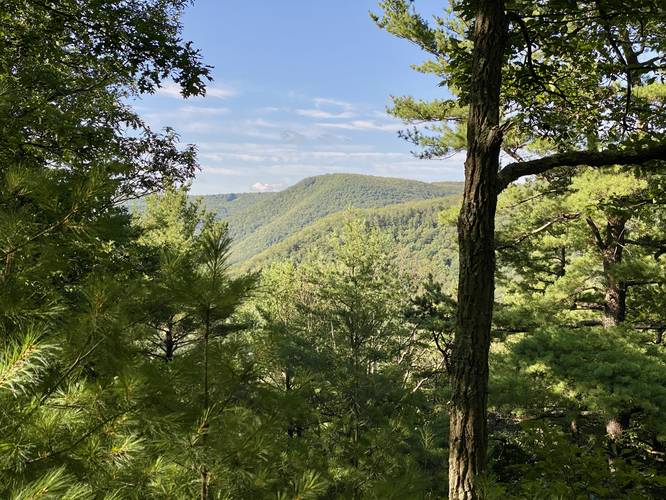
Algerine Wild Area Vista - Mile 1.43
Around mile 1.43, located just off-trail, is a north-facing view of the mountains within the Algerine Wild Area. A keen-eyed hiker may even spot the old quarry on the side of the mountain.
PA Half Dome Vista (3rd) - Mile 1.55
Around mile 1.55, hikers will reach a 3rd south-facing view of Half Dome Mountain (aka PA Half Dome).
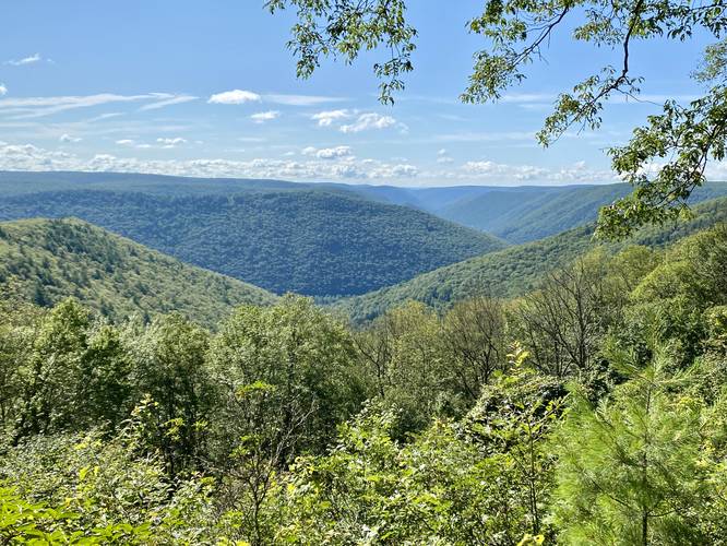
Canyon View & Campsite - Mile 1.65
Around mile 1.65, hikers will reach a north-facing view into the PA Grand Canyon with Pine Creek Valley sitting directly below your feet. A keen-eyed hiker may also be able to spot Bull Run Point which sticks out into the canyon, the Dragon's Back mountain ridge's slopes on the right-hand side, or the mountains that make-up the Hilborn Loop. There's also a small campsite and fire pit that backpackers can use.
Hemlock Mountain View - Mile 1.85
Around mile 1.85, hikers will reach a southwest-facing view of the neighboring mountains, including the backside of Hemlock Mountain, albeit this is probably the least-interesting view on the entire hike but is still nonetheless.
Left-Hand Turn to BFT - Mile 2
Around mile 2, hikers will reach a 4-way trail junction. You'll hike back to this point but first take a left-hand turn to continue along the Black Forest Trail.
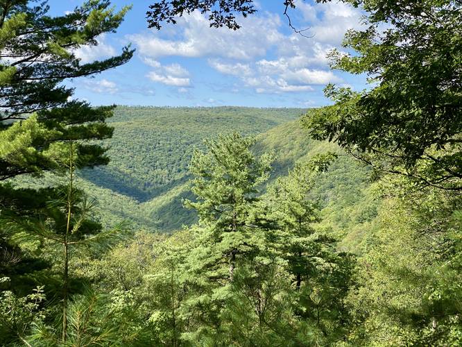
Dragon's Back Vista - Mile 2.5
At mile 2.5, hikers will reach another awesome view of Pennsylvania's Grand Canyon - the Dragon's Back Vista. From here, hikers get a view, directly across the canyon, of the Dragon's Back, Quarry Mountain, the slopes of Hemlock Mountain, and the Ravens Horn along the Bob Webber Trail. This is one of the more expansive views along the hike and includes a bench so hikers can sit to take a break while enjoying the view. After taking in the views, hikers will continue on the BFT toward the Gas Line Trail.
Right-Hand Turn (Gas Line Trail) & Trail Registry - Mile 2.85
Around mile 2.85, hikers will reach the Gas Line Trail and will take a right-hand turn here to head toward the Webber Homestead site. There's also a BFT trail registry box here.
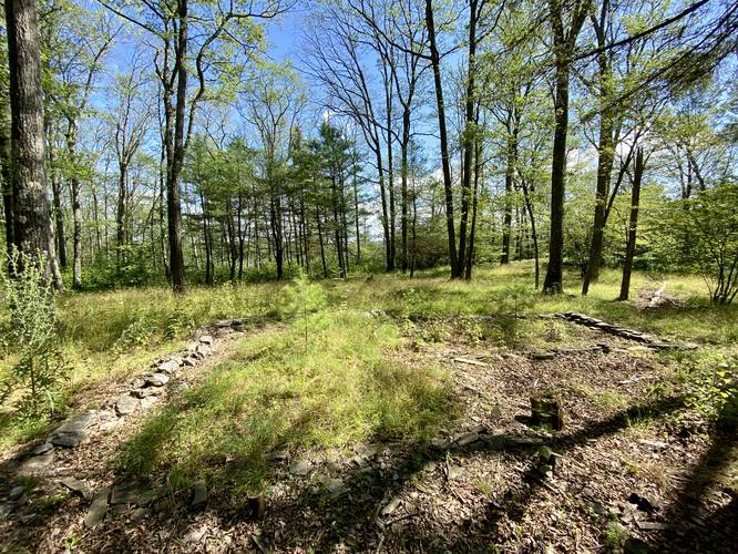
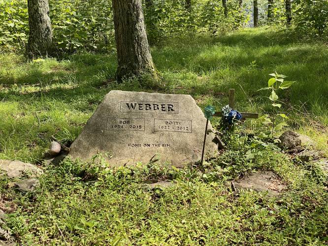
Webber Homestead Site - Mile 3.1
Around mile 3.1, hikers will reach a stone path in the forest that leads north to several wooden posts in the ground. This short stone path leads to where the Webber's (Dotty and Bob) had their life-long homestead atop the Allegheny Front. The Webbers lived in their cabin atop this mountain for decades and Bob worked for 24 years with the Pennsylvnia Bureau of Forestry. Bob built the Golden Eagle Trail, Black Forest Trail, Pitch Pine Loop Ski Trail, and a trail that was eventually named after him - the Bob Webber Trail. After both Bob and Dotty passed away, their homestead was moved to the PA Lumber Museum where visitors can explore the original Webber Cabin. Located near the old foundation of the cabin is the graves of both Bob and Dotty, sitting quietly between their home and the stunning view from their backyard. If you'd like to learn more about Bob and Dotty Webber, you can read a couple of different articles like this Farewell to Bob Webber article or the Lumber Museum's article on the Webber Cabin.
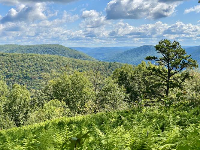
Webber Canyon Vista - Mile 3.15
Just behind the Webber's gave site is their backyard view of the PA Grand Canyon. This stunning vista includes views of Pine Creek, the Algerine Wild Area, Gillespie Point and the mountains that make up the Hillborn Loop.
After visiting the Webber Homestead site, hikers will head southeast along the Gas Line Trail to reach the 4-way junction they previously hiked to. Head straight along the BFT to hike down the mountain.
Lance Raisch Trail to Parking - Mile 5.05 to 5.3
Note that this GPS track brings hikers own a root-filled, skinny, and sketchy section of the Lance Raisch Trail (yellow blazes). This short but sketchy path bypasses the two Naval Run creek crossings and reduces the mileage of the hike without following the exact paths on the hike in. If you plan to take the Lance Raisch back to parking, take your time and watch your step.
Parking
Hikers will find a couple of small parking turnouts by the trailhead at the end of the road.
Pets
Dogs are allowed if leashed and should be cleaned up after.
Camping and Backpacking
Backpacking and camping are allowed on this trail, but backpackers must follow the state forest rules and regulations.
Trails
This hike follows several named trails in the following order: Naval Run Trail (yellow blazes), Black Forest Trail (orange blazes), Gas Line Trail (red blazes), Black Forest Trail (orange blazes), Lance Raisch Trail (yellow blazes).
Hike Description
This hike begins at the end of Naval Run Road and heads to the Naval Run Trail located behind the permit-only campsite. Note that this hike is an out-and-back with two loops on each end, hence, the Lance Raisch Trail (yellow blazes) can be found to your right-hand side on the hike in, but you'll have the option to hike that on the way out. Hikers will follow the Naval Run Trail as it crosses Naval Run Creek, then will keep-right to head uphill toward the Black Forest Trail and Naval Run Falls.
Naval Run Falls - Mile 0.35
At mile 0.35, hikers will reach the Black Forest Trail (BFT) and will take a right-hand turn. Immediately after hopping on the BFT, hikers will find the 10-foot tall waterfall, named Naval Run Falls, located below your feet. While the view of Naval Run Falls is from the top of the waterfall, this is a nice spot to take a quick break and enjoy the cascading water. From here, hikers will head across the creek to continue up the Black Forest Trail via switchbacks.
Climbing Up & PA Half Dome Vista - Mile 0.35 to 1.5
From miles 0.35 to 1.5, hikers will follow switchbacks up the mountain as you slowly ascend. Before reaching a bench in the mountain's slopes, hikers will find a nice south-facing vista of Half Dome Mountain (aka PA Half Dome).
PA Half Dome Vista - Mile 1.3
Around mile 1.3, hikers will reach a nicer view of Half Dome Mountain (aka PA Half Dome), where it includes signage about Half Dome Mountain as its the steepest rise from Pine Creek. Just after this 2nd view of PA Half Dome is where the trail begins to level out along the bench in the mountain, making for easier and more pleasant hiking.
Hidden Campsite - Mile 1.4
Around mile 1.4, located off-trail and down a mossy path is a small flat camping area with a very old campfire pit that can be used by backpackers.
Algerine Wild Area Vista - Mile 1.43
Around mile 1.43, located just off-trail, is a north-facing view of the mountains within the Algerine Wild Area. A keen-eyed hiker may even spot the old quarry on the side of the mountain.
PA Half Dome Vista (3rd) - Mile 1.55
Around mile 1.55, hikers will reach a 3rd south-facing view of Half Dome Mountain (aka PA Half Dome).
Canyon View & Campsite - Mile 1.65
Around mile 1.65, hikers will reach a north-facing view into the PA Grand Canyon with Pine Creek Valley sitting directly below your feet. A keen-eyed hiker may also be able to spot Bull Run Point which sticks out into the canyon, the Dragon's Back mountain ridge's slopes on the right-hand side, or the mountains that make-up the Hilborn Loop. There's also a small campsite and fire pit that backpackers can use.
Hemlock Mountain View - Mile 1.85
Around mile 1.85, hikers will reach a southwest-facing view of the neighboring mountains, including the backside of Hemlock Mountain, albeit this is probably the least-interesting view on the entire hike but is still nonetheless.
Left-Hand Turn to BFT - Mile 2
Around mile 2, hikers will reach a 4-way trail junction. You'll hike back to this point but first take a left-hand turn to continue along the Black Forest Trail.
Dragon's Back Vista - Mile 2.5
At mile 2.5, hikers will reach another awesome view of Pennsylvania's Grand Canyon - the Dragon's Back Vista. From here, hikers get a view, directly across the canyon, of the Dragon's Back, Quarry Mountain, the slopes of Hemlock Mountain, and the Ravens Horn along the Bob Webber Trail. This is one of the more expansive views along the hike and includes a bench so hikers can sit to take a break while enjoying the view. After taking in the views, hikers will continue on the BFT toward the Gas Line Trail.
Right-Hand Turn (Gas Line Trail) & Trail Registry - Mile 2.85
Around mile 2.85, hikers will reach the Gas Line Trail and will take a right-hand turn here to head toward the Webber Homestead site. There's also a BFT trail registry box here.
Webber Homestead Site - Mile 3.1
Around mile 3.1, hikers will reach a stone path in the forest that leads north to several wooden posts in the ground. This short stone path leads to where the Webber's (Dotty and Bob) had their life-long homestead atop the Allegheny Front. The Webbers lived in their cabin atop this mountain for decades and Bob worked for 24 years with the Pennsylvnia Bureau of Forestry. Bob built the Golden Eagle Trail, Black Forest Trail, Pitch Pine Loop Ski Trail, and a trail that was eventually named after him - the Bob Webber Trail. After both Bob and Dotty passed away, their homestead was moved to the PA Lumber Museum where visitors can explore the original Webber Cabin. Located near the old foundation of the cabin is the graves of both Bob and Dotty, sitting quietly between their home and the stunning view from their backyard. If you'd like to learn more about Bob and Dotty Webber, you can read a couple of different articles like this Farewell to Bob Webber article or the Lumber Museum's article on the Webber Cabin.
Webber Canyon Vista - Mile 3.15
Just behind the Webber's gave site is their backyard view of the PA Grand Canyon. This stunning vista includes views of Pine Creek, the Algerine Wild Area, Gillespie Point and the mountains that make up the Hillborn Loop.
After visiting the Webber Homestead site, hikers will head southeast along the Gas Line Trail to reach the 4-way junction they previously hiked to. Head straight along the BFT to hike down the mountain.
Lance Raisch Trail to Parking - Mile 5.05 to 5.3
Note that this GPS track brings hikers own a root-filled, skinny, and sketchy section of the Lance Raisch Trail (yellow blazes). This short but sketchy path bypasses the two Naval Run creek crossings and reduces the mileage of the hike without following the exact paths on the hike in. If you plan to take the Lance Raisch back to parking, take your time and watch your step.
Parking
Hikers will find a couple of small parking turnouts by the trailhead at the end of the road.
Pets
Dogs are allowed if leashed and should be cleaned up after.
Camping and Backpacking
Backpacking and camping are allowed on this trail, but backpackers must follow the state forest rules and regulations.