The Hilborn Loop at State Game Lands 68 near Slate Run, Pennsylvania is a difficult 7.3-mile hike that features five vistas, several waterfalls, and encompasses a natural mountain "bowl" in the PA Grand Canyon.
Trails
This hike follows several named trails in the following order: Pine Creek Trail, Hilborn Trail, Unnamed Service Road, (optional) out-and-back hike down the Golden Eagle Trail, Unnamed Service Road, Hilborn Run Trail, and the Pine Creek Trail back to parking.
Hike Description
This hike begins along PA-414 just north of Slate Run in the village of Hilborn. Hikers will find a small parking turnout at the coordinates provided that sits adjacent to the Pine Creek Trail. The parking lot is located just south of the one-lane metal "singing" bridge that crosses Pine Creek.
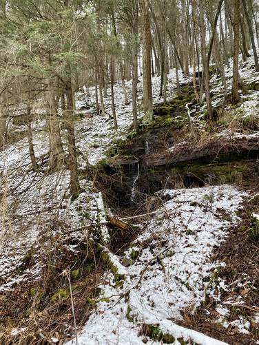
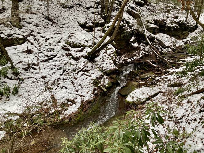
Pine Creek Trail - Mile 0 to Mile 0.85
From the parking lot hikers will follow the flat Pine Creek Trail (rail trail) north as it passes several creeks and runs that spill down the mountainside. Some of these waterfalls are more seasonal - either they run after a heavy rain or snow melt; however, they're impossible to miss - most of the "free fall" cascades in these waterfalls is not much taller than 7-feet, but the water cascades down the mountainsides in multiple cascades and tiers.
Hilborn Trail - Mile 0.85
Around mile 0.85, hikers will reach Hilborn Run with a wooden bridge that spans the creek. Here, hikers will cross the bridge and then take a right-hand turn onto a very-steep and skinny path that begins your ascent up the mountain - the Hilborn Trail. This trail may be hard to see, but simply look at the steep hillside where the bridge's railing ends. The Hilborn Trail is very difficult along this mountain ridge and should be considered Difficult (Hard) to Strenuous, depending on your hiking skill level. This trail ascends the mountain ridge and includes several rocky outcroppings along the way.
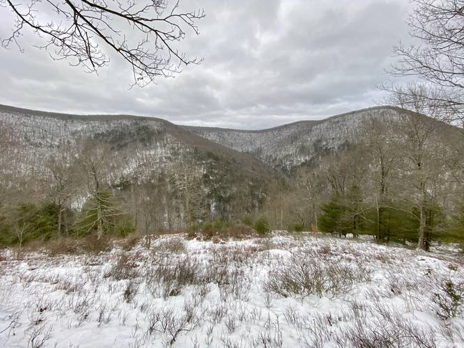
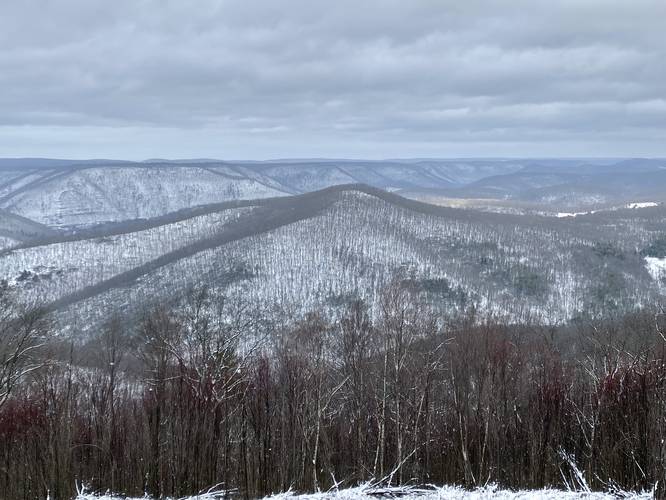
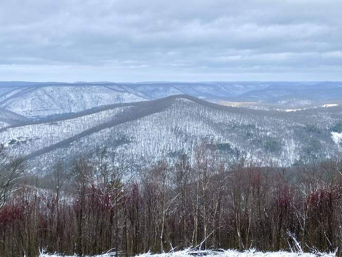
Hilborn Bowl Vista - Mile 1.25
Around mile 1.25, hikers will find a mountain ridge vista that faces eastward toward the mountain "bowl" that hikers will end up traversing around. This is a great spot to take a break from the grueling mountain climb and provides hikers with a view of the landscape they plan to encompass. Note that this mountain bowl is not like a typical bowl that's usually carved out from glaciers, but rather this bowl is comprised of three different mountain hollows with a ridgeline that spans all of them. After passing the Hilborn Bowl Vista, hikers will continue ascending the mountain along several steep grades with a couple of short "mountain benches" along the way (sorry, not actual benches).
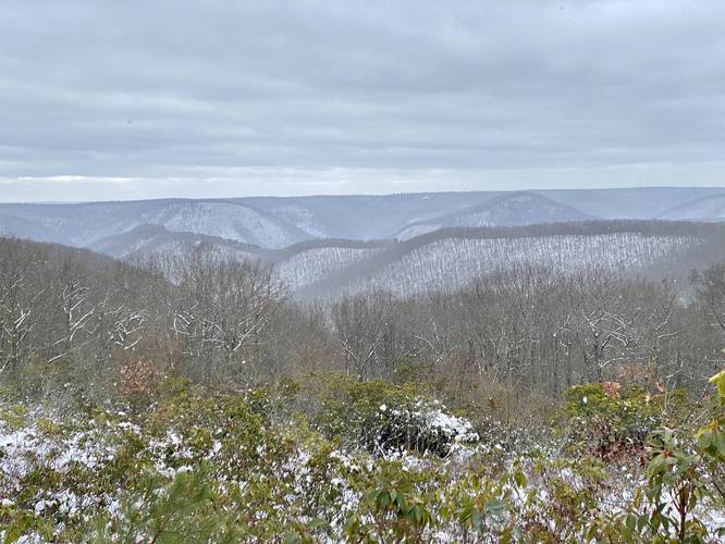
Hilborn Vista - Mile 1.8
At mile 1.8, hikers will reach another vista that faces west/southwest that sits high above the village of Hilborn, PA - hence the name, Hilborn Vista. From this view, a keen-eyed hiker may notice Hemlock Mountain, Half Dome Mountain (PA Half Dome), and other points-of-interest on the horizon or in the canyon below. Hikers will also get a view of Pine Creek from this vista.
Mountain Saddle - Mile 2.15 to 3
From miles 2.15 to 3, hikers will head down from the mostly-flat mountain summit and back down along a saddle that sits between one mountain summit and another. The hike back up the adjacent mountain is not difficult, but hikers will want to take a couple of breaks on the way up on their way toward the next vista.
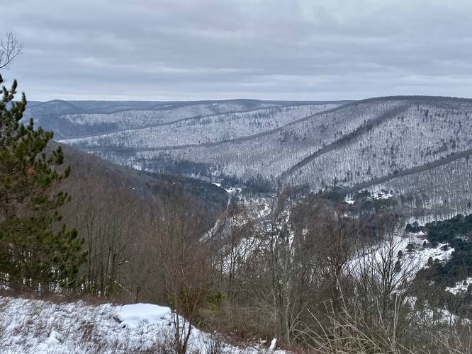
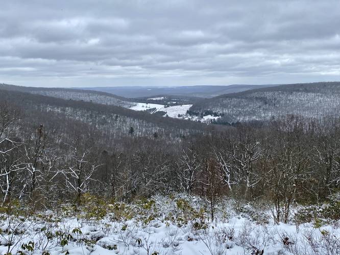
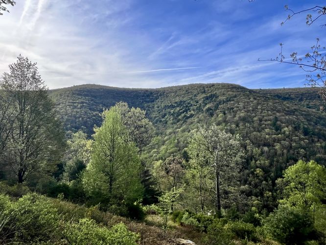
Twin Mountain Vista - Mile 3
At mile 3, hikers will reach, in my opinion, the best vista along this loop - Twin Mountain Vista. From the Twin Mountain Vista, hikers get stunning, ~120-degree views, of the PA Grand Canyon, Gillespie Point, Cedar Mountain (aka Grand View), and other mountains within Tioga, Lycoming, and potentially Bradford Counties (like Armenia Mountain). Hikers should hang out here for a while to take in the views before moving onward.
Service Road Hiking - Mile 3.25 to 4.4
After passing the Twin Mountain Vista, hikers will follow the wide trail downhill as it heads toward a service road junction. At this junction (approx. 0.25 miles from the view), hikers will follow an unnamed service road as it heads south toward the Golden Eagle Trail. This service road is not hard to hike on but has some undulation.
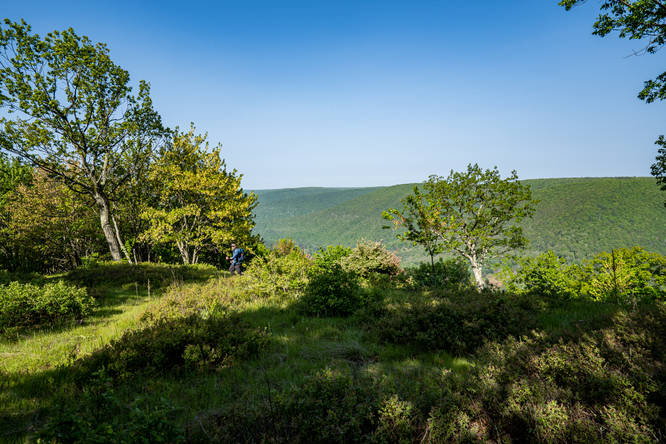
(Optional) Beulahland Vista - Mile 4.6
If the hiker follows the service road straight, they will end up following orange blazes (Golden Eagle Trail) accidentally, so be on the lookout for a large turn in the service road to mark the location of the turn to stay on the loop. Hikers can choose to hike along the Golden Eagle Trail (as depicted in this map) along a short out-and-back walk to the Beulahland Vista located around mile 4.6. Again, this is an optional view, but worth a stop and begins at mile 4.4 at the junction.
Bonnell Run Vista - Mile 4.83
After visiting the Beulahland Vista (or if passing it), hikers will follow the large bend in the service road as it heads west to reach the Bonnell Run Vista around mile 4.83. This is yet another view where keen-eyed hikers may spot several points-of-interest on the horizon including Hemlock Mountain, Half Dome Mountain (PA Half Dome), Quarry Mountain, and the mountainous ridge of the Dragon's Back Trail as it snakes its way south toward Quarry Mountain.
Hilborn Run Trail - Mile 5.08 to 6.45
After visiting the Bonnell Run Vista, hikers will head downhill along the unnamed service road for a short while before reaching a junction with the Hilborn Run Trail (right-hand side), Golden Eagle Trail (left-hand side), and the Dragon's Back Trail (straight, no trailhead sign). Here, obviously take a right-hand turn onto the Hilborn Run Trail. Note that the Hilborn Run Trail is not for the faint of heart as the trail follows a skinny path that runs along a very steep mountain slope. During the winter, if in deep layered snow, hiking this trail could be dangerous due to the potential to trigger an avalanche; however, the snowpack on this hike was a measly 4-inches, so the only danger was slipping and sliding. As you make your way down the Hilborn Run Trail, hikers will notice the trail sometimes has a slant that slopes toward the steep mountain slopes, so just watch your footing and if hiking in wet slippery or snowy conditions, it's best to take it slow or wear weather-appropriate footwear or gear (ex. ice spikes).
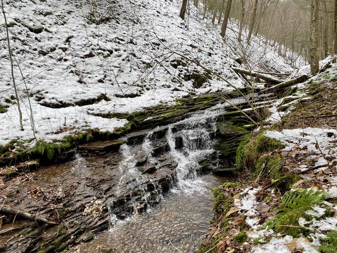
Hilborn Falls - Mile 6.1 / 6.28
At mile 6.1, hikers may notice Hilborn Falls, a 8-foot cascade that spills down Hilborn Run. There's an old log slide trail that leads down a couple of switchbacks where hikers can follow that to get a better view (as depicted in the GPS map), located at mile 6.2. If following this switchback trail to the waterfall, the waterfall will be located around mile 6.28.
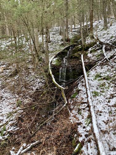
Hilborn Slide Falls - Mile 6.42
Just before leaving the Hilborn Trail is yet another waterfall, but mostly a slide waterfall, that cascades down Hilborn Run at about 7 or 8-feet tall, around mile 6.42. This is another spot to take in the scenery before hopping off of the trail. Note that this waterfall is visible from the bridge on the Pine Creek Trail.
Pine Creek Trail - Mile 6.45 to 7.3
Finally, hikers will reach the Pine Creek Trail around mile 6.45. Follow the path back to parking to complete your hike for approximately 7.3-miles if you hiked to the Beulahland Vista. Enjoy the scenery of Pine Creek and the PA Grand Canyon before heading.
Parking
Hikers will find a small parking turnout at the coordinates provided that sits adjacent to the Pine Creek Trail. The parking lot is located just south of the one-lane metal "singing" bridge that crosses Pine Creek. The lot is large enough to fit a half-dozen vehicles at most. Please do not overcrowd this small parking turnout.
Pets
Dogs are allowed if leashed and their waste should be carried out by the hiker.
Camping
Note that this hike follows State Game Lands for almost the entire way, which means camping is not allowed here.
Hazards
Steep terrain: Hikers should note the steep terrain not only on the initial mountain ascent along the Hilborn Trail, but also the steep mountain slopes that sit adjacent to the Hilborn Run Trail. Some of these steep slopes are not for the feint of heart or those who are afraid of heights. Note that for some steep sections during the winter, if there's layered snowpack, it's very smart to hike with an ice axe in case you need to suddenly self-arrest if you slip down one of these slopes.
Timber Rattlesnake: These woods are home to the Timber Rattlesnake and they generally roam between the months of late April to early October. Be on the lookout and give any snakes you find plenty of room.
Hunting: This hike follows paths that lead through hunting-specific areas. Wearing blaze orange is smart any time of the year.
Trails
This hike follows several named trails in the following order: Pine Creek Trail, Hilborn Trail, Unnamed Service Road, (optional) out-and-back hike down the Golden Eagle Trail, Unnamed Service Road, Hilborn Run Trail, and the Pine Creek Trail back to parking.
Hike Description
This hike begins along PA-414 just north of Slate Run in the village of Hilborn. Hikers will find a small parking turnout at the coordinates provided that sits adjacent to the Pine Creek Trail. The parking lot is located just south of the one-lane metal "singing" bridge that crosses Pine Creek.
Pine Creek Trail - Mile 0 to Mile 0.85
From the parking lot hikers will follow the flat Pine Creek Trail (rail trail) north as it passes several creeks and runs that spill down the mountainside. Some of these waterfalls are more seasonal - either they run after a heavy rain or snow melt; however, they're impossible to miss - most of the "free fall" cascades in these waterfalls is not much taller than 7-feet, but the water cascades down the mountainsides in multiple cascades and tiers.
Hilborn Trail - Mile 0.85
Around mile 0.85, hikers will reach Hilborn Run with a wooden bridge that spans the creek. Here, hikers will cross the bridge and then take a right-hand turn onto a very-steep and skinny path that begins your ascent up the mountain - the Hilborn Trail. This trail may be hard to see, but simply look at the steep hillside where the bridge's railing ends. The Hilborn Trail is very difficult along this mountain ridge and should be considered Difficult (Hard) to Strenuous, depending on your hiking skill level. This trail ascends the mountain ridge and includes several rocky outcroppings along the way.
Hilborn Bowl Vista - Mile 1.25
Around mile 1.25, hikers will find a mountain ridge vista that faces eastward toward the mountain "bowl" that hikers will end up traversing around. This is a great spot to take a break from the grueling mountain climb and provides hikers with a view of the landscape they plan to encompass. Note that this mountain bowl is not like a typical bowl that's usually carved out from glaciers, but rather this bowl is comprised of three different mountain hollows with a ridgeline that spans all of them. After passing the Hilborn Bowl Vista, hikers will continue ascending the mountain along several steep grades with a couple of short "mountain benches" along the way (sorry, not actual benches).
Hilborn Vista - Mile 1.8
At mile 1.8, hikers will reach another vista that faces west/southwest that sits high above the village of Hilborn, PA - hence the name, Hilborn Vista. From this view, a keen-eyed hiker may notice Hemlock Mountain, Half Dome Mountain (PA Half Dome), and other points-of-interest on the horizon or in the canyon below. Hikers will also get a view of Pine Creek from this vista.
Mountain Saddle - Mile 2.15 to 3
From miles 2.15 to 3, hikers will head down from the mostly-flat mountain summit and back down along a saddle that sits between one mountain summit and another. The hike back up the adjacent mountain is not difficult, but hikers will want to take a couple of breaks on the way up on their way toward the next vista.
Twin Mountain Vista - Mile 3
At mile 3, hikers will reach, in my opinion, the best vista along this loop - Twin Mountain Vista. From the Twin Mountain Vista, hikers get stunning, ~120-degree views, of the PA Grand Canyon, Gillespie Point, Cedar Mountain (aka Grand View), and other mountains within Tioga, Lycoming, and potentially Bradford Counties (like Armenia Mountain). Hikers should hang out here for a while to take in the views before moving onward.
Service Road Hiking - Mile 3.25 to 4.4
After passing the Twin Mountain Vista, hikers will follow the wide trail downhill as it heads toward a service road junction. At this junction (approx. 0.25 miles from the view), hikers will follow an unnamed service road as it heads south toward the Golden Eagle Trail. This service road is not hard to hike on but has some undulation.
(Optional) Beulahland Vista - Mile 4.6
If the hiker follows the service road straight, they will end up following orange blazes (Golden Eagle Trail) accidentally, so be on the lookout for a large turn in the service road to mark the location of the turn to stay on the loop. Hikers can choose to hike along the Golden Eagle Trail (as depicted in this map) along a short out-and-back walk to the Beulahland Vista located around mile 4.6. Again, this is an optional view, but worth a stop and begins at mile 4.4 at the junction.
Bonnell Run Vista - Mile 4.83
After visiting the Beulahland Vista (or if passing it), hikers will follow the large bend in the service road as it heads west to reach the Bonnell Run Vista around mile 4.83. This is yet another view where keen-eyed hikers may spot several points-of-interest on the horizon including Hemlock Mountain, Half Dome Mountain (PA Half Dome), Quarry Mountain, and the mountainous ridge of the Dragon's Back Trail as it snakes its way south toward Quarry Mountain.
Hilborn Run Trail - Mile 5.08 to 6.45
After visiting the Bonnell Run Vista, hikers will head downhill along the unnamed service road for a short while before reaching a junction with the Hilborn Run Trail (right-hand side), Golden Eagle Trail (left-hand side), and the Dragon's Back Trail (straight, no trailhead sign). Here, obviously take a right-hand turn onto the Hilborn Run Trail. Note that the Hilborn Run Trail is not for the faint of heart as the trail follows a skinny path that runs along a very steep mountain slope. During the winter, if in deep layered snow, hiking this trail could be dangerous due to the potential to trigger an avalanche; however, the snowpack on this hike was a measly 4-inches, so the only danger was slipping and sliding. As you make your way down the Hilborn Run Trail, hikers will notice the trail sometimes has a slant that slopes toward the steep mountain slopes, so just watch your footing and if hiking in wet slippery or snowy conditions, it's best to take it slow or wear weather-appropriate footwear or gear (ex. ice spikes).
Hilborn Falls - Mile 6.1 / 6.28
At mile 6.1, hikers may notice Hilborn Falls, a 8-foot cascade that spills down Hilborn Run. There's an old log slide trail that leads down a couple of switchbacks where hikers can follow that to get a better view (as depicted in the GPS map), located at mile 6.2. If following this switchback trail to the waterfall, the waterfall will be located around mile 6.28.
Hilborn Slide Falls - Mile 6.42
Just before leaving the Hilborn Trail is yet another waterfall, but mostly a slide waterfall, that cascades down Hilborn Run at about 7 or 8-feet tall, around mile 6.42. This is another spot to take in the scenery before hopping off of the trail. Note that this waterfall is visible from the bridge on the Pine Creek Trail.
Pine Creek Trail - Mile 6.45 to 7.3
Finally, hikers will reach the Pine Creek Trail around mile 6.45. Follow the path back to parking to complete your hike for approximately 7.3-miles if you hiked to the Beulahland Vista. Enjoy the scenery of Pine Creek and the PA Grand Canyon before heading.
Parking
Hikers will find a small parking turnout at the coordinates provided that sits adjacent to the Pine Creek Trail. The parking lot is located just south of the one-lane metal "singing" bridge that crosses Pine Creek. The lot is large enough to fit a half-dozen vehicles at most. Please do not overcrowd this small parking turnout.
Pets
Dogs are allowed if leashed and their waste should be carried out by the hiker.
Camping
Note that this hike follows State Game Lands for almost the entire way, which means camping is not allowed here.
Hazards
Steep terrain: Hikers should note the steep terrain not only on the initial mountain ascent along the Hilborn Trail, but also the steep mountain slopes that sit adjacent to the Hilborn Run Trail. Some of these steep slopes are not for the feint of heart or those who are afraid of heights. Note that for some steep sections during the winter, if there's layered snowpack, it's very smart to hike with an ice axe in case you need to suddenly self-arrest if you slip down one of these slopes.
Timber Rattlesnake: These woods are home to the Timber Rattlesnake and they generally roam between the months of late April to early October. Be on the lookout and give any snakes you find plenty of room.
Hunting: This hike follows paths that lead through hunting-specific areas. Wearing blaze orange is smart any time of the year.