The Pitch Pine Loop Ski Trail at Tiadaghton State Forest near Cammal, Pennsylvania is an easy 2.6-mile loop trail that features a beautiful vista point of the mountains within the Miller Run Natural Area, just west of the Pennsylvania Grand Canyon.
Trail Description
This hike begins at the only trailhead for this trail located right off of PA-44 at the parking coordinates provided. There's a short spur trail that connects the trailhead to the main loop that can be found right behind the trailhead sign. Hikers should follow this short spur trail until they reach the blue blaze markers. This recording follows the loop in a counter clockwise direction, hence the notes will include information following this route.
On the eastern side of the loop, the trail passes through a mixed forest of deciduous trees, large ferns, blueberry and huckleberry bushes, and other low-growing shrubs before reaching a service road. This service road leads into a natural gas extraction site, which appears to have been hooked into a gas line as there are no longer any extraction equipment left over. This section of the trail is teaming with wildflowers during mid-Summer, making this a haven for butterflies. Follow the blue blaze markers east, hiking along the road for about 300-feet, before turning off and heading back into the woods.
The trail will meander its way through a slightly more dense forest as hikers approach the vista point from the eastern half of the loop, but plenty of blueberry and huckleberry bushes can still be found along the way.
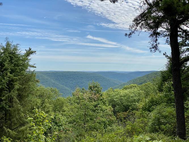
Reaching the Vista Point
Hikers will reach the vista point around mile 1.1, which is approximately half-way through this easy loop trail. As of August 2020, there was a nice wooden bench that hikers can use to relax with a view of the Miller Run Natural Area - a southern section of mountains due-west of the Pennsylvania Grand Canyon (officially named Pine Creek Gorge).
The hike from the vista point back to parking along the western half of the loop is just as easy as hiking the eastern half. The forest along the western half is more dense, but hikers will still pass plenty of huckleberry and blueberry bushes, which are often ripe during mid-Summer.
Trail Registry
Just before reaching the parking lot, hikers will find the trail registry box. If you hike this trail clockwise, you'll reach this almost immediately after starting the loop.
Parking
Hikers will find a parking lot at the coordinates provided -- large enough to fit about six vehicles.
Pets
Dogs are allowed if leashed.
Blaze Color
This trail follows blue plastic blazes with black arrows, as of August 2020.
Camping and Backpacking
While this trail does not have any designated campsites along the way, backpackers can setup camp off-trail if they follow the Tiadaghton State Forest backcountry / primitive / dispersed camping rules.
Private Property Adjacent
There's a private residence located next to this trail and the parking area. Please be respectful of the locals and their property / space.
Trail Description
This hike begins at the only trailhead for this trail located right off of PA-44 at the parking coordinates provided. There's a short spur trail that connects the trailhead to the main loop that can be found right behind the trailhead sign. Hikers should follow this short spur trail until they reach the blue blaze markers. This recording follows the loop in a counter clockwise direction, hence the notes will include information following this route.
On the eastern side of the loop, the trail passes through a mixed forest of deciduous trees, large ferns, blueberry and huckleberry bushes, and other low-growing shrubs before reaching a service road. This service road leads into a natural gas extraction site, which appears to have been hooked into a gas line as there are no longer any extraction equipment left over. This section of the trail is teaming with wildflowers during mid-Summer, making this a haven for butterflies. Follow the blue blaze markers east, hiking along the road for about 300-feet, before turning off and heading back into the woods.
The trail will meander its way through a slightly more dense forest as hikers approach the vista point from the eastern half of the loop, but plenty of blueberry and huckleberry bushes can still be found along the way.
Reaching the Vista Point
Hikers will reach the vista point around mile 1.1, which is approximately half-way through this easy loop trail. As of August 2020, there was a nice wooden bench that hikers can use to relax with a view of the Miller Run Natural Area - a southern section of mountains due-west of the Pennsylvania Grand Canyon (officially named Pine Creek Gorge).
The hike from the vista point back to parking along the western half of the loop is just as easy as hiking the eastern half. The forest along the western half is more dense, but hikers will still pass plenty of huckleberry and blueberry bushes, which are often ripe during mid-Summer.
Trail Registry
Just before reaching the parking lot, hikers will find the trail registry box. If you hike this trail clockwise, you'll reach this almost immediately after starting the loop.
Parking
Hikers will find a parking lot at the coordinates provided -- large enough to fit about six vehicles.
Pets
Dogs are allowed if leashed.
Blaze Color
This trail follows blue plastic blazes with black arrows, as of August 2020.
Camping and Backpacking
While this trail does not have any designated campsites along the way, backpackers can setup camp off-trail if they follow the Tiadaghton State Forest backcountry / primitive / dispersed camping rules.
Private Property Adjacent
There's a private residence located next to this trail and the parking area. Please be respectful of the locals and their property / space.