The Bull Run Point Vistas at Tioga State Forest near Cedar Run, Pennsylvania is a difficult 2.3-mile out-and-back hike that leads to off-trail views of the PA Grand Canyon from Bull Run Point.
Trails
This hike follows one named trail, Chimney Rock Trail (yellow blazes), and also includes an off-trail bushwhack that leads through rattlesnake territory and down the mountain.
Hike Description
Hikers will begin this journey at the Chimney Rock Trail at the parking lot where they'll follow this mostly-flat yellow-blazed trail as it winds its way through pine trees, mountain laurel, and blueberry bushes that line the forest floor.
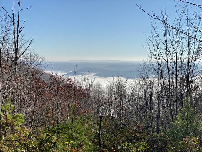
Canyon Vista - Mile 0.4
Around mile 0.4, hikers will reach an easterly view that peers into the PA Grand Canyon.
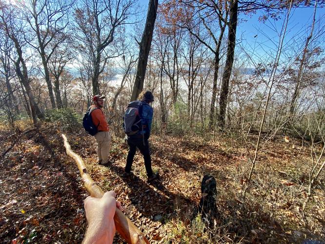
Left-Hand Turn to Bushwhack - Mile 0.65
Around mile 0.65, hikers will reach a 90-degree right-hand bend in the yellow blazed Chimney Rock Trail. This is where hikers will want to take a left-hand turn to start their off-trail bushwhack. As of November, 2022 (and earlier), there's a deer trail here that begins and then quickly disappears. The easiest way to hike here is to follow the mostly-flat mountain ridge out to a rocky outcropping (potentially a rattlesnake den) to then descend the mountain's ridge down to Bull Run Point. The GPS track provided accidentally heads downhill too soon and then heads up the rocky outcropping to descend, but your main goal is to hike down the mountain ridge.
Mountain Ridge Descent - 0.8 to 0.95
At mile 0.8, hikers will begin their descent to Bull Run Point by following the steep mountain ridge. The hike down is not necessarily difficult, but after a while, your knees begin to really feel the elevation change. For less pain, try making your own switchbacks on the way down - the forest floor is very open and easy to navigate here. Trekking poles also help a lot for this section of the hike.
Bull Run Point - Mile 1
At mile 1, hikers will essentially be on Bull Run Point, which is a large bench on Cedar Mountain that juts into the middle of the PA Grand Canyon, high above Pine Creek. Once on Bull Run Point, the hike becomes a lot more interesting.
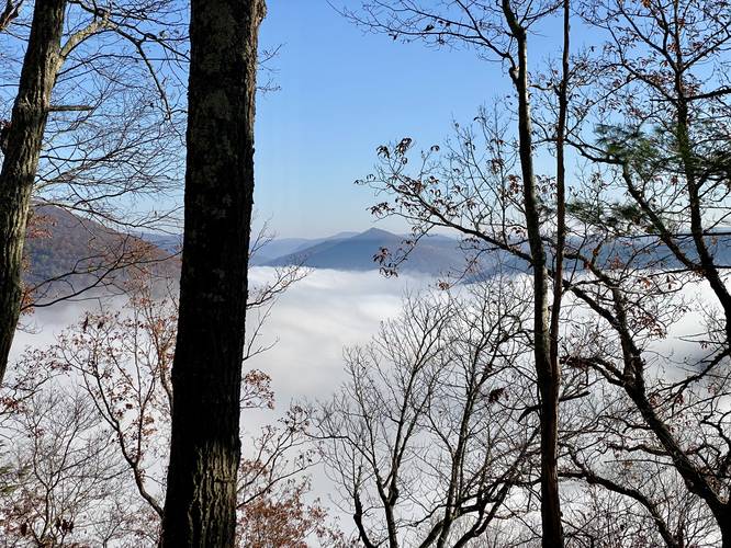
Northeast Vista - Mile 1.1
At mile 1.1, on the eastern side of Bull Run Point, lies a seasonal and obstructed view of Pine Creek, the PA Grand Canyon, and the "PA Pyramid" - known as Gillespie Point. This view can only be appreciated when the leaves are fully off of the trees though. This view, while obstructed, is a personal favorite. Don't give up just yet as there's a wide-open view found at a rock field located on the western side of Bull Run Point not far from here.
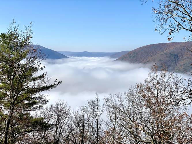
Bull Run Point Southwest Vista - Mile 1.16
After visiting the obstructed Northeast Vista, hikers can head down the point a bit further. On the way down, check the western side of Bull Run Point for a single boulder that sits on the side of the mountain - this boulder is not much larger than 6-feet x 6-feet wide; however, at the boulder is a beautiful southwest-facing view of the PA Grand Canyon. The hike down the boulder is very steep, so watch your footing. This slate rock field is the perfect place for a vista as only a couple small pine trees have attempted to grow on the steep rocky slopes - keeping this part of the mountain bare. It's also a perfect spot for rattlesnakes to live and den, so it's very likely this vista is in fact a rattlesnake habitat - and another reason to save this hike for a cold day. Enjoy the view for as long as you wish before starting your hike back up the mountain, especially if visiting in the early morning when the fog sits within the canyon.
Hiking Out
While not easy, the hike out is fairly straight forward, assuming you're good with off-trail navigation. The hike up the mountain is pretty difficult despite the total mileage to ascend the ~500-feet back up from Bull Run Point, so take your time.
Seasonal Access (Cold Temps Recommended)
Please note that this particular hike and parking lot are only accessible after the snow has melted - usually in late April - and before the snow and ice build up - usually before December each year. Also note that the views are better with the leaves off the trees and is best to hike when it's cold outside to prevent stepping on Rattlesnakes as these rocky outcroppings are likely home to the Timber Rattlesnake.
Parking
Hikers will find a large parking lot at the coordinates provided. Please note that Old Mountain Road is a very long dirt road that's used primarily by hunters, large logging trucks, and forestry personnel, which means that unless the road has been recently graded and fixed, sometimes this road is literally impassible without a 4-wheel drive vehicle with high clearance (preferably a truck). As of November, 2022, this road is perfectly fine to travel without a vehicle with a high clearance; however, that's not always the case. An alternative parking lot can be found along PA-414 which requires a 1-mile, 1,000-foot hike up to the top of the mountain via the Bull Run Trail - hikers can find directions to that parking lot and the hike described on our Chimney Rock Vista Hike guide which follows the Bull Run Trail. Drive at your own risk.
Warning
Timber Rattlesnake: The Timber Rattlesnake calls this area home and is generally out roaming the forest between late April and early October. Due to the rocky outcroppings, it's very likely that these rocks provide dens and shelter for these snakes. It's best to hike this trail when it's cold to try and avoid them. If you find a rattlesnake, please give it plenty of space.
Bushwhacking: Note that about half of this hike heads through the woods and does not follow any trail or direct path. This hike is meant for folks with off-trail navigation experience. It's smart to use an offline mapping tool or app just in case.
Parking: Please read the parking notes before you head out.
Hunting: Hunting is allowed here so it's smart to wear blaze orange during hunting season. On this hike, we ran into a hunter in a stand located just before the descent to Bull Run Point on the ridge, so you never know if you'll run into a hunter!
History - Bull Run Fire
Hikers may notice charred trees and other signs of forest fires along this hike like open forest spaces and low growing bushes and trees. The low-growth mountain laurel, blueberry bushes, and young forests are all the result of the 2008 wildfire named the Bull Run Fire. Copied from the Tioga State Forest PDF: "In April 2008 a fire called the Bull Run Fire started on Rt. 414 south of Blackwell and raced up Bull Run Hollow. It burned for a week, traveling 2.5 miles, devastating almost 4000 forested acres. Approximately 150 fire fighters battled the blaze. Air tankers helped the fire fighters contain the massive fire that had flames at times as high as 35 feet. After the fire, large scale logging efforts took place to salvage usable wood products. Today a new forest is growing rapidly, but you can still see the charred remains of what was once there. Use caution and be aware of dead trees!"
Note to Chuck Dillon's 2011 Book & "Chimney Rock"
I found this hike originally in Chuck Dillon's 2011 book titled "Short Hikes in Pennsylvania's Grand Canyon Fourth Edition" so all credit goes to him; however, please note that I also attempted to find the location of his "Chimney Rock" which the book labels is just beyond the 3rd mountain drainage from Bull Run Point but I was unable to locate it. In fact, there doesn't appear to be any rocky outcropping or view near or just beyond the 3rd drainage. Looking down the mountain and beyond the 4th drainage does not appear to be any "Chimney Rock" either, so I think what happened was Chuck miscounted the number of drains he passed before finding the popular Chimney Rock located beyond the 6th drainage. Unless time, erosion, or an event happened between 2011 and 2022, I don't see how a 2nd "Chimney Rock" with a vista would have ever existed in the location that his book describes. I mention this so people who read his book don't go out and waste an additional 2 miles of energy to try and find it. The rock you're looking for is in our Chimney Rock Vista Hike guide.
Trails
This hike follows one named trail, Chimney Rock Trail (yellow blazes), and also includes an off-trail bushwhack that leads through rattlesnake territory and down the mountain.
Hike Description
Hikers will begin this journey at the Chimney Rock Trail at the parking lot where they'll follow this mostly-flat yellow-blazed trail as it winds its way through pine trees, mountain laurel, and blueberry bushes that line the forest floor.
Canyon Vista - Mile 0.4
Around mile 0.4, hikers will reach an easterly view that peers into the PA Grand Canyon.
Left-Hand Turn to Bushwhack - Mile 0.65
Around mile 0.65, hikers will reach a 90-degree right-hand bend in the yellow blazed Chimney Rock Trail. This is where hikers will want to take a left-hand turn to start their off-trail bushwhack. As of November, 2022 (and earlier), there's a deer trail here that begins and then quickly disappears. The easiest way to hike here is to follow the mostly-flat mountain ridge out to a rocky outcropping (potentially a rattlesnake den) to then descend the mountain's ridge down to Bull Run Point. The GPS track provided accidentally heads downhill too soon and then heads up the rocky outcropping to descend, but your main goal is to hike down the mountain ridge.
Mountain Ridge Descent - 0.8 to 0.95
At mile 0.8, hikers will begin their descent to Bull Run Point by following the steep mountain ridge. The hike down is not necessarily difficult, but after a while, your knees begin to really feel the elevation change. For less pain, try making your own switchbacks on the way down - the forest floor is very open and easy to navigate here. Trekking poles also help a lot for this section of the hike.
Bull Run Point - Mile 1
At mile 1, hikers will essentially be on Bull Run Point, which is a large bench on Cedar Mountain that juts into the middle of the PA Grand Canyon, high above Pine Creek. Once on Bull Run Point, the hike becomes a lot more interesting.
Northeast Vista - Mile 1.1
At mile 1.1, on the eastern side of Bull Run Point, lies a seasonal and obstructed view of Pine Creek, the PA Grand Canyon, and the "PA Pyramid" - known as Gillespie Point. This view can only be appreciated when the leaves are fully off of the trees though. This view, while obstructed, is a personal favorite. Don't give up just yet as there's a wide-open view found at a rock field located on the western side of Bull Run Point not far from here.
Bull Run Point Southwest Vista - Mile 1.16
After visiting the obstructed Northeast Vista, hikers can head down the point a bit further. On the way down, check the western side of Bull Run Point for a single boulder that sits on the side of the mountain - this boulder is not much larger than 6-feet x 6-feet wide; however, at the boulder is a beautiful southwest-facing view of the PA Grand Canyon. The hike down the boulder is very steep, so watch your footing. This slate rock field is the perfect place for a vista as only a couple small pine trees have attempted to grow on the steep rocky slopes - keeping this part of the mountain bare. It's also a perfect spot for rattlesnakes to live and den, so it's very likely this vista is in fact a rattlesnake habitat - and another reason to save this hike for a cold day. Enjoy the view for as long as you wish before starting your hike back up the mountain, especially if visiting in the early morning when the fog sits within the canyon.
Hiking Out
While not easy, the hike out is fairly straight forward, assuming you're good with off-trail navigation. The hike up the mountain is pretty difficult despite the total mileage to ascend the ~500-feet back up from Bull Run Point, so take your time.
Seasonal Access (Cold Temps Recommended)
Please note that this particular hike and parking lot are only accessible after the snow has melted - usually in late April - and before the snow and ice build up - usually before December each year. Also note that the views are better with the leaves off the trees and is best to hike when it's cold outside to prevent stepping on Rattlesnakes as these rocky outcroppings are likely home to the Timber Rattlesnake.
Parking
Hikers will find a large parking lot at the coordinates provided. Please note that Old Mountain Road is a very long dirt road that's used primarily by hunters, large logging trucks, and forestry personnel, which means that unless the road has been recently graded and fixed, sometimes this road is literally impassible without a 4-wheel drive vehicle with high clearance (preferably a truck). As of November, 2022, this road is perfectly fine to travel without a vehicle with a high clearance; however, that's not always the case. An alternative parking lot can be found along PA-414 which requires a 1-mile, 1,000-foot hike up to the top of the mountain via the Bull Run Trail - hikers can find directions to that parking lot and the hike described on our Chimney Rock Vista Hike guide which follows the Bull Run Trail. Drive at your own risk.
Warning
Timber Rattlesnake: The Timber Rattlesnake calls this area home and is generally out roaming the forest between late April and early October. Due to the rocky outcroppings, it's very likely that these rocks provide dens and shelter for these snakes. It's best to hike this trail when it's cold to try and avoid them. If you find a rattlesnake, please give it plenty of space.
Bushwhacking: Note that about half of this hike heads through the woods and does not follow any trail or direct path. This hike is meant for folks with off-trail navigation experience. It's smart to use an offline mapping tool or app just in case.
Parking: Please read the parking notes before you head out.
Hunting: Hunting is allowed here so it's smart to wear blaze orange during hunting season. On this hike, we ran into a hunter in a stand located just before the descent to Bull Run Point on the ridge, so you never know if you'll run into a hunter!
History - Bull Run Fire
Hikers may notice charred trees and other signs of forest fires along this hike like open forest spaces and low growing bushes and trees. The low-growth mountain laurel, blueberry bushes, and young forests are all the result of the 2008 wildfire named the Bull Run Fire. Copied from the Tioga State Forest PDF: "In April 2008 a fire called the Bull Run Fire started on Rt. 414 south of Blackwell and raced up Bull Run Hollow. It burned for a week, traveling 2.5 miles, devastating almost 4000 forested acres. Approximately 150 fire fighters battled the blaze. Air tankers helped the fire fighters contain the massive fire that had flames at times as high as 35 feet. After the fire, large scale logging efforts took place to salvage usable wood products. Today a new forest is growing rapidly, but you can still see the charred remains of what was once there. Use caution and be aware of dead trees!"
Note to Chuck Dillon's 2011 Book & "Chimney Rock"
I found this hike originally in Chuck Dillon's 2011 book titled "Short Hikes in Pennsylvania's Grand Canyon Fourth Edition" so all credit goes to him; however, please note that I also attempted to find the location of his "Chimney Rock" which the book labels is just beyond the 3rd mountain drainage from Bull Run Point but I was unable to locate it. In fact, there doesn't appear to be any rocky outcropping or view near or just beyond the 3rd drainage. Looking down the mountain and beyond the 4th drainage does not appear to be any "Chimney Rock" either, so I think what happened was Chuck miscounted the number of drains he passed before finding the popular Chimney Rock located beyond the 6th drainage. Unless time, erosion, or an event happened between 2011 and 2022, I don't see how a 2nd "Chimney Rock" with a vista would have ever existed in the location that his book describes. I mention this so people who read his book don't go out and waste an additional 2 miles of energy to try and find it. The rock you're looking for is in our Chimney Rock Vista Hike guide.