The Devil's Overlook Trail at Black Canyon of the Gunnison National Park
near Montrose, Colorado is a moderate 0.6-mile out-and-back hike that
features views of the Black Canyon from the Devil's Overlook.
Hike
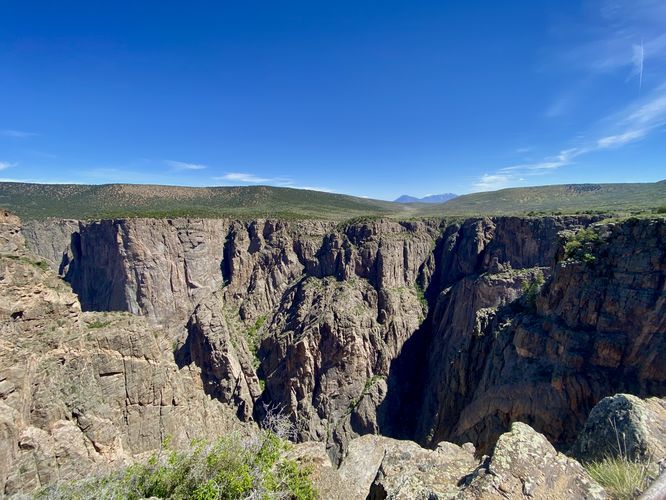
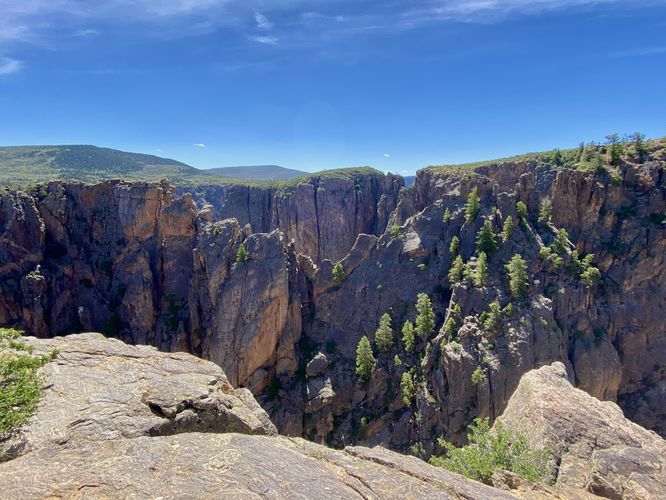
This trail begins at the main trailhead for the Devil's Overlook and leads downhill through the low-growing scrubland and shrubs of the Black Canyon's south rim. Along the way down, hikers will find views of the West Elk Mountains as they sit in the background above the north rim of the canyon. The trail eventually reaches a large rocky outcropping around mile 0.25 where you'll find neat views looking southeast of the canyon's jagged cliff-riddled terrain with shrubs and juniper trees growing within. This view was my personal favorite, but the main Devil's Overlook is located down the trail from here. Around mile 0.3, hikers will reach the Devil's Overlook -- from here, you can peer into the canyon looking northward. The view from the Devil's Overlook, in my opinion, was less stunning than other overlooks along the south rim, which might be why this trail was quiet and I was the only hiker on it for at least 15 minutes during a busy weekend morning. The hike back is mostly all uphill, hence the moderate difficulty, and ends at the main parking turnout at mile 0.6.
Other South Rim Trails
Black Canyon Gunnison National Park's south rim is by far the most popular section of the park for visitors to explore. For popular day hikes, consider checking out Gunnison Point for stunning canyon views or hike the adjacent Oak Flat Loop Trail that descends into the gorge. You can then hike the Uplands Trail to reach the Rim Rock Trail which runs along the south rim and provides stunning views of the canyon along the way. To the west, at the end of the park's road, lies the Warner Point Trail which provides hikers with another moderate hike to a overlook that sits above the deepest section of Black Canyon. The rest of the trails along the south rim are very short hikes or simply peaceful nature walks that lead to views. Plan your trip to the Black Canyon by checking out our guides to each of the short overlooks along the south rim - starting from west to east: Sunset View, Dragon Point, Cedar Point, Painted Wall View, Chasm View, Devil's Overlook, Rock Point, Cross Fissures View, and Pulpit Rock.
Pets
Dogs are allowed on this trail only if leashed and must be cleaned up after. Note that dogs are only allowed in parking lots, campgrounds, on paths to overlooks (like this one), the Rim Rock Trail, and the Chasm View Nature Trail. Dogs are not permitted on any other trails in the park. You can read all of the rules and regulations for pets at the park here.
Parking
Hikers will find a parking turnout at the coordinates provided, located along South Rim Road in the park. The lot is large enough to fit less than a dozen vehicles as of June 2024.
Warnings
Steep cliffs: Despite the abundance of safety precautions (i.e. fencing), this trail leads to cliffs that might drop 2,000-feet or more into the Black Canyon. Be aware of your surroundings.
Sun exposure: This trail has very-little shade and also sits at about 8,000-feet above sea level which increases the UV index. It's smart to wear sunscreen and bring extra sun protection when hiking this trail and other trails at Black Canyon of the Gunnison National Park.
Elevation sickness: This trail brings hikers through an altitude of about 8,000-feet above sea level. Around the 7,000-foot mark above sea level, you may start to experience symptoms of elevation sickness including shortness of breath, headaches, muscle aches, dizziness, rapid heartbeat, fatigue, or vomiting if you are not fully acclimated. If you're experiencing bad altitude sickness symptoms, the smartest move is to get to lower elevation as soon as possible.
Hike
This trail begins at the main trailhead for the Devil's Overlook and leads downhill through the low-growing scrubland and shrubs of the Black Canyon's south rim. Along the way down, hikers will find views of the West Elk Mountains as they sit in the background above the north rim of the canyon. The trail eventually reaches a large rocky outcropping around mile 0.25 where you'll find neat views looking southeast of the canyon's jagged cliff-riddled terrain with shrubs and juniper trees growing within. This view was my personal favorite, but the main Devil's Overlook is located down the trail from here. Around mile 0.3, hikers will reach the Devil's Overlook -- from here, you can peer into the canyon looking northward. The view from the Devil's Overlook, in my opinion, was less stunning than other overlooks along the south rim, which might be why this trail was quiet and I was the only hiker on it for at least 15 minutes during a busy weekend morning. The hike back is mostly all uphill, hence the moderate difficulty, and ends at the main parking turnout at mile 0.6.
Other South Rim Trails
Black Canyon Gunnison National Park's south rim is by far the most popular section of the park for visitors to explore. For popular day hikes, consider checking out Gunnison Point for stunning canyon views or hike the adjacent Oak Flat Loop Trail that descends into the gorge. You can then hike the Uplands Trail to reach the Rim Rock Trail which runs along the south rim and provides stunning views of the canyon along the way. To the west, at the end of the park's road, lies the Warner Point Trail which provides hikers with another moderate hike to a overlook that sits above the deepest section of Black Canyon. The rest of the trails along the south rim are very short hikes or simply peaceful nature walks that lead to views. Plan your trip to the Black Canyon by checking out our guides to each of the short overlooks along the south rim - starting from west to east: Sunset View, Dragon Point, Cedar Point, Painted Wall View, Chasm View, Devil's Overlook, Rock Point, Cross Fissures View, and Pulpit Rock.
Pets
Dogs are allowed on this trail only if leashed and must be cleaned up after. Note that dogs are only allowed in parking lots, campgrounds, on paths to overlooks (like this one), the Rim Rock Trail, and the Chasm View Nature Trail. Dogs are not permitted on any other trails in the park. You can read all of the rules and regulations for pets at the park here.
Parking
Hikers will find a parking turnout at the coordinates provided, located along South Rim Road in the park. The lot is large enough to fit less than a dozen vehicles as of June 2024.
Warnings
Steep cliffs: Despite the abundance of safety precautions (i.e. fencing), this trail leads to cliffs that might drop 2,000-feet or more into the Black Canyon. Be aware of your surroundings.
Sun exposure: This trail has very-little shade and also sits at about 8,000-feet above sea level which increases the UV index. It's smart to wear sunscreen and bring extra sun protection when hiking this trail and other trails at Black Canyon of the Gunnison National Park.
Elevation sickness: This trail brings hikers through an altitude of about 8,000-feet above sea level. Around the 7,000-foot mark above sea level, you may start to experience symptoms of elevation sickness including shortness of breath, headaches, muscle aches, dizziness, rapid heartbeat, fatigue, or vomiting if you are not fully acclimated. If you're experiencing bad altitude sickness symptoms, the smartest move is to get to lower elevation as soon as possible.