The Gunnison Point Trail at Black Canyon of the Gunnison National Park near Montrose, Colorado is an easy 0.3-mile out-and-back walk that leads to several stunning overlooks with views that peer into the 2,000-foot deep Black Canyon.
Walk
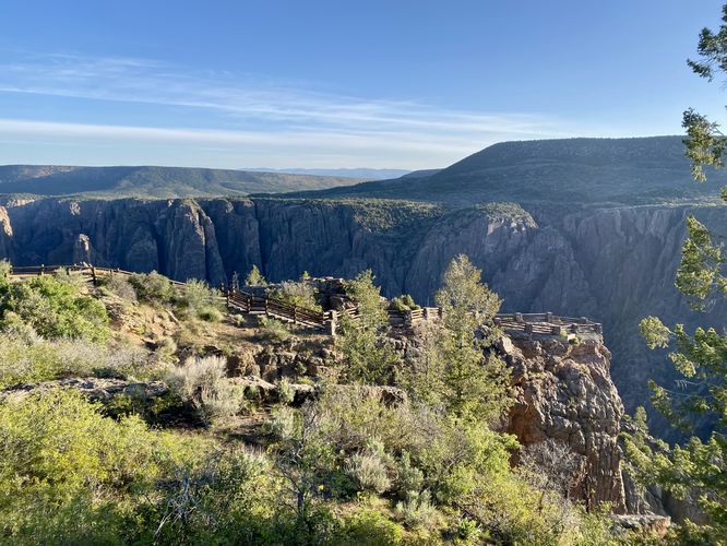
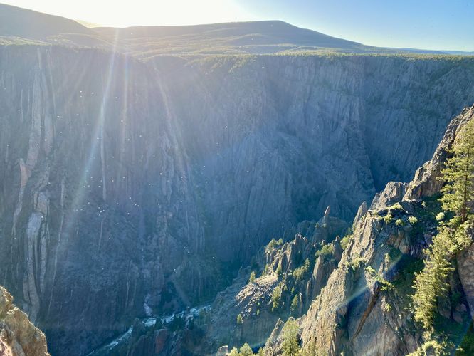
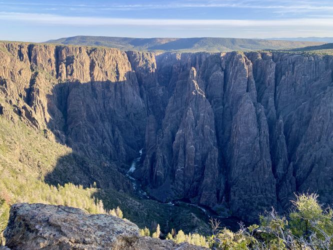
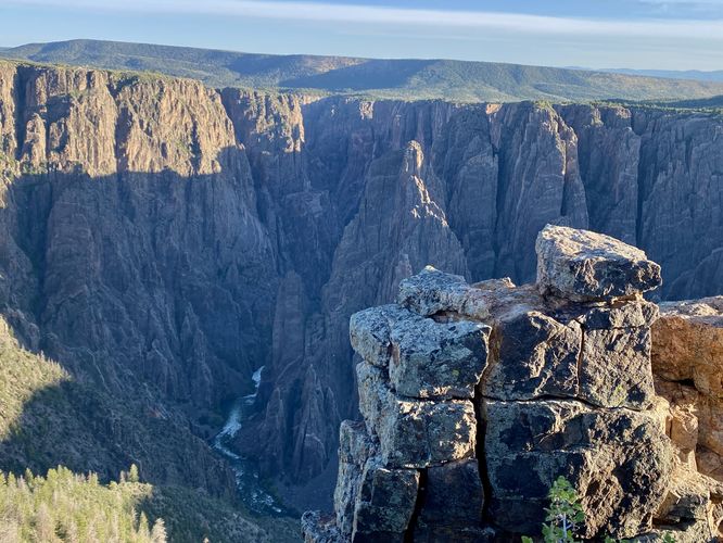
This walk being at the main visitors center and leads into the trailhead via the western deck of the building. The trail leads behind the building and turns east and west at a trail junction that's just a stone's throw away from the visitors center. This route leads to the east to reach the jutting overlook that sits high above the rim of the Black Canyon. During our hike here in the very-early morning of early June 2024, the morning sunlight drowned-out most of the views of the Black Canyon from this overlook -- so this spot is a bit nicer later in the day once the sun has come up to illuminate the inner depths of the canyon. Regardless, this first stop was stunning - we had views facing northwest into the canyon where we could see the Gunnison River roaring through the gorge below with its water almost constantly churning in white water rapids.
Next, we walked west to checkout the other side of Gunnison Point. The trail leads west, where you might find a small "loop" that connects at the junction - this loop is just an offshoot path that hikers have maybe accidentally walked through and can be found in the route provided. Regardless, once on the west side of Gunnison Point, you'll find a couple of overlook spots - one of which does not have any fencing, so be careful. The views from both lookouts on the west side of Gunnison Point provide similar stunning views that you first saw from the eastern overlook; however, these views are exclusively that of the northwest corridor of the canyon. Here, you can watch the Gunnison River cut its way through the gorge with the roar of the water sent up the 2,000-foot tall cliff sides.
After exploring both views, the walk back to parking follows that weird "loop" offshoot trail to reach the junction before heading south to the visitors center. We then hopped on the Flat Oak Loop Trail to explore more of what the Black Canyon had to offer us. The trailhead for the Flat Oak Loop Trail can be found near the trailhead for Gunnison Point.
Other Hikes
While checking out Gunnison Point, you might want to consider hiking other trails nearby like the Flat Oak Loop Trail, Uplands Trail, or the Rim Rock Trail -- all of which connect close to this trail or are accessible from the same parking lot.
Pets
Dogs are allowed on this trail only if leashed and cleaned up after. Note that dogs are only allowed in parking lots, campgrounds, on paths to overlook, the Rim Rock Trail, and the Chasm View Nature Trail. Dogs are not permitted on any other trails in the park. You can read all of the rules and regulations for pets at the park here.
Parking
Hikers will find a large parking lot at the visitors center. The lot is large enough to fit a few dozen vehicles as of June 2024.
Warnings
Steep cliffs: Despite the abundance of safety precautions (i.e. fencing), this trail leads to cliffs that might drop 2,000-feet or more into the Black Canyon. Be aware of your surroundings.
Sun exposure: This trail has very-little shade and also sits at about 8,000-feet above sea level which increases the UV index. It's smart to wear sunscreen and bring extra sun protection when hiking this trail and other trails at Black Canyon of the Gunnison National Park.
Elevation sickness: This trail brings hikers through an altitude of about 8,000-feet above sea level. Around the 7,000-foot mark above sea level, you may start to experience symptoms of elevation sickness including shortness of breath, headaches, muscle aches, dizziness, rapid heartbeat, fatigue, or vomiting if you are not fully acclimated. If you're experiencing bad altitude sickness symptoms, the smartest move is to get to lower elevation as soon as possible.
Walk
This walk being at the main visitors center and leads into the trailhead via the western deck of the building. The trail leads behind the building and turns east and west at a trail junction that's just a stone's throw away from the visitors center. This route leads to the east to reach the jutting overlook that sits high above the rim of the Black Canyon. During our hike here in the very-early morning of early June 2024, the morning sunlight drowned-out most of the views of the Black Canyon from this overlook -- so this spot is a bit nicer later in the day once the sun has come up to illuminate the inner depths of the canyon. Regardless, this first stop was stunning - we had views facing northwest into the canyon where we could see the Gunnison River roaring through the gorge below with its water almost constantly churning in white water rapids.
Next, we walked west to checkout the other side of Gunnison Point. The trail leads west, where you might find a small "loop" that connects at the junction - this loop is just an offshoot path that hikers have maybe accidentally walked through and can be found in the route provided. Regardless, once on the west side of Gunnison Point, you'll find a couple of overlook spots - one of which does not have any fencing, so be careful. The views from both lookouts on the west side of Gunnison Point provide similar stunning views that you first saw from the eastern overlook; however, these views are exclusively that of the northwest corridor of the canyon. Here, you can watch the Gunnison River cut its way through the gorge with the roar of the water sent up the 2,000-foot tall cliff sides.
After exploring both views, the walk back to parking follows that weird "loop" offshoot trail to reach the junction before heading south to the visitors center. We then hopped on the Flat Oak Loop Trail to explore more of what the Black Canyon had to offer us. The trailhead for the Flat Oak Loop Trail can be found near the trailhead for Gunnison Point.
Other Hikes
While checking out Gunnison Point, you might want to consider hiking other trails nearby like the Flat Oak Loop Trail, Uplands Trail, or the Rim Rock Trail -- all of which connect close to this trail or are accessible from the same parking lot.
Pets
Dogs are allowed on this trail only if leashed and cleaned up after. Note that dogs are only allowed in parking lots, campgrounds, on paths to overlook, the Rim Rock Trail, and the Chasm View Nature Trail. Dogs are not permitted on any other trails in the park. You can read all of the rules and regulations for pets at the park here.
Parking
Hikers will find a large parking lot at the visitors center. The lot is large enough to fit a few dozen vehicles as of June 2024.
Warnings
Steep cliffs: Despite the abundance of safety precautions (i.e. fencing), this trail leads to cliffs that might drop 2,000-feet or more into the Black Canyon. Be aware of your surroundings.
Sun exposure: This trail has very-little shade and also sits at about 8,000-feet above sea level which increases the UV index. It's smart to wear sunscreen and bring extra sun protection when hiking this trail and other trails at Black Canyon of the Gunnison National Park.
Elevation sickness: This trail brings hikers through an altitude of about 8,000-feet above sea level. Around the 7,000-foot mark above sea level, you may start to experience symptoms of elevation sickness including shortness of breath, headaches, muscle aches, dizziness, rapid heartbeat, fatigue, or vomiting if you are not fully acclimated. If you're experiencing bad altitude sickness symptoms, the smartest move is to get to lower elevation as soon as possible.