The Rim Rock Trail at Black Canyon of the Gunnison National Park
near Montrose, Colorado is an easy 0.9-mile one-way hike that runs along the southern rim of the Black Canyon and features breathtaking views into the
2,000-foot deep gorge.
Hike
This hike begins at the southern terminus for the Uplands Trail; however, many hikers will start this trail at the main trailhead, located at the visitors center to the north. During our visit here in early June 2024, we hiked the trails north of the visitors center before hopping on the Uplands Trail to reach the Rim Rock Trail for a longer loop hike -- you might want to consider doing something similar if you want to explore most of the day hikes at Black Canyon without registering for a backcountry permit (i.e. restricted trails).
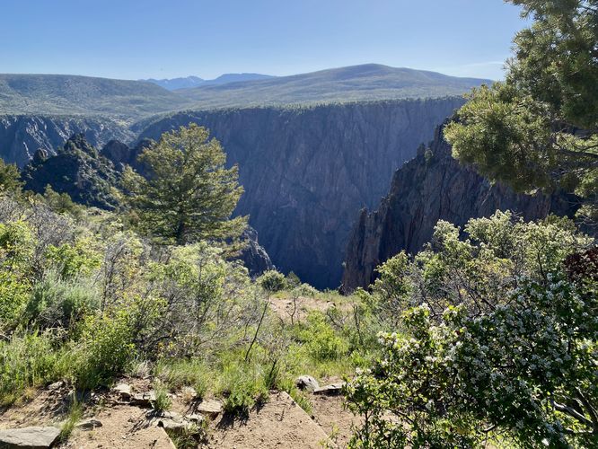
The Rim Rock Trail, starting in the south, leads out from the campground located approximately 0.1-miles south of this trailhead. Hikers will soon be lead into an open expanse of views into the Black Canyon not long after starting this hike from the south. The trail leads downhill and leads to eastward viewpoints around mile 0.1. From here, you'll find a plethora of views along the Rim Rock Trail as it meanders its way along the rim, heading north. For the most part, the trail is easy to follow with rocks and tree roots that pose the biggest threat to safety. The trail has undulation and a descent at the start or an ascent if hiking north to south, located closer to the campground.
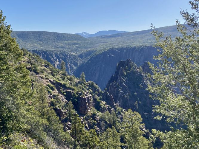
Southeast Views - Mile 0.3
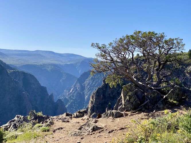
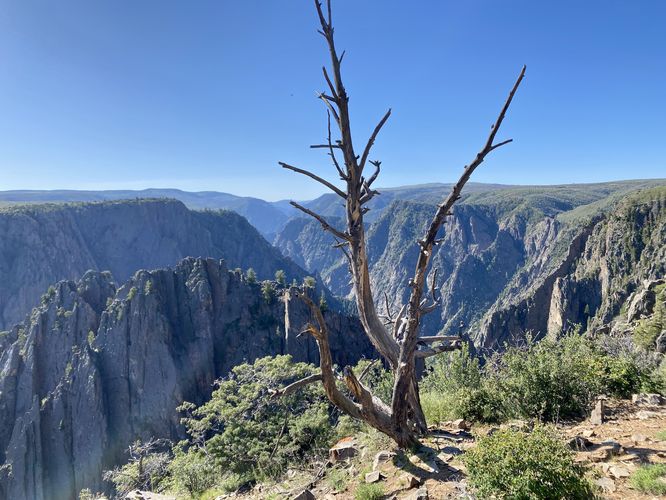
Around mile 0.3, hikers will reach a rocky outcropping with views that face southeast into the canyon. Here you'll find a very-old juniper tree clinging to a large boulder, which adds to the scenery. This is the first time, starting from the south, that hikers will get any southerly-facing views into the canyon. The views only get better as you hike toward Tomichi Point.
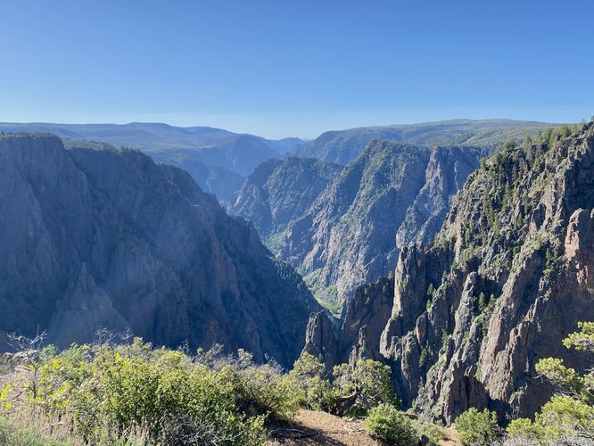
Tomichi Point / Views - Mile 0.5
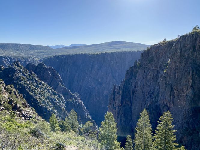
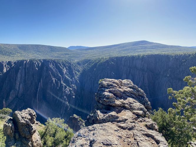
At mile 0.5, hikers will reach the overlook called Tomichi Point. From Tomichi Point, you'll find south-facing views directly into the Black Canyon with the Gunnison River roaring through the bottom of the gorge. The views from here are unmatched along this part of the south rim, so take them in while you're there. The views still aren't over though and you'll find plenty more as you make your way to the northern trailhead.
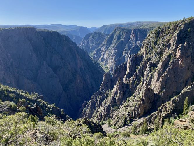
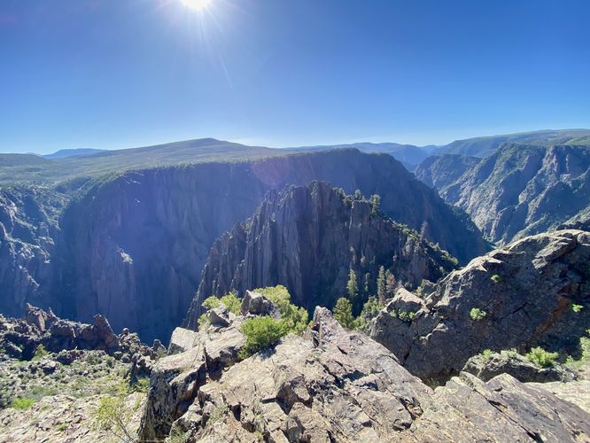
Rock Spire Views - Mile 0.6
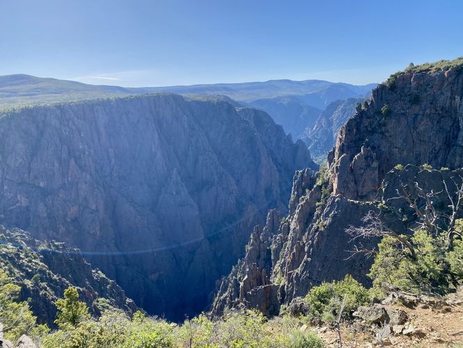
Around mile 0.6, hikers will find southward views that include rock "spires", technically canyon ridges, that jut into the Black Canyon and create somewhat of a rock "island" view that sits in the middle of the canyon. These canyon ridges are not surrounded by water almost appear that way. The views here make for unique scenery along the canyon's rim.
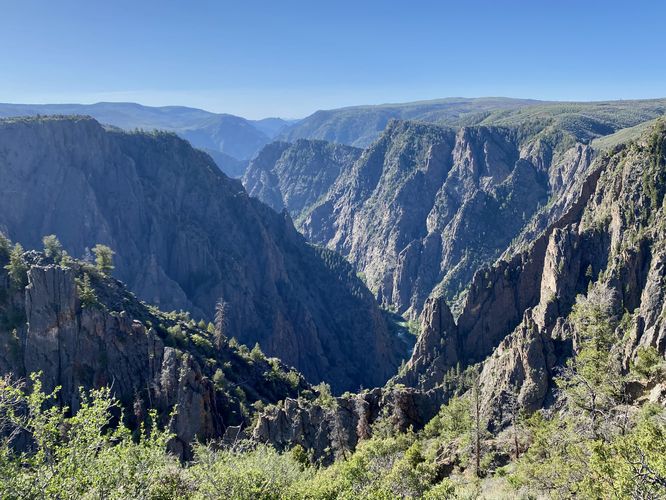
Eastward Views / Jutting Rock - Mile 0.75
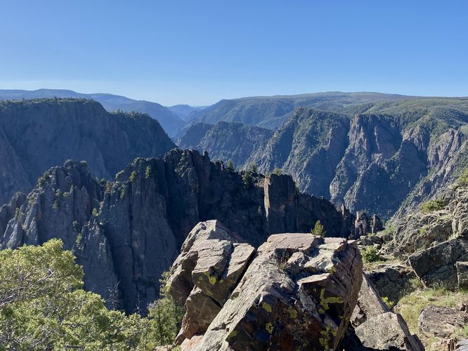
Around mile 0.75, the last of the rock outcropping with views can be found on-trail. There's a large section of bedrock that juts out perpendicular from the trail and leads hikers to a stunning view above the canyon. Just watch your step as this jutting rock has very steep and tall cliffs alongside. The views here are mostly eastward-facing, but you'll find some southern views here that also include the canyon ridge "rock spires" that you just passed.
Visitors Center - Mile 0.9
Finally, the trail ends at the visitors center parking lot to complete this 0.9-mile one-way hike. Remember that you can always hike this in a loop with the other trails nearby. For more details, read the Other Hikes section below.
Other Hikes
While checking out this trail, you might want to consider hiking other trails nearby like the Flat Oak Loop Trail, Uplands Trail, or the Gunnison Point Trail -- all of which connect close to this trail or are accessible from the same parking lot.
Pets
Dogs are allowed on this trail only if leashed and cleaned up after. Note that dogs are only allowed in parking lots, campgrounds, on paths to overlook, the Rim Rock Trail, and the Chasm View Nature Trail. Dogs are not permitted on any other trails in the park. You can read all of the rules and regulations for pets at the park here.
Parking
Hikers will find a large parking lot at the visitors center. The lot is large enough to fit a few dozen vehicles as of June 2024.
Warnings
Steep cliffs: Despite the abundance of safety precautions (i.e. fencing), this trail leads to cliffs that might drop 2,000-feet or more into the Black Canyon. Be aware of your surroundings.
Sun exposure: This trail has very-little shade and also sits at about 8,000-feet above sea level which increases the UV index. It's smart to wear sunscreen and bring extra sun protection when hiking this trail and other trails at Black Canyon of the Gunnison National Park.
Elevation sickness: This trail brings hikers through an altitude of about 8,000-feet above sea level. Around the 7,000-foot mark above sea level, you may start to experience symptoms of elevation sickness including shortness of breath, headaches, muscle aches, dizziness, rapid heartbeat, fatigue, or vomiting if you are not fully acclimated. If you're experiencing bad altitude sickness symptoms, the smartest move is to get to lower elevation as soon as possible.
Hike
This hike begins at the southern terminus for the Uplands Trail; however, many hikers will start this trail at the main trailhead, located at the visitors center to the north. During our visit here in early June 2024, we hiked the trails north of the visitors center before hopping on the Uplands Trail to reach the Rim Rock Trail for a longer loop hike -- you might want to consider doing something similar if you want to explore most of the day hikes at Black Canyon without registering for a backcountry permit (i.e. restricted trails).
The Rim Rock Trail, starting in the south, leads out from the campground located approximately 0.1-miles south of this trailhead. Hikers will soon be lead into an open expanse of views into the Black Canyon not long after starting this hike from the south. The trail leads downhill and leads to eastward viewpoints around mile 0.1. From here, you'll find a plethora of views along the Rim Rock Trail as it meanders its way along the rim, heading north. For the most part, the trail is easy to follow with rocks and tree roots that pose the biggest threat to safety. The trail has undulation and a descent at the start or an ascent if hiking north to south, located closer to the campground.
Southeast Views - Mile 0.3
Around mile 0.3, hikers will reach a rocky outcropping with views that face southeast into the canyon. Here you'll find a very-old juniper tree clinging to a large boulder, which adds to the scenery. This is the first time, starting from the south, that hikers will get any southerly-facing views into the canyon. The views only get better as you hike toward Tomichi Point.
Tomichi Point / Views - Mile 0.5
At mile 0.5, hikers will reach the overlook called Tomichi Point. From Tomichi Point, you'll find south-facing views directly into the Black Canyon with the Gunnison River roaring through the bottom of the gorge. The views from here are unmatched along this part of the south rim, so take them in while you're there. The views still aren't over though and you'll find plenty more as you make your way to the northern trailhead.
Rock Spire Views - Mile 0.6
Around mile 0.6, hikers will find southward views that include rock "spires", technically canyon ridges, that jut into the Black Canyon and create somewhat of a rock "island" view that sits in the middle of the canyon. These canyon ridges are not surrounded by water almost appear that way. The views here make for unique scenery along the canyon's rim.
Eastward Views / Jutting Rock - Mile 0.75
Around mile 0.75, the last of the rock outcropping with views can be found on-trail. There's a large section of bedrock that juts out perpendicular from the trail and leads hikers to a stunning view above the canyon. Just watch your step as this jutting rock has very steep and tall cliffs alongside. The views here are mostly eastward-facing, but you'll find some southern views here that also include the canyon ridge "rock spires" that you just passed.
Visitors Center - Mile 0.9
Finally, the trail ends at the visitors center parking lot to complete this 0.9-mile one-way hike. Remember that you can always hike this in a loop with the other trails nearby. For more details, read the Other Hikes section below.
Other Hikes
While checking out this trail, you might want to consider hiking other trails nearby like the Flat Oak Loop Trail, Uplands Trail, or the Gunnison Point Trail -- all of which connect close to this trail or are accessible from the same parking lot.
Pets
Dogs are allowed on this trail only if leashed and cleaned up after. Note that dogs are only allowed in parking lots, campgrounds, on paths to overlook, the Rim Rock Trail, and the Chasm View Nature Trail. Dogs are not permitted on any other trails in the park. You can read all of the rules and regulations for pets at the park here.
Parking
Hikers will find a large parking lot at the visitors center. The lot is large enough to fit a few dozen vehicles as of June 2024.
Warnings
Steep cliffs: Despite the abundance of safety precautions (i.e. fencing), this trail leads to cliffs that might drop 2,000-feet or more into the Black Canyon. Be aware of your surroundings.
Sun exposure: This trail has very-little shade and also sits at about 8,000-feet above sea level which increases the UV index. It's smart to wear sunscreen and bring extra sun protection when hiking this trail and other trails at Black Canyon of the Gunnison National Park.
Elevation sickness: This trail brings hikers through an altitude of about 8,000-feet above sea level. Around the 7,000-foot mark above sea level, you may start to experience symptoms of elevation sickness including shortness of breath, headaches, muscle aches, dizziness, rapid heartbeat, fatigue, or vomiting if you are not fully acclimated. If you're experiencing bad altitude sickness symptoms, the smartest move is to get to lower elevation as soon as possible.