The Cross Fissures View Trail at Black Canyon of the Gunnison National Park
near Montrose, Colorado is an easy 0.3-mile out-and-back hike that
features views of the jagged cliff landscape within the Black Canyon.
Hike
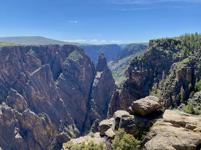
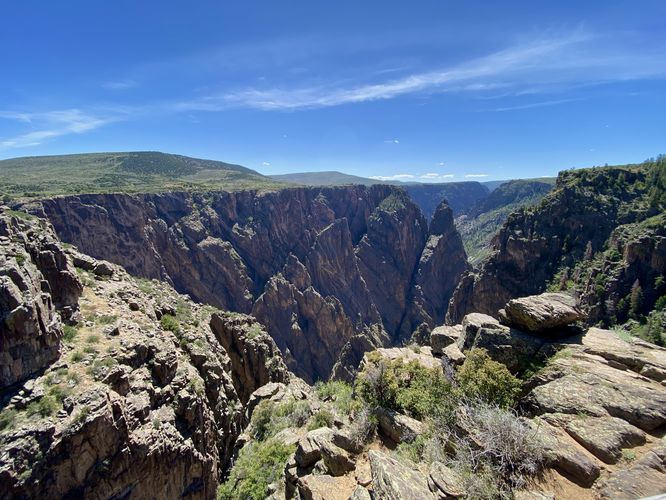
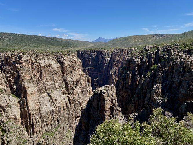
This trail begins at the main trailhead for Cross Fissures View heads downhill along a dirt trail to reach an eastward view of the Black Canyon. From this view, visitors will find jagged cliffs that jut up within the canyon with the Gunnison River roaring ~2,000-feet below. After exploring the eastern viewpoint, hikers can follow the trail as it leads west to yet another view of the Black Canyon with a different perspective. The second overlook is located around mile 0.2 and features views of the jagged rocks that jut out of the canyon along with the West Elk Mountains in the background, which sit above the canyon's north rim. Once done exploring both views, the short loop trail connects back to the main pathway to complete this 0.3-mile out-and-back (lollipop) hike to the Cross Fissures View.
Other South Rim Trails
Black Canyon Gunnison National Park's south rim is by far the most popular section of the park for visitors to explore. For popular day hikes, consider checking out Gunnison Point for stunning canyon views or hike the adjacent Oak Flat Loop Trail that descends into the gorge. You can then hike the Uplands Trail to reach the Rim Rock Trail which runs along the south rim and provides stunning views of the canyon along the way. To the west, at the end of the park's road, lies the Warner Point Trail which provides hikers with another moderate hike to a overlook that sits above the deepest section of Black Canyon. The rest of the trails along the south rim are very short hikes or simply peaceful nature walks that lead to views. Plan your trip to the Black Canyon by checking out our guides to each of the short overlooks along the south rim - starting from west to east: Sunset View, Dragon Point, Cedar Point, Painted Wall View, Chasm View, Devil's Overlook, Rock Point, Cross Fissures View, and Pulpit Rock.
Pets
Dogs are allowed on this trail only if leashed and must be cleaned up after. Note that dogs are only allowed in parking lots, campgrounds, on paths to overlooks (like this one), the Rim Rock Trail, and the Chasm View Nature Trail. Dogs are not permitted on any other trails in the park. You can read all of the rules and regulations for pets at the park here.
Parking
Hikers will find a parking turnout at the coordinates provided, located along South Rim Road in the park. The lot is large enough to fit less than a dozen vehicles as of June 2024.
Warnings
Steep cliffs: Despite the abundance of safety precautions (i.e. fencing), this trail leads to cliffs that might drop 2,000-feet or more into the Black Canyon. Be aware of your surroundings.
Sun exposure: This trail has very-little shade and also sits at about 8,000-feet above sea level which increases the UV index. It's smart to wear sunscreen and bring extra sun protection when hiking this trail and other trails at Black Canyon of the Gunnison National Park.
Elevation sickness: This trail brings hikers through an altitude of about 8,000-feet above sea level. Around the 7,000-foot mark above sea level, you may start to experience symptoms of elevation sickness including shortness of breath, headaches, muscle aches, dizziness, rapid heartbeat, fatigue, or vomiting if you are not fully acclimated. If you're experiencing bad altitude sickness symptoms, the smartest move is to get to lower elevation as soon as possible.
Hike
This trail begins at the main trailhead for Cross Fissures View heads downhill along a dirt trail to reach an eastward view of the Black Canyon. From this view, visitors will find jagged cliffs that jut up within the canyon with the Gunnison River roaring ~2,000-feet below. After exploring the eastern viewpoint, hikers can follow the trail as it leads west to yet another view of the Black Canyon with a different perspective. The second overlook is located around mile 0.2 and features views of the jagged rocks that jut out of the canyon along with the West Elk Mountains in the background, which sit above the canyon's north rim. Once done exploring both views, the short loop trail connects back to the main pathway to complete this 0.3-mile out-and-back (lollipop) hike to the Cross Fissures View.
Other South Rim Trails
Black Canyon Gunnison National Park's south rim is by far the most popular section of the park for visitors to explore. For popular day hikes, consider checking out Gunnison Point for stunning canyon views or hike the adjacent Oak Flat Loop Trail that descends into the gorge. You can then hike the Uplands Trail to reach the Rim Rock Trail which runs along the south rim and provides stunning views of the canyon along the way. To the west, at the end of the park's road, lies the Warner Point Trail which provides hikers with another moderate hike to a overlook that sits above the deepest section of Black Canyon. The rest of the trails along the south rim are very short hikes or simply peaceful nature walks that lead to views. Plan your trip to the Black Canyon by checking out our guides to each of the short overlooks along the south rim - starting from west to east: Sunset View, Dragon Point, Cedar Point, Painted Wall View, Chasm View, Devil's Overlook, Rock Point, Cross Fissures View, and Pulpit Rock.
Pets
Dogs are allowed on this trail only if leashed and must be cleaned up after. Note that dogs are only allowed in parking lots, campgrounds, on paths to overlooks (like this one), the Rim Rock Trail, and the Chasm View Nature Trail. Dogs are not permitted on any other trails in the park. You can read all of the rules and regulations for pets at the park here.
Parking
Hikers will find a parking turnout at the coordinates provided, located along South Rim Road in the park. The lot is large enough to fit less than a dozen vehicles as of June 2024.
Warnings
Steep cliffs: Despite the abundance of safety precautions (i.e. fencing), this trail leads to cliffs that might drop 2,000-feet or more into the Black Canyon. Be aware of your surroundings.
Sun exposure: This trail has very-little shade and also sits at about 8,000-feet above sea level which increases the UV index. It's smart to wear sunscreen and bring extra sun protection when hiking this trail and other trails at Black Canyon of the Gunnison National Park.
Elevation sickness: This trail brings hikers through an altitude of about 8,000-feet above sea level. Around the 7,000-foot mark above sea level, you may start to experience symptoms of elevation sickness including shortness of breath, headaches, muscle aches, dizziness, rapid heartbeat, fatigue, or vomiting if you are not fully acclimated. If you're experiencing bad altitude sickness symptoms, the smartest move is to get to lower elevation as soon as possible.