The Warner Point Trail at Black Canyon of the Gunnison National Park near Montrose, Colorado is a moderate 1.6-mile out-and-back hike that leads to the western-most lookout point of the Black Canyon and features breathtaking views.
Hike
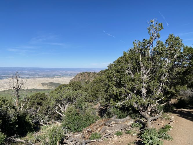
This hike begins at the main trailhead for the Warner Point Trail, located on the western end of South Rim Road at the park. The trail has interpretive signs where you can choose pay $1 for a self-guided interpretive booklet at the trailhead that describes different plants and sights along the trail. The Warner Point Trail begins by heading downhill right off the bat as it runs along an undulating ridge on the south side of the Black Canyon, passing through a beautiful pinyon pine / juniper forest. The trail undulates quite a bit as it makes its way out toward Warner Point -- keep in mind, you'll hike the same undulating hills on the way back to parking later.
South-Facing Views - Mile 0.06 to 0.16
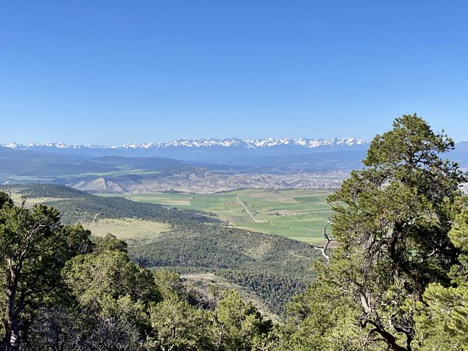
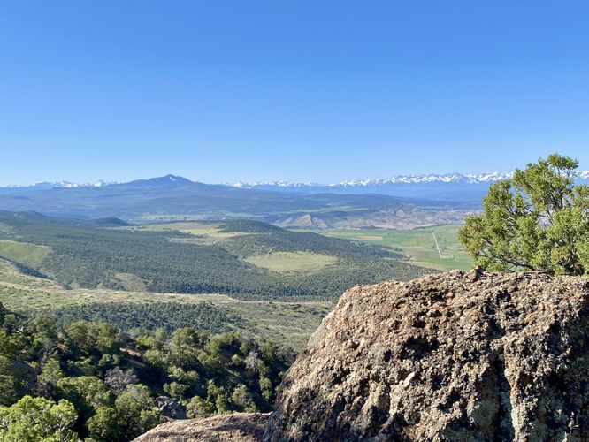
Along the way are views scattered throughout the trail, but from early-on along the trail you'll find several lookout points of the snow-capped mountains down near Ouray, Colorado. These south-facing views can be found near the start of the trail until mile 0.16 or so.
Canyon and South Views - Mile 0.2 to 0.3
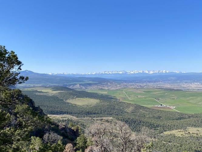
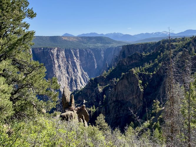
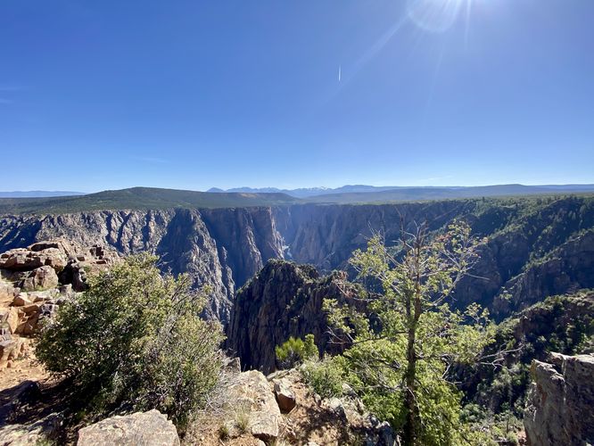
At mile 0.2, hikers will reach the bottom of the first ridge hill where you'll find a nice view of the Black Canyon, facing northeast with a backdrop of the West Elk Mountains. Just beyond, around mile 0.3, located just up the next steep (but short) hill is another similar view of the Black Canyon with an adjacent south-facing view of the mountains down near Ouray, Colorado.
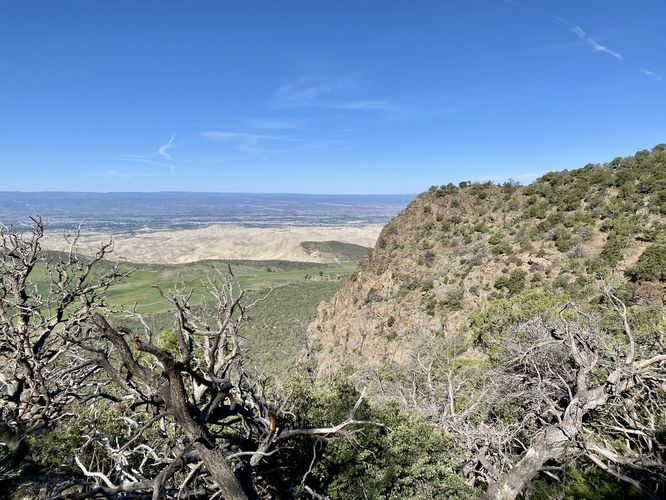
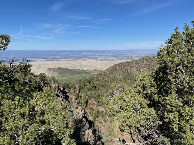
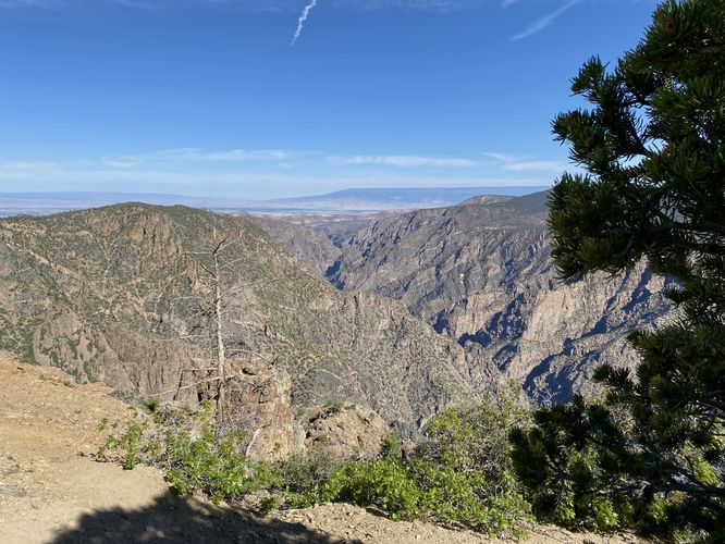
Hikers will reach the top of the first hill around mile 0.4. Shortly after, it drops once more before climbing back up a second hill. Along the way, the trail passes through a forest of low-growing shrubs and ancient juniper trees -- some of which are approximately 800-years old. Throughout this part of the hike, you may find some views between the trees, but the landscape is more broad toward the canyon's rim, so the views are less than spectacular here. Hikers will then climb the second hill to reach the top, around mile 0.7. The trail then dips back down toward Warner Point -- along the way is a stunning westward view of the Black Canyon as it makes its journey toward Delta, Colorado.
Warner Point - Mile 0.8
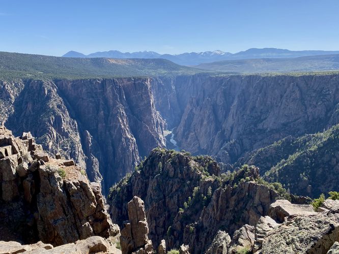
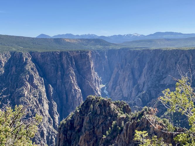
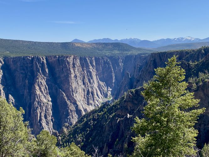
Hikers will finally reach the breathtaking Warner Point around mile 0.8. Warner Point boasts one of the best views of the Gunnison River as it cuts its way through the Black Canyon. This section of the Black Canyon is one of the deepest at approximately 2,600-feet deep (give or take 100-feet). Surrounding Warner Point are a plethora of cliffs, overlooks, and views, so watch your step as you explore this part of the trail. Behind the Black Canyon are the West Elk Mountains - often snow-capped - that provide additional scenery to this already-stunning landscape.
After exploring Warner Point, the hike back follows the same path you hiked-in on. Remember that the hills are fairly steep with over 150-feet of elevation change on the tallest one. The undulating path and excessive high-altitude heat, with low shade, makes for somewhat of a challenging hike so remember to stay hydrated on the hike out. You'll reach the parking lot to complete this hike for approximately 1.6 miles.
Pets
Dogs are not allowed on this trail. Note that dogs are only allowed in parking lots, campgrounds, on paths to overlook, the Rim Rock Trail, and the Chasm View Nature Trail. Dogs are not permitted on any other trails in the park. You can read all of the rules and regulations for pets at the park here.
Parking
Hikers will find a large parking lot at the coordinates provided, located at the very end of South Rim Road in the park. The lot is large enough to fit a few dozen vehicles as of June 2024.
Warnings
Steep cliffs: Despite the abundance of safety precautions (i.e. fencing), this trail leads to cliffs that might drop 2,000-feet or more into the Black Canyon. Be aware of your surroundings.
Sun exposure: This trail has very-little shade and also sits at about 8,000-feet above sea level which increases the UV index. It's smart to wear sunscreen and bring extra sun protection when hiking this trail and other trails at Black Canyon of the Gunnison National Park.
Elevation sickness: This trail brings hikers through an altitude of about 8,000-feet above sea level. Around the 7,000-foot mark above sea level, you may start to experience symptoms of elevation sickness including shortness of breath, headaches, muscle aches, dizziness, rapid heartbeat, fatigue, or vomiting if you are not fully acclimated. If you're experiencing bad altitude sickness symptoms, the smartest move is to get to lower elevation as soon as possible.
Hike
This hike begins at the main trailhead for the Warner Point Trail, located on the western end of South Rim Road at the park. The trail has interpretive signs where you can choose pay $1 for a self-guided interpretive booklet at the trailhead that describes different plants and sights along the trail. The Warner Point Trail begins by heading downhill right off the bat as it runs along an undulating ridge on the south side of the Black Canyon, passing through a beautiful pinyon pine / juniper forest. The trail undulates quite a bit as it makes its way out toward Warner Point -- keep in mind, you'll hike the same undulating hills on the way back to parking later.
South-Facing Views - Mile 0.06 to 0.16
Along the way are views scattered throughout the trail, but from early-on along the trail you'll find several lookout points of the snow-capped mountains down near Ouray, Colorado. These south-facing views can be found near the start of the trail until mile 0.16 or so.
Canyon and South Views - Mile 0.2 to 0.3
At mile 0.2, hikers will reach the bottom of the first ridge hill where you'll find a nice view of the Black Canyon, facing northeast with a backdrop of the West Elk Mountains. Just beyond, around mile 0.3, located just up the next steep (but short) hill is another similar view of the Black Canyon with an adjacent south-facing view of the mountains down near Ouray, Colorado.
Hikers will reach the top of the first hill around mile 0.4. Shortly after, it drops once more before climbing back up a second hill. Along the way, the trail passes through a forest of low-growing shrubs and ancient juniper trees -- some of which are approximately 800-years old. Throughout this part of the hike, you may find some views between the trees, but the landscape is more broad toward the canyon's rim, so the views are less than spectacular here. Hikers will then climb the second hill to reach the top, around mile 0.7. The trail then dips back down toward Warner Point -- along the way is a stunning westward view of the Black Canyon as it makes its journey toward Delta, Colorado.
Warner Point - Mile 0.8
Hikers will finally reach the breathtaking Warner Point around mile 0.8. Warner Point boasts one of the best views of the Gunnison River as it cuts its way through the Black Canyon. This section of the Black Canyon is one of the deepest at approximately 2,600-feet deep (give or take 100-feet). Surrounding Warner Point are a plethora of cliffs, overlooks, and views, so watch your step as you explore this part of the trail. Behind the Black Canyon are the West Elk Mountains - often snow-capped - that provide additional scenery to this already-stunning landscape.
After exploring Warner Point, the hike back follows the same path you hiked-in on. Remember that the hills are fairly steep with over 150-feet of elevation change on the tallest one. The undulating path and excessive high-altitude heat, with low shade, makes for somewhat of a challenging hike so remember to stay hydrated on the hike out. You'll reach the parking lot to complete this hike for approximately 1.6 miles.
Pets
Dogs are not allowed on this trail. Note that dogs are only allowed in parking lots, campgrounds, on paths to overlook, the Rim Rock Trail, and the Chasm View Nature Trail. Dogs are not permitted on any other trails in the park. You can read all of the rules and regulations for pets at the park here.
Parking
Hikers will find a large parking lot at the coordinates provided, located at the very end of South Rim Road in the park. The lot is large enough to fit a few dozen vehicles as of June 2024.
Warnings
Steep cliffs: Despite the abundance of safety precautions (i.e. fencing), this trail leads to cliffs that might drop 2,000-feet or more into the Black Canyon. Be aware of your surroundings.
Sun exposure: This trail has very-little shade and also sits at about 8,000-feet above sea level which increases the UV index. It's smart to wear sunscreen and bring extra sun protection when hiking this trail and other trails at Black Canyon of the Gunnison National Park.
Elevation sickness: This trail brings hikers through an altitude of about 8,000-feet above sea level. Around the 7,000-foot mark above sea level, you may start to experience symptoms of elevation sickness including shortness of breath, headaches, muscle aches, dizziness, rapid heartbeat, fatigue, or vomiting if you are not fully acclimated. If you're experiencing bad altitude sickness symptoms, the smartest move is to get to lower elevation as soon as possible.