The Chasm View Nature Trail at Black Canyon of the Gunnison National Park
near Crawford, Colorado is an easy 0.6-mile loop hike that features some of the best views of the Black Canyon from its north rim including views of the Painted Wall.
Hike
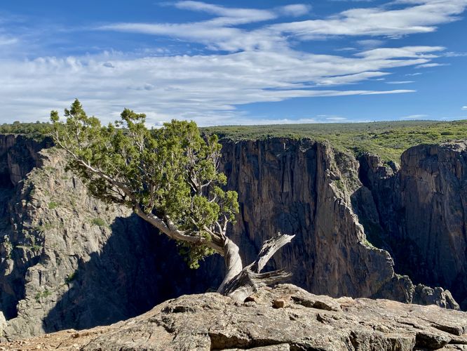
This hike begins at the main trailhead for the Chasm View Nature Trail at the very end of Black Canyon Road on the north rim of the canyon. This route follows the loop in a counter-clockwise direction, leading hikers along the northwest side of the loop first. Hikers can choose to buy a $1 interpretive self-guided pamphlet at the trailhead to learn about the many different natural sights that the trail has to offer along the way -- many of the interpretive signs are about the old-growth juniper trees and other natural formations.
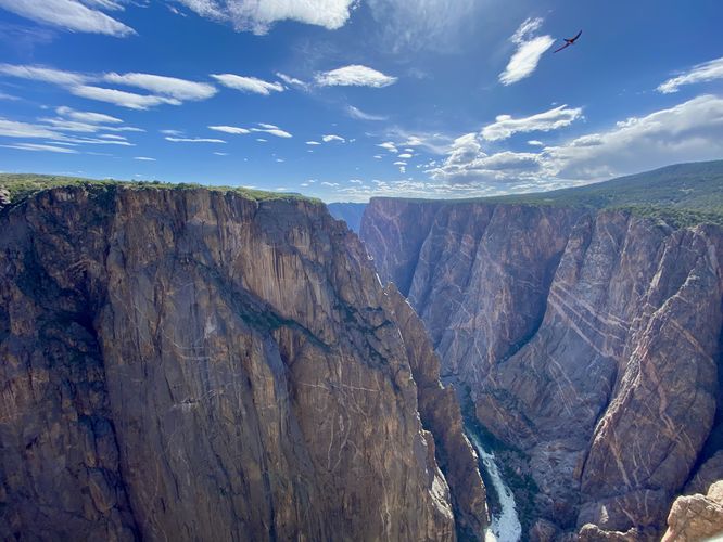
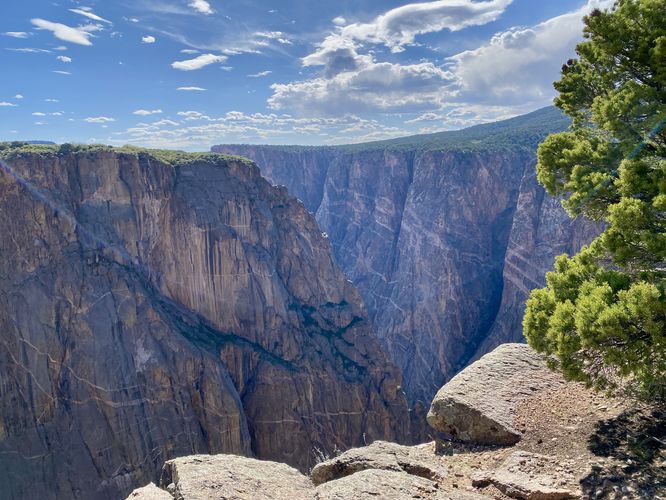
Painted Wall View - Mile 0.16
Around mile 0.16, hikers will reach the first overlook along the trail. This overlook is fairly large with fencing that adorns the edges, helping prevent a 2,000-foot fall into the canyon below. From this overlook you'll find breathtaking views of the Gunnison River as its mends its way around the 2,250-foot tall Painted Wall (Colorado's tallest sheer cliff). The views don't end here, so continuing south along the trail provides different perspectives of the Black Canyon.
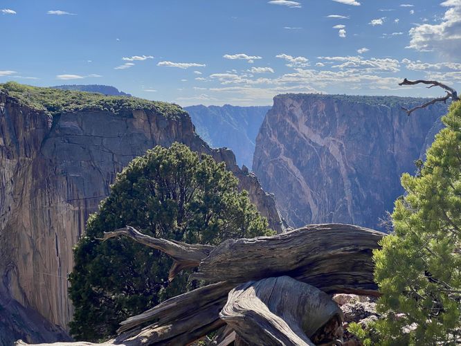
Views - Mile 0.2 to 0.3
After exploring the first main overlook at the Painted Wall, hikers will head south to find several more views into the Black Canyon -- mostly between miles 0.2 and 0.3. These views are mostly that of the jutting cliff outcroppings within the canyon and more views toward the Painted Wall.
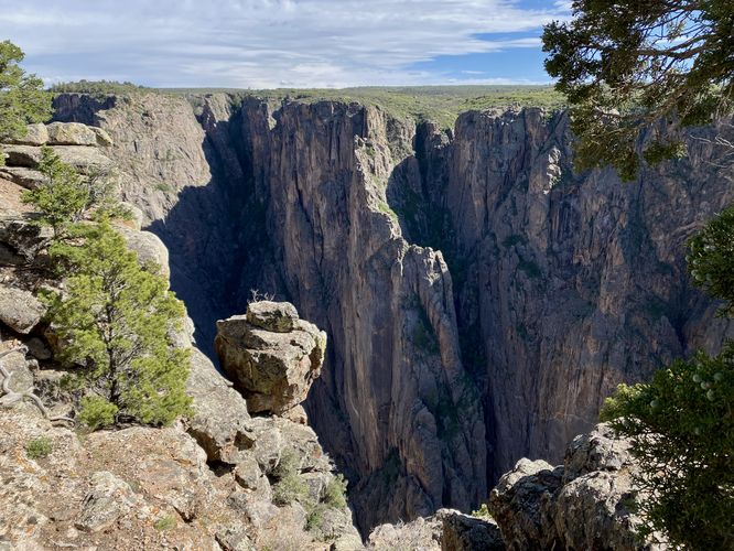
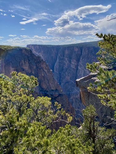
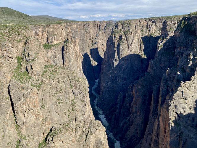
The Narrows View - Mile 0.35
The last view along the trail sits around mile 0.35. Here, hikers will find southeast views into the canyon's steep cliff area known as The Narrows. If you explored the other The Narrows View Trail earlier, here, you can peer into the gorge with a much-better view of the Gunnison River as it cuts its way through these insanely-steep and tall cliffs.
After exploring the view of The Narrows, hikers will follow the Chasm View Nature Trail back up to parking to complete the loop for ~0.6-miles.
Seclusion on the North Rim
Black Canyon Gunnison National Park's north rim is visited by far less people and provides abundant seclusion for those who want to get away from the crowds. For popular day hikes on the north rim, consider checking out the Chasm View Nature Trail in addition to other trails like the North Vista Trail and the Deadhorse Trail. The rest of the quick-hit trails along the north rim are very short walks or short paths that lead to canyon overlooks. Plan your trip to the Black Canyon by checking out our guides to each of the short overlooks along the north rim - starting from west to east: The Narrows View, Balanced Rock View, Big Island View, Island Peaks View, and the Kneeling Camel View.
Pets
Dogs are allowed on this trail only if leashed and must be cleaned up after. Note that dogs are only allowed in parking lots, campgrounds, on paths to overlooks (like this one), the Rim Rock Trail, and the Chasm View Nature Trail. Dogs are not permitted on any other trails in the park. You can read all of the rules and regulations for pets at the park here.
Parking
Hikers will find a parking turnout at the coordinates provided, located at the very end of Black Canyon Road in the park. The lot is large enough to fit less than a dozen vehicles as of June 2024.
Warnings
Steep cliffs: Despite the abundance of safety precautions (i.e. fencing), this trail leads to cliffs that might drop 2,000-feet or more into the Black Canyon. Be aware of your surroundings.
Sun exposure: This trail has very-little shade and also sits at about 7,700-feet above sea level which increases the UV index. It's smart to wear sunscreen and bring extra sun protection when hiking this trail and other trails at Black Canyon of the Gunnison National Park.
Elevation sickness: This trail brings hikers through an altitude of about 7,700-feet above sea level. Around the 7,000-foot mark above sea level, you may start to experience symptoms of elevation sickness including shortness of breath, headaches, muscle aches, dizziness, rapid heartbeat, fatigue, or vomiting if you are not fully acclimated. If you're experiencing bad altitude sickness symptoms, the smartest move is to get to lower elevation as soon as possible.
Hike
This hike begins at the main trailhead for the Chasm View Nature Trail at the very end of Black Canyon Road on the north rim of the canyon. This route follows the loop in a counter-clockwise direction, leading hikers along the northwest side of the loop first. Hikers can choose to buy a $1 interpretive self-guided pamphlet at the trailhead to learn about the many different natural sights that the trail has to offer along the way -- many of the interpretive signs are about the old-growth juniper trees and other natural formations.
Painted Wall View - Mile 0.16
Around mile 0.16, hikers will reach the first overlook along the trail. This overlook is fairly large with fencing that adorns the edges, helping prevent a 2,000-foot fall into the canyon below. From this overlook you'll find breathtaking views of the Gunnison River as its mends its way around the 2,250-foot tall Painted Wall (Colorado's tallest sheer cliff). The views don't end here, so continuing south along the trail provides different perspectives of the Black Canyon.
Views - Mile 0.2 to 0.3
After exploring the first main overlook at the Painted Wall, hikers will head south to find several more views into the Black Canyon -- mostly between miles 0.2 and 0.3. These views are mostly that of the jutting cliff outcroppings within the canyon and more views toward the Painted Wall.
The Narrows View - Mile 0.35
The last view along the trail sits around mile 0.35. Here, hikers will find southeast views into the canyon's steep cliff area known as The Narrows. If you explored the other The Narrows View Trail earlier, here, you can peer into the gorge with a much-better view of the Gunnison River as it cuts its way through these insanely-steep and tall cliffs.
After exploring the view of The Narrows, hikers will follow the Chasm View Nature Trail back up to parking to complete the loop for ~0.6-miles.
Seclusion on the North Rim
Black Canyon Gunnison National Park's north rim is visited by far less people and provides abundant seclusion for those who want to get away from the crowds. For popular day hikes on the north rim, consider checking out the Chasm View Nature Trail in addition to other trails like the North Vista Trail and the Deadhorse Trail. The rest of the quick-hit trails along the north rim are very short walks or short paths that lead to canyon overlooks. Plan your trip to the Black Canyon by checking out our guides to each of the short overlooks along the north rim - starting from west to east: The Narrows View, Balanced Rock View, Big Island View, Island Peaks View, and the Kneeling Camel View.
Pets
Dogs are allowed on this trail only if leashed and must be cleaned up after. Note that dogs are only allowed in parking lots, campgrounds, on paths to overlooks (like this one), the Rim Rock Trail, and the Chasm View Nature Trail. Dogs are not permitted on any other trails in the park. You can read all of the rules and regulations for pets at the park here.
Parking
Hikers will find a parking turnout at the coordinates provided, located at the very end of Black Canyon Road in the park. The lot is large enough to fit less than a dozen vehicles as of June 2024.
Warnings
Steep cliffs: Despite the abundance of safety precautions (i.e. fencing), this trail leads to cliffs that might drop 2,000-feet or more into the Black Canyon. Be aware of your surroundings.
Sun exposure: This trail has very-little shade and also sits at about 7,700-feet above sea level which increases the UV index. It's smart to wear sunscreen and bring extra sun protection when hiking this trail and other trails at Black Canyon of the Gunnison National Park.
Elevation sickness: This trail brings hikers through an altitude of about 7,700-feet above sea level. Around the 7,000-foot mark above sea level, you may start to experience symptoms of elevation sickness including shortness of breath, headaches, muscle aches, dizziness, rapid heartbeat, fatigue, or vomiting if you are not fully acclimated. If you're experiencing bad altitude sickness symptoms, the smartest move is to get to lower elevation as soon as possible.