The Uplands Trail at Black Canyon of the Gunnison National Park
near Montrose, Colorado is an easy 0.9-mile one-way hike that connects the Flat Oak Loop Trail to the Rim Rock Trail and features views.
Hike
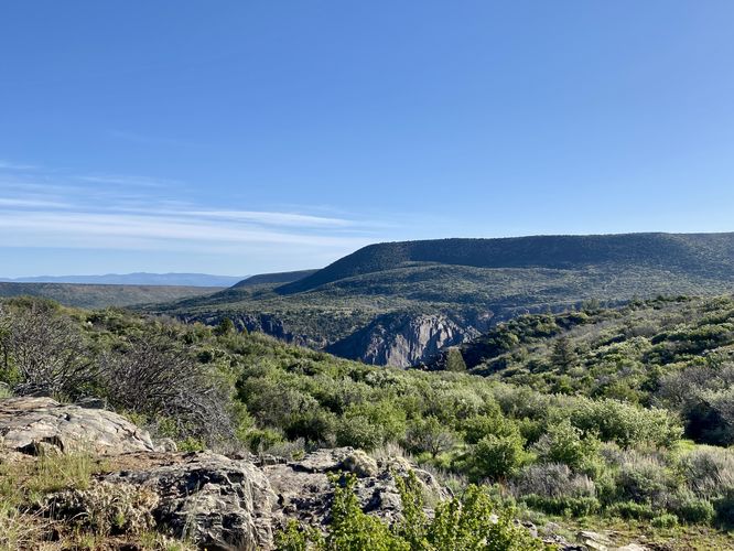
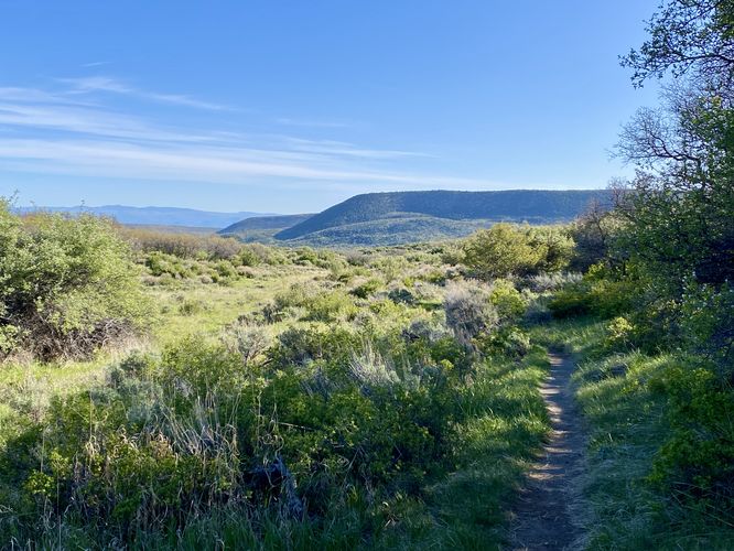
This hike begins at the trailhead for the Uplands Trail, located on the south side of the Flat Oak Loop Trail. Note that hikers can hop on this trail from either end as it also connects to the Rim Rock Trail -- creating a beautiful day hike loop to explore different views of the Black Canyon. The Uplands Trail follows a gradual uphill grade for most of the hike as the trail leads away from the southern rim of the Black Canyon, passing through open spaces with minimal shade. The trail provides only two "viewpoints" along the way -- one located around mile 0.15 and the other located at mile 0.6. Both of the views are found when hiking south and when the trail follows a switchback to head north for a very-short distance. If hiking this trail from south to north, the views are still there but you might find them at different a mileage depending on the turn in the trail and which direction you're facing.
Outside of the two viewpoints along the trail, hikers won't find much else to explore outside of a peaceful and quiet hike. This trail is one of the least-trafficked in the park for obvious reasons; however, it makes for a beautiful trail to hike all of the trails by the visitors center in a loop. Hikers will reach the Rim Rock Trail, if hiking south, at mile 0.9 at the end of the trail.
Mileage
The park map lists this trail at ~2-miles long; however, the mileage is only 0.9-miles one-way. This was a nice find after assuming the hike would be twice as long. Maybe the park's map has a typo or maybe they assumed folks would hike this as an out-and-back.
Other Hikes
While checking out this trail, you might want to consider hiking other trails nearby like the Flat Oak Loop Trail, Gunnison Point Trail, or the Rim Rock Trail -- all of which connect close to this trail or are accessible from the same parking lot.
Pets
Dogs are not allowed on this trail. Note that dogs are only allowed in parking lots, campgrounds, on paths to overlook, the Rim Rock Trail, and the Chasm View Nature Trail. Dogs are not permitted on any other trails in the park. You can read all of the rules and regulations for pets at the park here.
Parking
Hikers will find a large parking lot at the visitors center. The lot is large enough to fit a few dozen vehicles as of June 2024.
Warning
Sun exposure: This trail has very-little shade and also sits at about 8,000-feet above sea level which increases the UV index. It's smart to wear sunscreen and bring extra sun protection when hiking this trail and other trails at Black Canyon of the Gunnison National Park.
Hike
This hike begins at the trailhead for the Uplands Trail, located on the south side of the Flat Oak Loop Trail. Note that hikers can hop on this trail from either end as it also connects to the Rim Rock Trail -- creating a beautiful day hike loop to explore different views of the Black Canyon. The Uplands Trail follows a gradual uphill grade for most of the hike as the trail leads away from the southern rim of the Black Canyon, passing through open spaces with minimal shade. The trail provides only two "viewpoints" along the way -- one located around mile 0.15 and the other located at mile 0.6. Both of the views are found when hiking south and when the trail follows a switchback to head north for a very-short distance. If hiking this trail from south to north, the views are still there but you might find them at different a mileage depending on the turn in the trail and which direction you're facing.
Outside of the two viewpoints along the trail, hikers won't find much else to explore outside of a peaceful and quiet hike. This trail is one of the least-trafficked in the park for obvious reasons; however, it makes for a beautiful trail to hike all of the trails by the visitors center in a loop. Hikers will reach the Rim Rock Trail, if hiking south, at mile 0.9 at the end of the trail.
Mileage
The park map lists this trail at ~2-miles long; however, the mileage is only 0.9-miles one-way. This was a nice find after assuming the hike would be twice as long. Maybe the park's map has a typo or maybe they assumed folks would hike this as an out-and-back.
Other Hikes
While checking out this trail, you might want to consider hiking other trails nearby like the Flat Oak Loop Trail, Gunnison Point Trail, or the Rim Rock Trail -- all of which connect close to this trail or are accessible from the same parking lot.
Pets
Dogs are not allowed on this trail. Note that dogs are only allowed in parking lots, campgrounds, on paths to overlook, the Rim Rock Trail, and the Chasm View Nature Trail. Dogs are not permitted on any other trails in the park. You can read all of the rules and regulations for pets at the park here.
Parking
Hikers will find a large parking lot at the visitors center. The lot is large enough to fit a few dozen vehicles as of June 2024.
Warning
Sun exposure: This trail has very-little shade and also sits at about 8,000-feet above sea level which increases the UV index. It's smart to wear sunscreen and bring extra sun protection when hiking this trail and other trails at Black Canyon of the Gunnison National Park.