The Pinafore Run Trail to East Rim Vista at Tioga State Forest near Wellsboro, Pennsylvania is a difficult 5.7-mile out-and-back trek (with bushwhacking) that features a stunning little-known vista point along a mountain ridge of the PA Grand Canyon and also features a beautiful waterfall with footbridge, named Pinafore Ravine Falls.
Trails
This hike follows the Pine Creek Trail along with an approx. 160 year-old road that was once used for logging. There are no blazes and except for the small section of the Pine Creek Trail, this hike does not follow any maintained or blazed trails.
Warnings
Bushwhack: This hike requires bushwhacking and off-trail hiking along an unmaintained trail and old logging road. Do not attempt this hike if you do not have offline maps or are not an expert in topographic map reading.
Steep cliffs: Along the canyon's east rim, at the main vista point, and at the ravine of Pinafore Run are very steep cliffs and hillsides. Hikers should go slow and watch their step to avoid injuries.
No cell service: Without cell service, if you aren't careful, you might end up hurt in the woods for days.
Rattlesnakes: The Timber Rattlesnake calls these cliff areas and woods their home. While still more rare in this section of the canyon, they can still be found between April and October.
Hike Description
This hike includes bushwhacking, off-trail hiking, and requires the hiker to understand how to read topographical maps. Offline maps are recommended along with downloading our GPX file to ensure you find your way properly.
Darling Run Parking Area to Bushwhack
The hike begins at the Darling Run Parking Area for the Pine Creek Trail near Wellsboro, Pennsylvania. I (Admin) parked at the end of the service road, which is about 0.2-miles south of the main parking area, just to reduce the walking mileage. If you park in the main parking lot, the mileage written in this report will be slightly different.
Bushwhack to the 160 year-old Road
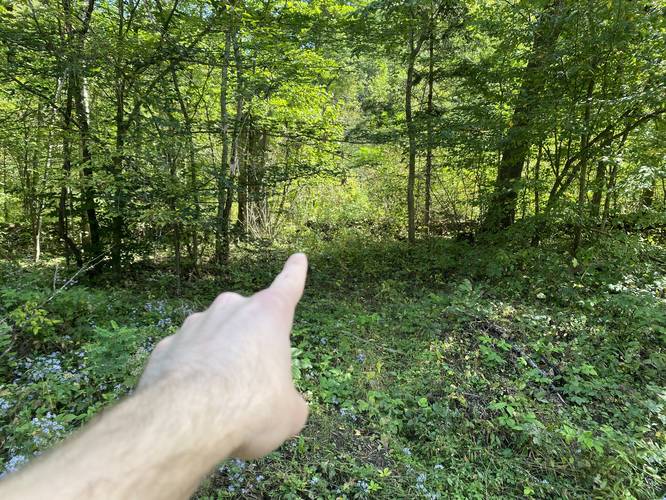
The hike heads down the Pine Creek Trail - passing Darling Run - and then cuts into the woods about 150-feet south of Darling Run creek, around mile 0.25. Hikers may find that animals have cut their own path through this brush; however, this is a small section of off-trail bushwhacking. While bushwhacking through this small section of woods, hike parallel to Darling Run and head toward the sloped hillside. At the sloped hillside, hikers should be able to find an old moderate grade that heads up the hill - this is the old public road that's no longer in use. This road was once used for logging and accessing the canyon via Pinafore Run, but today it's an unblazed, officially unmapped, and unmaintained trail that leads up and out of the canyon toward Pinafore Run creek.
Logging Road to Pinafore Run Creek
Once on the old road, the hike is fairly straight forward - just follow the trail uphill and eventually it'll flatten out. Some sections of the trail, especially closer to Pine Creek, are extremely steep - so watch your step. The hike, for about 1.6 miles, is easy to follow as you walk the old road; however, around mile 1.84, hikers will reach a fork in the trail. Here, you want to stay to the right-hand side to head toward Pinafore Run.
Finding the Footbridge and Pinafore Ravine Falls
Just 150-feet from the trail junction at mile 1.84, hikers will have to venture off-trail, heading due south, to reach the footbridge and Pinafore Ravine Falls. As of 2021 (and a decade earlier), the footbridge leads to nowhere as the other side is a dead-end because flooding has caused the hillside dirt to slide down to cover the old trail. Here, hikers may find that they cannot go any further if the water level is too high or if there's a lot of ice. If the water level is low enough, you can easily hike across Pinafore Run creek to reach the other side.
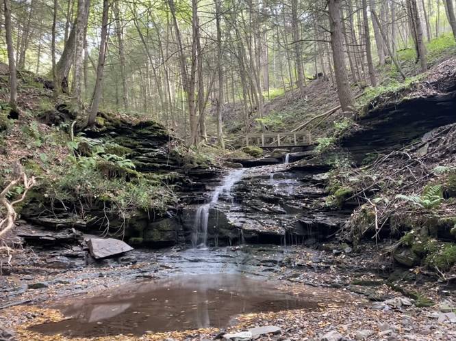
Pinafore Ravine Falls
At the footbridge, hikers will find several waterfalls which I've named Pinafore Ravine Falls (not be confused with Pinafore Falls, a 20-foot tall waterfall located downstream). The upper-most waterfall is about 5-feet tall, the middle falls is about 10-feet tall, and the two lower falls are about 5-feet tall with a 10+ foot gradual slope along red-colored rock. This area is stunning - it reminds me of the Ricketts Glen Falls Trail, except no one knows about this spot.
Bushwhack to East Canyon Rim
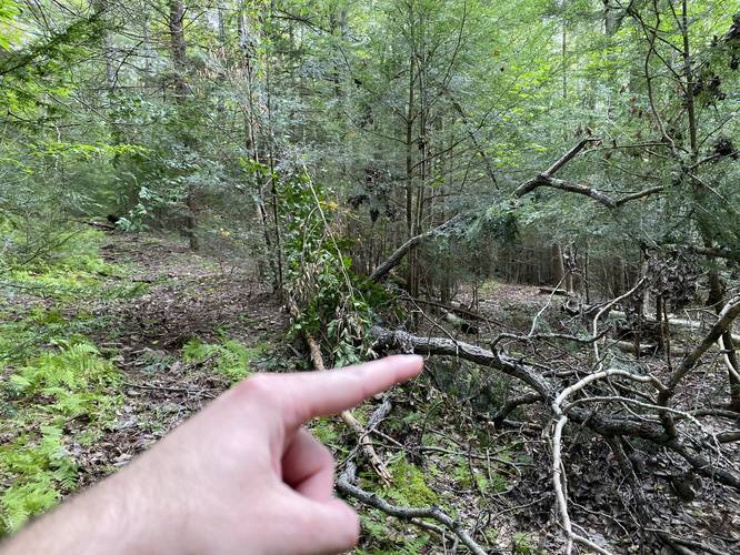
From Pinafore Ravine Falls, hikers will have to off-trail navigate along the continuation of the old logging road. It's difficult to see, but the old logging road technically follows the upper edge of the ravine - heading east from the waterfalls. The small section of trail between the waterfalls and approximately 0.1-miles onto the logging road is extremely dangerous as the ravine walls are over 40-feet high with a very steep slope and clearly flooding has changed the landscape over time, so watch your step. Just about 0.2-miles from the waterfalls is another flooding artifact where a stream has cut a 10-foot deep gouge into the land, making it so hikers have to go uphill and around this massive new ravine. Either way, once you make it past those two sketchy areas, the hike toward the canyon's east rim is fairly easy - just look for the light shining between the evergreens.
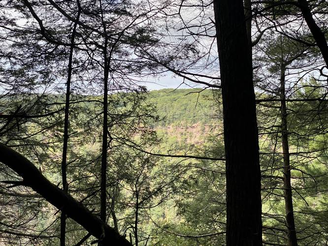
Hiking up the Canyon's East Rim
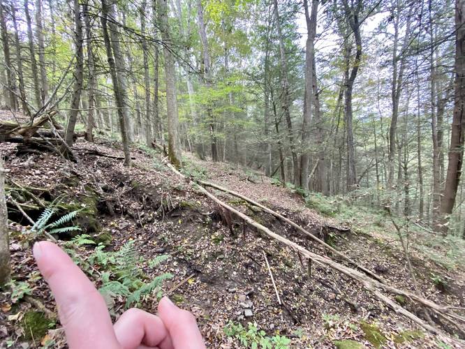
Once you make it to the canyon's east rim, the hike to each the East Rim Vista is straight forward, but a bit difficult and dangerous. The hike is mostly uphill, but you're hiking just a couple of feet away from a 100-foot drop-off cliff of the canyon's east rim. It helps that there are trees and space to walk further from the canyon rim, but it feels sketchy nonetheless. As you make your way up the east canyon rim, you'll likely scare a bald eagle or red-tailed hawk out of their nest as this section of forest is rarely visited by people.
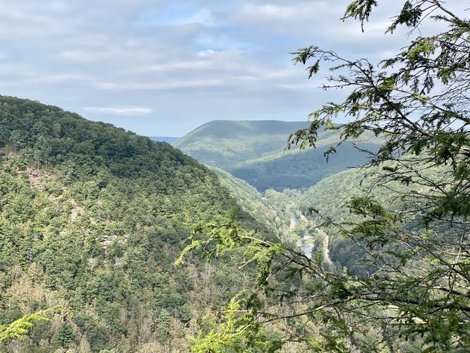
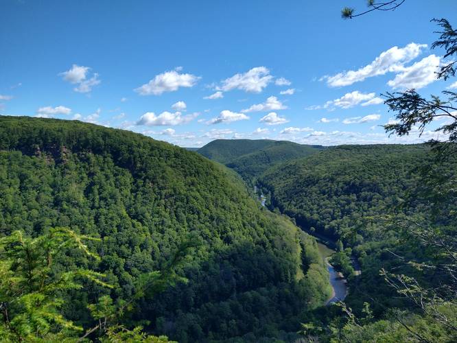
Reaching the East Rim Vista
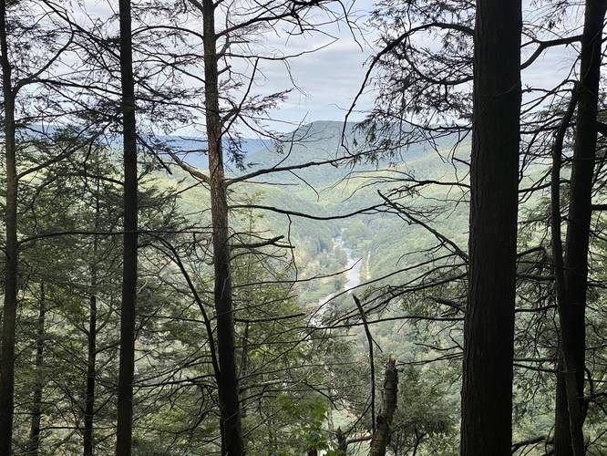
Finally, around mile 2.6, the trail will level out more and features a couple of obstructed views of Pine Creek, Mount Tom, the Pine Creek Trail, and Barbour Rock. These obstructed views are not the final destination; however, as the East Rim Vista is not far from here. Continue hiking the rim of the canyon to reach an open flat area covered with pine needles - the East Rim Vista is located at the back of this area, along a mountain ridge. The vista point is located along a mountain ridge with extremely steep drop-offs to each side, making this an extremely dangerous but a very neat location to hike to. The views from the vista include: Mount Tom, Barbour Rock, Pine Creek, the Pine Creek Trail, and an obstructed view toward Colton Point State Park.
Hiking Out
The hike out is obviously the reverse of the hike in; however, without a clear and defined trail, it makes it difficult to navigate your way out. The best recommendation is to track your hike in, so you can compare your current location on your way out to your previous data.
Pets
Dogs are allowed if leashed and their waste should be carried out by the hiker. Please note that beyond Pinafore Ravine Falls and the footbridge, the trail is not really suitable for dogs.
Backpacking and Camping
Backpackers will not find any campsites along this hike; however, the state forest does allow backpacking here. Leave no trace and please follow all state forest rules and regulations when primitive / dispersed / backcountry camping.
Difficulty
While none of the elevation grade is much more difficult than 'moderate', this hike is 'difficult' or 'hard' because of the off-trail navigation and terrain the hiker has to deal with.
History
All of this history is pulled from Chuck Dillon's book titled Short Hikes in Pennsylvania's Grand Canyon (2011). The Pinafore Run Trail, unofficially named, was acquired by the state in 1990, flagged, but never blazed It was meant to connect to Leonard Harrison State Park, but was never completed. The northern portion of this trail was once a public road about 160 years ago (circa 1860's) and was probably used to slide logs down to Pine Creek to then float them down to Williamsport.
Vista Point Name
I've named this vista the East Rim Vista as the PA Grand Canyon does not have very many overlooks and vistas along the East Rim except for at Leonard Harrison State Park. I also found one unofficial map labeling this as Kennedy Point; however, there's no further information or reason why, so both unofficial names can be used.
Trails
This hike follows the Pine Creek Trail along with an approx. 160 year-old road that was once used for logging. There are no blazes and except for the small section of the Pine Creek Trail, this hike does not follow any maintained or blazed trails.
Warnings
Bushwhack: This hike requires bushwhacking and off-trail hiking along an unmaintained trail and old logging road. Do not attempt this hike if you do not have offline maps or are not an expert in topographic map reading.
Steep cliffs: Along the canyon's east rim, at the main vista point, and at the ravine of Pinafore Run are very steep cliffs and hillsides. Hikers should go slow and watch their step to avoid injuries.
No cell service: Without cell service, if you aren't careful, you might end up hurt in the woods for days.
Rattlesnakes: The Timber Rattlesnake calls these cliff areas and woods their home. While still more rare in this section of the canyon, they can still be found between April and October.
Hike Description
This hike includes bushwhacking, off-trail hiking, and requires the hiker to understand how to read topographical maps. Offline maps are recommended along with downloading our GPX file to ensure you find your way properly.
Darling Run Parking Area to Bushwhack
The hike begins at the Darling Run Parking Area for the Pine Creek Trail near Wellsboro, Pennsylvania. I (Admin) parked at the end of the service road, which is about 0.2-miles south of the main parking area, just to reduce the walking mileage. If you park in the main parking lot, the mileage written in this report will be slightly different.
Bushwhack to the 160 year-old Road
The hike heads down the Pine Creek Trail - passing Darling Run - and then cuts into the woods about 150-feet south of Darling Run creek, around mile 0.25. Hikers may find that animals have cut their own path through this brush; however, this is a small section of off-trail bushwhacking. While bushwhacking through this small section of woods, hike parallel to Darling Run and head toward the sloped hillside. At the sloped hillside, hikers should be able to find an old moderate grade that heads up the hill - this is the old public road that's no longer in use. This road was once used for logging and accessing the canyon via Pinafore Run, but today it's an unblazed, officially unmapped, and unmaintained trail that leads up and out of the canyon toward Pinafore Run creek.
Logging Road to Pinafore Run Creek
Once on the old road, the hike is fairly straight forward - just follow the trail uphill and eventually it'll flatten out. Some sections of the trail, especially closer to Pine Creek, are extremely steep - so watch your step. The hike, for about 1.6 miles, is easy to follow as you walk the old road; however, around mile 1.84, hikers will reach a fork in the trail. Here, you want to stay to the right-hand side to head toward Pinafore Run.
Finding the Footbridge and Pinafore Ravine Falls
Just 150-feet from the trail junction at mile 1.84, hikers will have to venture off-trail, heading due south, to reach the footbridge and Pinafore Ravine Falls. As of 2021 (and a decade earlier), the footbridge leads to nowhere as the other side is a dead-end because flooding has caused the hillside dirt to slide down to cover the old trail. Here, hikers may find that they cannot go any further if the water level is too high or if there's a lot of ice. If the water level is low enough, you can easily hike across Pinafore Run creek to reach the other side.
Pinafore Ravine Falls
At the footbridge, hikers will find several waterfalls which I've named Pinafore Ravine Falls (not be confused with Pinafore Falls, a 20-foot tall waterfall located downstream). The upper-most waterfall is about 5-feet tall, the middle falls is about 10-feet tall, and the two lower falls are about 5-feet tall with a 10+ foot gradual slope along red-colored rock. This area is stunning - it reminds me of the Ricketts Glen Falls Trail, except no one knows about this spot.
Bushwhack to East Canyon Rim
From Pinafore Ravine Falls, hikers will have to off-trail navigate along the continuation of the old logging road. It's difficult to see, but the old logging road technically follows the upper edge of the ravine - heading east from the waterfalls. The small section of trail between the waterfalls and approximately 0.1-miles onto the logging road is extremely dangerous as the ravine walls are over 40-feet high with a very steep slope and clearly flooding has changed the landscape over time, so watch your step. Just about 0.2-miles from the waterfalls is another flooding artifact where a stream has cut a 10-foot deep gouge into the land, making it so hikers have to go uphill and around this massive new ravine. Either way, once you make it past those two sketchy areas, the hike toward the canyon's east rim is fairly easy - just look for the light shining between the evergreens.
Hiking up the Canyon's East Rim
Once you make it to the canyon's east rim, the hike to each the East Rim Vista is straight forward, but a bit difficult and dangerous. The hike is mostly uphill, but you're hiking just a couple of feet away from a 100-foot drop-off cliff of the canyon's east rim. It helps that there are trees and space to walk further from the canyon rim, but it feels sketchy nonetheless. As you make your way up the east canyon rim, you'll likely scare a bald eagle or red-tailed hawk out of their nest as this section of forest is rarely visited by people.
Reaching the East Rim Vista
Finally, around mile 2.6, the trail will level out more and features a couple of obstructed views of Pine Creek, Mount Tom, the Pine Creek Trail, and Barbour Rock. These obstructed views are not the final destination; however, as the East Rim Vista is not far from here. Continue hiking the rim of the canyon to reach an open flat area covered with pine needles - the East Rim Vista is located at the back of this area, along a mountain ridge. The vista point is located along a mountain ridge with extremely steep drop-offs to each side, making this an extremely dangerous but a very neat location to hike to. The views from the vista include: Mount Tom, Barbour Rock, Pine Creek, the Pine Creek Trail, and an obstructed view toward Colton Point State Park.
Hiking Out
The hike out is obviously the reverse of the hike in; however, without a clear and defined trail, it makes it difficult to navigate your way out. The best recommendation is to track your hike in, so you can compare your current location on your way out to your previous data.
Pets
Dogs are allowed if leashed and their waste should be carried out by the hiker. Please note that beyond Pinafore Ravine Falls and the footbridge, the trail is not really suitable for dogs.
Backpacking and Camping
Backpackers will not find any campsites along this hike; however, the state forest does allow backpacking here. Leave no trace and please follow all state forest rules and regulations when primitive / dispersed / backcountry camping.
Difficulty
While none of the elevation grade is much more difficult than 'moderate', this hike is 'difficult' or 'hard' because of the off-trail navigation and terrain the hiker has to deal with.
History
All of this history is pulled from Chuck Dillon's book titled Short Hikes in Pennsylvania's Grand Canyon (2011). The Pinafore Run Trail, unofficially named, was acquired by the state in 1990, flagged, but never blazed It was meant to connect to Leonard Harrison State Park, but was never completed. The northern portion of this trail was once a public road about 160 years ago (circa 1860's) and was probably used to slide logs down to Pine Creek to then float them down to Williamsport.
Vista Point Name
I've named this vista the East Rim Vista as the PA Grand Canyon does not have very many overlooks and vistas along the East Rim except for at Leonard Harrison State Park. I also found one unofficial map labeling this as Kennedy Point; however, there's no further information or reason why, so both unofficial names can be used.