The Pinafore Falls hike at Tioga State Forest near Wellsboro, Pennsylvania is a moderate 4-mile out-and-back trail that follows the Pine Creek Trail through Pine Creek Gorge (PA Grand Canyon) leads to the 20-foot tall Pinafore Falls, but does include a bushwhack upstream to reach it.
Trails
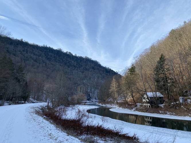
This hike follows the Pine Creek Trail (aka Pine Creek Rail Trail) starting from the Darling Run parking area.
Hike Description
This hike begins at the Darling Run parking area along the Pine Creek Trail near Wellsboro, PA and heads south along the trail as it winds through the PA Grand Canyon. Along the way, hikers will pass Darling Run - which can be explored further as a bushwhack to find Darling Run Falls - around mile 0.4.
Along the trail there are several nice views of Pine Creek and the steep hillsides of the gorge. Two noteworthy spots - if you know where to look is Barbour Rock and Kennedy Point.
Pinafore Run - Mile 1.75
At mile 1.75, hikers will reach Pinafore Run which passes directly underneath the Pine Creek Trail. Here, during mostly the Spring and after heavy rainfalls, hikers will find Lower Pinafore Falls (what used to be a 6-foot waterfall), located about 10-feet off of the trail from the Pine Creek Trail. Between writing this and my 2nd trip report 5 months later (Sept 2021 - Jan 2022), a storm had washed this waterfall away for the most part. Hikers can now easily head up into the creek where the rock has tumbled down - making for easy steps.
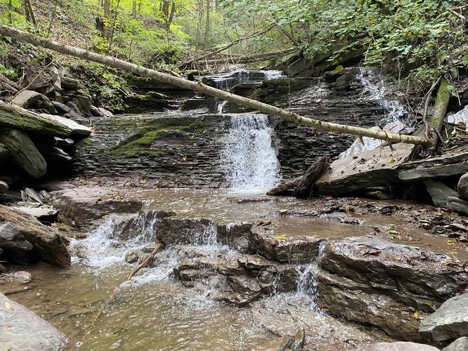
Hikers will begin their creek hike upstream where Pinafore Run meets the Pine Creek Trail. During months when the water level is lower, hikers - like I did (Admin) - can easily just follow the creek all the way upstream to reach Upper Pinafore Falls. The hike upstream is not easy, but at the worst is a moderate trek. It's easy to fall or get hurt within the rocks and small cliffs that the creek bed has to offer, so go slow and watch your step. Before reaching Upper Pinafore Falls, hikers will first hit "Middle Pinafore Falls" which is a series of three waterfalls - each about 4-feet tall with one 8 to 9-footer - that cascade down the creek. These waterfalls pose the largest obstacle to reach Upper Pinafore Falls. Here, I made my way up one of the waterfalls before skirting around the northern banks of the creek to bypass the other two to reach Upper Pinafore Falls.
Upper Pinafore Falls - End of Hike (Mile 1.95)
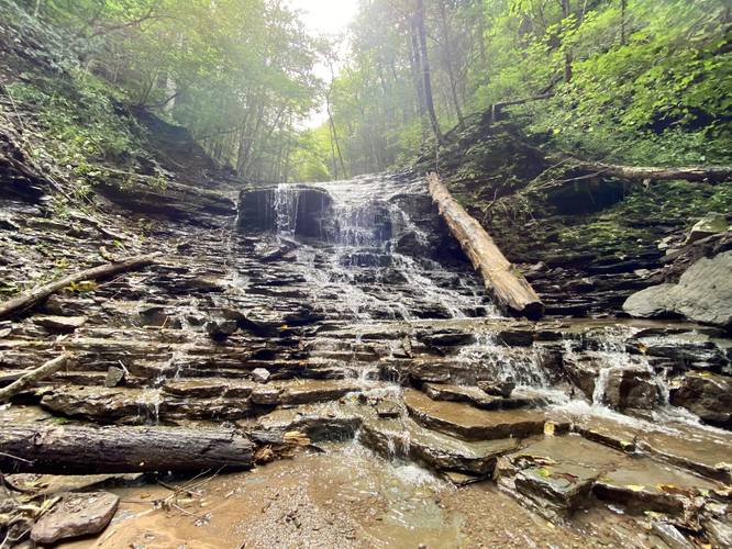
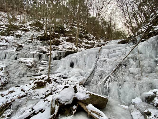
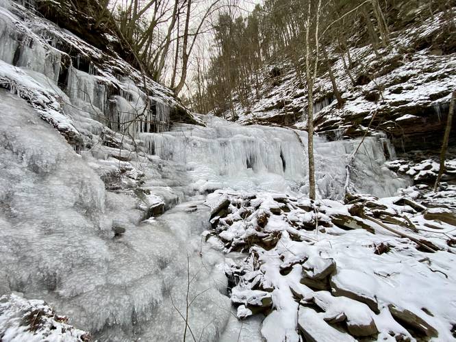
After passing the Middle Pinafore Falls section, hikers will reach Upper Pinafore Falls (aka Pinafore Falls) which cascades down Pinafore Run at about 20-feet tall. The upper portion of the waterfall is a slide waterfall that quickly cascades into a steeper rock slide waterfall. This beautiful waterfall is not necessarily easy to get to, hence to moderate difficulty. Note that there are waterfalls above Pinafore Falls; however, they're only accessible during the winter after deep freezes and for folks who are experienced and have the gear for ice climbing. Do not attempt to climb beyond Pinafore Falls outside of winter ice climbing, if you have actual experience, as it could be extremely dangerous.
Hiking Out
Obviously hiking back is not all that difficult - the main part is just to take it slow to make it out from Pinafore Run without hurting yourself. An alternative route up and out for this waterfall can be a bushwhack along the side of the creek - but watch your step as the banks of the creek are between 15 and 20 feet tall in some places.
Ice Climbing beyond Pinafore Falls (Ice Scale Falls & Wall Falls)
Experienced ice climbers can make their way up Pinafore Falls (Upper Pinafore Falls) to find more waterfalls upstream. Outside of ice climbing or rappelling down into Pinafore Run, the waterfalls above Pinafore Falls are generally considered inaccessible due to very steep, slippery, and rocky terrain. Accessing these waterfalls should only be attempted by folks who have experience climbing ice with proper gear (crampons, two ice axes, a helmet, harness, and some rope).
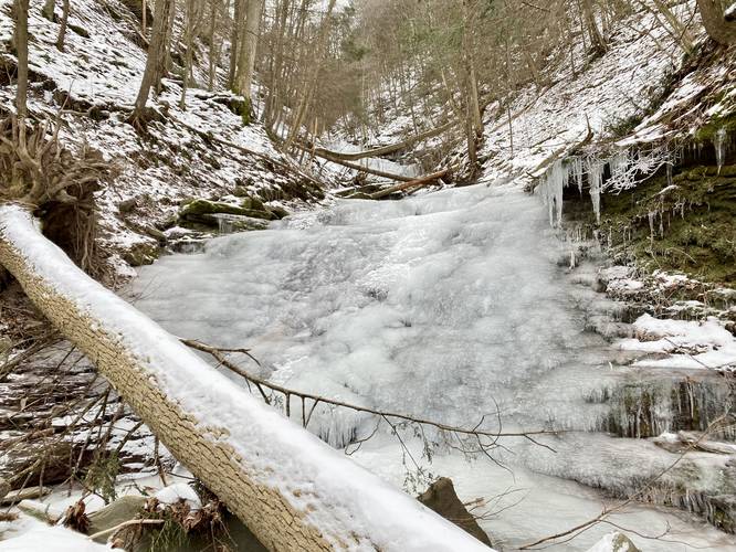
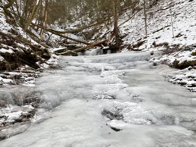
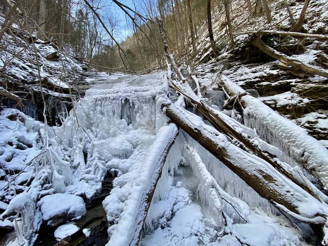
The terrain after Pinafore Falls is as follows: several 7-foot step-like waterfalls, a 13-foot waterfall that's almost impassible (can either ice climb it or in the winter scale the canyon hillside) which I've named Ice Scale Falls, another 7-foot long-sloped waterfall, then finally the 30-foot two-tier waterfall that I've named Wall Falls. Wall Falls waterfall (named after the Game of Thrones ice Wall) has a lower tier that's approximately 20-feet tall and an upper tier that's about 10-feet tall, both vertical. To the northern side of Wall Falls lies a seasonal stream that cascades down the canyon hillside, which freezes over during the winter into a super tall curtain — making this ravine a magical icy wonderland.
With regard to ice conditions on Pinafore Run, the ice is often not fully formed on the waterfalls themselves unless there's no free-fall cascade. Winter temperatures also rarely reach "safe" ice climbing conditions as of late, circa 2020 - 2025, with some exceptional winters and deep freezes. The creek will generally freeze over into a very thick continuous ice block for dozens of feet at a time — with the caveat that there are thin layers of ice that hover over running water, so every step must be checked before committing. The creek continues to flow under this ice and there are several deep pockets of running water (1+ feet deep) usually located at the base of each cascade. Be on the lookout for thin flaking ice, as you don't want to rely on the thin-layered shale rock below. Take each movement slowly and test your terrain before committing. Please note that I do not call out these waterfalls as challenges to the general public to explore or ice climb, but rather for experienced folks who can navigate climbing icy waterfalls and icy terrain on creek beds safely — and mainly to document my own experiences here.
Difficulty
This beautiful waterfall is not necessarily easy to get to, hence to moderate difficulty.
Parking
Hikers will find parking at the coordinates provided at the Darling Run parking area for the Pine Creek Trail.
Pets
Dogs are allowed if leashed and their waste must be carried out. Please note that the bushwhack to reach Mid-Pinafore Falls and Upper Pinafore Falls may not be suitable for dogs.
Warnings
Rocky slippery terrain: During warmer months, the terrain in Pinafore Run creek is slippery and rocky, which makes for a difficult upstream hike. This is for experienced creek hikers only.
Flash flooding: The terrain has changed here quite a bit since September 2021, which is when I first mapped this run and these waterfalls. In the 1.5-years since, two waterfalls have washed away - one 6-foot waterfall and one 4 or 5-foot cascade. Both waterfalls were washed away due to flash flooding. It's smart to only explore this creek during dry weather conditions and to always be on the lookout for dark storm clouds upstream.
Ice Climbing: I've stated this several times, ice climbing is really fun, but really dangerous along Pinafore Run. Only experienced ice climbers with proper gear should attempt hiking this creek during the winter. Any ice climbers attempting to go beyond Pinafore Falls (20-foot cascade located at mile 1.95) should be aware of the dangers upstream like the 13-foot Ice Scale Falls and several other waterfalls that need to be traversed to reach Wall Falls.
Timber Rattlesnakes: This area is home to the Timber Rattlesnake which can sometimes be found hunting or drinking along creeks between late April and early October.
Trails
This hike follows the Pine Creek Trail (aka Pine Creek Rail Trail) starting from the Darling Run parking area.
Hike Description
This hike begins at the Darling Run parking area along the Pine Creek Trail near Wellsboro, PA and heads south along the trail as it winds through the PA Grand Canyon. Along the way, hikers will pass Darling Run - which can be explored further as a bushwhack to find Darling Run Falls - around mile 0.4.
Along the trail there are several nice views of Pine Creek and the steep hillsides of the gorge. Two noteworthy spots - if you know where to look is Barbour Rock and Kennedy Point.
Pinafore Run - Mile 1.75
At mile 1.75, hikers will reach Pinafore Run which passes directly underneath the Pine Creek Trail. Here, during mostly the Spring and after heavy rainfalls, hikers will find Lower Pinafore Falls (what used to be a 6-foot waterfall), located about 10-feet off of the trail from the Pine Creek Trail. Between writing this and my 2nd trip report 5 months later (Sept 2021 - Jan 2022), a storm had washed this waterfall away for the most part. Hikers can now easily head up into the creek where the rock has tumbled down - making for easy steps.
Hikers will begin their creek hike upstream where Pinafore Run meets the Pine Creek Trail. During months when the water level is lower, hikers - like I did (Admin) - can easily just follow the creek all the way upstream to reach Upper Pinafore Falls. The hike upstream is not easy, but at the worst is a moderate trek. It's easy to fall or get hurt within the rocks and small cliffs that the creek bed has to offer, so go slow and watch your step. Before reaching Upper Pinafore Falls, hikers will first hit "Middle Pinafore Falls" which is a series of three waterfalls - each about 4-feet tall with one 8 to 9-footer - that cascade down the creek. These waterfalls pose the largest obstacle to reach Upper Pinafore Falls. Here, I made my way up one of the waterfalls before skirting around the northern banks of the creek to bypass the other two to reach Upper Pinafore Falls.
Upper Pinafore Falls - End of Hike (Mile 1.95)
After passing the Middle Pinafore Falls section, hikers will reach Upper Pinafore Falls (aka Pinafore Falls) which cascades down Pinafore Run at about 20-feet tall. The upper portion of the waterfall is a slide waterfall that quickly cascades into a steeper rock slide waterfall. This beautiful waterfall is not necessarily easy to get to, hence to moderate difficulty. Note that there are waterfalls above Pinafore Falls; however, they're only accessible during the winter after deep freezes and for folks who are experienced and have the gear for ice climbing. Do not attempt to climb beyond Pinafore Falls outside of winter ice climbing, if you have actual experience, as it could be extremely dangerous.
Hiking Out
Obviously hiking back is not all that difficult - the main part is just to take it slow to make it out from Pinafore Run without hurting yourself. An alternative route up and out for this waterfall can be a bushwhack along the side of the creek - but watch your step as the banks of the creek are between 15 and 20 feet tall in some places.
Ice Climbing beyond Pinafore Falls (Ice Scale Falls & Wall Falls)
Experienced ice climbers can make their way up Pinafore Falls (Upper Pinafore Falls) to find more waterfalls upstream. Outside of ice climbing or rappelling down into Pinafore Run, the waterfalls above Pinafore Falls are generally considered inaccessible due to very steep, slippery, and rocky terrain. Accessing these waterfalls should only be attempted by folks who have experience climbing ice with proper gear (crampons, two ice axes, a helmet, harness, and some rope).
The terrain after Pinafore Falls is as follows: several 7-foot step-like waterfalls, a 13-foot waterfall that's almost impassible (can either ice climb it or in the winter scale the canyon hillside) which I've named Ice Scale Falls, another 7-foot long-sloped waterfall, then finally the 30-foot two-tier waterfall that I've named Wall Falls. Wall Falls waterfall (named after the Game of Thrones ice Wall) has a lower tier that's approximately 20-feet tall and an upper tier that's about 10-feet tall, both vertical. To the northern side of Wall Falls lies a seasonal stream that cascades down the canyon hillside, which freezes over during the winter into a super tall curtain — making this ravine a magical icy wonderland.
With regard to ice conditions on Pinafore Run, the ice is often not fully formed on the waterfalls themselves unless there's no free-fall cascade. Winter temperatures also rarely reach "safe" ice climbing conditions as of late, circa 2020 - 2025, with some exceptional winters and deep freezes. The creek will generally freeze over into a very thick continuous ice block for dozens of feet at a time — with the caveat that there are thin layers of ice that hover over running water, so every step must be checked before committing. The creek continues to flow under this ice and there are several deep pockets of running water (1+ feet deep) usually located at the base of each cascade. Be on the lookout for thin flaking ice, as you don't want to rely on the thin-layered shale rock below. Take each movement slowly and test your terrain before committing. Please note that I do not call out these waterfalls as challenges to the general public to explore or ice climb, but rather for experienced folks who can navigate climbing icy waterfalls and icy terrain on creek beds safely — and mainly to document my own experiences here.
Difficulty
This beautiful waterfall is not necessarily easy to get to, hence to moderate difficulty.
Parking
Hikers will find parking at the coordinates provided at the Darling Run parking area for the Pine Creek Trail.
Pets
Dogs are allowed if leashed and their waste must be carried out. Please note that the bushwhack to reach Mid-Pinafore Falls and Upper Pinafore Falls may not be suitable for dogs.
Warnings
Rocky slippery terrain: During warmer months, the terrain in Pinafore Run creek is slippery and rocky, which makes for a difficult upstream hike. This is for experienced creek hikers only.
Flash flooding: The terrain has changed here quite a bit since September 2021, which is when I first mapped this run and these waterfalls. In the 1.5-years since, two waterfalls have washed away - one 6-foot waterfall and one 4 or 5-foot cascade. Both waterfalls were washed away due to flash flooding. It's smart to only explore this creek during dry weather conditions and to always be on the lookout for dark storm clouds upstream.
Ice Climbing: I've stated this several times, ice climbing is really fun, but really dangerous along Pinafore Run. Only experienced ice climbers with proper gear should attempt hiking this creek during the winter. Any ice climbers attempting to go beyond Pinafore Falls (20-foot cascade located at mile 1.95) should be aware of the dangers upstream like the 13-foot Ice Scale Falls and several other waterfalls that need to be traversed to reach Wall Falls.
Timber Rattlesnakes: This area is home to the Timber Rattlesnake which can sometimes be found hunting or drinking along creeks between late April and early October.