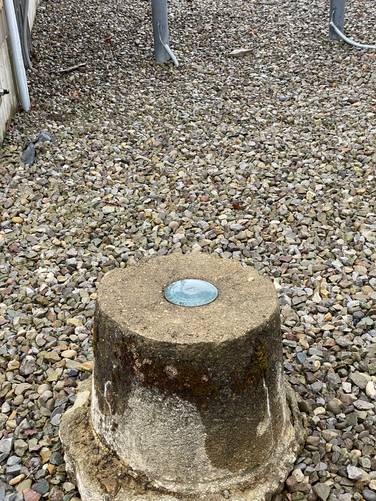
Grand View at Tioga State Forest near Gaines, Pennsylvania is an easy 1.4-mile out-and-back trail that leads to the top of Cedar Mountain's eastern summit and, as of July 2022, features a clear-cut area that provides hikers with sweeping south-facing views of Pine Creek Gorge (PA Grand Canyon), Armenia Mountain (with its massive wind turbines), Callahan Hilland, Gleason Hill, and other mountain peaks that jut out over the horizon located closed to Slate Run or Williamsport, PA. In addition, Cedar Mountain is Tioga County's highest point with this eastern peak sitting at approx. 2,543-feet.
Deer Fence - July, 2023
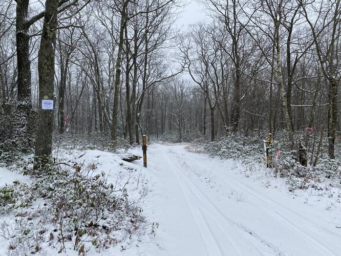
Note that as of July, 2023 there's now a deer fence surrounding the logged area at Grand View. For now, this impedes part of the view.
Temporary Vista
Note that this view is temporary and may last not much longer than ~15-years (circa 2037) because the understory will begin to take back the view; however, as of July 2022, Grand View on Cedar Mountain has some of the most spectacular and sweeping views in all of Tioga State Forest outside of the canyon.
Hike Description
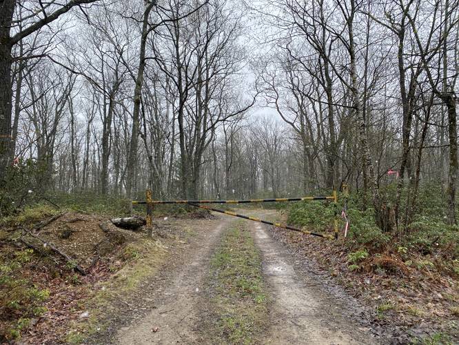
This hike begins along an unnamed forest service road, at the yellow gate, near the parking coordinates provided on Mill Run Road. The trail immediately starts by heading downhill toward a saddle in the mountain ridge. Not long after reaching the flat saddle of Cedar Mountain's ridge, the trail then begins to ascend to the eastern summit at a barely-moderate grade.
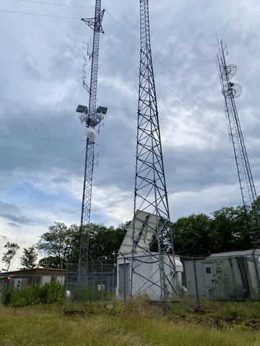
Radio Tower Station - Mile 0.5
Once at the top of Cedar Mountain, hikers will find a radio tower station around mile 0.5. Just beyond the radio tower station is the deforested area were hikers will find the views they showed up for - Grand View. Take a left-hand turn, to head down the logging path toward the views.
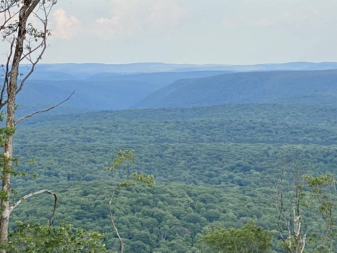
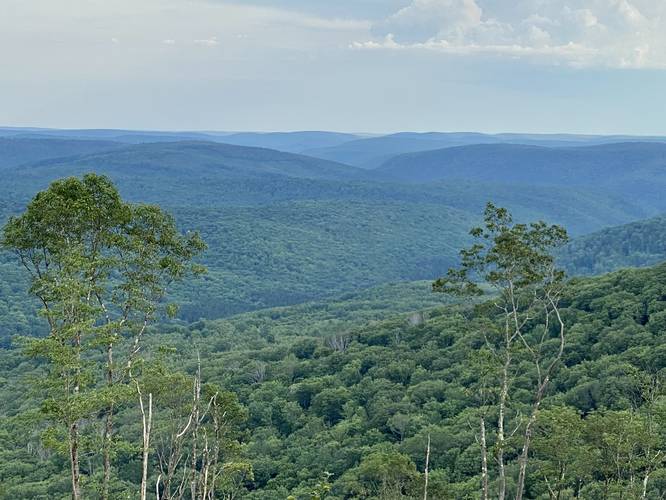
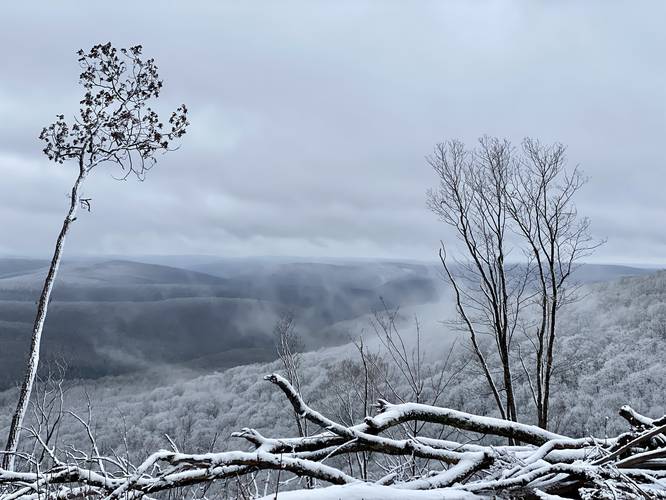
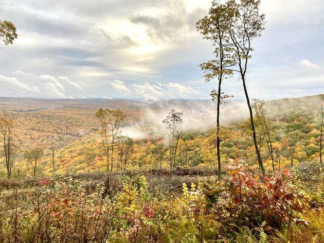
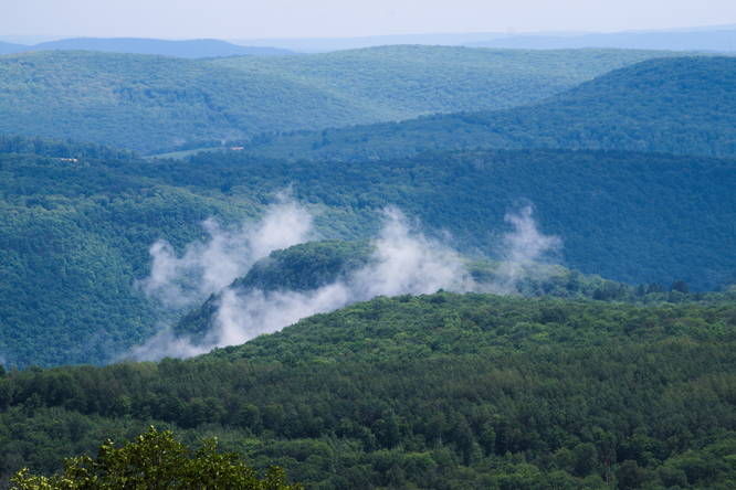
Grand View of Tioga State Forest - Mile 0.7
Around mile 0.6, hikers will begin to lose elevation, but will start to find better views as they head down the southeastern slopes of Cedar Mountain's "Grand View" by following the logging path. This recording stops at mile 0.7, at "Grand View", because the views were "grand enough" for this scouting hike and the bugs were starting to bother us; however, the logging path cuts around the forest floor in different directions, allowing for different vantage points if you want to explore more. On the left-hand side of Grand View is Pine Creek Gorge (PA Grand Canyon) as noted by its steep slopes. Above the canyon is Armenia Mountain with its massive white wind turbines. Hikers with a keen eye might notice a red ledge of rocky cliffs within the left-hand side of the canyon - this is Pine Island Vista. Just below the view, within the foreground, is a mountain range that has gradual sloping hills, but stands out like a low plateau - this is Callahan Hill. Behind Callahan Hill is Fahnestock Hill, as noted with its dramatic eastern slope that plunges into the canyon. On the right-hand side Gleason Hill stands out the most with Vanaimes Hill peaking its head out just behind it. To confuse things more, another mountain within Tioga State Forest, named Cedar Mountain, can be found just behind - and beyond - Fahnestock Hill and Vanaimes Hill. In the very far distance are more mountains and hills that peak over the horizon - like potentially Hemlock Mountain on the right-hand side.
Parking
Hikers will find a very small parking turnout by the forest gate and trailhead. The lot is large enough for a couple of vehicles. Do not block the forest gate.
Pets
Dogs are allowed if leashed and their waste should be carried out by the hiker.
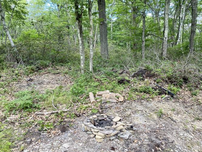
Camping and Backpacking
Note that dispersed / primitive / backcountry camping is allowed within Tioga State Forest and off of this trail. We found one campfire ring at the parking lot - which appeared to be a off-road car campsite. Please follow all state forest rules when disperse / primitive / backcountry camping at Tioga State Forest.
Warning
Timber Rattlesnakes: This area is known to inhabit the Timber Rattlesnake which can often be found sunning itself between late April and early October, especially on rocky outcroppings or in exposed areas, near downed trees, on-trail, or in the brush just off-trail.
No water: There's no water to filter along this route, so pack in everything you need.
Hunting & Service Gate
As of October 2022, the service road gate is open to hunters from October 15th - January 16th 2023. For hikers, it's probably best to walk this service road so that you don't put additional wear/tear on the road, leaving it less rutted for hunter's vehicles.
Deer Fence - July, 2023
Note that as of July, 2023 there's now a deer fence surrounding the logged area at Grand View. For now, this impedes part of the view.
Temporary Vista
Note that this view is temporary and may last not much longer than ~15-years (circa 2037) because the understory will begin to take back the view; however, as of July 2022, Grand View on Cedar Mountain has some of the most spectacular and sweeping views in all of Tioga State Forest outside of the canyon.
Hike Description
This hike begins along an unnamed forest service road, at the yellow gate, near the parking coordinates provided on Mill Run Road. The trail immediately starts by heading downhill toward a saddle in the mountain ridge. Not long after reaching the flat saddle of Cedar Mountain's ridge, the trail then begins to ascend to the eastern summit at a barely-moderate grade.
Radio Tower Station - Mile 0.5
Once at the top of Cedar Mountain, hikers will find a radio tower station around mile 0.5. Just beyond the radio tower station is the deforested area were hikers will find the views they showed up for - Grand View. Take a left-hand turn, to head down the logging path toward the views.
Grand View of Tioga State Forest - Mile 0.7
Around mile 0.6, hikers will begin to lose elevation, but will start to find better views as they head down the southeastern slopes of Cedar Mountain's "Grand View" by following the logging path. This recording stops at mile 0.7, at "Grand View", because the views were "grand enough" for this scouting hike and the bugs were starting to bother us; however, the logging path cuts around the forest floor in different directions, allowing for different vantage points if you want to explore more. On the left-hand side of Grand View is Pine Creek Gorge (PA Grand Canyon) as noted by its steep slopes. Above the canyon is Armenia Mountain with its massive white wind turbines. Hikers with a keen eye might notice a red ledge of rocky cliffs within the left-hand side of the canyon - this is Pine Island Vista. Just below the view, within the foreground, is a mountain range that has gradual sloping hills, but stands out like a low plateau - this is Callahan Hill. Behind Callahan Hill is Fahnestock Hill, as noted with its dramatic eastern slope that plunges into the canyon. On the right-hand side Gleason Hill stands out the most with Vanaimes Hill peaking its head out just behind it. To confuse things more, another mountain within Tioga State Forest, named Cedar Mountain, can be found just behind - and beyond - Fahnestock Hill and Vanaimes Hill. In the very far distance are more mountains and hills that peak over the horizon - like potentially Hemlock Mountain on the right-hand side.
Parking
Hikers will find a very small parking turnout by the forest gate and trailhead. The lot is large enough for a couple of vehicles. Do not block the forest gate.
Pets
Dogs are allowed if leashed and their waste should be carried out by the hiker.
Camping and Backpacking
Note that dispersed / primitive / backcountry camping is allowed within Tioga State Forest and off of this trail. We found one campfire ring at the parking lot - which appeared to be a off-road car campsite. Please follow all state forest rules when disperse / primitive / backcountry camping at Tioga State Forest.
Warning
Timber Rattlesnakes: This area is known to inhabit the Timber Rattlesnake which can often be found sunning itself between late April and early October, especially on rocky outcroppings or in exposed areas, near downed trees, on-trail, or in the brush just off-trail.
No water: There's no water to filter along this route, so pack in everything you need.
Hunting & Service Gate
As of October 2022, the service road gate is open to hunters from October 15th - January 16th 2023. For hikers, it's probably best to walk this service road so that you don't put additional wear/tear on the road, leaving it less rutted for hunter's vehicles.