The Spruce Tree Trail at Mesa Verde National Park, Colorado is an easy 0.2-mile one-way trail that leads down into the canyon and features views of the ancient Puebloan cliff dwellings known as the Spruce Tree House.
Hike
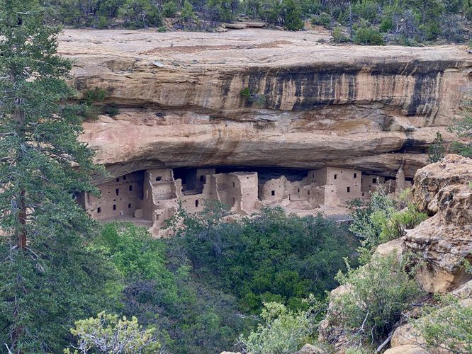
This short trail is one of the best walks in the park as it leads to some of the best, and closest views, you'll get of some of the ancient Puebloan cliff dwellings. From the Spruce Tree Trail, you'll get views into Spruce Canyon as you make your way down this paved, universally-accessible trail. Not long after walking down the first switchback from the Museum, you'll start to find views of the Spruce Tree House. There are benches at the overlook which you can use to relax and take-in the views. The trail continues heading down into the canyon, following switchbacks along the way. Eventually it ends at the trailhead for the Petroglyph Point Loop Trail and the Spruce Canyon Loop Trail. We used this trail as part of a day hike loop with the Petroglyph Point Loop Trail, which you can consider taking a hike on as well -- both trails combined creates a ~3-mile loop hike.
Spruce Tree House Closure (2015 - Present)
Note that since 2015, the Spruce Tree House has been closed due to rockfall. Unsure of when the complex might re-open to hikers that want to peer inside (only when a ranger is present), as the signage in June 2024 did not indicate a re-opening plan. Despite not being able to step inside the complex, the views from the trail are well-worth the visit here.
Universal Access
This trail follows a paved and universally-accessible pathway as of June 2024.
Parking
Visitors will find a parking lot at the coordinates provided along Chapin Museum Road in the park. As of June 2024, the lot is large enough to fit several dozens of vehicles.
Pets
Dogs are not allowed on this trail. Dogs are allowed on paved trails including the Park Point Trail and the Mesa Top Loop Sites including: The Navajo Canyon Overlook, Square Tower House Overlook Trail, Pithouses & Pueblos Loop, Mesa Top Sites Trail, Sun Point Pueblo, Sun Point View, Oak Tree House View, Fire Temple & New Fire House View, and the Sun Temple & Cliff Palace View.
Warning
Steep cliffs: This trail leads out to tall and steep cliffs.
Hike
This short trail is one of the best walks in the park as it leads to some of the best, and closest views, you'll get of some of the ancient Puebloan cliff dwellings. From the Spruce Tree Trail, you'll get views into Spruce Canyon as you make your way down this paved, universally-accessible trail. Not long after walking down the first switchback from the Museum, you'll start to find views of the Spruce Tree House. There are benches at the overlook which you can use to relax and take-in the views. The trail continues heading down into the canyon, following switchbacks along the way. Eventually it ends at the trailhead for the Petroglyph Point Loop Trail and the Spruce Canyon Loop Trail. We used this trail as part of a day hike loop with the Petroglyph Point Loop Trail, which you can consider taking a hike on as well -- both trails combined creates a ~3-mile loop hike.
Spruce Tree House Closure (2015 - Present)
Note that since 2015, the Spruce Tree House has been closed due to rockfall. Unsure of when the complex might re-open to hikers that want to peer inside (only when a ranger is present), as the signage in June 2024 did not indicate a re-opening plan. Despite not being able to step inside the complex, the views from the trail are well-worth the visit here.
Universal Access
This trail follows a paved and universally-accessible pathway as of June 2024.
Parking
Visitors will find a parking lot at the coordinates provided along Chapin Museum Road in the park. As of June 2024, the lot is large enough to fit several dozens of vehicles.
Pets
Dogs are not allowed on this trail. Dogs are allowed on paved trails including the Park Point Trail and the Mesa Top Loop Sites including: The Navajo Canyon Overlook, Square Tower House Overlook Trail, Pithouses & Pueblos Loop, Mesa Top Sites Trail, Sun Point Pueblo, Sun Point View, Oak Tree House View, Fire Temple & New Fire House View, and the Sun Temple & Cliff Palace View.
Warning
Steep cliffs: This trail leads out to tall and steep cliffs.