The Mesa Top Sites Trail at Mesa Verde National Park, Colorado is an easy 0.1-mile out-and-back universally-accessible trail that features ancient Puebloan pithouses and kivas from the 900 - 1100 CE era.
Walk
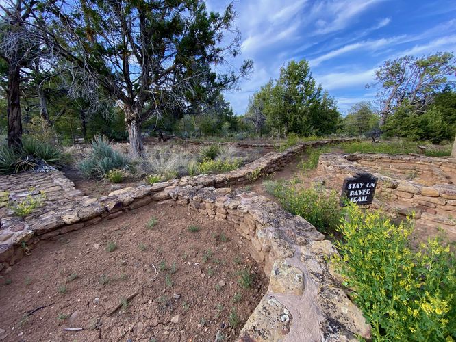
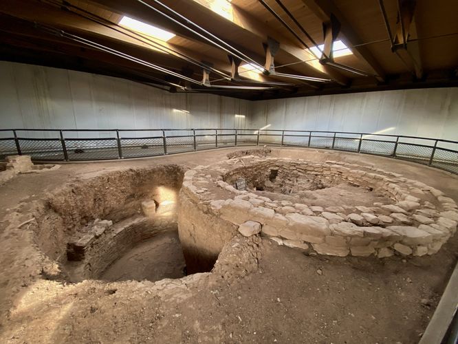
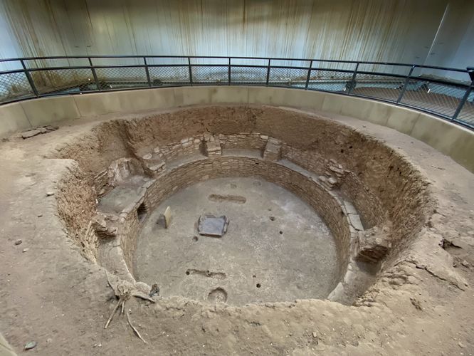
This is not a hike but rather a short walk along a universally-accessible trail out to view ancient pithouses built by the ancient Peubloans ~1,000 years ago. The trail first starts off by stopping at a "village upon a village" which appears like a series of rock walls that are somewhat scattered atop one another. This is an example of how the ancient Puebloans repurposed existing buildings and villages to build new structures directly on-top. Inside the protective shed along the trail lies the ancient Puebloan pithouses. The architecture dates back to the 900 - 1100 CE era. Around 1100 is when the Puebloans started building multi-story villages as well. After exploring the pithouses, the walk back to parking completes this very short 0.1-mile jaunt.
Universal Access
This is a paved and universally-accessible pathway as of June 2024.
Parking
Visitors will find a parking lot at the coordinates provided along Mesa Top Loop Road in the park. As of June 2024, the lot is large enough to fit approximately a dozen vehicles.
Pets
Dogs are allowed on this trail and must be cleaned and cleaned up after. Dogs are allowed on paved trails including the Park Point Trail and the Mesa Top Loop Sites including: The Navajo Canyon Overlook, Square Tower House Overlook Trail, Pithouses & Pueblos Loop, Mesa Top Sites Trail, Sun Point Pueblo, Sun Point View, Oak Tree House View, Fire Temple & New Fire House View, and the Sun Temple & Cliff Palace View.
Warning
Steep cliffs: This trail leads out to tall and steep cliffs.
Walk
This is not a hike but rather a short walk along a universally-accessible trail out to view ancient pithouses built by the ancient Peubloans ~1,000 years ago. The trail first starts off by stopping at a "village upon a village" which appears like a series of rock walls that are somewhat scattered atop one another. This is an example of how the ancient Puebloans repurposed existing buildings and villages to build new structures directly on-top. Inside the protective shed along the trail lies the ancient Puebloan pithouses. The architecture dates back to the 900 - 1100 CE era. Around 1100 is when the Puebloans started building multi-story villages as well. After exploring the pithouses, the walk back to parking completes this very short 0.1-mile jaunt.
Universal Access
This is a paved and universally-accessible pathway as of June 2024.
Parking
Visitors will find a parking lot at the coordinates provided along Mesa Top Loop Road in the park. As of June 2024, the lot is large enough to fit approximately a dozen vehicles.
Pets
Dogs are allowed on this trail and must be cleaned and cleaned up after. Dogs are allowed on paved trails including the Park Point Trail and the Mesa Top Loop Sites including: The Navajo Canyon Overlook, Square Tower House Overlook Trail, Pithouses & Pueblos Loop, Mesa Top Sites Trail, Sun Point Pueblo, Sun Point View, Oak Tree House View, Fire Temple & New Fire House View, and the Sun Temple & Cliff Palace View.
Warning
Steep cliffs: This trail leads out to tall and steep cliffs.