The Square Tower House Overlook Trail at Mesa Verde National Park is an easy 0.2-mile out-and-back universally-accessible trail that leads to views of ancient canyon alcove dwellings called the Square Tower House.
Walk
This trail begins at the main trailhead for the Square Tower House Overlook (A.D. 1200 - 1300) and leads down a series of stairs to reach a paved pathway that leads out to the overlook. This is just one of two trailheads for this trail as the second can be found just up the one-way road where you'll find a universally-accessible trailhead that leads into the same place.
The trail leads through the scrubland forest with low-growing trees and (potentially) flowering Banana Yucca plants that line the trail.
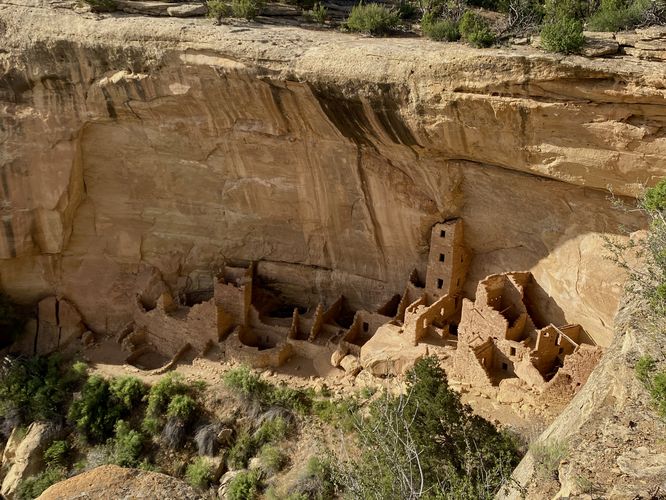
Square Tower House Overlook - Mile 0.1
Around mile 0.1, you'll reach the cliff's edge where you'll find views of the canyon and the ancient cliff alcove dwellings below you. The Square Tower House dwellings are located below your feet and to the right-hand side and can't be missed. These dwellings date back to ~1200 - 1300 A.D.. Interestingly enough, the trails that ancient Puebloans used to hike up and construct this alcove are still used today, only by authorized and permitted researchers.
After exploring the ancient alcove dwellings of the Square Tower House complex, the trail leads back to parking for a short 0.2-mile out-and-back walk.
Universal Access
This is a paved and universally-accessible pathway as of June 2024.
Parking
Visitors will find a parking lot at the coordinates provided along Mesa Top Loop Road in the park. As of June 2024, the lot is large enough to fit approximately a dozen vehicles.
Pets
Dogs are allowed on this trail and must be cleaned and cleaned up after. Dogs are allowed on paved trails including the Park Point Trail and the Mesa Top Loop Sites including: The Navajo Canyon Overlook, Square Tower House Overlook Trail, Pithouses & Pueblos Loop, Mesa Top Sites Trail, Sun Point Pueblo, Sun Point View, Oak Tree House View, Fire Temple & New Fire House View, and the Sun Temple & Cliff Palace View.
Warning
Steep cliffs: This trail leads out to tall and steep cliffs.
Walk
This trail begins at the main trailhead for the Square Tower House Overlook (A.D. 1200 - 1300) and leads down a series of stairs to reach a paved pathway that leads out to the overlook. This is just one of two trailheads for this trail as the second can be found just up the one-way road where you'll find a universally-accessible trailhead that leads into the same place.
The trail leads through the scrubland forest with low-growing trees and (potentially) flowering Banana Yucca plants that line the trail.
Square Tower House Overlook - Mile 0.1
Around mile 0.1, you'll reach the cliff's edge where you'll find views of the canyon and the ancient cliff alcove dwellings below you. The Square Tower House dwellings are located below your feet and to the right-hand side and can't be missed. These dwellings date back to ~1200 - 1300 A.D.. Interestingly enough, the trails that ancient Puebloans used to hike up and construct this alcove are still used today, only by authorized and permitted researchers.
After exploring the ancient alcove dwellings of the Square Tower House complex, the trail leads back to parking for a short 0.2-mile out-and-back walk.
Universal Access
This is a paved and universally-accessible pathway as of June 2024.
Parking
Visitors will find a parking lot at the coordinates provided along Mesa Top Loop Road in the park. As of June 2024, the lot is large enough to fit approximately a dozen vehicles.
Pets
Dogs are allowed on this trail and must be cleaned and cleaned up after. Dogs are allowed on paved trails including the Park Point Trail and the Mesa Top Loop Sites including: The Navajo Canyon Overlook, Square Tower House Overlook Trail, Pithouses & Pueblos Loop, Mesa Top Sites Trail, Sun Point Pueblo, Sun Point View, Oak Tree House View, Fire Temple & New Fire House View, and the Sun Temple & Cliff Palace View.
Warning
Steep cliffs: This trail leads out to tall and steep cliffs.