The Petroglyph Point Loop Trail at Mesa Verde National Park, Colorado is a moderate 2.6-mile loop hike that features canyon views along with ancient Puebloan petroglyphs and dwelling structures.
Hike
This hike begins at the main trailhead for the Petroglyph Point Loop Trail, located at the very end of the Spruce Tree Trail. Note that this trail must be hiked counter-clockwise, starting at the bottom of Spruce Canyon due to the uphill cliff scrambles that you'll have to traverse to hike back. Hikers will head-in along the main path, passing trailhead info signs, before reaching a fork in the trail. Follow the signage labeled "Petroglyph" and take a left-hand turn to stay on the proper route. From here, the trail leads up into the canyon's cliff sides following a trail riddled with boulders and rocks.
Skinny Rock Tunnel & Stairs - Mile 0.2
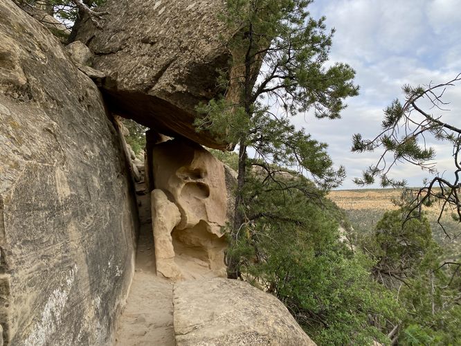
Around mile 0.2, hikers will reach an interesting feature in the trail where the path leads through a massive boulder tunnel created by one boulder sitting atop another. This skinny pathway isn't difficult to traverse but for the claustrophobic, it might not be very fun. On the other side of the rock tunnel, you'll find views of Spruce Canyon before the trail descends following a series of very-skinny rock stairs.
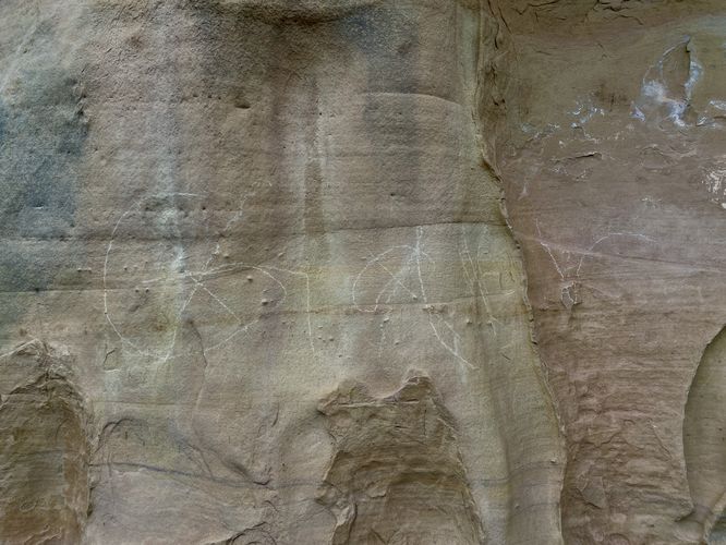
The trail then follows the cliff's edge, passing in and out of bends in the cliff face where you might find interesting alcoves. The trail hits several switchbacks before running along the edge of the canyon for a fairly-long straightaway, passing some Spruce Canyon views around mile 0.4. At mile 0.55, you might notice some scratch marks in the cliff's rock walls. These appear to be some form of ancient petroglyph, but they're not the main attraction along the trail.
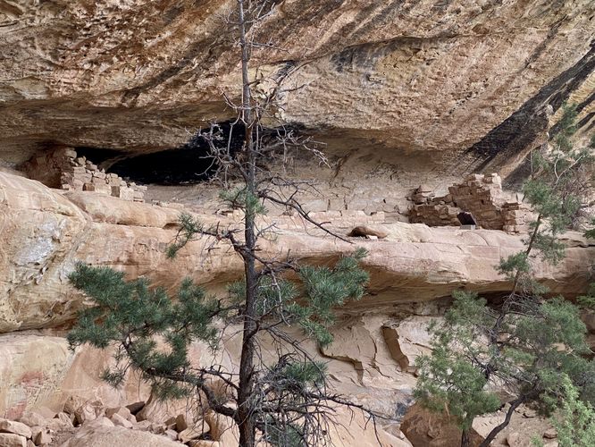
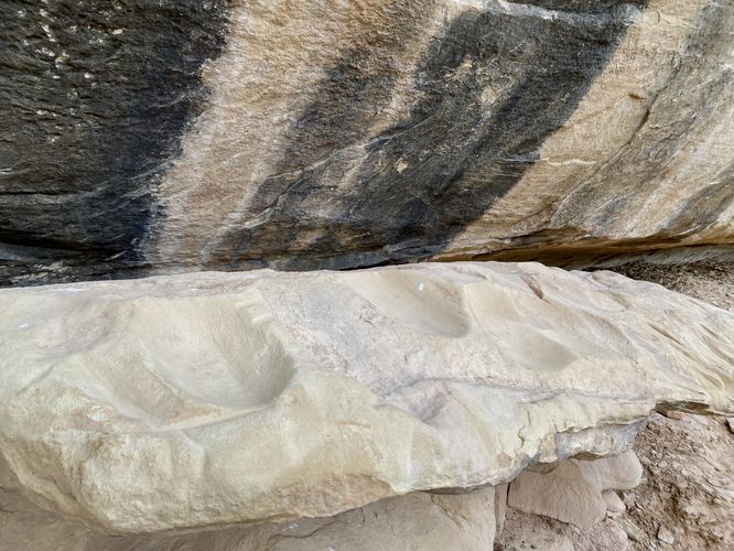
Alcove Dwelling Structure & Grinding Stone - Mile 0.77 to 0.79
Around mile 0.77, hikers will follow the trail downhill into a cliff alcove area where you'll find ancient Puebloan dwelling structures in the cliff just one tier above the trail. As the trail winds around the bend in the canyon, it leads to two large grinding stones that the ancient people used. You can still see the smooth grooved surfaces of the stone as it was slowly eroded over time by friction.
Hiking an Ancient Pathway
After exploring the ancient structures and evidence of a people long-gone, you'll realize that the trail you're walking on was used by those same people hundreds of years ago, circa ~1000 - 1200 CE.
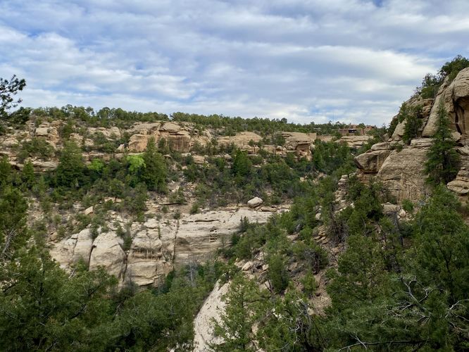
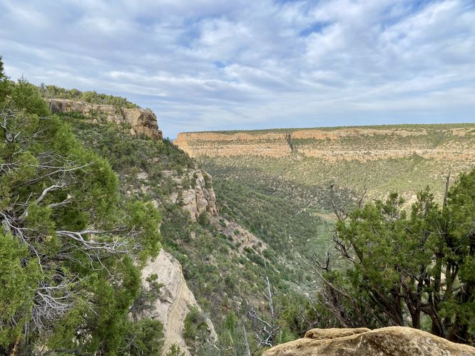
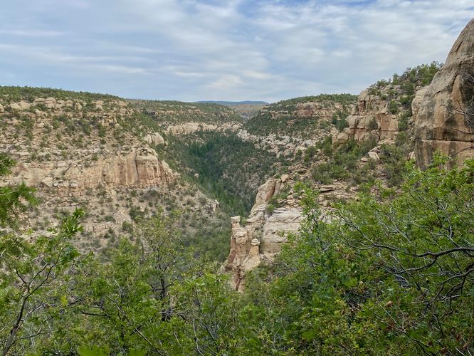
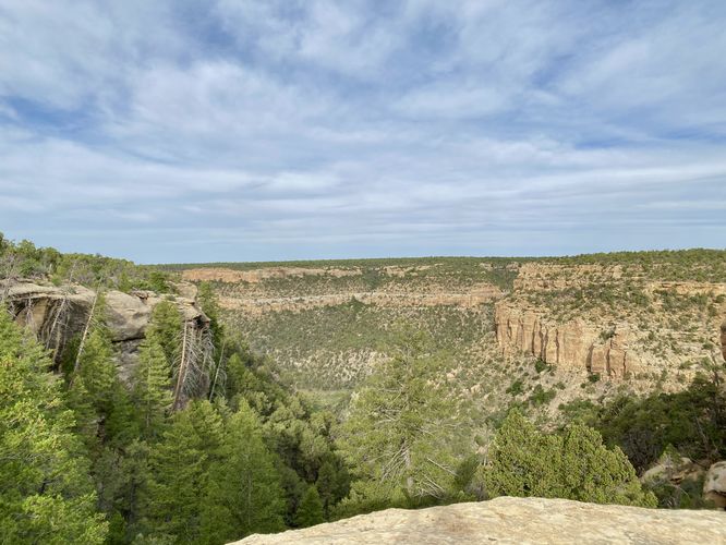
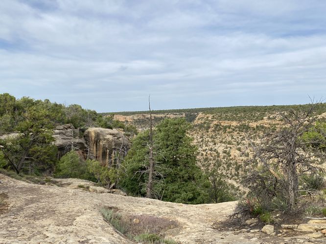
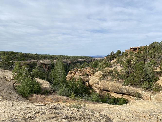
From here, the trail leads further along the canyon's edge, passing several different views and vistas of Spruce Canyon and Navajo Canyon as you make your way closer to the petroglyph wall of Petroglyph Point.
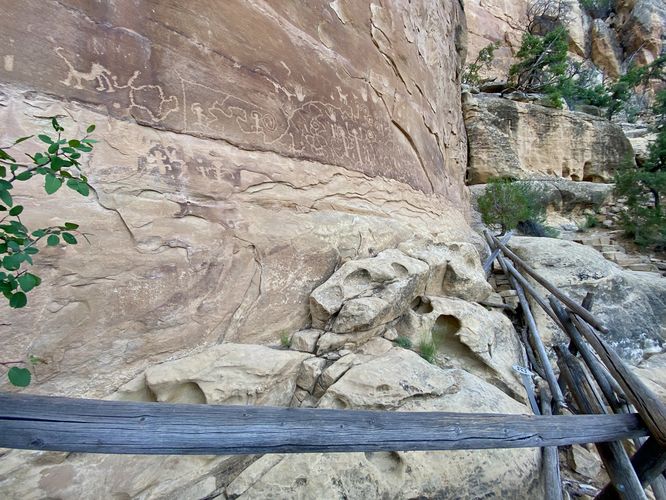
Petroglyph Point, Petroglyphs Wall - Mile 1.25
The trail eventually leads to a large petroglyph wall, located around mile 1.25, which is how the trail got its name Petroglyph Point. At the petroglyph wall, you'll know you made it when you find the wooden fence that sits along the wall - reminding hikers to keep back from the ancient artwork. On the wall, you'll spot different shapes and animals -- one of which is a petroglyph for the Mountain Lion Clan.
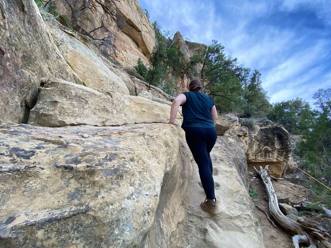
Cliff Side Rock Scramble - Mile 1.26 to 1.3
Just after the Petroglyph Wall of Petroglyph Point, the trail begins to the ascend the canyon's walls via a series of rock scrambles. These rock scrambles are not technically challenging -- at most are 5-feet tall with some foot/hand holds to help -- but the challenge is mentally preparing and keeping your focus on the uphill climb. The cliff face and tiers provides plenty of room to walk and scramble your way up the canyon. It eventually ends around mile 1.3. The trail skirts along a steep cliff with bedrock and boulders that provide, a maximum, of 3-feet wide before the trail is officially on the rim of the canyon.
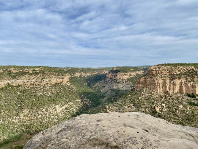
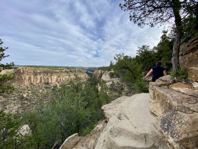
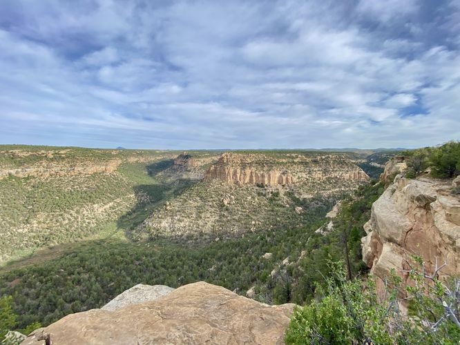
Rim Hike & Views - Mile 1.35 to 2.6 (End of Trail)
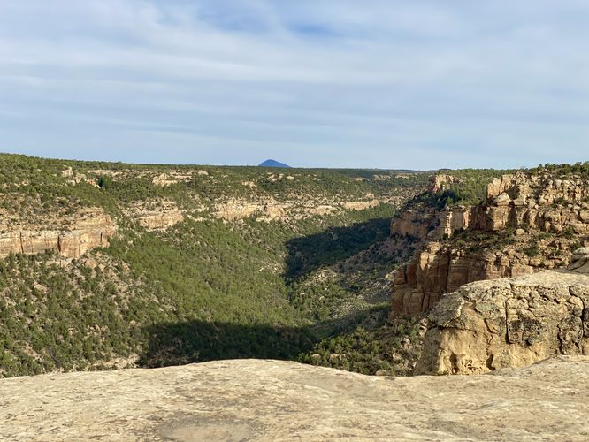
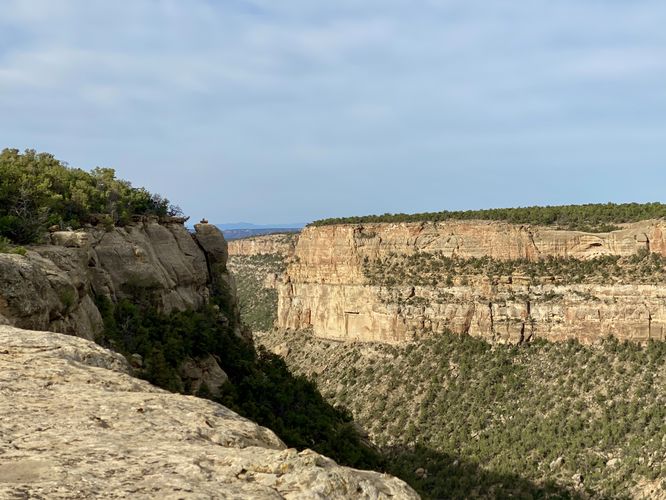
Once at the rim of the canyon, the trail follows an undulating path that runs along the rim, passing views and vistas along the way. Most of the view you'll find along this part of the hike are that of Navajo Canyon and Spruce Canyon. You'll also find Ute Mountain poking its summit over the top of the horizon. Despite the park's stated mileage (which appears to be off), the trail runs until mile 2.6 where it crosses a concrete barrier that sits just above the north side of Spruce Tree House. The trail then connects back to the Spruce Tree Trail to complete the hike.
Parking
Hikers will find a parking lot at the coordinates provided along Chapin Museum Road in the park. As of June 2024, the lot is large enough to fit several dozens of vehicles.
Pets
Dogs are not allowed on this trail. Dogs are allowed on paved trails including the Park Point Trail and the Mesa Top Loop Sites including: The Navajo Canyon Overlook, Square Tower House Overlook Trail, Pithouses & Pueblos Loop, Mesa Top Sites Trail, Sun Point Pueblo, Sun Point View, Oak Tree House View, Fire Temple & New Fire House View, and the Sun Temple & Cliff Palace View.
Warning
Steep cliffs: This trail leads out to tall and steep cliffs.
Rattlesnakes: Mesa Verde is home to rattlesnakes that might be out basking in the sun during warm months. While encounters are rare, give any rattlers you find plenty of space.
Sun exposure: Due to the lack of trees and shade, this trail has a high exposure to the sun and weather. Plan to bring sunscreen to protect yourself against high UVs.
Cliff side rock scrambles: This trail must be hiked counter-clockwise in order to hike up the canyon. Doing so follows at least a few rock scrambles that reside along fairly-steep cliff sides. Note that this sounds a lot more terrifying than it was when we were on the trail; however, everyone has a different sense of what a scary hike entails. Before committing to the hike, know that the scrambles are no more than ~4-5 feet tall and there's a generous amount of space along the rock. The scariest part is likely just looking down the scrambles, so keep your focus on making your way up and out.
Ancient petroglyphs: This trail leads to ancient petroglyphs that should never be touched, disturbed, or defaced. Additionally, defacing ancient petroglyphs is a federal crime, so please take only pictures and do not touch the ancient artwork.
Hike
This hike begins at the main trailhead for the Petroglyph Point Loop Trail, located at the very end of the Spruce Tree Trail. Note that this trail must be hiked counter-clockwise, starting at the bottom of Spruce Canyon due to the uphill cliff scrambles that you'll have to traverse to hike back. Hikers will head-in along the main path, passing trailhead info signs, before reaching a fork in the trail. Follow the signage labeled "Petroglyph" and take a left-hand turn to stay on the proper route. From here, the trail leads up into the canyon's cliff sides following a trail riddled with boulders and rocks.
Skinny Rock Tunnel & Stairs - Mile 0.2
Around mile 0.2, hikers will reach an interesting feature in the trail where the path leads through a massive boulder tunnel created by one boulder sitting atop another. This skinny pathway isn't difficult to traverse but for the claustrophobic, it might not be very fun. On the other side of the rock tunnel, you'll find views of Spruce Canyon before the trail descends following a series of very-skinny rock stairs.
The trail then follows the cliff's edge, passing in and out of bends in the cliff face where you might find interesting alcoves. The trail hits several switchbacks before running along the edge of the canyon for a fairly-long straightaway, passing some Spruce Canyon views around mile 0.4. At mile 0.55, you might notice some scratch marks in the cliff's rock walls. These appear to be some form of ancient petroglyph, but they're not the main attraction along the trail.
Alcove Dwelling Structure & Grinding Stone - Mile 0.77 to 0.79
Around mile 0.77, hikers will follow the trail downhill into a cliff alcove area where you'll find ancient Puebloan dwelling structures in the cliff just one tier above the trail. As the trail winds around the bend in the canyon, it leads to two large grinding stones that the ancient people used. You can still see the smooth grooved surfaces of the stone as it was slowly eroded over time by friction.
Hiking an Ancient Pathway
After exploring the ancient structures and evidence of a people long-gone, you'll realize that the trail you're walking on was used by those same people hundreds of years ago, circa ~1000 - 1200 CE.
From here, the trail leads further along the canyon's edge, passing several different views and vistas of Spruce Canyon and Navajo Canyon as you make your way closer to the petroglyph wall of Petroglyph Point.
Petroglyph Point, Petroglyphs Wall - Mile 1.25
The trail eventually leads to a large petroglyph wall, located around mile 1.25, which is how the trail got its name Petroglyph Point. At the petroglyph wall, you'll know you made it when you find the wooden fence that sits along the wall - reminding hikers to keep back from the ancient artwork. On the wall, you'll spot different shapes and animals -- one of which is a petroglyph for the Mountain Lion Clan.
Cliff Side Rock Scramble - Mile 1.26 to 1.3
Just after the Petroglyph Wall of Petroglyph Point, the trail begins to the ascend the canyon's walls via a series of rock scrambles. These rock scrambles are not technically challenging -- at most are 5-feet tall with some foot/hand holds to help -- but the challenge is mentally preparing and keeping your focus on the uphill climb. The cliff face and tiers provides plenty of room to walk and scramble your way up the canyon. It eventually ends around mile 1.3. The trail skirts along a steep cliff with bedrock and boulders that provide, a maximum, of 3-feet wide before the trail is officially on the rim of the canyon.
Rim Hike & Views - Mile 1.35 to 2.6 (End of Trail)
Once at the rim of the canyon, the trail follows an undulating path that runs along the rim, passing views and vistas along the way. Most of the view you'll find along this part of the hike are that of Navajo Canyon and Spruce Canyon. You'll also find Ute Mountain poking its summit over the top of the horizon. Despite the park's stated mileage (which appears to be off), the trail runs until mile 2.6 where it crosses a concrete barrier that sits just above the north side of Spruce Tree House. The trail then connects back to the Spruce Tree Trail to complete the hike.
Parking
Hikers will find a parking lot at the coordinates provided along Chapin Museum Road in the park. As of June 2024, the lot is large enough to fit several dozens of vehicles.
Pets
Dogs are not allowed on this trail. Dogs are allowed on paved trails including the Park Point Trail and the Mesa Top Loop Sites including: The Navajo Canyon Overlook, Square Tower House Overlook Trail, Pithouses & Pueblos Loop, Mesa Top Sites Trail, Sun Point Pueblo, Sun Point View, Oak Tree House View, Fire Temple & New Fire House View, and the Sun Temple & Cliff Palace View.
Warning
Steep cliffs: This trail leads out to tall and steep cliffs.
Rattlesnakes: Mesa Verde is home to rattlesnakes that might be out basking in the sun during warm months. While encounters are rare, give any rattlers you find plenty of space.
Sun exposure: Due to the lack of trees and shade, this trail has a high exposure to the sun and weather. Plan to bring sunscreen to protect yourself against high UVs.
Cliff side rock scrambles: This trail must be hiked counter-clockwise in order to hike up the canyon. Doing so follows at least a few rock scrambles that reside along fairly-steep cliff sides. Note that this sounds a lot more terrifying than it was when we were on the trail; however, everyone has a different sense of what a scary hike entails. Before committing to the hike, know that the scrambles are no more than ~4-5 feet tall and there's a generous amount of space along the rock. The scariest part is likely just looking down the scrambles, so keep your focus on making your way up and out.
Ancient petroglyphs: This trail leads to ancient petroglyphs that should never be touched, disturbed, or defaced. Additionally, defacing ancient petroglyphs is a federal crime, so please take only pictures and do not touch the ancient artwork.