Loading...

🍁 Fall is here! Check out our foliage map to plan your autumn hikes! Learn more.

Mürrenbach Falls

Directions
Map
Pictures
Send to App
Distance:
0.5 km / 0.3 Miles
Type:
Out-and-Back
Difficulty:
Easy
Time to Hike:
~9 minutes
Features:
Surface Type:
Dirt
Town:
Lauterbrunnen, Switzerland
Get Directions:
46.556138, 7.901215
Added:
September 15, 2025
Updated:
October 16, 2025
Copy Trail Link Hiking this trail? Send a friend or family member a link to this trail guide for your own safety. Hike at your own risk (disclaimer)
Loading...
Loading...
5m

Total Change
5m

Ascent
5m

Descent

Download the Trail Route for Offline Use

Supporters get exclusive access to download trail routes to the MyHikes app for offline use. Stay prepared on your adventure, even without an internet connection! Become a Supporter today to unlock this feature and hike with confidence.

Send to App

Key Takeaways

  • Discover the 417m free-falling Mürrenbach Falls, one of the largest but most unvisited waterfalls in the Lauterbrunnen Valley.
  • Enjoy a quick 0.5km out-and-back trail to the waterfall's base, offering a secluded experience away from the crowds.
  • Get stunning, unique perspectives of the Lauterbrunnen Valley, surrounding Alps, and the cliff face from the trail near Parkplatz Stechelberg.

Mürrenbach Falls

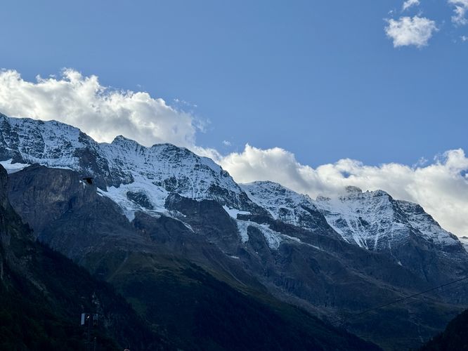
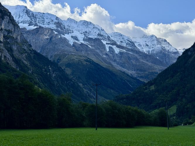
Mürrenbachfall (Mürrenbach Falls), nestled on the southwest side of Switzerland's Lauterbrunnen Valley, is a 417m tall free-falling waterfall. This guide will lead you along a short 0.5km out-and-back walk to reach the base of Mürrenbachfall where you'll also find stunning views of the Lauterbrunnen Valley and surrounding glacier-capped Alps.

Visit Mürrenbachfall

Tourists in the Lauterbrunnen Valley tend to explore Staubbach Falls and Trümmelbach Falls, but completely skip one of the largest waterfalls in the area — Mürrenbach Falls. The start of this short walk begins at a large paid parking lot, Parkplatz Stechelberg (Schilthornbahn), where a trailhead sits in the southwest corner of the lot.

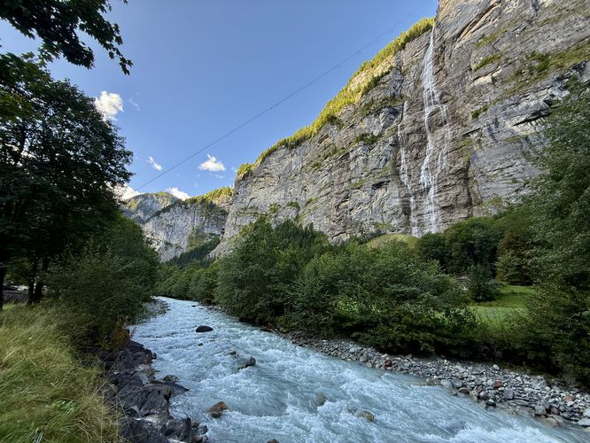
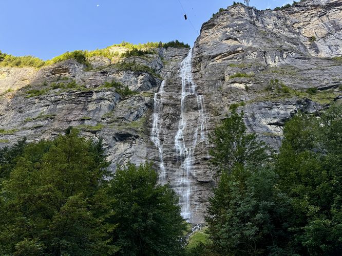
As you walk over the Weisse Lütschine river bridge, you'll find plenty of views of the surrounding Alps, the turquiose-tinted glacial waters of the river, and the 417m (1,367-feet) tall Mürrenbach Falls as it plummets over the side of the Mürren cliff.

Visitors can simply enjoy the waterfall from the bridge, or follow the Sagen-Trail Stetchelberg through the Lauterbrunnen Valley, as this route does, to enjoy slightly different perspectives and views of the waterfall, valley cliffs, and surrounding Alps.

You may even notice that the trail is fairly empty, if not completely void of other people. Most visitors to the area will hop on the gondola / lift that stretches high above the valley to reach the quaint village of Mürren. The cable car rises above the valley with a full view of Mürrenbach Falls along the way, so walking out to the base of the waterfall is a less popular option and hence, it's one of the most secluded trails in the entire Lauterbrunnen Valley.

When done enjoying the sights, sounds, and views of Mürrenbach Falls, the trail leads straight back to parking to wrap up this very short and easy 0.5km walk.

Explore the Lauterbrunnen Valley

For more adventures in the Lauterbrunnen Valley, consider exploring the Lauterbrunnen Valley Loop, Trümmelbach Falls, and Staubbach Falls.

Parking

Visitors will find a parking lot at the coordinates provided at Parkplatz Stechelberg (Schilthornbahn). The lot is massive and can hold over 100 vehicles as of September 2025. The parking lot is a paid lot based on your time parked. If you spend ~20 minutes or less exploring the waterfall and trail, parking is free. Remember to always validate your parking ticket with the machines located at the gondola/lift before you attempt to exit.

Pets

Dogs are allowed only if leashed and cleaned up after.

Warning

Falling rock: Due to the nature of the Lauterbrunnen Valley, rockfall can happen at any time especially around areas with flowing water. Hence, the signage to keep back from the cliff and stay on-trail at all times. Rockfall may occur at any time, so play it safe and stay on-trail.
Explore 7 trails near Lauterbrunnen, Switzerland
  1. Parking

    46.556138, 7.901215
  2. Main Trailhead

    46.556138, 7.901215
  3. View of glacier-capped Alps tower over the Lauterbrunnen Valley

    46.556031, 7.901156
    View of glacier-capped Alps tower over the Lauterbrunnen Valley
  4. View of Murrenbach Falls and the Weisse Lütschine river

    46.555725, 7.900886
    View of Murrenbach Falls and the Weisse Lütschine river
  5. Murrenbach Falls (417m tall)

    46.555058, 7.899653
    Murrenbach Falls (417m tall)
  6. View of the Alps surrounding Luaterbrunnen Valley

    46.554697, 7.899497
    View of the Alps surrounding Luaterbrunnen Valley
  7. View of the Weisse Lutschine (White Lutschine) river from the trail

    46.555794, 7.900769
    View of the Weisse Lutschine (White Lutschine) river from the trail
No community routes found. To add your own hike as a Community Route for this Trail guide, leave a Trip Report with an attached GPX file.

Hazards

Rockfalls / Ledges / or Scrambles

Seasons

All

Photo Albums

+ Add Photo Album

Upload your photos from the trail to help others know what to expect.

Trip Reports (Reviews)

Ready to help fellow hikers? Add a trip report to share your experience and provide valuable insights for those planning their next hike. Your review makes the trail better for everyone.

Your opinion matters! Be the first to rate this trail.

Explore Hiking Trails

You May Also Like

Colorado's Million Dollar Highway - Plan a day's drive adventure along the iconic Million Dollar Highway in Colorado. Explore the best short trails, roadside stops, waterfalls, vistas, ghost towns, and hot springs within a ~6 hour road trip.
Explore

Colorado's Million Dollar Highway

Plan a day's drive adventure along the iconic Million Dollar Highway in Colorado. Explore the best short trails, roadside stops, waterfalls, vistas, ghost towns, and hot springs within a ~6 hour road trip.

Read
Glacier's Going-to-the-Sun Road - Discover the breathtaking beauty of Glacier National Park along the iconic Going-to-the-Sun Road. From stunning roadside stops to picturesque waterfalls and vistas, this engineering marvel offers endless opportunities for exploration.
Explore

Glacier's Going-to-the-Sun Road

Discover the breathtaking beauty of Glacier National Park along the iconic Going-to-the-Sun Road. From stunning roadside stops to picturesque waterfalls and vistas, this engineering marvel offers endless opportunities for exploration.

Read
New York's Best Waterfalls - Whether you're planning a day hike, roadside stop, or a leisurely short walk, this guide provides hikers, travelers, and locals alike with 63 different locations to over 100 scenic waterfalls to help plan your next adventure!
Explore

New York's Best Waterfalls

Whether you're planning a day hike, roadside stop, or a leisurely short walk, this guide provides hikers, travelers, and locals alike with 63 different locations to over 100 scenic waterfalls to help plan your next adventure!

Read

Before you boogie...

Find our trail guides useful? Consider becoming a Supporter to unlock perks!

MyHikes is an indie platform that makes exploring public trails easier for everyone. The platform has no investors, no ads, and is owned and operated by one person, Dave Miller. Dave has personally mapped and written over 1,800 trail guides on MyHikes for the public to explore. MyHikes has helped millions outdoor enthusiasts plan their next adventure.

But it takes a lot of time 🕦, money 💰, work, and espresso shots ☕ to run MyHikes, including hiking , mapping , writing , and publishing new trails with high-quality (accurate) information... along with software engineering (coding) the platform like building new features, website and mobile app development (iOS and Android), site maintainance . and much much more.

Supporters unlock website and mobile app perks with an annual one-time payment of $25 (you renew) 😎👍. Or you can simply make a Donation of your choice. Otherwise, you can support us by telling your friends about MyHikes - both quick and free 🎉

Admin user profile picture

Dave Miller
MyHikes Founder
🍪 We use cookies to learn about site usage, performance, and to serve map tiles. Learn more