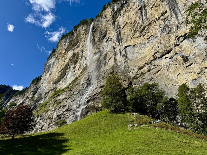
Staubbachfall (Staubach Falls) is one of Lauterbrunnen Valley's most visited waterfalls and for good reason. This 297m (974 feet) waterfall plunges over a massive glacial-carved cliff right in the center of the quaint Alps town of Lauterbrunnen, Switzerland. It's a waterfall that cannot be missed and calls to visitors, tourists, and locals alike to explore it up close.
This guide brings visitors from the closest paid parking lot over to the base of Staubbach Falls and finally ascends to a viewpoint in the cliff side from a trail that's been tunneled through the side of the mountain. A must see for all visitors to the Lauterbrunnen Valley!
For visitors who cannot hike up steep trails, the best view of Staubbach Falls is located along the start of the trail near the Staubbach Falls building. This viewpoint is often filled with tourists, but the trail that leads to the side of the waterfall has a bit less people on it and an uphill challenge through mountainside tunnels.
If you choose to hike the Staubbach Falls trail, you'll be in for an uphill hike. The trail immediately starts heading uphill at a moderate grade before it becomes a bit steeper, following switchbacks up the hillside. Once the switchbacks end, the trail enters a tunnel that bores through the mountainside. On the opposite side of the tunnel is a steep, single-file metal staircase where you might need to wait for other hikers to descend before you make your way up.
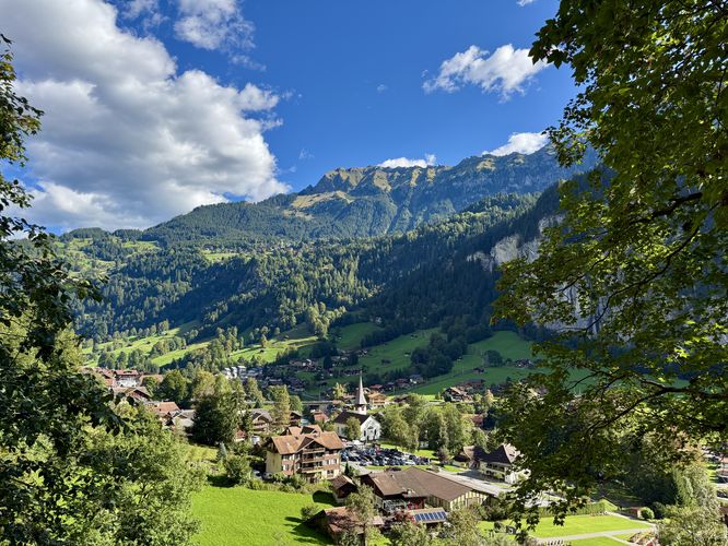
Once you pass the steep staircase, the trail leads through tunnels carved in the mountainside where you'll find views of the quaint village of Lauterbrunnen and the Lauterbrunnen Valley below. The trail dips in and out of viewpoints, but follows an uneven bedrock substrate where you'll often find slippery and wet surfaces. Watch your step and your head!
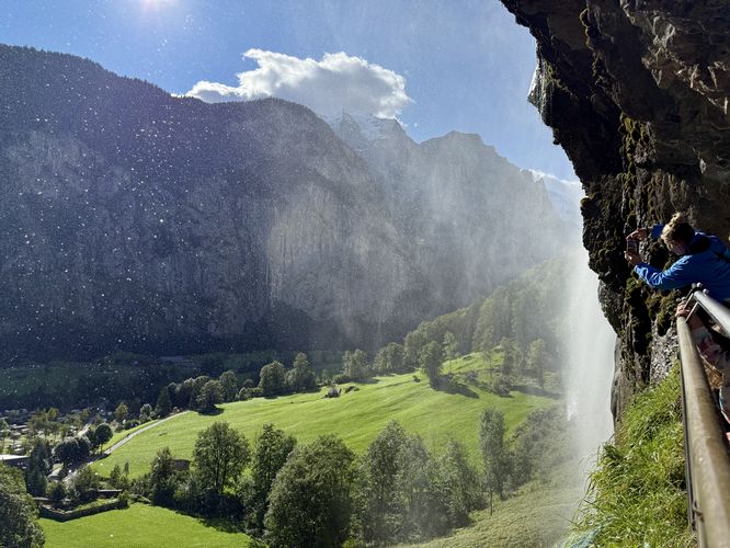
Finally, the trail terminates right next to Staubbach Falls. Here, the view of the waterfall isn't very impressive, but after the steep uphill climb on a hot day it feels good to get a little wet from Staubbach Falls' spray. Take in the views of Staubbach Falls, the birds-eye view of Lauterbrunnen, and the Alps that surround the valley before you hike back down. On your way down the trail be mindful of the rock tunnels — watch your head and your step. Hike the switchbacks back down the hill to reach the trailhead. This short hike finally wraps up after following the route back to parking.
My favorite quote from a tourist on this trail: "Hmm I think it must be raining or something.". I replied: "That's the waterfall".
Slippery surfaces: The mountainside tunnels follow uneven rocky bedrock surfaces that are often wet and slippery from the waterfall's spray. Watch your step.
This guide brings visitors from the closest paid parking lot over to the base of Staubbach Falls and finally ascends to a viewpoint in the cliff side from a trail that's been tunneled through the side of the mountain. A must see for all visitors to the Lauterbrunnen Valley!
Visit Staubbach Falls
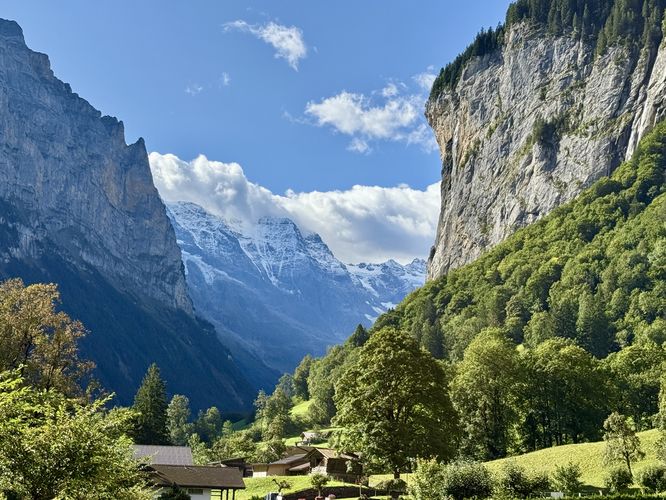
Tourists and visitors to Lauterbrunnen will have a hard time ignoring Staubbach Falls. This massive waterfall can be seen from all around the quaint village of Lauterbrunnen. To explore the waterfall, assuming you arrived by car, the walk starts at Parkplatz Lauterbrunnen Kirche located in the center of town. Views begin right at the parking lot with the towering cliffs and glacier-capped alpine mountains that surround the Lauterbrunnen Valley located overhead. The walk leads south to reach a road where you'll find a building labeled "Staubbachfall" and the 297m waterfall behind it plunging over the cliff.For visitors who cannot hike up steep trails, the best view of Staubbach Falls is located along the start of the trail near the Staubbach Falls building. This viewpoint is often filled with tourists, but the trail that leads to the side of the waterfall has a bit less people on it and an uphill challenge through mountainside tunnels.
If you choose to hike the Staubbach Falls trail, you'll be in for an uphill hike. The trail immediately starts heading uphill at a moderate grade before it becomes a bit steeper, following switchbacks up the hillside. Once the switchbacks end, the trail enters a tunnel that bores through the mountainside. On the opposite side of the tunnel is a steep, single-file metal staircase where you might need to wait for other hikers to descend before you make your way up.
Once you pass the steep staircase, the trail leads through tunnels carved in the mountainside where you'll find views of the quaint village of Lauterbrunnen and the Lauterbrunnen Valley below. The trail dips in and out of viewpoints, but follows an uneven bedrock substrate where you'll often find slippery and wet surfaces. Watch your step and your head!
Finally, the trail terminates right next to Staubbach Falls. Here, the view of the waterfall isn't very impressive, but after the steep uphill climb on a hot day it feels good to get a little wet from Staubbach Falls' spray. Take in the views of Staubbach Falls, the birds-eye view of Lauterbrunnen, and the Alps that surround the valley before you hike back down. On your way down the trail be mindful of the rock tunnels — watch your head and your step. Hike the switchbacks back down the hill to reach the trailhead. This short hike finally wraps up after following the route back to parking.
My favorite quote from a tourist on this trail: "Hmm I think it must be raining or something.". I replied: "That's the waterfall".
Explore the Lauterbrunnen Valley
For more adventures in the Lauterbrunnen Valley, consider exploring the Lauterbrunnen Valley Loop, Trümmelbach Falls, and Mürrenbach Falls.Universal Access
Please note that the walk from the parking area to the trailhead viewpoint of Staubbach Falls should be considered universally-accessible. There are no stairs and the path follows a paved road surface. The trail that leads up into the mountain is not accessible.Pets
Dogs are allowed only if leashed and must be cleaned up after. Dogs may not be allowed on the entire Stuabbach Falls trail. Please see signage at the trailhead for more information.Parking
Visitors will find a large parking lot at the coordinates provided located in the center of Lauterbrunnen at Parkplatz Lauterbrunnen Kirche. The parking lot is a paid parking lot and charges an hourly rate.Warning
Falling rock: This hike leads through tunnels and along cliff sides that were bored out to provide trail access. Falling rock can occur at any time without a warning.Slippery surfaces: The mountainside tunnels follow uneven rocky bedrock surfaces that are often wet and slippery from the waterfall's spray. Watch your step.