Loading...

🌲 WINTER SALE! 50% OFF on Supporter Accounts — now through December 31st. Unlock a full year of exclusive website & app perks for better hikes. Learn More.
A panoramic view of the Matterhorn from Gornergrat (Gorner Ridge) in Zermatt, Switzerland.

The Ultimate Zermatt Guide: Hiking, Dining, and Views of the Matterhorn

Nestled beneath the iconic peak of the Matterhorn, the village of Zermatt is a car-free paradise and the undisputed capital of Swiss alpine hiking. Its dramatic landscape and perfectly preserved charm make it a bucket-list destination for adventurers worldwide. While there are countless trails to explore, we've curated the ultimate short list for your first visit: two unforgettable hikes that deliver truly unbeatable views of the "Mountain of Mountains." This guide also covers the essentials—from parking in Täsch to finding the perfect place to stay and eat—ensuring your Zermatt adventure is seamless and spectacular.

Admin avatar

By Dave Miller

The Hikes: Two Trails with Unbeatable Matterhorn Views

The iconic Matterhorn sits on the horizon with the glimmering waters of the alpine lake Riffelsee in Zermatt, Switzerland.

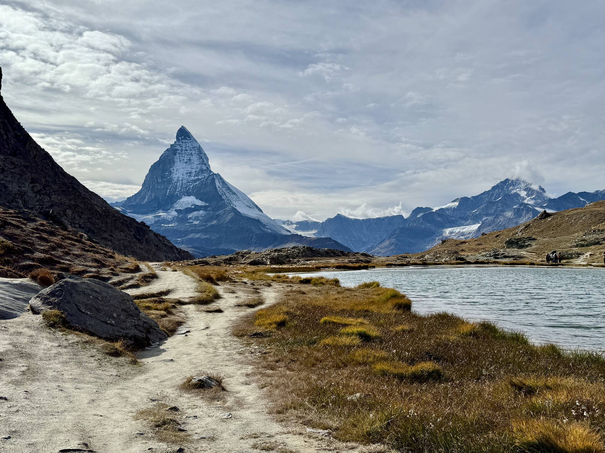
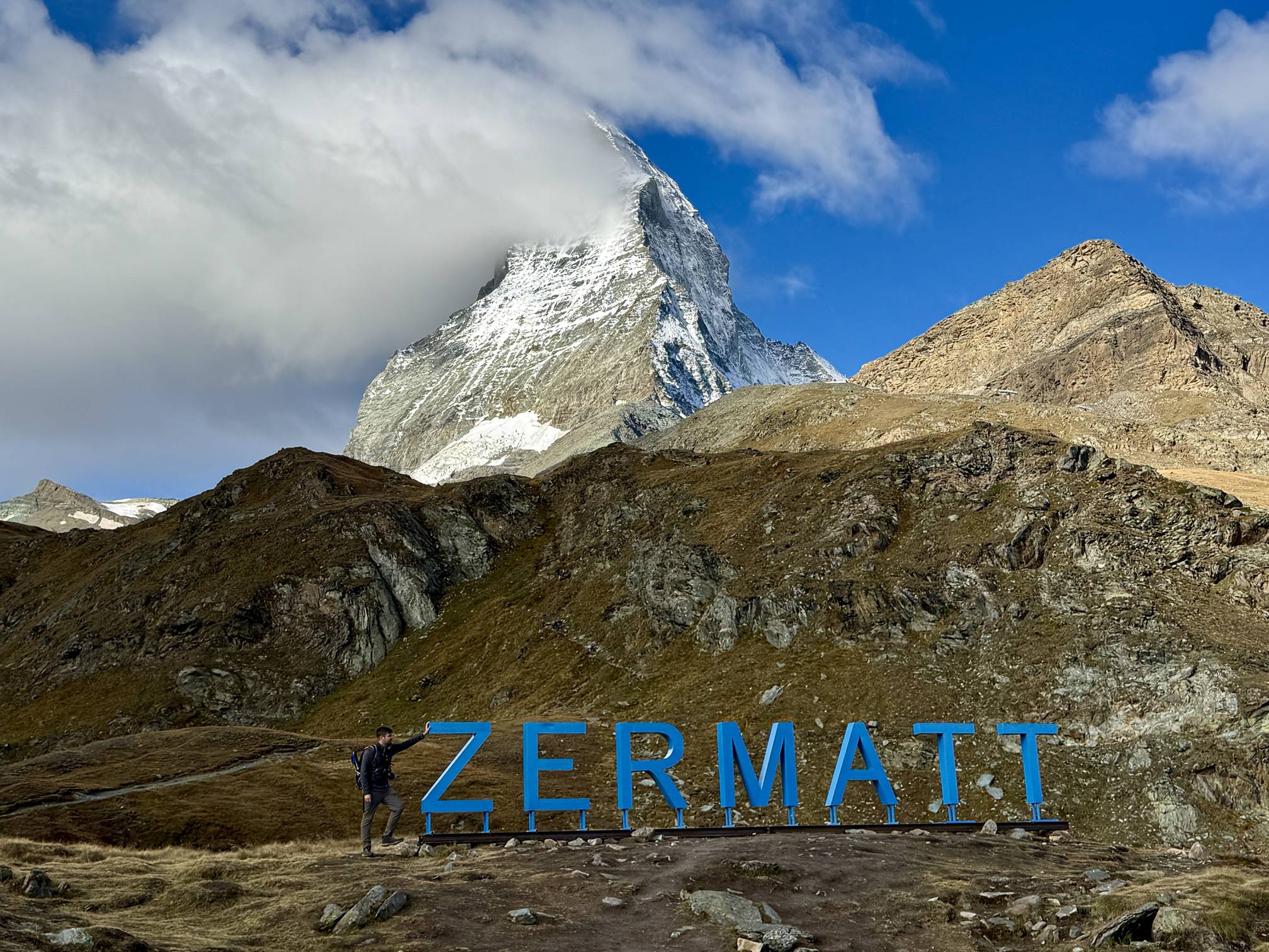
1. The Gornergrat Descent: Glacier Vistas and Matterhorn Reflections

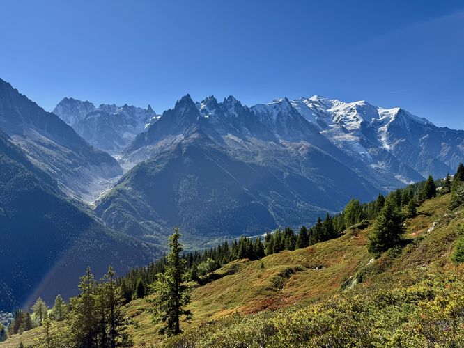
For the ultimate scenic payoff with minimal uphill effort, the descent from Gornergrat to Findelbach station is unparalleled. Begin by riding the historic Gornergrat Bahn to the summit, where you are instantly greeted by the massive Monte Rosa massif and the sprawling Gorner Glacier. This moderate, 10.5 km (6.5 mi) hike is primarily downhill, delivering continuous, jaw-dropping views of the Matterhorn—most famously mirrored in the tranquil waters of the Riffelsee alpine lake. As you descend past Riffelberg and Riffelalp, you are immersed in the exposed alpine landscape, with panoramic scenes high above the Zermatt Valley before finally entering a beautiful larch forest near the end of your journey to the Findelbach station.

View Our Gornergrat Trail Guide (10.5 km)
A hiker stands next to the Zermatt sign located in the exposed alpine zone below the iconic Matterhorn, Switzerland.

2. The Towering Matterhorn: Schwarzsee to Furi Hike

For a stunning perspective of the Matterhorn's sheer face and to gain a new appreciation for the vast Gornergrat region you just explored, the downhill 4.15 km (2.6 mi) hike from Schwarzsee to Furi is a must-see. Accessed via the Matterhorn Express gondola, this route begins with the Matterhorn towering immediately overhead. While the Matterhorn may occasionally duck out of view, this trail provides unparalleled vistas of the sprawling Monte Rosa massif, Gornergrat (Gorner Ridge), and the expansive Grenzgletscher glacier. After soaking in sweeping alpine meadows—and snapping a photo at the popular "Zermatt" sign near the start—the path winds pleasantly down through a beautiful larch forest, ending in the charming, quiet village of Furi for a well-deserved meal before taking the gondola back to Zermatt.

Explore the Matterhorn Schwarzsee to Furi Hike (4.15 km)

🍽️ Fueling Your Adventure: Two Must-Try Zermatt Restaurants

Fondue on a table at Restaurant Ferdinand in Zermatt, Switzerland

1. Ferdinand by CERVO (Zermatt)

For a chic, modern take on a Swiss classic, look no further than Ferdinand by CERVO. Located within the stylish CERVO Mountain Resort, this restaurant offers a warm, contemporary ambiance perfect for unwinding after a day on the trails. Their specialty is a truly delicious, gourmet fondue—made with local ingredients and served with creative pairings—along with other alpine specialties. It’s the ideal spot for a celebratory dinner in the heart of Zermatt, blending upscale style with authentic flavors.

View Menu & Book Table
Rösti with sausages sits on a table at Restaurant Furri, Switzerland.

2. Restaurant Furri (Furi)

Conveniently located near the gondola station where the Schwarzsee hike ends, Restaurant Furri is the quintessential trailside lunch spot. This traditional chalet offers a relaxed, rustic atmosphere where you can refuel with authentic Swiss fare. Their Rösti—a classic potato dish—is highly recommended and the perfect hearty meal to recover from your hike. Pair it with a cold beer or one of their excellent espressos before taking the final gondola ride back to Zermatt.

Check Furi Location & Hours

🏡 Where to Stay: Your Zermatt Home Base

A hotel room at Hotel Aristella swissflair in Zermatt, Switzerland.

Hotel Aristella Swissflair

For a relaxing retreat that balances traditional Swiss charm with modern comfort, the Hotel Aristella Swissflair is an excellent choice. Conveniently located within walking distance of the train stations and village center, this hotel offers spacious, well-appointed rooms. If you are lucky enough to secure one, rooms facing south offer the unparalleled experience of waking up to a magnificent, direct view of the Matterhorn right from your window and balcony. It's the perfect, centrally located base for exploring both the high-alpine trails and the cozy corners of Zermatt village.

Check Availability & Rates

🚂 Getting to Zermatt: Park and Ride from Täsch

A train at the Matterhorn Terminal in Täsch, Switzerland.

Matterhorn Terminal Täsch and the Shuttle Train

Zermatt is famously a car-free village, meaning private vehicles are not permitted beyond the nearby town of Täsch. All drivers must park their car at the Matterhorn Terminal Täsch, which offers thousands of covered parking spots for a daily fee. The terminal is directly connected to the Täsch train station, where you will board the Matterhorn Gotthard Bahn shuttle train. The quick, 12-minute ride delivers you directly to the center of Zermatt. From the Zermatt train station, you can easily walk to your hotel or take one of the village's small, electric taxis to reach your final destination.

Check Train Timetable & Tickets

Ready to Explore Zermatt?

This guide is just your starting point. Use our detailed, full-length trail guides below to plan the logistics, parking, entry fees, and specific routes for your Zermatt adventures.

See All Zermatt Trail Guides

Download the MyHikes® app Today!

Track your hikes, download Trail and Park routes from MyHikes.org to follow offline, or find a new trail to hike on the MyHikes® app!

MyHikes® app with several views including an explore mode to search by location, a trail route while recording a hike on device, and a trail route with POI drawn on the map, set on simple illustrated background. Learn More
🍪 We use cookies to learn about site usage, performance, and to serve map tiles. You may block cookies manually in the browser. By continuing to use MyHikes, you agree. Learn more