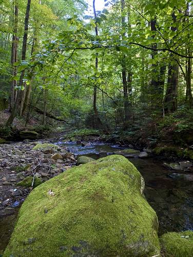
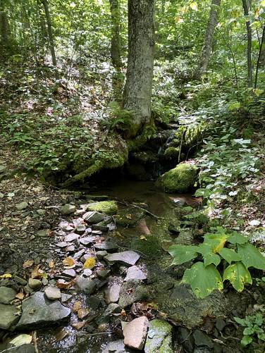
The Green Monster Trail at Tioga State Forest near Wellsboro, Pennsylvania is a strenuous 15.9-mile loop hike that features difficult mountain ascents, creek crossings, small waterfalls, and pipeline "views" with wildflowers during warm months.
Trails
The Green Monster Trail System (marked with yellow blazes) is made-up of several different named trails and forest roads. This hike follows the Green Monster Trail in a counter-clockwise loop and follows these trails in order: Straight Run Trail, Deer Trail, Stone Trail (aka Mt. Nessmuk), Horse Lane Trail, Canada Run Road, Oil Well Hollow Trail, Bark Slide Trail, Matson Road (aka Oak Point Mountain), Lost Trail, Oil Well Hollow Trail, Carpenter Trail, Spoor Hollow Road, Stinger Trail, Plantation Trail, Stone Trail (aka Mt. Nessmuk), Jim Close Trail, Birch Still Trail, Broad Ridge Trail, Left Straight Run Trail, and finally the Straight Run Trail.
Hike Description
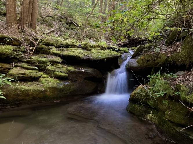
This hike begins at the southern-most parking lot along Straight Run Road - this portion of the trail is the only out-and-back section along the hike. During early Spring, the small waterfalls along Straight Run are worth exploring; however, during the Summer, most are dried up.
Keep Right - Mile 0.55
At mile 0.55, keep right at the fork in the trail. Located just 100-feet up the trail is a right-hand turn that leads up the steep hillside to reach the Deer Trail.
Deer Trail to Stone Trail (Mt. Nessmuk) - Mile 0.6 to 1.8
At mile 0.6, hikers will reach Straight Run Road, crossing, to reach the Deer Trail. The Deer Trail "summits" Mt. Nessmuk, but along the way, hikers will find a difficult, but not horrible ascent of the mountain.
Right Turn at Stone Trail - Mile 1.8
Hikers will take a right-hand turn once at the top of Mt. Nessmuk, along the Stone Trail.
Left Turn at Stone Trail - Mile 2.3
At mile 2.3, which is easy to miss, hikers will take a left-hand turn to stay on the Stone Trail as it begins descending Mt. Nessmuk.
Right Turn to Horse Lane Trail - Mile 3.05
At mile 3.05, hikers will reach a right-hand turn along the Horse Lane Trail. Follow this trail as it leads hikers down to Canada Run Road. Be aware that there's a left-hand turn to stay on the Horse Land Trail at mile 4.05.
Canada Run Road to Oil Well Hollow Trail - Mile 4.33 to 4.4
At mile 4.33, hikers will take a left-hand turn to hike up Canada Run Road for 0.1-miles or less. Take a right-hand turn to begin your hike up Oak Point Mountain via the Oil Well Hollow Trail. Note that at mile 4.45, hikers can filter water at Oil Well Hollow Run.
Right Turn to Bark Slide Trail - Mile 5.4
Around mile 5.4, hikers will reach a very easy-to-miss right-hand turn that leads up the super steep Bark Slide Trail that ascends Oak Point Mountain. This trail is pretty tough to ascend as it has a lot of loose rocks that keep your attention most of the way up in addition to some brutal-steep terrain.
Matson Road aka Oak Point Mountain - Mile 5.8
At mile 5.8, hikers will reach a left-hand turn where the trail will bend into Matson Road, which is a service road that runs the top of Oak Point Mountain. Enjoy this flat walk after the brutal ascent you just hiked up.
Left Turn to Lost Trail - Mile 6.3
At mile 6.3, hikers will reach a left-hand turn to follow the steep and rocky Lost Trail that descends Oak Point Mountain.
Right Turn to Oil Well Hollow Trail - Mile 6.7
Around mile 6.7, hikers will reach the Oil Well Hollow Trail once more - take a right-hand turn here.
Carpenter Trail - Mile 7.65
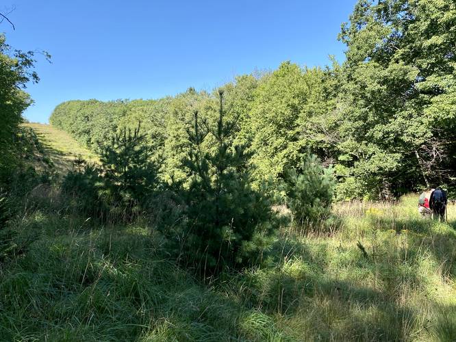
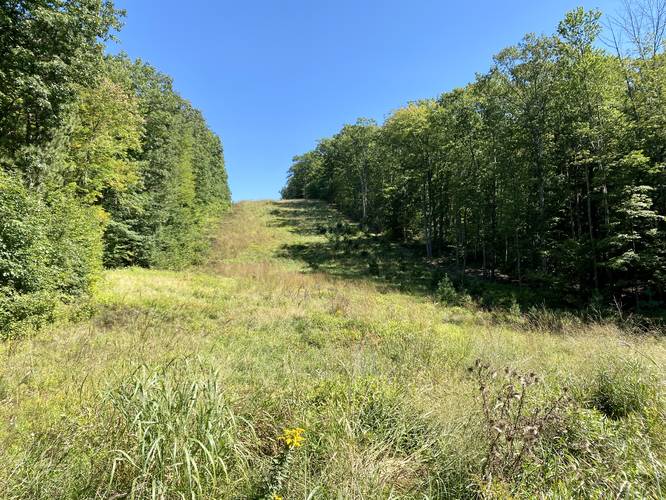
Around mile 7.65, hikers will reach Baldwin Run Road where they'll take a right-hand turn and then an immediate left-hand turn onto the Carpenter Trail. Once on the Carpenter Trail, hikers will be heading down toward Spoor Hollow Road; however, along the way is a pipeline "view" of rolling hills, around mile 7.8.
Left Turn on Spoor Hollow Road - Mile 8.4
At mile 8.4, hikers will reach a left-hand turn onto Spoor Hollow Road. This is the halfway point - for hikers with two vehicles, this is a great spot to setup another car with a cooler for lunch.
Stinger Trail - Mile 8.6 to 8.9
From miles 8.6 to 8.9 hikers will ascent another mountain ridge via the Stinger Trail. This ascent is not easy.
Plantation Trail - Mile 8.9 to 10.2
At mile 8.9, hikers will take a left-hand turn onto the Plantation Trail where they'll hike along an undulating mountain ridge until mile 10.2.
Observatory Trail - Mile 10.2
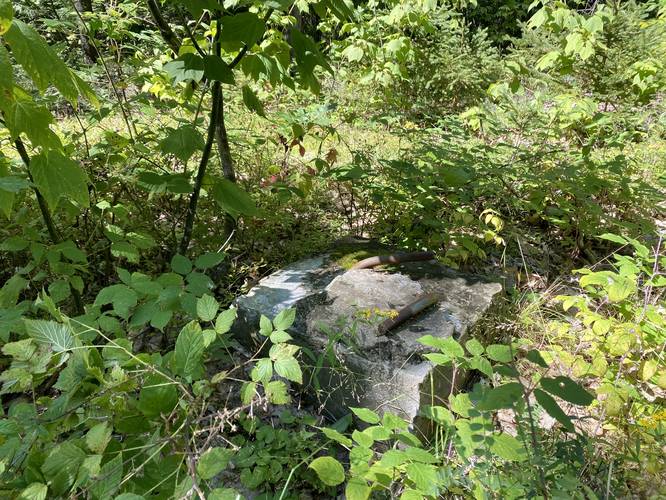
At mile 10.2, hikers will reach a left-hand turn onto the Observatory Trail. Along this trail, located off-trail at mile 10.36, is an old fire tower site (Baldwin Fire Tower) that once stood here. Hikers, if they wish to explore a bit, will find old concrete footings that once held the tower in place.
Stone Trail - Mile 10.5
At mile 10.5, after hiking south from the Observatory Trail and crossing Baldwin Run Road, hikers will once again follow the Stone Trail (aka Mt. Nessmuk) for a short while before taking a right-hand turn onto the Jim Close Trail.
Jim Close Trail - Mile 10.6
Around mile 10.6, hikers will reach the right-hand turn to the Jim Close Trail. Take this turn as it'll lead down the northwestern slopes of Mt. Nessmuk. Keep left along the trail to stay on the path. Along the Jim Close Trail is another pipeline "view" of rolling hills, located around mile 10.95.
Birch Still Trail - Mile 11.8
At mile 11.8, hikers will cross Straight Run Road to follow the Birch Still Trail. This trail is the last ascent on the loop, but is not easy. The trail starts off gradual, even heading up to Broad Ridge, but gets very steep near the end.
Broad Ridge Trail - Mile 13.1
Around mile 13.1, after crossing a service road, hikers will reach the Broad Ridge Trail. Take a left-hand turn here to descend Broad Ridge and to reach Left Straight Run. The Broad Ridge Trail, heading downhill, is extremely steep and rocky.
Left Straight Run Trail - Mile 14
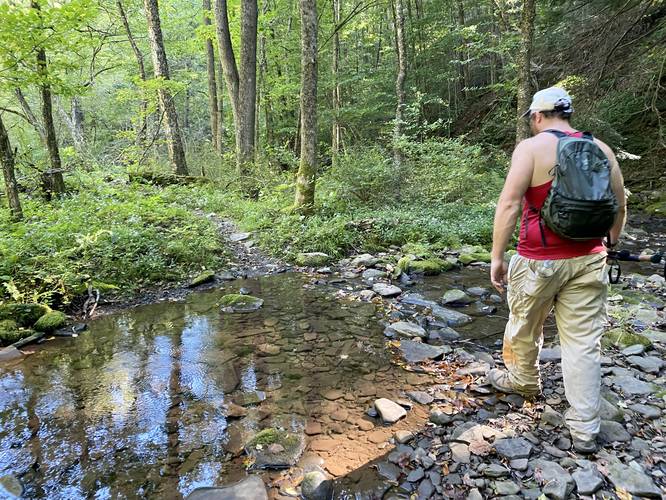
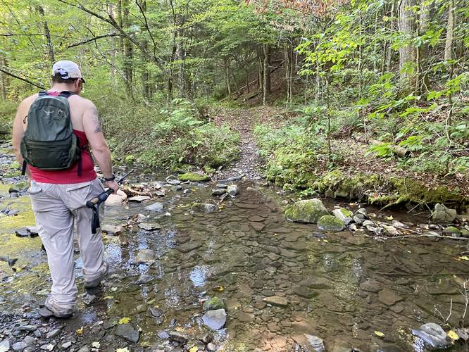
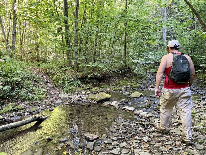
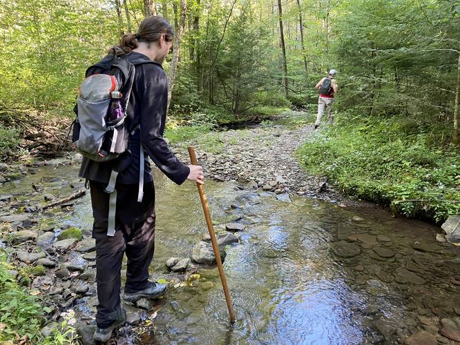
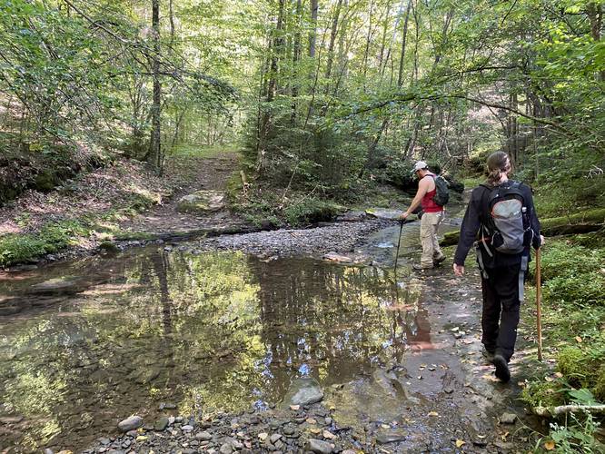
At mile 14, hikers will reach the left-hand turn to Left Straight Run Trail. Here is where the creek crossings begin - worth skipping early into the hike and to save them for last. This is also the trail where hikers will find a small waterfall - Left Straight Run Falls. Left Straight Run Falls is located around mile 15 and cascades down the creek at about 3-feet tall.
Straight Run Trail - Mile 15.3
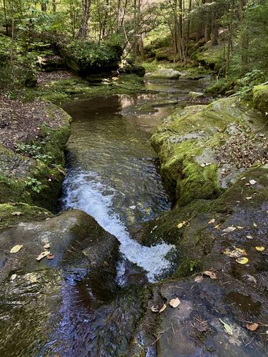
At mile 15.3, hikers will reach the Straight Run Trail as it starts on the opposite side of Straight Run. Just below your feet is the 4-foot tall scenic waterfall known as Straight Run Falls, which is worth stopping at.
Hiking Out - Mile 15.3 to 15.9
Once on the Straight Run Trail, the hike back to parking is the opposite hike that you took on the start of the loop. The trail undulates a bit as it makes its way south to reach the trailhead for the Green Monster Trail / Straight Run Trail at mile 15.9 to end the hike.
Parking
Hikers will find parking at the coordinates provided, the lot is large enough to fit a half-dozen vehicles or more. Note that every road crossing of the Green Monster Trail is a potential parking turnout as well - or has a parking turnout nearby. Hikers can plan long day hikes by leaving two cars along the road - one for parking and one for lunch, if they have a friend to help coordinate. For our hike, we left a car at the junction with Spoor Hollow Road, approximately half-way.
Pets
Dogs are allowed if leashed and should be cleaned up after.
Biking
All of these trails are "red blazed" despite the yellow blazes of the Green Monster - meaning mountain biking is permitted along this trail.
Horse Riding
This is a very popular horse riding trail.
Camping & Backpacking
Camping and backpacking are both permitted along the trail. Please follow all state forest rules and regulations.
Trails
The Green Monster Trail System (marked with yellow blazes) is made-up of several different named trails and forest roads. This hike follows the Green Monster Trail in a counter-clockwise loop and follows these trails in order: Straight Run Trail, Deer Trail, Stone Trail (aka Mt. Nessmuk), Horse Lane Trail, Canada Run Road, Oil Well Hollow Trail, Bark Slide Trail, Matson Road (aka Oak Point Mountain), Lost Trail, Oil Well Hollow Trail, Carpenter Trail, Spoor Hollow Road, Stinger Trail, Plantation Trail, Stone Trail (aka Mt. Nessmuk), Jim Close Trail, Birch Still Trail, Broad Ridge Trail, Left Straight Run Trail, and finally the Straight Run Trail.
Hike Description
This hike begins at the southern-most parking lot along Straight Run Road - this portion of the trail is the only out-and-back section along the hike. During early Spring, the small waterfalls along Straight Run are worth exploring; however, during the Summer, most are dried up.
Keep Right - Mile 0.55
At mile 0.55, keep right at the fork in the trail. Located just 100-feet up the trail is a right-hand turn that leads up the steep hillside to reach the Deer Trail.
Deer Trail to Stone Trail (Mt. Nessmuk) - Mile 0.6 to 1.8
At mile 0.6, hikers will reach Straight Run Road, crossing, to reach the Deer Trail. The Deer Trail "summits" Mt. Nessmuk, but along the way, hikers will find a difficult, but not horrible ascent of the mountain.
Right Turn at Stone Trail - Mile 1.8
Hikers will take a right-hand turn once at the top of Mt. Nessmuk, along the Stone Trail.
Left Turn at Stone Trail - Mile 2.3
At mile 2.3, which is easy to miss, hikers will take a left-hand turn to stay on the Stone Trail as it begins descending Mt. Nessmuk.
Right Turn to Horse Lane Trail - Mile 3.05
At mile 3.05, hikers will reach a right-hand turn along the Horse Lane Trail. Follow this trail as it leads hikers down to Canada Run Road. Be aware that there's a left-hand turn to stay on the Horse Land Trail at mile 4.05.
Canada Run Road to Oil Well Hollow Trail - Mile 4.33 to 4.4
At mile 4.33, hikers will take a left-hand turn to hike up Canada Run Road for 0.1-miles or less. Take a right-hand turn to begin your hike up Oak Point Mountain via the Oil Well Hollow Trail. Note that at mile 4.45, hikers can filter water at Oil Well Hollow Run.
Right Turn to Bark Slide Trail - Mile 5.4
Around mile 5.4, hikers will reach a very easy-to-miss right-hand turn that leads up the super steep Bark Slide Trail that ascends Oak Point Mountain. This trail is pretty tough to ascend as it has a lot of loose rocks that keep your attention most of the way up in addition to some brutal-steep terrain.
Matson Road aka Oak Point Mountain - Mile 5.8
At mile 5.8, hikers will reach a left-hand turn where the trail will bend into Matson Road, which is a service road that runs the top of Oak Point Mountain. Enjoy this flat walk after the brutal ascent you just hiked up.
Left Turn to Lost Trail - Mile 6.3
At mile 6.3, hikers will reach a left-hand turn to follow the steep and rocky Lost Trail that descends Oak Point Mountain.
Right Turn to Oil Well Hollow Trail - Mile 6.7
Around mile 6.7, hikers will reach the Oil Well Hollow Trail once more - take a right-hand turn here.
Carpenter Trail - Mile 7.65
Around mile 7.65, hikers will reach Baldwin Run Road where they'll take a right-hand turn and then an immediate left-hand turn onto the Carpenter Trail. Once on the Carpenter Trail, hikers will be heading down toward Spoor Hollow Road; however, along the way is a pipeline "view" of rolling hills, around mile 7.8.
Left Turn on Spoor Hollow Road - Mile 8.4
At mile 8.4, hikers will reach a left-hand turn onto Spoor Hollow Road. This is the halfway point - for hikers with two vehicles, this is a great spot to setup another car with a cooler for lunch.
Stinger Trail - Mile 8.6 to 8.9
From miles 8.6 to 8.9 hikers will ascent another mountain ridge via the Stinger Trail. This ascent is not easy.
Plantation Trail - Mile 8.9 to 10.2
At mile 8.9, hikers will take a left-hand turn onto the Plantation Trail where they'll hike along an undulating mountain ridge until mile 10.2.
Observatory Trail - Mile 10.2
At mile 10.2, hikers will reach a left-hand turn onto the Observatory Trail. Along this trail, located off-trail at mile 10.36, is an old fire tower site (Baldwin Fire Tower) that once stood here. Hikers, if they wish to explore a bit, will find old concrete footings that once held the tower in place.
Stone Trail - Mile 10.5
At mile 10.5, after hiking south from the Observatory Trail and crossing Baldwin Run Road, hikers will once again follow the Stone Trail (aka Mt. Nessmuk) for a short while before taking a right-hand turn onto the Jim Close Trail.
Jim Close Trail - Mile 10.6
Around mile 10.6, hikers will reach the right-hand turn to the Jim Close Trail. Take this turn as it'll lead down the northwestern slopes of Mt. Nessmuk. Keep left along the trail to stay on the path. Along the Jim Close Trail is another pipeline "view" of rolling hills, located around mile 10.95.
Birch Still Trail - Mile 11.8
At mile 11.8, hikers will cross Straight Run Road to follow the Birch Still Trail. This trail is the last ascent on the loop, but is not easy. The trail starts off gradual, even heading up to Broad Ridge, but gets very steep near the end.
Broad Ridge Trail - Mile 13.1
Around mile 13.1, after crossing a service road, hikers will reach the Broad Ridge Trail. Take a left-hand turn here to descend Broad Ridge and to reach Left Straight Run. The Broad Ridge Trail, heading downhill, is extremely steep and rocky.
Left Straight Run Trail - Mile 14
At mile 14, hikers will reach the left-hand turn to Left Straight Run Trail. Here is where the creek crossings begin - worth skipping early into the hike and to save them for last. This is also the trail where hikers will find a small waterfall - Left Straight Run Falls. Left Straight Run Falls is located around mile 15 and cascades down the creek at about 3-feet tall.
Straight Run Trail - Mile 15.3
At mile 15.3, hikers will reach the Straight Run Trail as it starts on the opposite side of Straight Run. Just below your feet is the 4-foot tall scenic waterfall known as Straight Run Falls, which is worth stopping at.
Hiking Out - Mile 15.3 to 15.9
Once on the Straight Run Trail, the hike back to parking is the opposite hike that you took on the start of the loop. The trail undulates a bit as it makes its way south to reach the trailhead for the Green Monster Trail / Straight Run Trail at mile 15.9 to end the hike.
Parking
Hikers will find parking at the coordinates provided, the lot is large enough to fit a half-dozen vehicles or more. Note that every road crossing of the Green Monster Trail is a potential parking turnout as well - or has a parking turnout nearby. Hikers can plan long day hikes by leaving two cars along the road - one for parking and one for lunch, if they have a friend to help coordinate. For our hike, we left a car at the junction with Spoor Hollow Road, approximately half-way.
Pets
Dogs are allowed if leashed and should be cleaned up after.
Biking
All of these trails are "red blazed" despite the yellow blazes of the Green Monster - meaning mountain biking is permitted along this trail.
Horse Riding
This is a very popular horse riding trail.
Camping & Backpacking
Camping and backpacking are both permitted along the trail. Please follow all state forest rules and regulations.