The Broad Ridge & Waterfalls Hike at Tioga State Forest near Wellsboro, Pennsylvania is a difficult 6.6-mile out-and-back hike that features several short waterfalls and includes difficult mountain terrain for a good workout.
Trails
This hike follows several named trails in the following order: Left Straight Run Trail (yellow blazes), Broad Ridge Trail (yellow blazes), unnamed service road (no blazes). Note that most of this hike follows the Green Monster Trail along Left Straight Run Trail and the Broad Ridge Trail.
Hike Description
This hike begins at the trailhead for the Left Straight Run Trail located at the coordinates provided along Straight Run Road and follows the trail as it leads downhill. Just a couple-hundred feet into the hike, there's a very sharp right-hand turn where hikers will follow the trail as it heads north toward Straight Run creek.
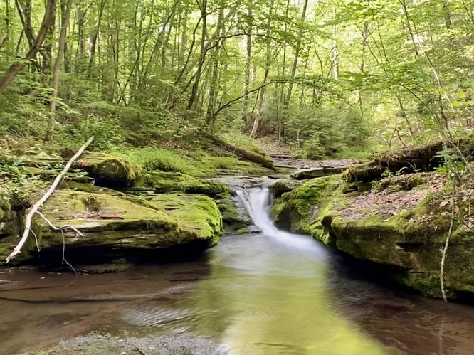
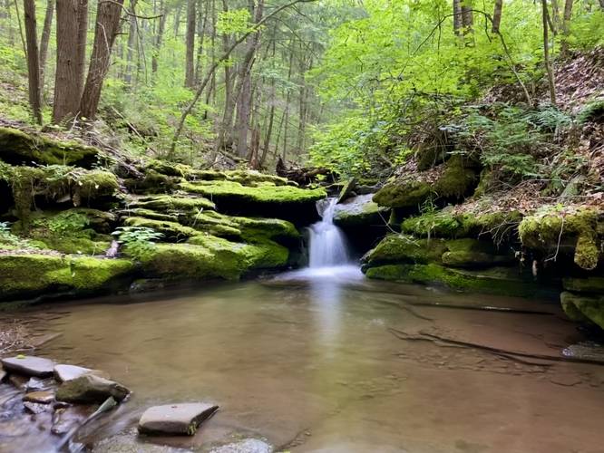
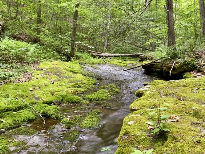
Straight Run Falls - Mile 0.2
At mile 0.2, hikers will reach the 4-foot tall Straight Run Falls which slides down the bedrock in the creek to form a beautiful cascade. This short waterfall is worth stopping at, especially during the late Spring or Summer when the water flows over the moss-covered rocks. After visiting Straight Run Falls, hikers will cross the creek here to continue along the trail.
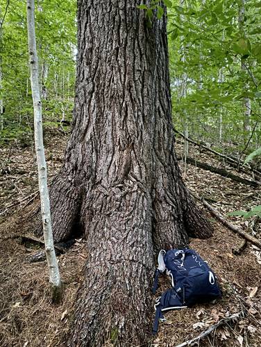
Old-growth White Pine - Mile 0.35
Around mile 0.35, hikers will find an old-growth white pine tree. I did not have string on me to measure the circumference, thus I'm not sure how old the tree is but my "guestimate" places it around 300-years old.
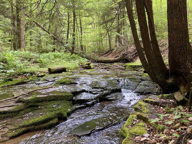
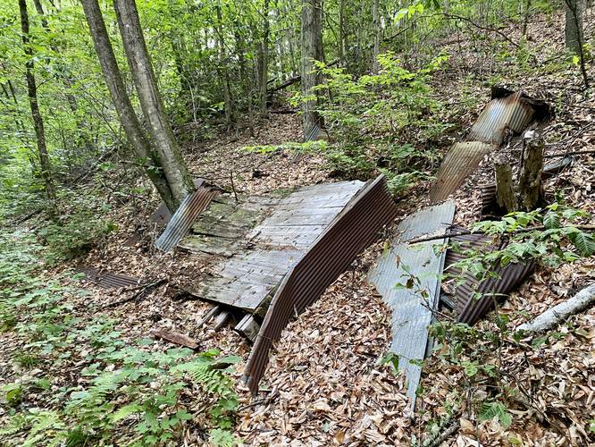
3-Foot Waterfall & Dynamite Shed - Mile 0.55
At mile 0.55, hikers will find a couple different points-of-interest, the first being the old collapsed dynamite shed that sits on the north side of the trail. All that's left are the metal walls that are now lying on the forest floor. In the creek sits a 3-foot waterfall that cascades over some moss-covered rocks and is a nice place to take a quick break to enjoy the flowing water.
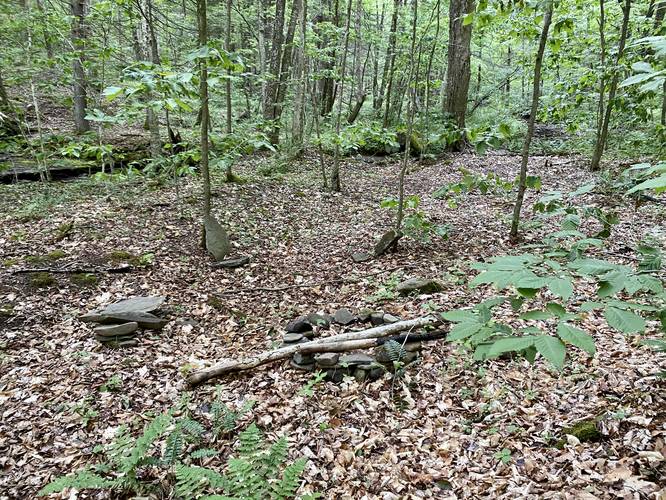
Campsite - Mile 0.57
Just beyond the waterfall and dynamite shed structure sits a campsite fire ring. This old campsite hasn't been used in years (as of June 2023), but looks inviting nonetheless for a tired backpacker.
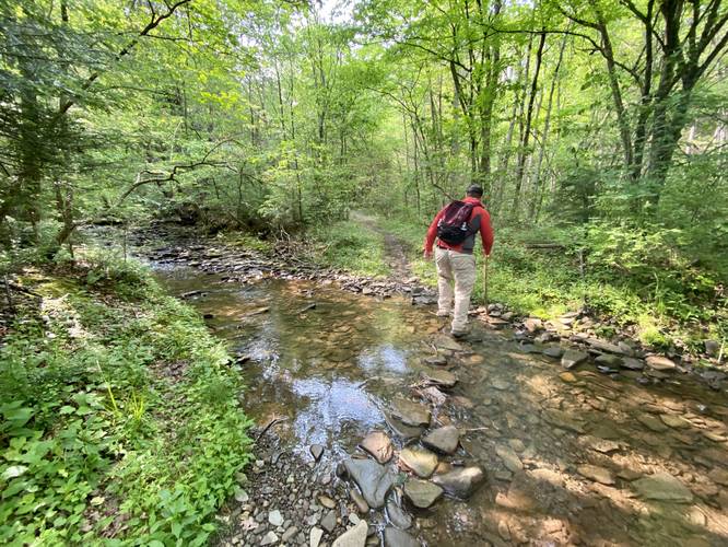
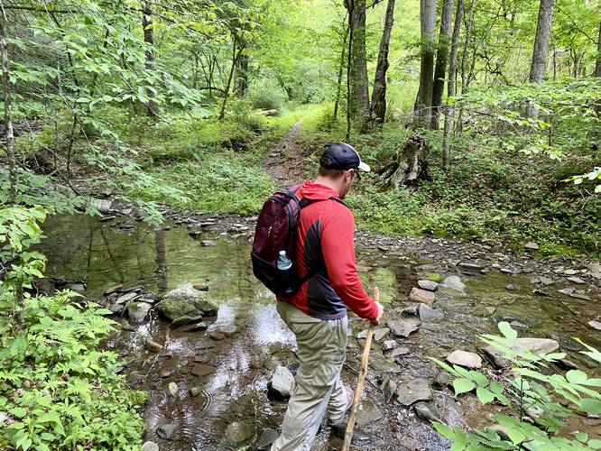
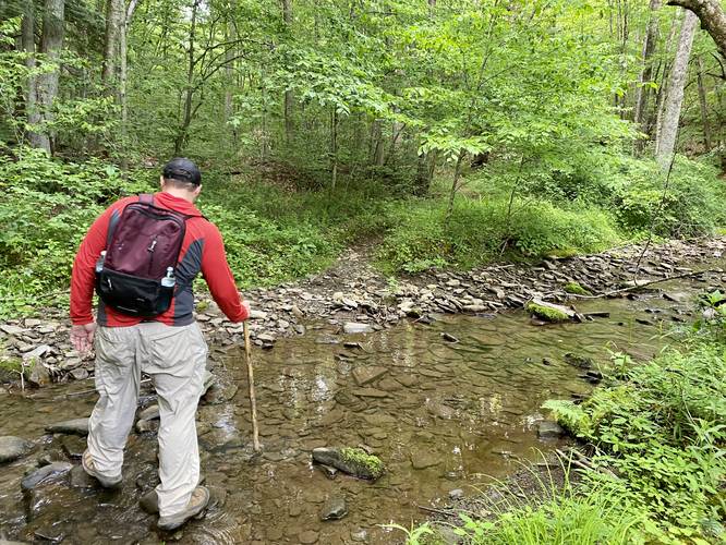
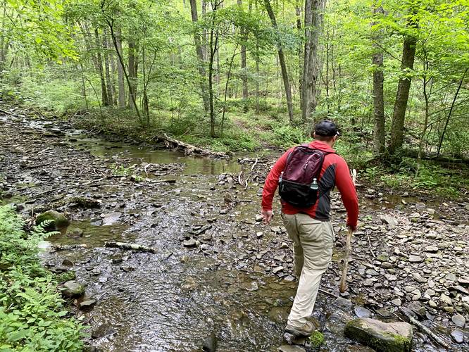
Creek Crossings - Mile 1.2 to 1.35
From miles 1.2 to 1.35 hikers will cross Left Straight Run Creek at least three times. This does not include at least a couple of undocumented creek crossings that hikers will encounter before here.
2-foot Slide Waterfall - Mile 1.55
Around mile 1.55, hikers will reach a short but scenic 2-foot tall slide waterfall.
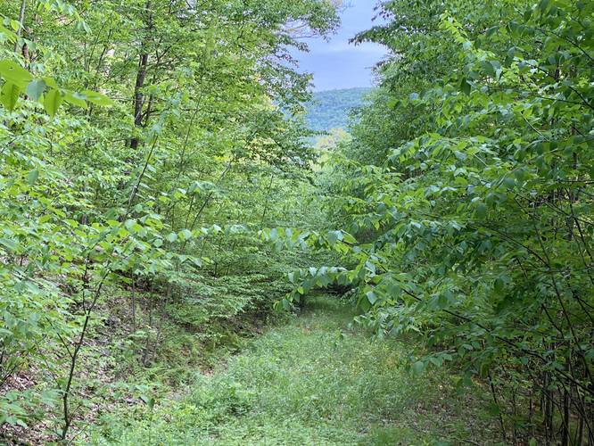
Broad Ridge Trail and Climb - Mile 1.55
At mile 1.55, there's a turn in the trail (adjacent to the waterfall) where hikers will hop on the Broad Ridge Trail. Here the hike becomes very difficult as the the trail shoots straight up the steep slopes of Broad Ridge. Note that the trail does have switchbacks built-in, a countless amount to be exact; however, sometimes the switchbacks just makes the gnarly uphill climb take longer and they often don't "help" much.
Logging Service Road (Right-Hand Turn) - Mile 2.3 to 4.3
At mile 2.3, if you wish to get a lot more exercise than you signed-up for, hikers can take a right-hand turn that leads down Broad Ridge's slopes to reach a dead-end staging area (a place where loggers stage trees for transport). This old service road / log slide trail is not maintained and is overgrown - it does not include any nice views - and is simply an add-on to this hike for exercise and elevation gain. The trail leads downhill, passing countless mountain laurel, to reach the staging area. The staging area has nothing to really see, unless maybe during the winter when no leaves are on the trees, but it's surrounded by a grove of Bigtooth Aspen trees which can be a sight to see during Autumn with their bright yellow leaves.
Hiking Out - Mile 4.3 to 6.6
After returning to the top of Broad Ridge from the service logging road (or if you choose to skip that), the hike back really begins at the top of Broad Ridge from its nice flat terrain. The hike down Broad Ridge is a pain, so take it slow and watch your footing as you traverse over the often rocky path. The creek crossings may get your feet wet (again) on the way out too, but stop to enjoy the waterfalls one last time before leaving this scenic section of Tioga State Forest.
Parking
Hikers will find a small parking turnout at the coordinates provided near the trailhead for the Left Straight Run Trail. The turnout is large enough to fit just a couple of vehicles max.
Pets
Dogs are allowed if leashed and must be cleaned up after.
Camping & Backpacking
Primitive / dispersed / backcountry camping is allowed per state forest rules and regulations. Please follow all state forest rules and regulations if planning to camp.
Warnings
Creek crossings: This hike includes numerous creek crossings - at least 6 or so to reach the Broad Ridge Trail - which would make for about 12 total creek crossings with this hike being out-and-back. During the early Spring, some of these creek crossings look pretty tough (and sometimes deep), especially just upstream from Straight Run Falls.
Steep terrain: The Broad Ridge Trail is very steep and is not easy in either direction. Trekking poles help a ton with the steep terrain and creek crossings.
Timber Rattlesnakes: This area is home to the Timber Rattlesnake which can be found sunning themselves on the trail or hunting along the banks of streams. Be on the lookout and give any rattlesnakes you find plenty of space.
Trails
This hike follows several named trails in the following order: Left Straight Run Trail (yellow blazes), Broad Ridge Trail (yellow blazes), unnamed service road (no blazes). Note that most of this hike follows the Green Monster Trail along Left Straight Run Trail and the Broad Ridge Trail.
Hike Description
This hike begins at the trailhead for the Left Straight Run Trail located at the coordinates provided along Straight Run Road and follows the trail as it leads downhill. Just a couple-hundred feet into the hike, there's a very sharp right-hand turn where hikers will follow the trail as it heads north toward Straight Run creek.
Straight Run Falls - Mile 0.2
At mile 0.2, hikers will reach the 4-foot tall Straight Run Falls which slides down the bedrock in the creek to form a beautiful cascade. This short waterfall is worth stopping at, especially during the late Spring or Summer when the water flows over the moss-covered rocks. After visiting Straight Run Falls, hikers will cross the creek here to continue along the trail.
Old-growth White Pine - Mile 0.35
Around mile 0.35, hikers will find an old-growth white pine tree. I did not have string on me to measure the circumference, thus I'm not sure how old the tree is but my "guestimate" places it around 300-years old.
3-Foot Waterfall & Dynamite Shed - Mile 0.55
At mile 0.55, hikers will find a couple different points-of-interest, the first being the old collapsed dynamite shed that sits on the north side of the trail. All that's left are the metal walls that are now lying on the forest floor. In the creek sits a 3-foot waterfall that cascades over some moss-covered rocks and is a nice place to take a quick break to enjoy the flowing water.
Campsite - Mile 0.57
Just beyond the waterfall and dynamite shed structure sits a campsite fire ring. This old campsite hasn't been used in years (as of June 2023), but looks inviting nonetheless for a tired backpacker.
Creek Crossings - Mile 1.2 to 1.35
From miles 1.2 to 1.35 hikers will cross Left Straight Run Creek at least three times. This does not include at least a couple of undocumented creek crossings that hikers will encounter before here.
2-foot Slide Waterfall - Mile 1.55
Around mile 1.55, hikers will reach a short but scenic 2-foot tall slide waterfall.
Broad Ridge Trail and Climb - Mile 1.55
At mile 1.55, there's a turn in the trail (adjacent to the waterfall) where hikers will hop on the Broad Ridge Trail. Here the hike becomes very difficult as the the trail shoots straight up the steep slopes of Broad Ridge. Note that the trail does have switchbacks built-in, a countless amount to be exact; however, sometimes the switchbacks just makes the gnarly uphill climb take longer and they often don't "help" much.
Logging Service Road (Right-Hand Turn) - Mile 2.3 to 4.3
At mile 2.3, if you wish to get a lot more exercise than you signed-up for, hikers can take a right-hand turn that leads down Broad Ridge's slopes to reach a dead-end staging area (a place where loggers stage trees for transport). This old service road / log slide trail is not maintained and is overgrown - it does not include any nice views - and is simply an add-on to this hike for exercise and elevation gain. The trail leads downhill, passing countless mountain laurel, to reach the staging area. The staging area has nothing to really see, unless maybe during the winter when no leaves are on the trees, but it's surrounded by a grove of Bigtooth Aspen trees which can be a sight to see during Autumn with their bright yellow leaves.
Hiking Out - Mile 4.3 to 6.6
After returning to the top of Broad Ridge from the service logging road (or if you choose to skip that), the hike back really begins at the top of Broad Ridge from its nice flat terrain. The hike down Broad Ridge is a pain, so take it slow and watch your footing as you traverse over the often rocky path. The creek crossings may get your feet wet (again) on the way out too, but stop to enjoy the waterfalls one last time before leaving this scenic section of Tioga State Forest.
Parking
Hikers will find a small parking turnout at the coordinates provided near the trailhead for the Left Straight Run Trail. The turnout is large enough to fit just a couple of vehicles max.
Pets
Dogs are allowed if leashed and must be cleaned up after.
Camping & Backpacking
Primitive / dispersed / backcountry camping is allowed per state forest rules and regulations. Please follow all state forest rules and regulations if planning to camp.
Warnings
Creek crossings: This hike includes numerous creek crossings - at least 6 or so to reach the Broad Ridge Trail - which would make for about 12 total creek crossings with this hike being out-and-back. During the early Spring, some of these creek crossings look pretty tough (and sometimes deep), especially just upstream from Straight Run Falls.
Steep terrain: The Broad Ridge Trail is very steep and is not easy in either direction. Trekking poles help a ton with the steep terrain and creek crossings.
Timber Rattlesnakes: This area is home to the Timber Rattlesnake which can be found sunning themselves on the trail or hunting along the banks of streams. Be on the lookout and give any rattlesnakes you find plenty of space.