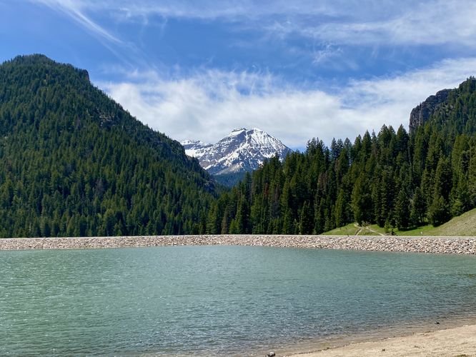
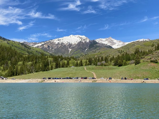
The Tibble Fork Reservoir Loop at Uinta National Forest near Alpine, Utah is a difficult 1.5-mile loop hike that features views of the reservoir's turquoise-tinted waters, Mt. Timpanogos, Box Elder Peak, and White Baldy Mountain.
Difficulty / Dangerous Section
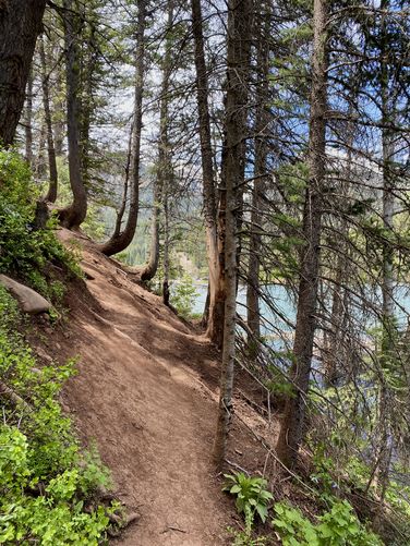
Note that this entire loop should really not be hiked in-full. Turns out there's a reason why the National Forest map does not show the loop completing on the southwest side of this route depicted and that's because the terrain becomes extremely steep and dangerous. This loop begins at the main parking lot and follows the reservoir trail counter-clockwise, heading south first. When you reach mile 0.5, just before the steep terrain begins (it will be fairly obvious), you should really consider turning around. It only gets worse. From mile 0.5 to 0.75 in the route provided, the trail winds its way up a very steep hillside with hard-packed dirt and loose top soil. I ran into two other people on this trail and they also hated it. I personally thought I was going to get seriously injured as my boots were not gripping the terrain well. I thought the trail would get easier, but it only got harder. I found myself clinging on to trees and even small bushes while hoping I didn't accidentally slide 40-feet down the ~50-degree-angled hillside slopes into the trees and reservoir below. I've hiked ~2,800-miles of trails and this 1.5-miles was the worst hike of my life. For your own sanity and safety, do not hike this trail in a loop.
Hike
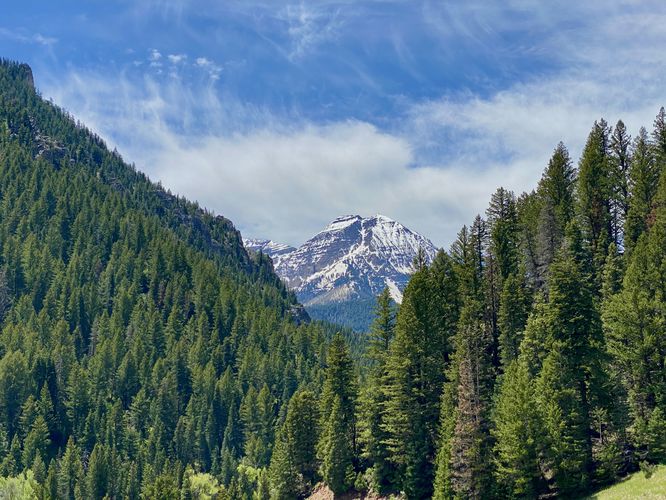
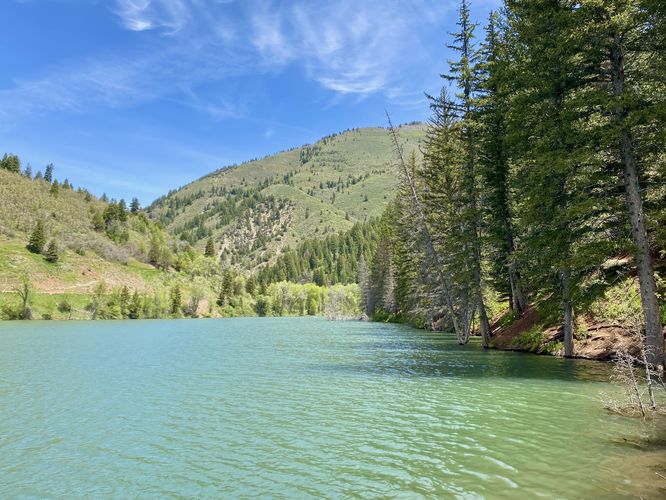
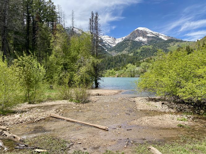
This hike begins at the main parking lot for Tibble Fork Reservoir and follows the paved path as it curves its way southward along the lake. Tibble Fork Reservoir is fairly unique as it's a quick drive from the Provo / American Fork area and provides stunning views of Mt. Timpanogos along with the reservoir's slightly turquoise-tinted waters. The trail offers stunning views and day-use opportunities like picnicking on the south shore. The trail winds its way around the southern tip of the lake where you'll find a water intake pipe that shoots water down and under the trail and road. Behind this is a view of Mt. Timp and the American Fork River as it makes its way down the mountain valley.
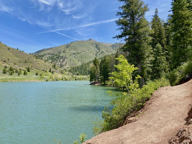
The trail then curves around a steep rocky ledge, which is arguably a bit sketchy if your footwear doesn't grip this soil well. The trail then levels out a bit, passing steep drop-offs into the water below, with more views of the reservoir. Before mile 0.5, you'll find some flat spots along the trail where you can setup a hammock or hang out for the day.
Turn Back - Mile 0.5
At mile 0.5, the trail becomes obviously steeper and more sketchy as it follows a seemingly-washed out hillside. This hillside is dotted with pine trees and shrubs and the trail follows this insanely-sketchy hillside for about 0.2 miles or so. This 1,000-feet of trail is one of the worst I've ever seen. I thought I was going to fall and get seriously injured, so I encourage anyone who reaches the half-mile mark along this trail to turn back before you regret it.
Completing the Loop - Mile 0.5 to 1.5
To document this horrendous solo hike of mine, I decided to continue onward along the loop "trail" as it skirted this very-steep and slippery hillside. I clung on to trees and small bushes to ensure I didn't fall ~40-feet and tumble down the hill into the water below. At one point I sat down and slowly lowered myself closer to the water's edge to ensure safety in case I accidentally fell. The trail finally came down from this hill around mile 0.75 where I was astonished that I didn't need to be rescued. I crossed the Mill Canyon Creek to find the trail was overflowed with water pouring out of the American Fork River. Not knowing if there was a footbridge, I was terrified assuming there might not be as I wasn't sure I could cross the river without trekking poles. Luckily, a footbridge came into sight and I crossed the bridge to reach the main dirt road. I then hiked down the dirt road to reach the parking lot. At the parking lot, I sat and contemplated my existence for several minutes. This was the worst hike of my life.
Nearby Hikes
If you plan to check out this trail, you might want to consider exploring other nearby hikes while in the area like the Silver Lake Trail which leads to an alpine lake, the Silver Lake Flat Reservoir Trail which provides views of the reservoir and surrounding mountains, and the Silver Creek Trail Overlooks which features views of Mt. Timpanogos and the Tibble Fork Reservoir.
Parking
Hikers will find a very large parking lot at the coordinates provided, located at Tibble Fork Reservoir. The lot is large enough to fit many dozens of vehicles.
Pets
Dogs are allowed only if leashed and must be cleaned up after.
Warning
Steep terrain: Please read the abundance of warnings about how stupid it is to try and complete this entire loop hike. The trail follows insanely-steep and dangerous hillside terrain.
Difficulty / Dangerous Section
Note that this entire loop should really not be hiked in-full. Turns out there's a reason why the National Forest map does not show the loop completing on the southwest side of this route depicted and that's because the terrain becomes extremely steep and dangerous. This loop begins at the main parking lot and follows the reservoir trail counter-clockwise, heading south first. When you reach mile 0.5, just before the steep terrain begins (it will be fairly obvious), you should really consider turning around. It only gets worse. From mile 0.5 to 0.75 in the route provided, the trail winds its way up a very steep hillside with hard-packed dirt and loose top soil. I ran into two other people on this trail and they also hated it. I personally thought I was going to get seriously injured as my boots were not gripping the terrain well. I thought the trail would get easier, but it only got harder. I found myself clinging on to trees and even small bushes while hoping I didn't accidentally slide 40-feet down the ~50-degree-angled hillside slopes into the trees and reservoir below. I've hiked ~2,800-miles of trails and this 1.5-miles was the worst hike of my life. For your own sanity and safety, do not hike this trail in a loop.
Hike
This hike begins at the main parking lot for Tibble Fork Reservoir and follows the paved path as it curves its way southward along the lake. Tibble Fork Reservoir is fairly unique as it's a quick drive from the Provo / American Fork area and provides stunning views of Mt. Timpanogos along with the reservoir's slightly turquoise-tinted waters. The trail offers stunning views and day-use opportunities like picnicking on the south shore. The trail winds its way around the southern tip of the lake where you'll find a water intake pipe that shoots water down and under the trail and road. Behind this is a view of Mt. Timp and the American Fork River as it makes its way down the mountain valley.
The trail then curves around a steep rocky ledge, which is arguably a bit sketchy if your footwear doesn't grip this soil well. The trail then levels out a bit, passing steep drop-offs into the water below, with more views of the reservoir. Before mile 0.5, you'll find some flat spots along the trail where you can setup a hammock or hang out for the day.
Turn Back - Mile 0.5
At mile 0.5, the trail becomes obviously steeper and more sketchy as it follows a seemingly-washed out hillside. This hillside is dotted with pine trees and shrubs and the trail follows this insanely-sketchy hillside for about 0.2 miles or so. This 1,000-feet of trail is one of the worst I've ever seen. I thought I was going to fall and get seriously injured, so I encourage anyone who reaches the half-mile mark along this trail to turn back before you regret it.
Completing the Loop - Mile 0.5 to 1.5
To document this horrendous solo hike of mine, I decided to continue onward along the loop "trail" as it skirted this very-steep and slippery hillside. I clung on to trees and small bushes to ensure I didn't fall ~40-feet and tumble down the hill into the water below. At one point I sat down and slowly lowered myself closer to the water's edge to ensure safety in case I accidentally fell. The trail finally came down from this hill around mile 0.75 where I was astonished that I didn't need to be rescued. I crossed the Mill Canyon Creek to find the trail was overflowed with water pouring out of the American Fork River. Not knowing if there was a footbridge, I was terrified assuming there might not be as I wasn't sure I could cross the river without trekking poles. Luckily, a footbridge came into sight and I crossed the bridge to reach the main dirt road. I then hiked down the dirt road to reach the parking lot. At the parking lot, I sat and contemplated my existence for several minutes. This was the worst hike of my life.
Nearby Hikes
If you plan to check out this trail, you might want to consider exploring other nearby hikes while in the area like the Silver Lake Trail which leads to an alpine lake, the Silver Lake Flat Reservoir Trail which provides views of the reservoir and surrounding mountains, and the Silver Creek Trail Overlooks which features views of Mt. Timpanogos and the Tibble Fork Reservoir.
Parking
Hikers will find a very large parking lot at the coordinates provided, located at Tibble Fork Reservoir. The lot is large enough to fit many dozens of vehicles.
Pets
Dogs are allowed only if leashed and must be cleaned up after.
Warning
Steep terrain: Please read the abundance of warnings about how stupid it is to try and complete this entire loop hike. The trail follows insanely-steep and dangerous hillside terrain.