Mt. Timpanogos Trail to Emerald Lake at Uinta National Forest near Provo, Utah is a difficult 10.7-mile out-and-back hike that features stunning views, alpine lakes, and snowfields.
Trails
This hike follows one named trail: Mount Timpanogos Trail (No. 052).
Hike Description
This hike begins at the main parking lot for Mt. Timpanogos located off of Alpine Scenic Highway, at the parking coordinates provided. The Mount Timpanogos Trail (No. 052) begins at this parking lot. Hikers will start off by hiking through an open meadow before reaching the trail registration - it's important to sign-in here just in case something were to happen while on the mountain.
Registration to Lower Timp Falls - Mile 0.1 to 1
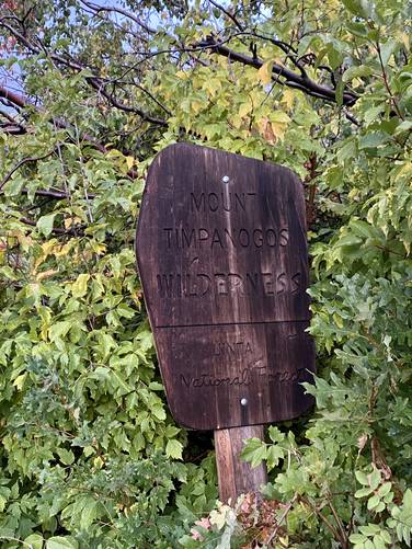
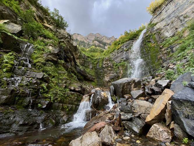
After signing-in, hikers will be on their way into the Mt. Timp valley. Along the way, there will be glimpses of views into the higher valley as you slowly make your way through the trees. During my hike here in late September 2023, there will still a plethora of snowfields scattered in Mt. Timp's hollows and slopes, which made for a really cool entrance to hiking into this valley. At mile 0.38, hikers will reach the "Mount Timpanogos Wilderness" National Forest sign - noting that you've now entered the wilderness. The trail will hit a weird semi-paved area which lasts for about a half-mile, hence the "semi-paved" trail surface for this hike. This semi-paved area is actually a pain to hike on as it makes it fairly easy to roll your ankle. Finally, around mile 1, hikers will reach the ~40-50 foot tall waterfall, Lower Timp Falls, which can be appreciated from the trail. There's a small path that leads to the base of the waterfall, but gets a bit sketchy.
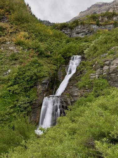
Upper Timp Falls - Mile 1.25
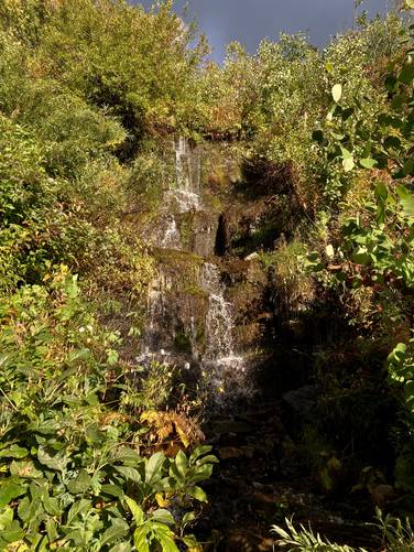
After visiting Lower Timp Falls, hikers will head up a couple of long switchbacks to reach Upper Timpanogos Falls, which cascades as a free-falling waterfall at about 60-feet high. This is a great spot to take a little break and take in the scenery of the waterfall before hiking onward.
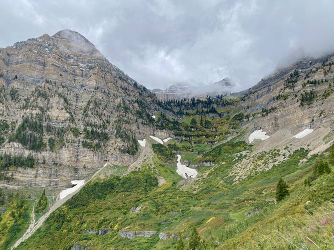
Hiking to Roberts Horn Headwall - Mile 1.25 to 3.2
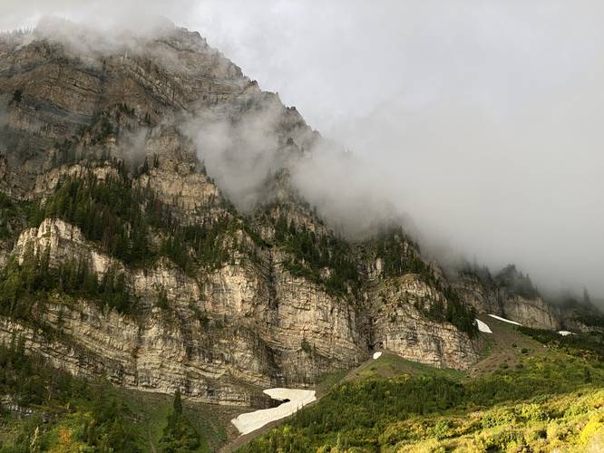
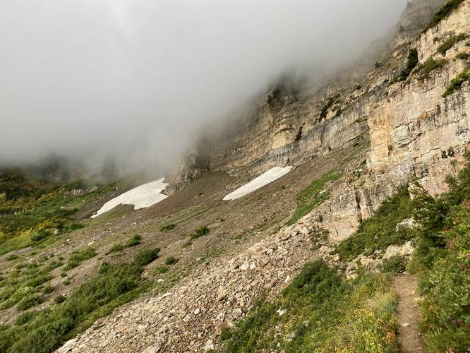
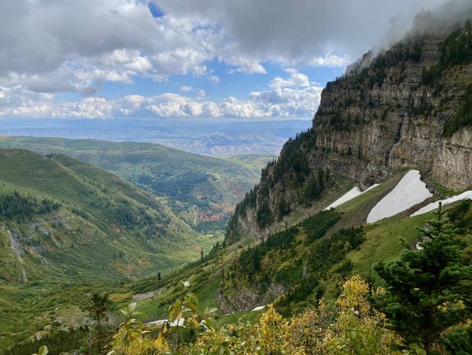
After visiting Upper Timp Falls, hikers will continue on, passing more switchbacks, before following a fairly-straight path that leads below the eastern headwall of Roberts Horn. Along the way, the trail provides stunning views of the Mt. Timpanogos valley, Roberts Horn, and very-likely a scattering of massive snowfields that cling onto the mountain's slopes. The trail will follow underneath Roberts Horn eastern headwall for quite a while - an area where rockfall is common - so continuing to move is smart here. I witnessed a small, but very close-by rockfall while hiking in late September 2023 in this section of the trail which spooked me a bit. Here is also where a lot of the mountainside lupine begin to pop.
Switchbacks Up the Headwall - Mile 3.2 to 4.3
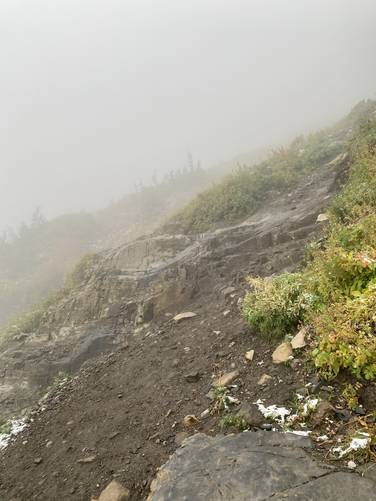
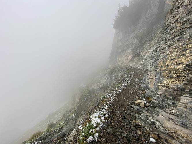
At mile 3.2, hikers will hit the lower section of switchbacks that begin to ascend the eastern headwall of Roberts Horn. This section of the trail is not very difficult, but has a lot of "scary" sections if you're a hiker that's afraid of heights. I, personally, hated this section of the trail but the views were really cool otherwise - so anytime I enjoyed the view, I did so through the screen on my phone to disassociate from the sheer cliff drops. Some noteworthy things along this section are a sketchy scramble with a ~40-foot drop on one side, located around mile 4 and between miles 4 and 4.3 are extremely-steep sheer drop cliffs that the trail follows switchbacks on. Once beyond these switchbacks, the hiking is much easier - both physically and mentally.
Hidden Lake Views - Mile 4.6
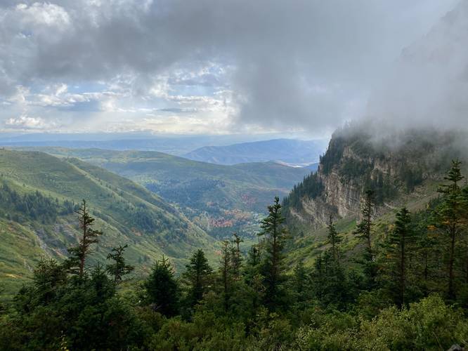
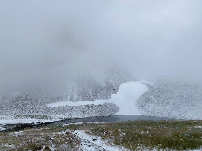
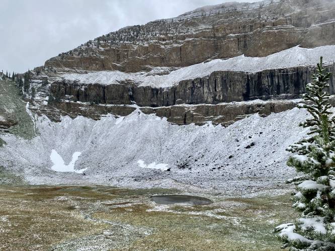
Around mile 4.6, hikers will reach a bend in the trail where, during clear sky days, you'll find the "Hidden Lakes" located off-trail just below another massive cliff headwall. These mountain top alpine lakes are a hidden gem in the landscape, hence their name. The hiking to Emerald Lake from Hidden Lakes lookout is not very difficult, but continues uphill at a moderate grade. Hikers can enjoy the views of the surrounding towering rock walls and wildflowers around them on their way. During my hike here, in late September, I found a "winter wonderland" in this section of the mountain as I hit the mountain on a day of one of its first snowfalls of the season -- this included clouds, snow, and of course snow-covered wildflowers.
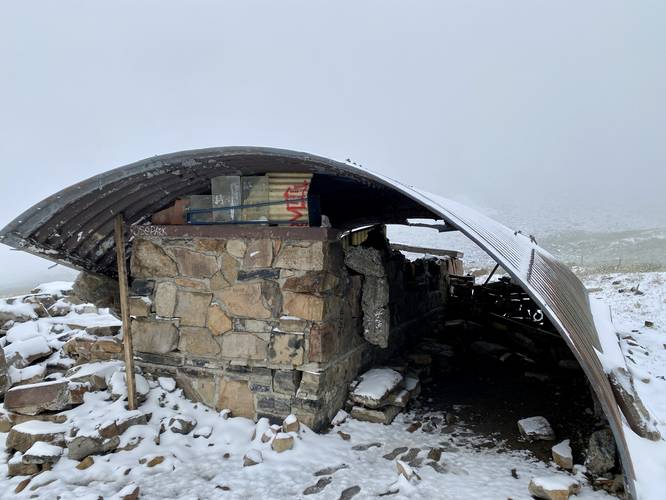
Emerald Lake & Mt. Timp Shelter - Mile 5.34
Finally, at mile 5.34, hikers will reach the Emerald Lake in addition to the Mount Timpanogos shelter. Emerald Lake is an alpine lake that sits below the Mount Timpanogos summit - usually surrounded by beautiful wildflowers in addition to the massive snowfield that sits above its slopes. During my hike here, I got a bit "unlucky" to find the winter wonderland at Emerald Lake instead of the Summer-like wildflower alpine meadows I was hoping for. By the time I reached the Emerald Lake, the temps were around 30F or a bit lower. These temps are not always the case, but can certainly be part of the experience this late in the season. Due to the weather conditions, instead of attempting a summit push, I turned back to parking at Emerald Lake.
Hiking Out - Mile 5.34 to 10.7
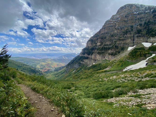
Obviously the hike out is identical but opposite to the hike in, but this time hikers get a different perspective and view on their way out. The downhill hike is significantly easier and faster than the hike up, for more obvious reasons. Roberts Horn headwall is just as sketchy hiking out, but mentally might be easier the second time around. The sketchy scramble is just as sketchy, if not more-so, on the way out, so watch your steps there too. Be sure to take in the views or take a break at Upper or Lower Timp Falls before hitting the parking lot.
Parking
Hikers will find a massive parking lot at the coordinates provided. The lot is large enough to fit many dozen vehicles and tends to fill up fairly early. I hiked this on a Friday and begin before sunrise. I got off the trail around 1:30PM (6.5 hours of hiking) to find the parking lot was 80% full. Weekends are likely much worse.
Pets
Dogs must be leashed and cleaned up after. Note that mountain goats live in these mountains and do and will kill off-leash dogs -- 3 dogs were killed in August 2023 alone. If you plan to bring your dog, it must be under control at all times.
Camping & Backpacking
Dispersed / primitive / backcountry camping is allowed within the Mount Timpanogos Wilderness of Uinta National Forest. Please follow all rules and regulations if planning to camp. Note, the Mt. Timp shelter is located alongside Emerland Lake, approximately 5.6-miles from the parking lot.
Warnings
Cliffs & Steep Terrain: This hike passes a multitude of cliffs with sheer drops that could easily injure or kill. Watch your step especially around areas that require scrambling near cliffs.
Mountain goats: Give any wild animals you find plenty of space.
Rockfalls: This hike follows areas where rockfalls are a common occurrence. In sections of trail prone to rockfall, it's best to keep moving.
Snowfields: While most snowfields do not cross the trail, it's best to stay off of the snowfields for your own safety. Undermining of the snow creates tunnels and caverns that can be hidden from plain view. If the hiker traverses a very-thin layer of snow above one of these tunnels, they could fall 15-20 feet or more to the rocks below, causing serious injury.
Trails
This hike follows one named trail: Mount Timpanogos Trail (No. 052).
Hike Description
This hike begins at the main parking lot for Mt. Timpanogos located off of Alpine Scenic Highway, at the parking coordinates provided. The Mount Timpanogos Trail (No. 052) begins at this parking lot. Hikers will start off by hiking through an open meadow before reaching the trail registration - it's important to sign-in here just in case something were to happen while on the mountain.
Registration to Lower Timp Falls - Mile 0.1 to 1
After signing-in, hikers will be on their way into the Mt. Timp valley. Along the way, there will be glimpses of views into the higher valley as you slowly make your way through the trees. During my hike here in late September 2023, there will still a plethora of snowfields scattered in Mt. Timp's hollows and slopes, which made for a really cool entrance to hiking into this valley. At mile 0.38, hikers will reach the "Mount Timpanogos Wilderness" National Forest sign - noting that you've now entered the wilderness. The trail will hit a weird semi-paved area which lasts for about a half-mile, hence the "semi-paved" trail surface for this hike. This semi-paved area is actually a pain to hike on as it makes it fairly easy to roll your ankle. Finally, around mile 1, hikers will reach the ~40-50 foot tall waterfall, Lower Timp Falls, which can be appreciated from the trail. There's a small path that leads to the base of the waterfall, but gets a bit sketchy.
Upper Timp Falls - Mile 1.25
After visiting Lower Timp Falls, hikers will head up a couple of long switchbacks to reach Upper Timpanogos Falls, which cascades as a free-falling waterfall at about 60-feet high. This is a great spot to take a little break and take in the scenery of the waterfall before hiking onward.
Hiking to Roberts Horn Headwall - Mile 1.25 to 3.2
After visiting Upper Timp Falls, hikers will continue on, passing more switchbacks, before following a fairly-straight path that leads below the eastern headwall of Roberts Horn. Along the way, the trail provides stunning views of the Mt. Timpanogos valley, Roberts Horn, and very-likely a scattering of massive snowfields that cling onto the mountain's slopes. The trail will follow underneath Roberts Horn eastern headwall for quite a while - an area where rockfall is common - so continuing to move is smart here. I witnessed a small, but very close-by rockfall while hiking in late September 2023 in this section of the trail which spooked me a bit. Here is also where a lot of the mountainside lupine begin to pop.
Switchbacks Up the Headwall - Mile 3.2 to 4.3
At mile 3.2, hikers will hit the lower section of switchbacks that begin to ascend the eastern headwall of Roberts Horn. This section of the trail is not very difficult, but has a lot of "scary" sections if you're a hiker that's afraid of heights. I, personally, hated this section of the trail but the views were really cool otherwise - so anytime I enjoyed the view, I did so through the screen on my phone to disassociate from the sheer cliff drops. Some noteworthy things along this section are a sketchy scramble with a ~40-foot drop on one side, located around mile 4 and between miles 4 and 4.3 are extremely-steep sheer drop cliffs that the trail follows switchbacks on. Once beyond these switchbacks, the hiking is much easier - both physically and mentally.
Hidden Lake Views - Mile 4.6
Around mile 4.6, hikers will reach a bend in the trail where, during clear sky days, you'll find the "Hidden Lakes" located off-trail just below another massive cliff headwall. These mountain top alpine lakes are a hidden gem in the landscape, hence their name. The hiking to Emerald Lake from Hidden Lakes lookout is not very difficult, but continues uphill at a moderate grade. Hikers can enjoy the views of the surrounding towering rock walls and wildflowers around them on their way. During my hike here, in late September, I found a "winter wonderland" in this section of the mountain as I hit the mountain on a day of one of its first snowfalls of the season -- this included clouds, snow, and of course snow-covered wildflowers.
Emerald Lake & Mt. Timp Shelter - Mile 5.34
Finally, at mile 5.34, hikers will reach the Emerald Lake in addition to the Mount Timpanogos shelter. Emerald Lake is an alpine lake that sits below the Mount Timpanogos summit - usually surrounded by beautiful wildflowers in addition to the massive snowfield that sits above its slopes. During my hike here, I got a bit "unlucky" to find the winter wonderland at Emerald Lake instead of the Summer-like wildflower alpine meadows I was hoping for. By the time I reached the Emerald Lake, the temps were around 30F or a bit lower. These temps are not always the case, but can certainly be part of the experience this late in the season. Due to the weather conditions, instead of attempting a summit push, I turned back to parking at Emerald Lake.
Hiking Out - Mile 5.34 to 10.7
Obviously the hike out is identical but opposite to the hike in, but this time hikers get a different perspective and view on their way out. The downhill hike is significantly easier and faster than the hike up, for more obvious reasons. Roberts Horn headwall is just as sketchy hiking out, but mentally might be easier the second time around. The sketchy scramble is just as sketchy, if not more-so, on the way out, so watch your steps there too. Be sure to take in the views or take a break at Upper or Lower Timp Falls before hitting the parking lot.
Parking
Hikers will find a massive parking lot at the coordinates provided. The lot is large enough to fit many dozen vehicles and tends to fill up fairly early. I hiked this on a Friday and begin before sunrise. I got off the trail around 1:30PM (6.5 hours of hiking) to find the parking lot was 80% full. Weekends are likely much worse.
Pets
Dogs must be leashed and cleaned up after. Note that mountain goats live in these mountains and do and will kill off-leash dogs -- 3 dogs were killed in August 2023 alone. If you plan to bring your dog, it must be under control at all times.
Camping & Backpacking
Dispersed / primitive / backcountry camping is allowed within the Mount Timpanogos Wilderness of Uinta National Forest. Please follow all rules and regulations if planning to camp. Note, the Mt. Timp shelter is located alongside Emerland Lake, approximately 5.6-miles from the parking lot.
Warnings
Cliffs & Steep Terrain: This hike passes a multitude of cliffs with sheer drops that could easily injure or kill. Watch your step especially around areas that require scrambling near cliffs.
Mountain goats: Give any wild animals you find plenty of space.
Rockfalls: This hike follows areas where rockfalls are a common occurrence. In sections of trail prone to rockfall, it's best to keep moving.
Snowfields: While most snowfields do not cross the trail, it's best to stay off of the snowfields for your own safety. Undermining of the snow creates tunnels and caverns that can be hidden from plain view. If the hiker traverses a very-thin layer of snow above one of these tunnels, they could fall 15-20 feet or more to the rocks below, causing serious injury.