The Silver Lake Trail at Uinta National Forest near Alpine, Utah is a difficult 4.6-mile out-and-back hike that leads to the scenic alpine lake, Silver Lake, and features stunning views of Mt. Timpanogos, the 190-foot tall Silver Creek Falls, and the 30-foot tall Lower Silver Creek Falls.
Hike
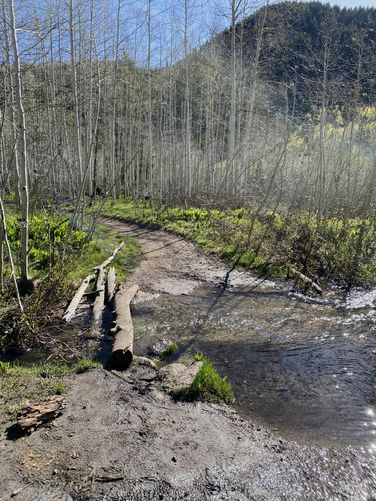
This hike begins at the very end of the rugged dirt road, Silver Lake Flat Road within the Lone Peak Wilderness of the Uinta National Forest. The Silver Lake Trail can be found on the northwest section of the large parking lot where hikers will begin the trek up the eastern slopes of White Baldy mountain. The trail begins a gradual ascent as it leads into an Aspen-filled woods that sits adjacent to Silver Creek as it cascades its way down the mountain. Along this section of the trail, hikers will find opportunities to check out Silver Creek and its small cascading waterfalls (less than 3-feet tall) located just off-trail. If you need to, you can filter water from Silver Creek here. You'll also find a very easy shallow creek crossing around mile 0.45 which is almost not worth noting it was so easy.
After passing the first shallow creek crossing, the trail's elevation grade becomes harder and lasts this way for virtually the rest of the hike. If you haven't acclimated (obviously not a local) to the ~8,000-foot altitude, you might start noticing the hike becomes even more difficult starting here. The trail provides views of White Baldy mountain as you ascend closer and closer to Silver Lake, but the views get a lot better after the 2nd creek crossing.
Silver Creek Crossing - Mile 1
Around mile 1, hikers will reach a real creek crossing with Silver Creek. During my hike here in late May 2024, I found the creek was roaring down the mountain with an abundance of snow melt which looked extra challenging when I was by myself. A group of 2 hikers popped up out of nowhere and walked through the water and over to my side -- they then encouraged me to just got for it as I was thinking about turning back here. The creek's strength was actually not as strong as I expected; however, that may not always be the case especially during snow melt season or after a heavy rain. I made my way across Silver Creek in about knee-deep water and then put my socks and boots back on to continue the hike. Thank you to the two hikers that encouraged me to press onward as the views, waterfalls, and Silver Lake were well-worth crossing in this knee-deep freezing water.
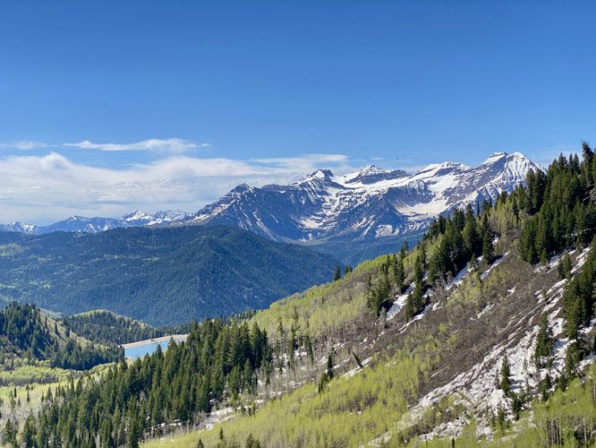
Mt. Timp & American Fork Canyon Views - Mile 1 to 1.6
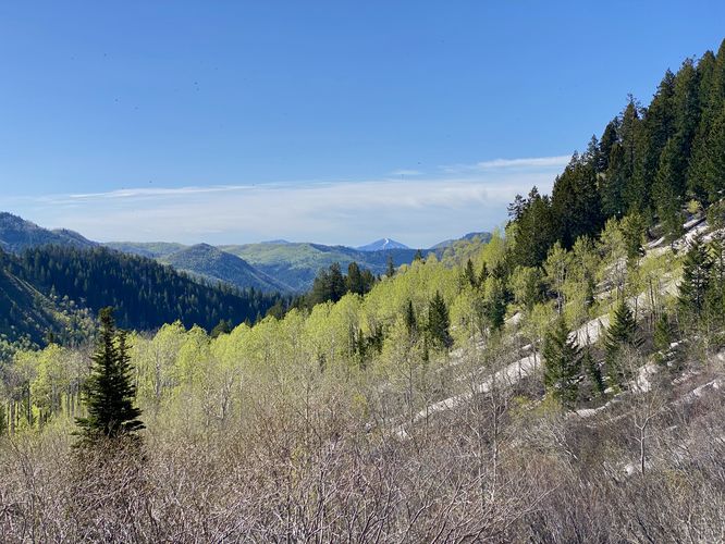
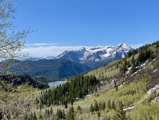
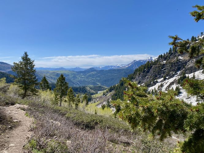
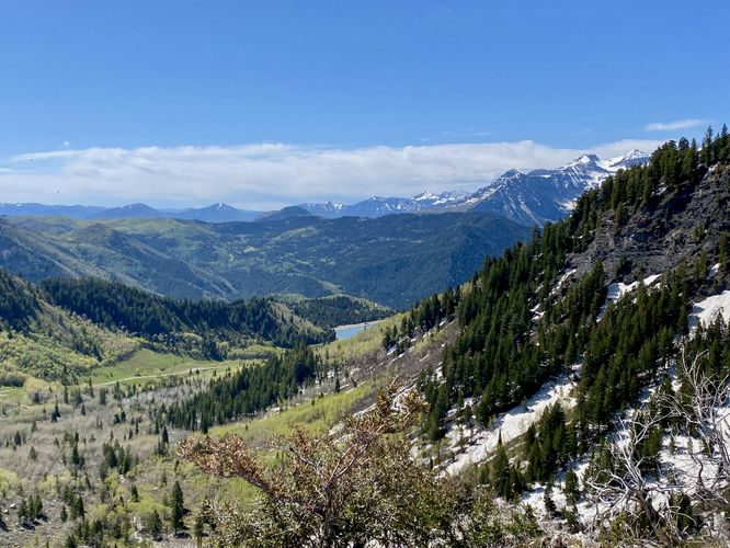
Immediately after crossing Silver Creek's freezing waters, the trail provides hikers with a payout right off the bat. Looking down Silver Creek, you'll find views into the American Fork Canyon and its surrounding mountains along with Mt. Timp and the Silver Lake Flat Reservoir in the background. These views last from the northern side of the creek until about mile 1.6 until you reach Lower Silver Creek Falls (and also, beyond).
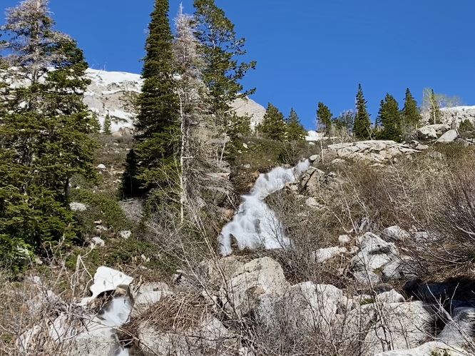
Lower Silver Creek Falls (30-feet tall) - Mile 1.65
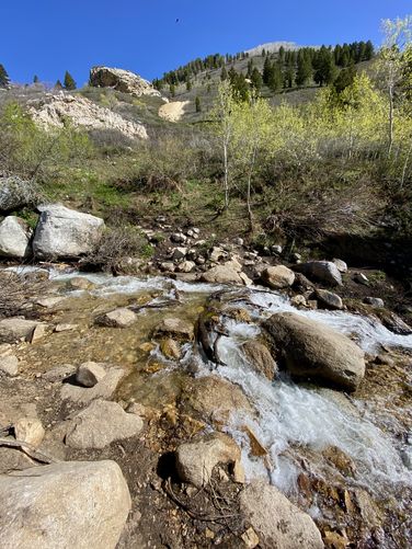
The trail leads up to a waterfall in Silver Creek that cascades down the mountain in two tiers at about 30-feet tall in total. This is just one of two main waterfalls in Silver Creek, hence the name Lower Silver Creek Falls. Hikers will be able to appreciate the waterfall from the trail, downstream, about ~100-feet away.
Views & Maybe an old Mine Shaft - Mile 1.65 to 1.95
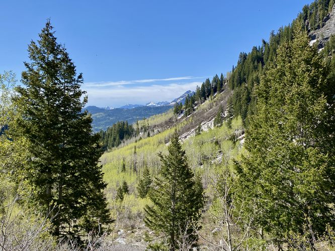
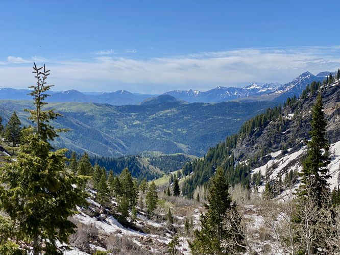
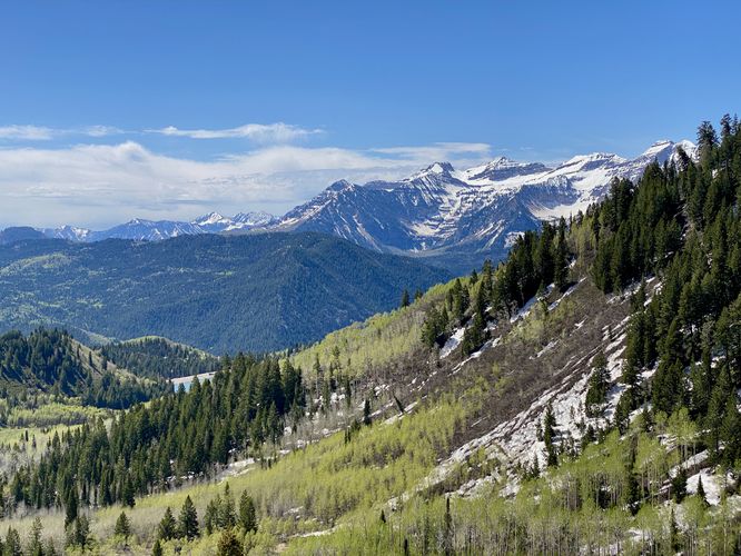
After Lower Silver Creek Falls, the trail continues its ascent toward Silver Lake by passing a plethora of views along the way -- to be fair, most of the trail is wide open at this elevation so you'll have a view for most of the trail with respect to some trees and skinny forests that block it from time to time. You may notice a short out-and-back vista that sits atop a large rock outcropping, located around mile 1.9 in this route. I explored this on my hike out to take photos, but noticed there was a very large hole in the ground with a ton of rocks filling it in -- I could only assume this looked like an old mine shaft, covered up for people's safety, though I could be wrong. You can choose to head off the main path to check this out and the accompanying view if you wish. Regardless, the views into the American Fork Canyon last until mile 1.95 or so before the next point-of-interest, Silver Creek Falls (190-feet tall).
Views of Silver Creek Falls (190-feet tall) - Mile 2
At mile 2, hikers will reach a viewpoint on-trail of Silver Creek Falls which cascades down the steep mountain cliffs that sit on the eastern side of Silver Lake. This waterfall is approximately 190-feet tall as it starts in the outflowing creek from Silver Lake and tumbles its way down the entire mountain. You'll hike a bit closer to the waterfall as the trail ascends switchbacks up to Silver Lake, but the best view is around mile 2 on the hike-in.
Snowfields (Seasonal) to Silver Lake - Mile 2.1 to 2.3
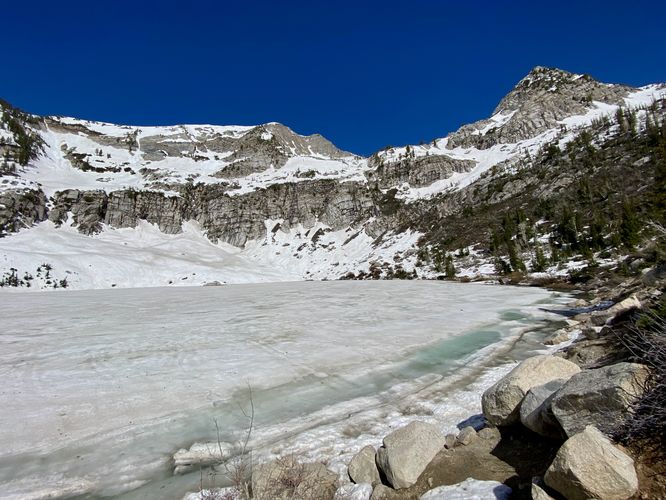
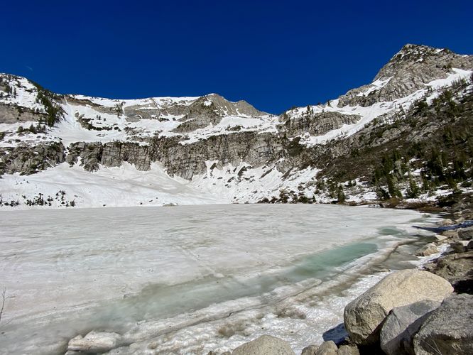
Around mile 2.1, just after taking in the views of Silver Creek Falls, hikers will be just a couple-hundred feet below Silver Lake and only two-tenths of a mile away. Here, during late Spring (or Fall), the trail may be covered in snowfields. These snowfields are fairly easy to traverse but may have undermining in them that goes unnoticed. The trail then hits switchbacks that climb the last ~200-foot ascent up to Silver Lake. The last section of the trail is by far the steepest, which leads hikers to the shore of Silver Lake. Once at the top of the trail, you can hike out to the lake by descending ~10 to 15 feet to the water's edge. Here, you'll find stunning views of Silver Lake and White Baldy mountain hanging overhead. During my hike here in late May 2024, the snowfields spanned almost the entire landscape at Silver Lake, making it virtually impossible to see even with sunglasses on. I took as many photos as I could and enjoyed Silver Lake's frozen surface with its turquoise-tinted water's edge before I hiked out. I also found the views of American Fork Canyon and the surrounding mountains to be stunning from Silver Lake's eastern edge, near where the route ends.
Hiking Back - Mile 2.3 to 4.6
The hike back to parking is fairly straight forward, despite the creek crossing at Silver Creek. The 2nd time you cross Silver Creek, you already know what you're getting into -- assuming it hasn't rained heavily since you first crossed. The water is still freezing. The hike back to parking is generally a bit faster, especially if you can cruise along the trail uninterrupted by the rocks and views that distract you on the way out. Don't forget to take-in the views of the mountains and waterfalls before you leave.
Parking
Hikers will find a large parking lot located at the coordinates provided, at the very end of Silver Lake Flat Road. Note that this road is closed for a very large portion of the year once too much snow and ice have built-up during the Fall. The road is generally open for travel after it's been cleared during late Spring. For more information about seasonal road closures, contact Uinta National Forest. The turnout is large enough to fit less than 5 vehicles as of May 2024. Note that the road to reach this trailhead is a dirt road with ruts and potholes. The road follows some insanely-steep mountain slopes with just barely enough space for two vehicles to pass each other. Just reaching this trailhead might not be for everyone.
Pets
Dogs are allowed only if leashed and should be cleaned up after.
Restrooms
There are restrooms at the trailhead as of May 2024.
Warnings
Elevation sickness: This trail leads hikers up to about 9,000 feet above sea level. Around the 7,000-foot mark above sea level, hikers may start to experience symptoms of elevation sickness including headache, muscle aches, shortness of breath, among other warning signs. In order to avoid elevation sickness it's recommended to ascend to higher elevations and take short walks to acclimate over the course of several days before taking a long or physically-demanding hike. At any time you feel elevation sickness kicking in, that's the time to turn back and head for lower altitude or the parking lot.
Wild animals: While rare, hikers may encounter bears or mountain lion along the trail. Again, this is rare due to the popularity of the trail; however, it's smart to know that these wild animals could be on-trail. Please read-up on how to properly handle a bear or mountain lion encounter before hitting the trails.
Steep terrain: This hike passes several areas where the terrain becomes very steep. Watch your step and always stay away from steep terrain near fast-moving water sources as they pose serious danger to hikers.
Creek crossing: This trail crosses Silver Creek which is often freezing cold in the Spring due to the water source -- snow. The creek can be strong depending on the season, snow melt, or after heavy rainfall. During this hike I crossed the creek in freezing snow melt waters but the creek was not very strong.
Steep snow fields: During late Spring (late May / early June), the trail may still have large patches of snow, called snow fields. These snow fields can slow you down or pose risks like potholing into undermining into deep pockets of air near rocks/boulders. Be mindful of the snowfields and use precautions like ice spikes, trekking poles, or even an ice axe in some cases to ensure your own safety from slipping and falling.
Hike
This hike begins at the very end of the rugged dirt road, Silver Lake Flat Road within the Lone Peak Wilderness of the Uinta National Forest. The Silver Lake Trail can be found on the northwest section of the large parking lot where hikers will begin the trek up the eastern slopes of White Baldy mountain. The trail begins a gradual ascent as it leads into an Aspen-filled woods that sits adjacent to Silver Creek as it cascades its way down the mountain. Along this section of the trail, hikers will find opportunities to check out Silver Creek and its small cascading waterfalls (less than 3-feet tall) located just off-trail. If you need to, you can filter water from Silver Creek here. You'll also find a very easy shallow creek crossing around mile 0.45 which is almost not worth noting it was so easy.
After passing the first shallow creek crossing, the trail's elevation grade becomes harder and lasts this way for virtually the rest of the hike. If you haven't acclimated (obviously not a local) to the ~8,000-foot altitude, you might start noticing the hike becomes even more difficult starting here. The trail provides views of White Baldy mountain as you ascend closer and closer to Silver Lake, but the views get a lot better after the 2nd creek crossing.
Silver Creek Crossing - Mile 1
Around mile 1, hikers will reach a real creek crossing with Silver Creek. During my hike here in late May 2024, I found the creek was roaring down the mountain with an abundance of snow melt which looked extra challenging when I was by myself. A group of 2 hikers popped up out of nowhere and walked through the water and over to my side -- they then encouraged me to just got for it as I was thinking about turning back here. The creek's strength was actually not as strong as I expected; however, that may not always be the case especially during snow melt season or after a heavy rain. I made my way across Silver Creek in about knee-deep water and then put my socks and boots back on to continue the hike. Thank you to the two hikers that encouraged me to press onward as the views, waterfalls, and Silver Lake were well-worth crossing in this knee-deep freezing water.
Mt. Timp & American Fork Canyon Views - Mile 1 to 1.6
Immediately after crossing Silver Creek's freezing waters, the trail provides hikers with a payout right off the bat. Looking down Silver Creek, you'll find views into the American Fork Canyon and its surrounding mountains along with Mt. Timp and the Silver Lake Flat Reservoir in the background. These views last from the northern side of the creek until about mile 1.6 until you reach Lower Silver Creek Falls (and also, beyond).
Lower Silver Creek Falls (30-feet tall) - Mile 1.65
The trail leads up to a waterfall in Silver Creek that cascades down the mountain in two tiers at about 30-feet tall in total. This is just one of two main waterfalls in Silver Creek, hence the name Lower Silver Creek Falls. Hikers will be able to appreciate the waterfall from the trail, downstream, about ~100-feet away.
Views & Maybe an old Mine Shaft - Mile 1.65 to 1.95
After Lower Silver Creek Falls, the trail continues its ascent toward Silver Lake by passing a plethora of views along the way -- to be fair, most of the trail is wide open at this elevation so you'll have a view for most of the trail with respect to some trees and skinny forests that block it from time to time. You may notice a short out-and-back vista that sits atop a large rock outcropping, located around mile 1.9 in this route. I explored this on my hike out to take photos, but noticed there was a very large hole in the ground with a ton of rocks filling it in -- I could only assume this looked like an old mine shaft, covered up for people's safety, though I could be wrong. You can choose to head off the main path to check this out and the accompanying view if you wish. Regardless, the views into the American Fork Canyon last until mile 1.95 or so before the next point-of-interest, Silver Creek Falls (190-feet tall).
Views of Silver Creek Falls (190-feet tall) - Mile 2
At mile 2, hikers will reach a viewpoint on-trail of Silver Creek Falls which cascades down the steep mountain cliffs that sit on the eastern side of Silver Lake. This waterfall is approximately 190-feet tall as it starts in the outflowing creek from Silver Lake and tumbles its way down the entire mountain. You'll hike a bit closer to the waterfall as the trail ascends switchbacks up to Silver Lake, but the best view is around mile 2 on the hike-in.
Snowfields (Seasonal) to Silver Lake - Mile 2.1 to 2.3
Around mile 2.1, just after taking in the views of Silver Creek Falls, hikers will be just a couple-hundred feet below Silver Lake and only two-tenths of a mile away. Here, during late Spring (or Fall), the trail may be covered in snowfields. These snowfields are fairly easy to traverse but may have undermining in them that goes unnoticed. The trail then hits switchbacks that climb the last ~200-foot ascent up to Silver Lake. The last section of the trail is by far the steepest, which leads hikers to the shore of Silver Lake. Once at the top of the trail, you can hike out to the lake by descending ~10 to 15 feet to the water's edge. Here, you'll find stunning views of Silver Lake and White Baldy mountain hanging overhead. During my hike here in late May 2024, the snowfields spanned almost the entire landscape at Silver Lake, making it virtually impossible to see even with sunglasses on. I took as many photos as I could and enjoyed Silver Lake's frozen surface with its turquoise-tinted water's edge before I hiked out. I also found the views of American Fork Canyon and the surrounding mountains to be stunning from Silver Lake's eastern edge, near where the route ends.
Hiking Back - Mile 2.3 to 4.6
The hike back to parking is fairly straight forward, despite the creek crossing at Silver Creek. The 2nd time you cross Silver Creek, you already know what you're getting into -- assuming it hasn't rained heavily since you first crossed. The water is still freezing. The hike back to parking is generally a bit faster, especially if you can cruise along the trail uninterrupted by the rocks and views that distract you on the way out. Don't forget to take-in the views of the mountains and waterfalls before you leave.
Parking
Hikers will find a large parking lot located at the coordinates provided, at the very end of Silver Lake Flat Road. Note that this road is closed for a very large portion of the year once too much snow and ice have built-up during the Fall. The road is generally open for travel after it's been cleared during late Spring. For more information about seasonal road closures, contact Uinta National Forest. The turnout is large enough to fit less than 5 vehicles as of May 2024. Note that the road to reach this trailhead is a dirt road with ruts and potholes. The road follows some insanely-steep mountain slopes with just barely enough space for two vehicles to pass each other. Just reaching this trailhead might not be for everyone.
Pets
Dogs are allowed only if leashed and should be cleaned up after.
Restrooms
There are restrooms at the trailhead as of May 2024.
Warnings
Elevation sickness: This trail leads hikers up to about 9,000 feet above sea level. Around the 7,000-foot mark above sea level, hikers may start to experience symptoms of elevation sickness including headache, muscle aches, shortness of breath, among other warning signs. In order to avoid elevation sickness it's recommended to ascend to higher elevations and take short walks to acclimate over the course of several days before taking a long or physically-demanding hike. At any time you feel elevation sickness kicking in, that's the time to turn back and head for lower altitude or the parking lot.
Wild animals: While rare, hikers may encounter bears or mountain lion along the trail. Again, this is rare due to the popularity of the trail; however, it's smart to know that these wild animals could be on-trail. Please read-up on how to properly handle a bear or mountain lion encounter before hitting the trails.
Steep terrain: This hike passes several areas where the terrain becomes very steep. Watch your step and always stay away from steep terrain near fast-moving water sources as they pose serious danger to hikers.
Creek crossing: This trail crosses Silver Creek which is often freezing cold in the Spring due to the water source -- snow. The creek can be strong depending on the season, snow melt, or after heavy rainfall. During this hike I crossed the creek in freezing snow melt waters but the creek was not very strong.
Steep snow fields: During late Spring (late May / early June), the trail may still have large patches of snow, called snow fields. These snow fields can slow you down or pose risks like potholing into undermining into deep pockets of air near rocks/boulders. Be mindful of the snowfields and use precautions like ice spikes, trekking poles, or even an ice axe in some cases to ensure your own safety from slipping and falling.