Loading...

WINTER SALE! 50% OFF Supporter Accounts — now through January 31st. Learn More.

Passage du Montenvers

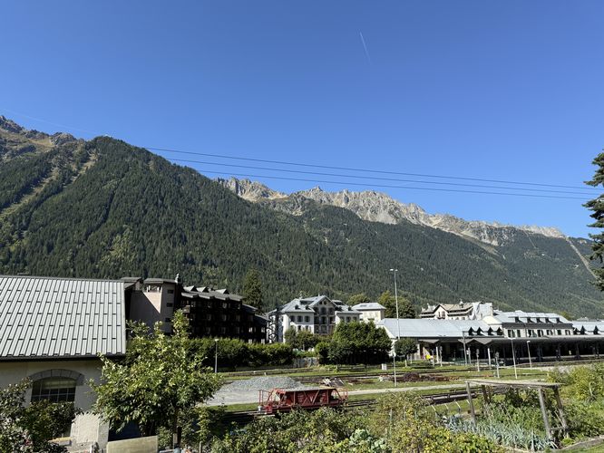
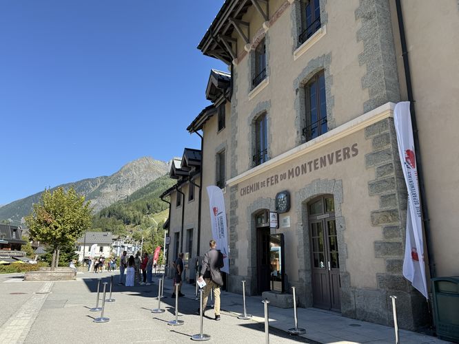
The Passage du Montenvers is a short, easy 0.3 km (0.2 mile) one-way trail located in downtown Chamonix, France. This short path serves as the primary pedestrian connection between Rue Hellbronner and the historic Montenvers train station (Gare du Montenvers-Mer de Glace).

This trail is an crucial part of the logistics for day hikers exploring the Mont Blanc massif. Specifically, it's often used by hikers completing popular one-way routes like the Grand Balcon Nord or other high-altitude treks.

The Passage du Montenvers provides the shortest walking route in town for those who need to connect between the Aiguille du Midi cable car station and the Montenvers train station (Mer de Glace). If you planned your shuttle or parked near either terminus, this easy path, combined with public roads, allows for a quick descent or return to your vehicle after a long day of Alpine trekking.

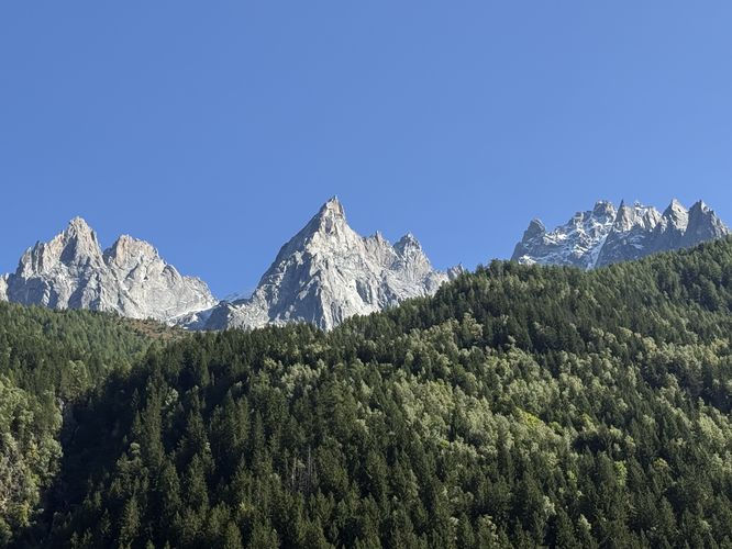
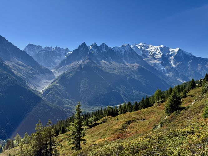
Despite its short length, the path offers quintessential Chamonix viewpoints. As you walk alongside the Montenvers tracks, visitors are treated to unforgettable views of the Mont Blanc Massif towering to the south, featuring jagged peaks like the Aiguille du Midi. Looking north, you'll see the distinct, exposed, red-tinted rock of the Aiguilles Rouges (Red Needles) massif.

The trail conveniently ends (or begins) at the Montenvers train station, the gateway to the famous Mer de Glace glacier and the starting/end point for the Montenvers cogwheel train ride to Chamonix.

Beyond the Passage: Discover More Chamonix Valley Hikes

Ready to trade this short path for an all-day Alpine adventure? The Chamonix Valley offers a trail for every ability, and we have guides for the best of them. Whether you seek the jaw-dropping glacial vistas of the Grand Balcon Nord, the stunning Mont Blanc views from the opposite-side Grand Balcon Sud, a refreshing, easy walk to the Cascade du Dard waterfall, or a trip through history at the scenic Lac Sinclair Ruins, let our detailed guides help you plan your next unforgettable hike in Chamonix.

Parking

Visitors to Mer de Glace or hikers on the Grand Balcon Nord trail will find parking nearby, located on the north side of D 1506 (Rte Blanche) at the coordinates provided. There are two paid parking lots that charge by the hour.

Pets

Dogs are allowed on this trail if leashed and cleaned up after.
Explore 5 trails near Chamonix-Mont-Blanc, France

Know Before You Go

  • The 0.3km trail is an essential pedestrian link for hikers in Chamonix, specifically connecting the Aiguille du Midi cable car station area (Rue Hellbronner) with the Montenvers train station (Mer de Glace), simplifying logistics for one-way hikes like the Grand Balcon Nord.
  • Despite its short length, the path offers immediate and stunning panoramic views of both the iconic Mont Blanc Massif (south) and the jagged, red-hued Aiguilles Rouges (north).
  • The trail is an easy walk primarily used for public access through town, running alongside the train tracks, and is the key final stretch for those needing to return to nearby paid parking near the Montenvers station.
Interactive topographic map for Passage du Montenvers located in Chamonix-Mont-Blanc, France. Click the "View Map" button to load GPS coordinates and trail markers.
Get directions
Distance
0.3 km
Difficulty
Easy
Type
One-Way
Est. Time
6 min
Elev. Gain
2m
Rating
3.0
Added
September 18, 2025
Updated
November 09, 2025
Loading...
Total Change
2m
Ascent
2m
Descent
2m
Loading...

Download the GPX Data for Offline Use

Supporters get exclusive access to download trail routes to the MyHikes app for offline use. Stay prepared on your adventure, even without an internet connection! Become a Supporter today to unlock this feature and hike with confidence.

Download Passage du Montenvers GPX Data to the MyHikes Mobile App

Features

Vista / Lookout Point
Dogs
Biking

Points of interest

  1. Parking

    45.922954, 6.876734
  2. Main Trailhead

    45.921121, 6.872956
  3. View of Mont Blanc massif peaks

    45.92125, 6.873239
    View of Mont Blanc massif peaks
  4. View of Chamonix and Aiguilles Routes (Red Needles) massif in the background

    45.921494, 6.873569
    View of Chamonix and Aiguilles Routes (Red Needles) massif in the background

Safety information

For your own safety: plan ahead, let someone know where you'll be, and hike at your own risk.

Availability

All seasons

Surface type

Dirt

Trip Reports (Reviews)

Rated 3.0 out of 5 based on 1 rating.

Ready to help fellow hikers? Add a trip report to share your experience and provide valuable insights for other hikers!

0.2 miles / 0.3 km
September 18, 2025
Hiking
No community routes found. To add your own hike as a Community Route for this Trail guide, leave a Trip Report with an attached GPX file.

Popular categories

Scenic mountain view representing vista trails
Vista trails
Scenic gorge of cascades representing waterfall trails
Waterfall hikes
Rugged mountain terrain representing summit trails
Summit trails
Scenic mountain view representing dog-friendly trails
Dog-friendly
Scenic campsite with a view representing camping trails
Camping trails
Appalachian Trail logo representing A.T. hikes
A.T. hikes

You May Also Like

🍪 We use cookies to learn about site usage and to serve map tiles. You may block cookies manually in the browser. By continuing you agree. Learn more