Loading...

🎁 Holiday Gifts Alert! Get 30% off the artist's markup on all landscape prints with code HXJBJU to support MyHikes! Browse prints.

Lac Sinclair Ruins Loop

Directions
Map
Pictures
Send to App
Distance:
1.3 km / 0.8 Miles
Type:
Loop
Difficulty:
Easy
Time to Hike:
~24 minutes
Features:
Surface Type:
Dirt
Town:
Chamonix-Mont-Blanc, France
Get Directions:
45.914956, 6.848144
Added:
September 19, 2025
Updated:
November 09, 2025
Copy Trail Link Hiking this trail? Send a friend or family member a link to this trail guide for your own safety. Hike at your own risk (disclaimer)
Loading...
Loading...
17m

Total Change
19m

Ascent
19m

Descent

Download the Trail Route for Offline Use

Supporters get exclusive access to download trail routes to the MyHikes app for offline use. Stay prepared on your adventure, even without an internet connection! Become a Supporter today to unlock this feature and hike with confidence.

Send to App

Key Takeaways

  • This is a gentle 1.3km (0.8 mile) loop walk perfect for all skill levels, starting right next to the Les Gaillands Rock Climbing area in Chamonix, France.
  • Discover the picturesque Lac Sinclair Ruins (stone walls with an arched window) and capture breathtaking views of the Mont Blanc massif and Aiguille du Midi.
  • Don't miss the stunning mirrored views of Mont Blanc on the water while circling Lac des Gaillands, making this one of the best easy photo spots in the Chamonix Valley.

Lac Sinclair Ruins Loop

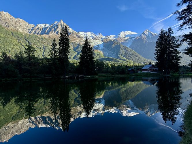
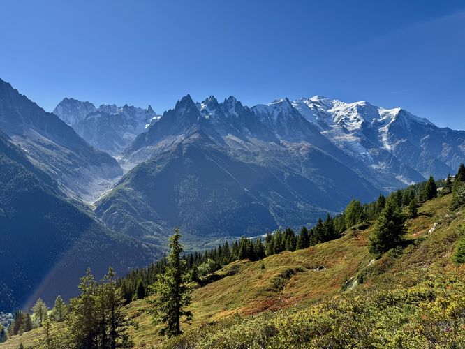
Located in the heart of Chamonix, France, this easy Lac Sinclair Ruins walk is perfect for all visitors. The short, 1.3km (0.8 mile) loop trail guides you to the secluded stone ruins of Lac Sinclair and offers breathtaking views of the Mont Blanc massif and Aiguille du Midi. This scenic loop also takes you past the well-known Les Gaillands Rock Climbing area and circles Lac des Gaillands, featuring stunning, reflective views of Mont Blanc over the water.

Exploring the Lac Sinclair Ruins

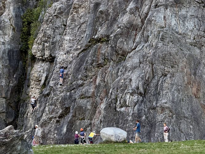
This short walk begins on the north side of Rte des Gaillands in Chamonix where visitors will first find the climbing walls of the Les Gaillands Rock Climbing area, located next to the parking lot. If you're an avid rock climber, the Les Gaillands Rock Climbing area is the perfect place to enjoy a climb with views of Mont Blanc, without having to travel far from Chamonix's downtown.

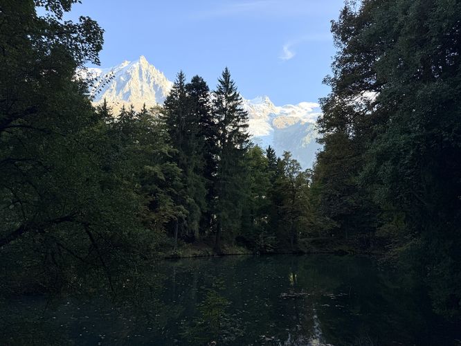
From the rock climbing area, the trail leads southwest, following an flat path as it passes through the woods. Be on the lookout for a neat cave-like structure on the north side of the path and to the south, a view of Mont Blanc with the waters of Lac Sinclair (Lake Sinclair) at your feet.

Lac Sinclair Ruins - 0.2km

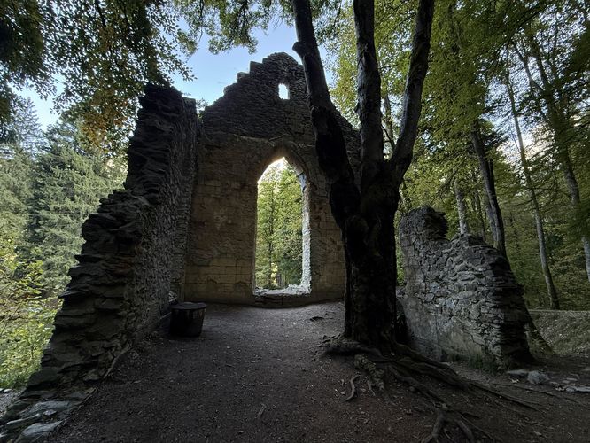
After a very short walk from the parking area, visitors will find the stone remnants of the Lac Sinclair Ruins sitting along Lac Sinclair, near 0.2km. All that remains of the stone structure are three stone walls with a large arched window frame that faces the lake. There's a stone staircase that leads to the basement of the ruins, but this old staircase simply leads to a flooded, muddy shoreline of Lac Sinclair. If you're good with photography, you may be able to capture the arched window of the ruins with a backdrop of the Mont Blanc massif in the background, although it's a bit tricky to get the lighting right.

Lac des Gaillands Views - 0.23 to 1km

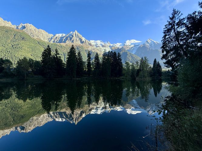
After exploring the ruins of Lac Sinclair, the walk leads visitors southeast, crossing Rte des Gaillands to reach Lac des Gaillands (Lake of the Gaillands). As you follow the loop trail around Lac des Gaillands, you'll find breathtaking views of the towering Mont Blanc massif overhead. Some of the best Mont Blanc views from the Chamonix Valley can be found right along this lake and the best part is, it's relatively quiet! If you show up when there's very-little water or air movement, the stillness of Lac des Gaillands creates a reflective mirror effect where you'll find the Mont Blanc massif shimmering like a mirror on the lake's glassy water. Some of the best views along the Lac des Gaillands trail can be found 0.88 and 1km from the start of this route.

Lac Sinclair Ruins Viewpoint - 1.13km

This route leads visitors back to the parking area, but first it stops at a scenic viewpoint of the Lac Sinclair Ruins. The trail crosses Rte des Gaillands once more but instead of following the main path to the parking lot, it leads up a short, but steep hill. From the top of the hill is one of the best views of the Lac Sinclair Ruins. On days where the wind levels are low, Lac Sinclair creates yet another reflective mirror effect where you'll find a mirror image of the ruins on the lake's water.

Return to Parking - 1.13 to 1.3km

The last section of this scenic Chamonix Valley walk leads from the Lac Sinclair Ruins Viewpoint back to the parking lot. Follow the trail that sits atop Lac Sinclair's southern banks as it wraps around the water. Along the way are more beautiful views of the lake and, located on the northeast banks, sits more stone structural ruins from buildings that are now long-gone. Hop back on the trail, pass the Les Gaillands Rock Climbing area and reach the parking lot at 1.3km to finish the walk.

Parking

Visitors will find a large parking lot at the coordinates provided, located on the north side of Rte des Gaillands in Chamonix, France. The parking lot is large enough to fit about 30 vehicles as of September 2025. If the parking lot is full, street side parking can be found along Rte des Gaillands.

Pets

Dogs are allowed if leashed and must be cleaned up after.
Explore 5 trails near Chamonix-Mont-Blanc, France
  1. Parking

    45.914956, 6.848144
  2. Main Trailhead

    45.914956, 6.848144
  3. Les Gaillands Rock Climbing

    45.915011, 6.847925
    Les Gaillands Rock Climbing
  4. View / Overlook / Vista

    45.914494, 6.846628
    View / Overlook / Vista
  5. Structure / Building

    45.914106, 6.846244
    Structure / Building
  6. View / Overlook / Vista

    45.914461, 6.84845
    View / Overlook / Vista
  7. View / Overlook / Vista

    45.913553, 6.847539
    View / Overlook / Vista
  8. View / Overlook / Vista

    45.913853, 6.846781
    View / Overlook / Vista
No community routes found. To add your own hike as a Community Route for this Trail guide, leave a Trip Report with an attached GPX file.

Seasons

All

Photo Albums

+ Add Photo Album

Upload your photos from the trail to help others know what to expect.

Trip Reports (Reviews)

Ready to help fellow hikers? Add a trip report to share your experience and provide valuable insights for those planning their next hike. Your review makes the trail better for everyone.

Rated 5.0 out of 5 based on 2 ratings.
0.8 miles / 1.3 km
September 19, 2025
Very fun walk to the ruins with an amazing reflection view of the Mont Blanc massif. Did not expect this walk to be as nice as it was. Would do this one again.
Hiking

Explore Hiking Trails

You May Also Like

Colorado's Million Dollar Highway - Plan a day's drive adventure along the iconic Million Dollar Highway in Colorado. Explore the best short trails, roadside stops, waterfalls, vistas, ghost towns, and hot springs within a ~6 hour road trip.
Explore

Colorado's Million Dollar Highway

Plan a day's drive adventure along the iconic Million Dollar Highway in Colorado. Explore the best short trails, roadside stops, waterfalls, vistas, ghost towns, and hot springs within a ~6 hour road trip.

Read
Glacier's Going-to-the-Sun Road - Discover the breathtaking beauty of Glacier National Park along the iconic Going-to-the-Sun Road. From stunning roadside stops to picturesque waterfalls and vistas, this engineering marvel offers endless opportunities for exploration.
Explore

Glacier's Going-to-the-Sun Road

Discover the breathtaking beauty of Glacier National Park along the iconic Going-to-the-Sun Road. From stunning roadside stops to picturesque waterfalls and vistas, this engineering marvel offers endless opportunities for exploration.

Read
New York's Best Waterfalls - Whether you're planning a day hike, roadside stop, or a leisurely short walk, this guide provides hikers, travelers, and locals alike with 63 different locations to over 100 scenic waterfalls to help plan your next adventure!
Explore

New York's Best Waterfalls

Whether you're planning a day hike, roadside stop, or a leisurely short walk, this guide provides hikers, travelers, and locals alike with 63 different locations to over 100 scenic waterfalls to help plan your next adventure!

Read

Before you boogie...

Find our trail guides useful? Consider becoming a Supporter to unlock perks!

MyHikes is an indie platform that makes exploring public trails easier for everyone. The platform has no investors, no ads, and is owned and operated by one person, Dave Miller. Dave has personally mapped and written over 1,800 trail guides on MyHikes for the public to explore. MyHikes has helped millions outdoor enthusiasts plan their next adventure.

But it takes a lot of time 🕦, money 💰, work, and espresso shots ☕ to run MyHikes, including hiking , mapping , writing , and publishing new trails with high-quality (accurate) information... along with software engineering (coding) the platform like building new features, website and mobile app development (iOS and Android), site maintainance . and much much more.

Supporters unlock website and mobile app perks with an annual one-time payment of $25 (you renew) 😎👍. Or you can simply make a Donation of your choice. Otherwise, you can support us by telling your friends about MyHikes - both quick and free 🎉

Admin avatar

Dave Miller
MyHikes Founder
🍪 We use cookies to learn about site usage, performance, and to serve map tiles. You may block cookies manually in the browser. By continuing to use MyHikes, you agree. Learn more