The Knife Edge Trail at Mesa Verde National Park near Mancos, Colorado is a moderate 2.1-mile out-and-back hike that runs along a long-lost park road and features views of the mesa's northern slopes high above the Montezuma Valley.
Hike
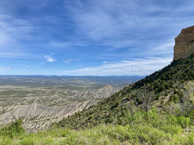
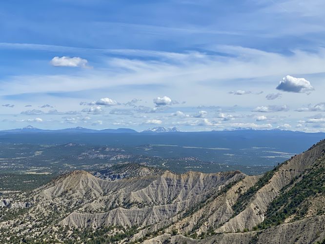
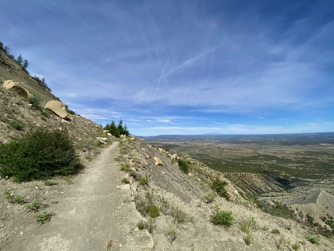
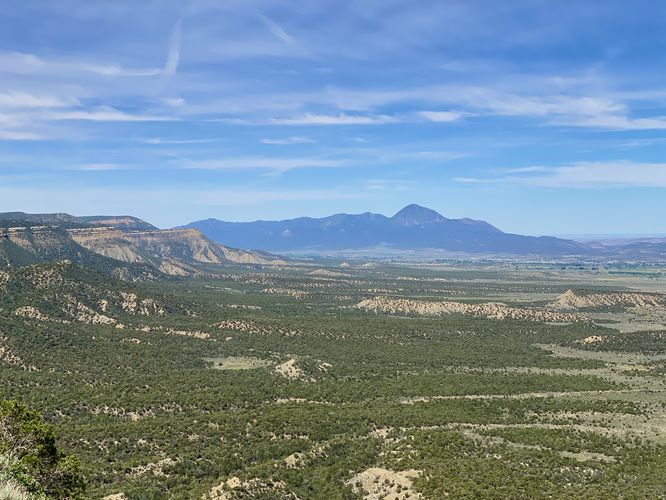
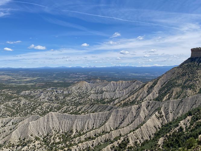
This hike begins at the main trailhead for the Knife Edge Trail, located on the northwest corner of the Morefield Campground. The trail leads-in along a relatively-flat trail that undulates along the northern slopes of Mesa Verde with views of the Montezuma Valley below. The trail has very-little shade, so almost the entire length of the trail is exposed, which makes the hike more difficult (hence the moderate difficulty). Around mile 0.25, hikers will begin to get views of the valley and Mesa Verde's rugged slopes with jagged ridges that swoop down into the valley below. Most of these views can be found along the trail until it begins to curve around the western side of the local butte around mile 0.75. Along the way, around mile 0.6, the trail will pass a very-steep slope that appears to have been part of a landslide. Just beyond the landslide-prone area, the trail bends around the local butte, you'll start to get westerly views of the mesa's green slopes and Ute Mountain as it sticks up out of the horizon in the distance. Hikers will reach a large boulder field and the end of the trail just after mile 1 where you'll find signage reminding you that the trail is in fact terminated here. The landscape beyond the sign is too dangerous for the park to build and maintain a trail, just like the original road that the trail now follows -- the mesa has different plans than humans.
After exploring the end of the trail, the 1.05-mile hike back to parking begins. The trail undulates its way back around the mesa's edge to reach the parking lot for a 2.1-mile out-and-back hike.
History of the Knife Edge Trail / Road
As translated from the historical sign about the park's first entrance road on the Montezuma Overlook: "A traveler in 1892 described a trail on the ridge before you as the Crinkly Edge Trail. In 1911, just five years after the park was established, the trail became the Knife Edge Road, a new section of the main park road. Although scenic, the road was narrow and steep, and the instability of the soil made it difficult to maintain. Two years later, the park built a bypass through Morefield and Prater Canyons. When the first automobile trip was made in 1914, vehicles used the bypass and the Knife Edge Road was soon closed. The scenic value of the Knife Edge Road prompted the park to reopen it in 1924, replacing the longer bypass. Although it continued to challenge road crews for the next 30 years, it remained in use until 1957 when the Morefield-Prater tunnel was completed."
Parking
Hikers will find a parking lot at the coordinates provided, located on Navajo Road in the park -- just northwest of the Morefield Campground. As of June 2024, the turnout is large enough to fit about a dozen vehicles.
Pets
Dogs are not allowed on this trail. Dogs are allowed on paved trails including the Park Point Trail and the Mesa Top Loop Sites including: The Navajo Canyon Overlook, Square Tower House Overlook Trail, Pithouses & Pueblos Loop, Mesa Top Sites Trail, Sun Point Pueblo, Sun Point View, Oak Tree House View, Fire Temple & New Fire House View, and the Sun Temple & Cliff Palace View.
Warning
Rattlesnakes: Mesa Verde is home to rattlesnakes that might be out basking in the sun during warm months. While encounters are rare, give any rattlers you find plenty of space.
Sun exposure: Due to the lack of trees and shade, this trail has a high exposure to the sun and weather. Plan to bring sunscreen to protect yourself against high UVs.
Steep cliffs: This trail passes through areas with steep and tall cliffs, including areas that are prone to landslides.
Hike
This hike begins at the main trailhead for the Knife Edge Trail, located on the northwest corner of the Morefield Campground. The trail leads-in along a relatively-flat trail that undulates along the northern slopes of Mesa Verde with views of the Montezuma Valley below. The trail has very-little shade, so almost the entire length of the trail is exposed, which makes the hike more difficult (hence the moderate difficulty). Around mile 0.25, hikers will begin to get views of the valley and Mesa Verde's rugged slopes with jagged ridges that swoop down into the valley below. Most of these views can be found along the trail until it begins to curve around the western side of the local butte around mile 0.75. Along the way, around mile 0.6, the trail will pass a very-steep slope that appears to have been part of a landslide. Just beyond the landslide-prone area, the trail bends around the local butte, you'll start to get westerly views of the mesa's green slopes and Ute Mountain as it sticks up out of the horizon in the distance. Hikers will reach a large boulder field and the end of the trail just after mile 1 where you'll find signage reminding you that the trail is in fact terminated here. The landscape beyond the sign is too dangerous for the park to build and maintain a trail, just like the original road that the trail now follows -- the mesa has different plans than humans.
After exploring the end of the trail, the 1.05-mile hike back to parking begins. The trail undulates its way back around the mesa's edge to reach the parking lot for a 2.1-mile out-and-back hike.
History of the Knife Edge Trail / Road
As translated from the historical sign about the park's first entrance road on the Montezuma Overlook: "A traveler in 1892 described a trail on the ridge before you as the Crinkly Edge Trail. In 1911, just five years after the park was established, the trail became the Knife Edge Road, a new section of the main park road. Although scenic, the road was narrow and steep, and the instability of the soil made it difficult to maintain. Two years later, the park built a bypass through Morefield and Prater Canyons. When the first automobile trip was made in 1914, vehicles used the bypass and the Knife Edge Road was soon closed. The scenic value of the Knife Edge Road prompted the park to reopen it in 1924, replacing the longer bypass. Although it continued to challenge road crews for the next 30 years, it remained in use until 1957 when the Morefield-Prater tunnel was completed."
Parking
Hikers will find a parking lot at the coordinates provided, located on Navajo Road in the park -- just northwest of the Morefield Campground. As of June 2024, the turnout is large enough to fit about a dozen vehicles.
Pets
Dogs are not allowed on this trail. Dogs are allowed on paved trails including the Park Point Trail and the Mesa Top Loop Sites including: The Navajo Canyon Overlook, Square Tower House Overlook Trail, Pithouses & Pueblos Loop, Mesa Top Sites Trail, Sun Point Pueblo, Sun Point View, Oak Tree House View, Fire Temple & New Fire House View, and the Sun Temple & Cliff Palace View.
Warning
Rattlesnakes: Mesa Verde is home to rattlesnakes that might be out basking in the sun during warm months. While encounters are rare, give any rattlers you find plenty of space.
Sun exposure: Due to the lack of trees and shade, this trail has a high exposure to the sun and weather. Plan to bring sunscreen to protect yourself against high UVs.
Steep cliffs: This trail passes through areas with steep and tall cliffs, including areas that are prone to landslides.