Loading...

🌲 WINTER SALE! 50% OFF on Supporter Accounts — now through December 31st. Unlock a full year of exclusive website & app perks for better hikes. Learn More.

Grand Tour of Switzerland Davos Klosters

Directions
Map
Pictures
Download Grand Tour of Switzerland Davos Klosters GPX Data to the MyHikes Mobile App
Distance:
0 km / 0 Miles
Type:
Out-and-Back
Difficulty:
Easy
Time to Hike:
~5 minutes
Features:
Surface Type:
Universal Access
Town:
Davos, Switzerland
Get Directions:
46.779797, 9.928948
Added:
September 26, 2025
Updated:
November 24, 2025
Copy Trail Link Hiking this trail? Send a friend or family member a link to this trail guide for your own safety. Hike at your own risk (disclaimer)
Loading...

Download the GPX Data for Offline Use

Supporters get exclusive access to download trail routes to the MyHikes app for offline use. Stay prepared on your adventure, even without an internet connection! Become a Supporter today to unlock this feature and hike with confidence.

Download Grand Tour of Switzerland Davos Klosters GPX Data to the MyHikes Mobile App

Key Takeaways

  • This is a spectacular, low-effort stop on the Grand Tour of Switzerland. Park your car and enjoy the massive Swiss Alps panorama with only a short walk—no strenuous hiking required.
  • Capture the stunning, west-facing view and the dramatic cascading waterfall plunging into the pass (a unique feature of this high-alpine viewpoint). Perfect for Flüela Pass photography.
  • Strategically located for visitors staying in the resorts, this viewpoint is an essential, easy-to-reach highlight for any Davos or Klosters itinerary or scenic drive through the Graubünden region.

Grand Tour of Switzerland Davos Klosters

Discover one of the most stunning and easily accessible viewpoints on the Grand Tour of Switzerland: the Davos/Klosters vista in Flüela Pass.

Located just a short drive from Davos and Klosters, this spot offers a truly iconic Swiss Alps panorama without requiring a strenuous hike. It's the perfect stop for families, photographers, or anyone seeking a quick dose of breathtaking mountain beauty along this famous touring route.

Flüela Pass: Your Easy Access Grand Tour of Switzerland Viewpoint near Davos/Klosters

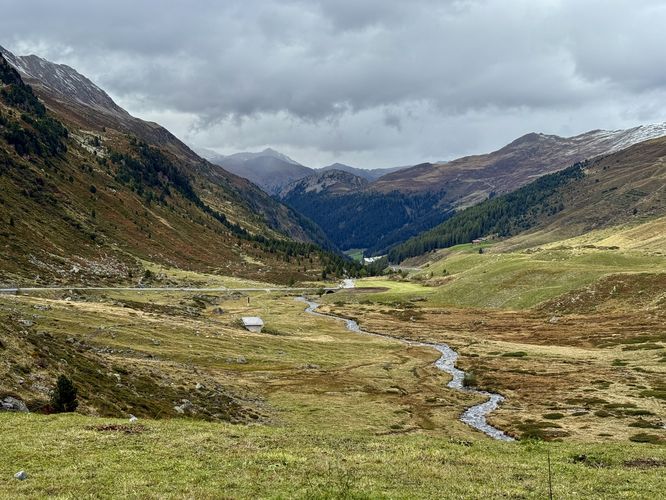
The western side of the Flüela Pass provides a spectacular viewpoint right off the main road. After parking, it's just a short walk to the edge where the landscape dramatically unfolds. Look west to capture the sheer scale of the high Alps, and turn your attention north to find a large waterfall plunging down the steep mountainside into the valley below. This spot is a must-see for capturing the essence of Swiss mountain passes and the Graubünden region. A perfect spot for Swiss Alps road trippers!

Davos & Klosters Day Trip Must-Do

If you're basing your stay in the popular resorts of Davos or Klosters, a drive over the Flüela Pass is an essential day trip. The pass itself is an incredible experience, but this particular viewpoint is the highlight. It provides a unique perspective of the surrounding peaks and is an excellent location for sunset photography, offering those spectacular west-facing views.

Parking & Directions: Getting to the Grand Tour of Switzerland Davos/Klosters Viewpoint

Accessibility is key at this location. There are designated parking areas near the viewpoint on the western slope of the pass. From the parking lot, the walk to the prime viewing spot is very short and manageable for almost everyone, hence its universal accessibility. Pack a light jacket, even in summer, as the high-altitude air can be brisk! This is the epitome of an easy Alps photo stop on the Grand Tour of Switzerland.

Important Visitor Information

Seasonal Road Closures: The Flüela Pass road is typically closed during the winter months (approximately late October/November through May) due to heavy snow and avalanche risk. Always check the current road status before planning your trip.

Elevation: Remember you are in a high alpine environment. Even this short walk is at a high elevation, so the air will be cooler and thinner. Dress in layers!

Explore More Flüela Pass Photo Stops

While the western viewpoint is a must-see, the adventure doesn't end there! Make the most of your drive through this spectacular alpine route by adding two more essential roadside attractions to your itinerary. The breathtaking Flüela Pass Falls is a short, dramatic stop to witness a 130-meter tall waterfall. For a tranquil, high-altitude lake setting, pull over at the Lai da la Scotta Viewpoint to admire the crystal-clear waters reflecting the surrounding peaks. These easy-access stops are perfect for adding variety to your photo collection and experiencing the full beauty of the Grand Tour of Switzerland drive through Graubünden.
Explore 9 trails near Davos, Switzerland
  1. Parking

    46.779797, 9.928948
  2. Main Trailhead

    46.779797, 9.928948
  3. View of Flüela Pass from Davos/Klosters Grand Tour of Switzerland Lookout Point

    46.779836, 9.928906
    View of Flüela Pass from Davos/Klosters Grand Tour of Switzerland Lookout Point
No community routes found. To add your own hike as a Community Route for this Trail guide, leave a Trip Report with an attached GPX file.

Seasons

Spring, Summer, Fall

Photo Albums

+ Add Photo Album

Upload your photos from the trail to help others know what to expect.

Preview of the MyHikes mobile app interface

Track, Log, and Explore Hikes with the MyHikes App

Shop Landscape Prints
Shop our Alps landscape prints to support MyHikes!

Trip Reports (Reviews)

Ready to help fellow hikers? Add a trip report to share your experience and provide valuable insights for those planning their next hike. Your review makes the trail better for everyone.

Rated 4.0 out of 5 based on 1 rating.
0 miles / 0 km
September 26, 2025
Beautiful views of the western side of Fluela Pass near Davos. If you're following the Grand Tour of Switzerland road trip signs, do not miss this one. A large waterfall even plummets into the mountain pass just uphill from the lookout point.
Hiking

Explore Hiking Trails

You May Also Like

Colorado's Million Dollar Highway - Plan a day's drive adventure along the iconic Million Dollar Highway in Colorado. Explore the best short trails, roadside stops, waterfalls, vistas, ghost towns, and hot springs within a ~6 hour road trip.
Explore

Colorado's Million Dollar Highway

Plan a day's drive adventure along the iconic Million Dollar Highway in Colorado. Explore the best short trails, roadside stops, waterfalls, vistas, ghost towns, and hot springs within a ~6 hour road trip.

Read
Glacier's Going-to-the-Sun Road - Discover the breathtaking beauty of Glacier National Park along the iconic Going-to-the-Sun Road. From stunning roadside stops to picturesque waterfalls and vistas, this engineering marvel offers endless opportunities for exploration.
Explore

Glacier's Going-to-the-Sun Road

Discover the breathtaking beauty of Glacier National Park along the iconic Going-to-the-Sun Road. From stunning roadside stops to picturesque waterfalls and vistas, this engineering marvel offers endless opportunities for exploration.

Read
New York's Best Waterfalls - Whether you're planning a day hike, roadside stop, or a leisurely short walk, this guide provides hikers, travelers, and locals alike with 63 different locations to over 100 scenic waterfalls to help plan your next adventure!
Explore

New York's Best Waterfalls

Whether you're planning a day hike, roadside stop, or a leisurely short walk, this guide provides hikers, travelers, and locals alike with 63 different locations to over 100 scenic waterfalls to help plan your next adventure!

Read

Before you boogie...

Find our trail guides useful? Consider becoming a Supporter to unlock perks!

MyHikes is an indie platform that makes exploring public trails easier for everyone. The platform has no investors, no ads, and is owned and operated by one person, Dave Miller. Dave has personally mapped and written over 1,800 trail guides on MyHikes for the public to explore. MyHikes has helped millions outdoor enthusiasts plan their next adventure.

But it takes a lot of time 🕦, money 💰, work, and espresso shots ☕ to run MyHikes, including hiking , mapping , writing , and publishing new trails with high-quality (accurate) information... along with software engineering (coding) the platform like building new features, website and mobile app development (iOS and Android), site maintainance . and much much more.

Supporters unlock website and mobile app perks with an annual one-time payment of $25 (you renew) 😎👍. Or you can simply make a Donation of your choice. Otherwise, you can support us by telling your friends about MyHikes - both quick and free 🎉

Admin avatar

Dave Miller
MyHikes Founder
🍪 We use cookies to learn about site usage, performance, and to serve map tiles. You may block cookies manually in the browser. By continuing to use MyHikes, you agree. Learn more