Loading...

🌲 WINTER SALE! 50% OFF on Supporter Accounts — now through December 31st. Unlock a full year of exclusive website & app perks for better hikes. Learn More.

Flüela Pass Falls

Directions
Map
Pictures
Download Flüela Pass Falls GPX Data to the MyHikes Mobile App
Distance:
0.2 km / 0.1 Miles
Type:
Out-and-Back
Difficulty:
Easy
Time to Hike:
~5 minutes
Features:
Surface Type:
Dirt
Town:
Davos, Switzerland
Get Directions:
46.741591, 9.969348
Added:
September 26, 2025
Updated:
November 24, 2025
Copy Trail Link Hiking this trail? Send a friend or family member a link to this trail guide for your own safety. Hike at your own risk (disclaimer)
Loading...
Loading...
5m

Total Change
5m

Ascent
5m

Descent

Download the GPX Data for Offline Use

Supporters get exclusive access to download trail routes to the MyHikes app for offline use. Stay prepared on your adventure, even without an internet connection! Become a Supporter today to unlock this feature and hike with confidence.

Download Flüela Pass Falls GPX Data to the MyHikes Mobile App

Key Takeaways

  • Easily access the 130m (426 ft) Flüela Pass Falls directly from Route 28 near Davos/Zernez. This is the perfect, effort-free roadside attraction for travelers seeking spectacular Swiss Alpine views without a long hike.
  • Enjoy immediate and stunning photo opportunities of the massive cascading waterfall from the small parking lot. An optional short trail provides east-facing panoramic views of the high alpine valley.
  • Located on the magnificent Flüela Pass (2,384 m/7,822 ft), remember to check seasonal road closures (Oct-May) and dress for the cool, thin air of this high-alpine environment.

Flüela Pass Falls

Looking for a stunning alpine view that requires minimal effort? The Flüela Pass Falls offers an incredibly accessible and rewarding stop on your drive through the breathtaking Swiss Alps near Davos, Graubünden.

This is the perfect roadside attraction for all visitors—from families to road trippers—who want to experience this 130-meter (426-foot) waterfall and soak in spectacular east-facing mountain pass views without embarking on a long hike.

Flüela Pass Falls, Davos: Your Quick-Stop Swiss Waterfall Viewpoint!

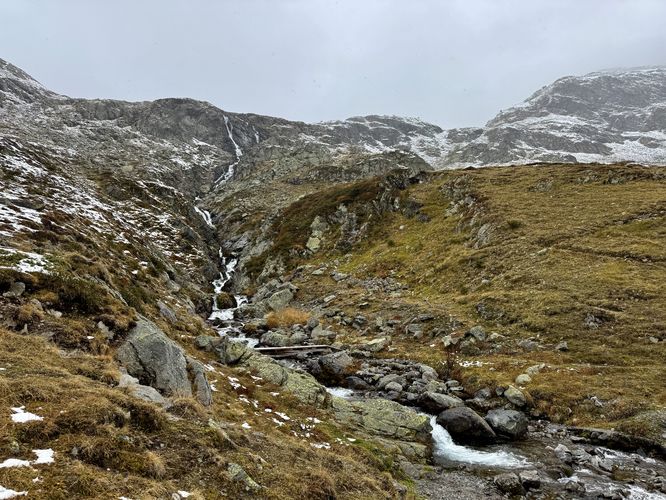
As you pull into the small parking area on the south side of Route 28 on the eastern side of Flüela Pass, the massive, cascading waterfall is immediately visible, tumbling down the rugged mountainside. Fed by high-elevation alpine lakes, the 130-meter (426-foot) tall waterfall is hard to miss.

From the parking lot, it's just a few steps (about 10 meters) to the designated viewing area. Snap your photo, enjoy the mist, and appreciate the power of the falls!

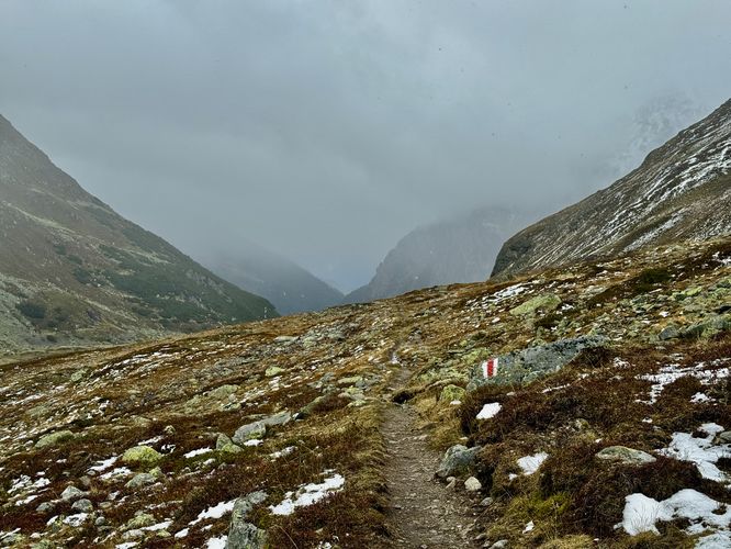
For visitors with a few extra minutes to spare, the public trail offers a short walk to beautiful views of the mountain pass. This well-maintained trail offers slightly different perspectives of the waterfall and opens up to fantastic east-facing panoramic views of the surrounding Flüela Pass landscape and the high alpine valley toward Susch/Zernez.

Important Visitor Information

Seasonal Road Closures: The Flüela Pass road is typically closed during the winter months (approximately late October/November through May) due to heavy snow and avalanche risk. Always check the current road status before planning your trip.

Elevation: Remember you are in a high alpine environment. Even this short walk is at a high elevation, so the air will be cooler and thinner. Dress in layers!

Parking & Directions: Getting to Flüela Pass Falls

The Flüela Pass (connecting Davos and Susch/Zernez) is a magnificent high-mountain road (elevation 2,384 m / 7,822 ft).

From Zernez/Susch (Engadine Valley): Drive west on Route 28 up the pass. The waterfall and parking area will be on your left (south side of the road) as you gain elevation.

From Davos: Drive east on Route 28 over the pass summit. The falls and parking will be on your right (south side) as you begin your descent toward Susch.

Pets

Dogs are allowed only if leashed and must be cleaned up after.

Explore More Flüela Pass Photo Stops

While the waterfall is a must-see, the adventure doesn't end there! Make the most of your drive through this spectacular alpine route by adding two more essential roadside attractions to your itinerary. The breathtaking Grand Tour of Switzerland: Davos/Klosters viewpoint is a short, dramatic stop that features breathtaking Alps views of the western side of the mountain pass. For a tranquil, high-altitude lake setting, pull over at the Lai da la Scotta Viewpoint to admire the crystal-clear waters reflecting the surrounding peaks. These easy-access stops are perfect for adding variety to your photo collection and experiencing the full beauty of the Grand Tour of Switzerland drive through Graubünden.
Explore 7 trails near Davos, Switzerland
  1. Parking

    46.741591, 9.969348
  2. Main Trailhead

    46.741603, 9.969399
  3. Flüela Pass Falls (130-meters / 426-feet tall)

    46.741539, 9.969189
    Flüela Pass Falls (130-meters / 426-feet tall)
  4. Cloudy view of Flüela Pass from the hiking trail

    46.741486, 9.969842
    Cloudy view of Flüela Pass from the hiking trail
No community routes found. To add your own hike as a Community Route for this Trail guide, leave a Trip Report with an attached GPX file.

Seasons

Spring, Summer, Fall

Photo Albums

+ Add Photo Album

Upload your photos from the trail to help others know what to expect.

Preview of the MyHikes mobile app interface

Track, Log, and Explore Hikes with the MyHikes App

Shop Landscape Prints
Shop our Alps landscape prints to support MyHikes!

Trip Reports (Reviews)

Ready to help fellow hikers? Add a trip report to share your experience and provide valuable insights for those planning their next hike. Your review makes the trail better for everyone.

Rated 4.0 out of 5 based on 1 rating.
0.1 miles / 0.2 km
September 26, 2025
The waterfall in Fluela Pass was an unexpected stop on our road trip drive from Ortisei through Davos on our way to Weesen. Great views of the waterfall from the parking lot but the walk is worth exploring especially to see the 130-meter waterfall up close. Great views of the mountain pass too.
Hiking

Explore Hiking Trails

You May Also Like

Colorado's Million Dollar Highway - Plan a day's drive adventure along the iconic Million Dollar Highway in Colorado. Explore the best short trails, roadside stops, waterfalls, vistas, ghost towns, and hot springs within a ~6 hour road trip.
Explore

Colorado's Million Dollar Highway

Plan a day's drive adventure along the iconic Million Dollar Highway in Colorado. Explore the best short trails, roadside stops, waterfalls, vistas, ghost towns, and hot springs within a ~6 hour road trip.

Read
Glacier's Going-to-the-Sun Road - Discover the breathtaking beauty of Glacier National Park along the iconic Going-to-the-Sun Road. From stunning roadside stops to picturesque waterfalls and vistas, this engineering marvel offers endless opportunities for exploration.
Explore

Glacier's Going-to-the-Sun Road

Discover the breathtaking beauty of Glacier National Park along the iconic Going-to-the-Sun Road. From stunning roadside stops to picturesque waterfalls and vistas, this engineering marvel offers endless opportunities for exploration.

Read
New York's Best Waterfalls - Whether you're planning a day hike, roadside stop, or a leisurely short walk, this guide provides hikers, travelers, and locals alike with 63 different locations to over 100 scenic waterfalls to help plan your next adventure!
Explore

New York's Best Waterfalls

Whether you're planning a day hike, roadside stop, or a leisurely short walk, this guide provides hikers, travelers, and locals alike with 63 different locations to over 100 scenic waterfalls to help plan your next adventure!

Read

Before you boogie...

Find our trail guides useful? Consider becoming a Supporter to unlock perks!

MyHikes is an indie platform that makes exploring public trails easier for everyone. The platform has no investors, no ads, and is owned and operated by one person, Dave Miller. Dave has personally mapped and written over 1,800 trail guides on MyHikes for the public to explore. MyHikes has helped millions outdoor enthusiasts plan their next adventure.

But it takes a lot of time 🕦, money 💰, work, and espresso shots ☕ to run MyHikes, including hiking , mapping , writing , and publishing new trails with high-quality (accurate) information... along with software engineering (coding) the platform like building new features, website and mobile app development (iOS and Android), site maintainance . and much much more.

Supporters unlock website and mobile app perks with an annual one-time payment of $25 (you renew) 😎👍. Or you can simply make a Donation of your choice. Otherwise, you can support us by telling your friends about MyHikes - both quick and free 🎉

Admin avatar

Dave Miller
MyHikes Founder
🍪 We use cookies to learn about site usage, performance, and to serve map tiles. You may block cookies manually in the browser. By continuing to use MyHikes, you agree. Learn more