Loading...

🌲 WINTER SALE! 50% OFF on Supporter Accounts — now through December 31st. Unlock a full year of exclusive website & app perks for better hikes. Learn More.

Lai da la Scotta Viewpoint

Directions
Map
Pictures
Download Lai da la Scotta Viewpoint GPX Data to the MyHikes Mobile App
Distance:
0 km / 0 Miles
Type:
Out-and-Back
Difficulty:
Easy
Time to Hike:
~5 minutes
Features:
Surface Type:
Dirt
Town:
Davos, Switzerland
Get Directions:
46.751841, 9.945235
Added:
September 26, 2025
Updated:
November 24, 2025
Copy Trail Link Hiking this trail? Send a friend or family member a link to this trail guide for your own safety. Hike at your own risk (disclaimer)
Loading...

Download the GPX Data for Offline Use

Supporters get exclusive access to download trail routes to the MyHikes app for offline use. Stay prepared on your adventure, even without an internet connection! Become a Supporter today to unlock this feature and hike with confidence.

Download Lai da la Scotta Viewpoint GPX Data to the MyHikes Mobile App

Key Takeaways

  • Lai da la Scotta offers a stunning, high-alpine panorama directly on Flüela Pass (Route 28), making it the best view accessible with no hiking required for those staying in the Davos area.
  • A perfect roadside break for travelers crossing the Flüelapass, featuring immediate access to a scenic vista overlooking the lake and the historic Flüela Hospiz Passhotel.
  • Use the coordinates 46.751841,9.945235 to easily locate the small, convenient dirt parking lot right next to the viewpoint, ensuring you don't miss this spectacular photo opportunity.

Lai da la Scotta Viewpoint

Lai da la Scotta Viewpoint on Flüela Pass (Route 28), offers a breathtaking alpine vista accessible directly from your vehicle. It's the perfect stop for anyone seeking stunning Swiss scenery without requiring a hike, especially if you're exploring the area around Davos and the Lower Engadin Valley.

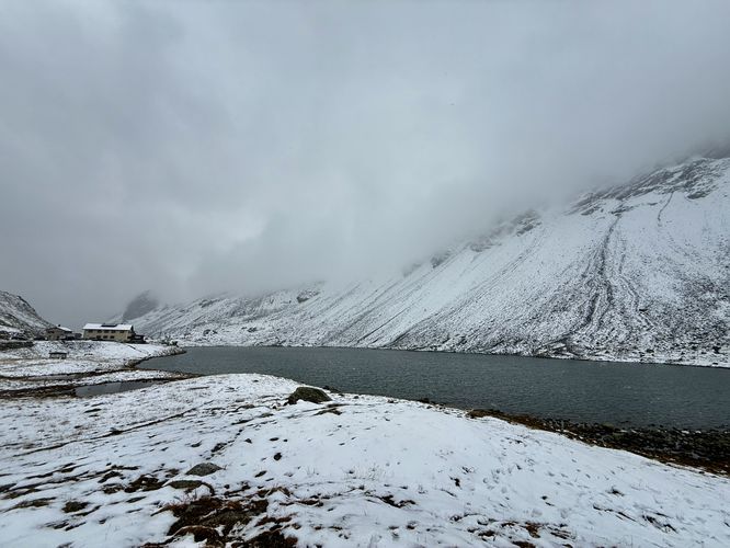
Lai da la Scotta Viewpoint: Easy Alpine Lake View near Davos

Forget long treks—the Lai da la Scotta Viewpoint offers one of the easiest high-alpine lake views in Switzerland. Located right off Route 28 on the Flüela Pass, this stunning vista requires only a few steps outside your car. It's an ideal break for drivers and passengers traveling between Davos/Klosters and Zernez/St. Moritz. Capture postcard-worthy photos of the deep blue lake set against the rugged Flüela Pass peaks.

Parking & Direcionts: Getting to Lai da la Scotta

Directly at the viewpoint coordinates, you will find a small dirt parking area. This parking lot is perfect for a quick stop-and-go photo opportunity of Lai d la Scotta (Lake of the Scotta). The main lake basin is easily visible from this point, framed by the impressive surrounding peaks. Visitors will find the parking lot can fit less than 10 vehicles as of September 2025, but a similar sized parking lot can be found on the north side of Route 28 as well.

A Must-See Stop on Flüela Pass (Route 28)

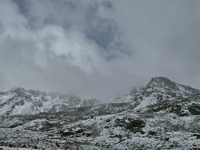
The Flüela Pass, or Flüelapass, is one of the most scenic mountain passes in the canton of Graubünden. Adding the Lai da la Scotta Viewpoint to your itinerary ensures you experience the best of this mountain pass route. It's a key highlight for visitors looking for things to do near Davos that showcase the dramatic elevation and beauty of the Alps. Drive carefully, take your photos, and enjoy the height of Swiss scenery!

Important Visitor Information

Seasonal Road Closures: The Flüela Pass road is typically closed during the winter months (approximately late October/November through May) due to heavy snow and avalanche risk. Always check the current road status before planning your trip.

Elevation: Remember you are in a high alpine environment. Even this short walk is at a high elevation, so the air will be cooler and thinner. Dress in layers!

Explore More Flüela Pass Photo Stops

While the Lake of the Scotta is a must-see, the adventure doesn't end there! Make the most of your drive through this spectacular alpine route by adding two more essential roadside attractions to your itinerary. The breathtaking Grand Tour of Switzerland: Davos/Klosters viewpoint is a short, dramatic stop that features breathtaking Swiss Alps views of the western side of the mountain pass. And the breathtaking Flüela Pass Falls is a short, dramatic stop to witness a 130-meter tall waterfall. These easy-access stops are perfect for adding variety to your photo collection and experiencing the full beauty of the Grand Tour of Switzerland drive through Graubünden.
Explore 7 trails near Davos, Switzerland
  1. Parking

    46.751841, 9.945235
  2. Main Trailhead

    46.751841, 9.945235
  3. View of Lake Scotta (Lai da la Scotta) on Flüela Pass

    46.751681, 9.945064
    View of Lake Scotta (Lai da la Scotta) on Flüela Pass
  4. View of alpine mountains of Flüela Pass

    46.751789, 9.945139
    View of alpine mountains of Flüela Pass
No community routes found. To add your own hike as a Community Route for this Trail guide, leave a Trip Report with an attached GPX file.

Seasons

Spring, Summer, Fall

Photo Albums

+ Add Photo Album

Upload your photos from the trail to help others know what to expect.

Preview of the MyHikes mobile app interface

Track, Log, and Explore Hikes with the MyHikes App

Shop Landscape Prints
Shop our Alps landscape prints to support MyHikes!

Trip Reports (Reviews)

Ready to help fellow hikers? Add a trip report to share your experience and provide valuable insights for those planning their next hike. Your review makes the trail better for everyone.

Rated 4.0 out of 5 based on 1 rating.
0 miles / 0 km
September 26, 2025
A nice roadside stop in the middle of Fluela Pass to views of the alpine lake. When we showed up the temperature had dropped quite a bit so it was actually freezing outside. We did not stay for very long but the views were nice and were worth stepping out of the car on our road trip drive from Ortisei to Weesen that day.
Hiking

Explore Hiking Trails

You May Also Like

Colorado's Million Dollar Highway - Plan a day's drive adventure along the iconic Million Dollar Highway in Colorado. Explore the best short trails, roadside stops, waterfalls, vistas, ghost towns, and hot springs within a ~6 hour road trip.
Explore

Colorado's Million Dollar Highway

Plan a day's drive adventure along the iconic Million Dollar Highway in Colorado. Explore the best short trails, roadside stops, waterfalls, vistas, ghost towns, and hot springs within a ~6 hour road trip.

Read
Glacier's Going-to-the-Sun Road - Discover the breathtaking beauty of Glacier National Park along the iconic Going-to-the-Sun Road. From stunning roadside stops to picturesque waterfalls and vistas, this engineering marvel offers endless opportunities for exploration.
Explore

Glacier's Going-to-the-Sun Road

Discover the breathtaking beauty of Glacier National Park along the iconic Going-to-the-Sun Road. From stunning roadside stops to picturesque waterfalls and vistas, this engineering marvel offers endless opportunities for exploration.

Read
New York's Best Waterfalls - Whether you're planning a day hike, roadside stop, or a leisurely short walk, this guide provides hikers, travelers, and locals alike with 63 different locations to over 100 scenic waterfalls to help plan your next adventure!
Explore

New York's Best Waterfalls

Whether you're planning a day hike, roadside stop, or a leisurely short walk, this guide provides hikers, travelers, and locals alike with 63 different locations to over 100 scenic waterfalls to help plan your next adventure!

Read

Before you boogie...

Find our trail guides useful? Consider becoming a Supporter to unlock perks!

MyHikes is an indie platform that makes exploring public trails easier for everyone. The platform has no investors, no ads, and is owned and operated by one person, Dave Miller. Dave has personally mapped and written over 1,800 trail guides on MyHikes for the public to explore. MyHikes has helped millions outdoor enthusiasts plan their next adventure.

But it takes a lot of time 🕦, money 💰, work, and espresso shots ☕ to run MyHikes, including hiking , mapping , writing , and publishing new trails with high-quality (accurate) information... along with software engineering (coding) the platform like building new features, website and mobile app development (iOS and Android), site maintainance . and much much more.

Supporters unlock website and mobile app perks with an annual one-time payment of $25 (you renew) 😎👍. Or you can simply make a Donation of your choice. Otherwise, you can support us by telling your friends about MyHikes - both quick and free 🎉

Admin avatar

Dave Miller
MyHikes Founder
🍪 We use cookies to learn about site usage, performance, and to serve map tiles. You may block cookies manually in the browser. By continuing to use MyHikes, you agree. Learn more